

Community hub
Recent from talks
Contribute something
Nothing was collected or created yet.
Astoria Column
View on Wikipedia
Astoria Column | |
 The Astoria Column in 2024 | |
| Location | Astoria, Oregon, U.S. |
|---|---|
| Coordinates | 46°10′53″N 123°49′03″W / 46.18139°N 123.81750°W |
| Built | 1926, 100 years ago |
| NRHP reference No. | 74001681 |
| Added to NRHP | May 2, 1974 |
The Astoria Column is a tower in the northwest United States, overlooking the mouth of the Columbia River on Coxcomb Hill in Astoria, Oregon. Built in 1926, the concrete and steel structure is part of a 30-acre (12 ha) city park called Astor Park.
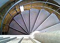
The 125-foot (38 m)-tall column has a 164-step spiral staircase ascending to an exterior observation deck at the top.[1]
History
[edit]The tower was built in 1926 with financing by the Great Northern Railway and Vincent Astor, the great-grandson of John Jacob Astor, in commemoration of the city's role in the family's business history. Patterned after the Trajan Column in Rome (and Place Vendôme Column in Paris), the Astoria Column was dedicated on July 22, 1926.[2][3][4][5] Maintenance work was done in 1936.[6] In 1974, the column was listed in the National Register of Historic Places.[7] The murals that make up the column were refurbished in 1995 and a granite plaza was added in 2004.[8]
The column was one of a series of monuments erected by Great Northern between 1925 and 1926.[9]
Details
[edit]
The 125-foot-tall (38 m) column stands atop 600-foot (180 m) Coxcomb Hill and includes an interior spiral staircase that leads to an observation deck at the top.[3] The spiral sgraffito frieze on the exterior of the structure has a width of nearly seven feet (2.1 m) and a length of 525 feet (160 m).[3] Projected by Electus D. Litchfield and painted by Attilio Pusterla,[10] the mural shows 14 significant events in the early history of Oregon, as well as 18 scenes from the history of the region, including Captain Gray's discovery of the Columbia River in 1792 and the Lewis and Clark Expedition.[3] The frieze starts with the "pristine forest" and concludes with the arrival of the railway in Astoria.[11]
Constructed of concrete, its foundation is twelve feet (3.7 m) deep.[8] Built at a cost of $27,134 (equivalent to $493,461 in 2025), the tower has 164 steps to the top, where there is a replica of the State Seal of Oregon.[8]
A plaque near the column commemorates the pioneering Community Antenna Television (CATV) system built by local resident Leroy E. "Ed" Parsons, initially at the Hotel Astoria, in which twin-lead transmission wires redistributed the signal of KRSC-TV (now KING-TV) in Seattle, Washington to area homes. Former Astoria resident Byron Roman was also involved in early cable invention and distribution.[12][13]
The cast-iron spiral staircase inside the column was closed for safety reasons in November 2007. It was reopened to the public in time for the Regatta in August 2009.[14]
Gallery
[edit]-
 Astoria Column in a rainbow
 -
 Newspaper on the day of dedication
 -
 Detail of the column mural
 -
 Roof
Roof -
 Spiral staircase (looking down)
 -
 Spiral staircase (looking up)
 -
 The column at night
 -
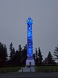 The column in blue lighting


.jpg)
_(clatDA0074c).jpg)

See also
[edit]Other Great Northern memorials
[edit]- Verendrye, North Dakota
- Camp Disappointment (Meriwether), Montana
- Marias Pass (Summit), Montana
- Bonners Ferry, Idaho
- Wishram, Washington
References
[edit]- ^ "The Astoria Column: Your visit to Astoria, Oregon starts here". The Astoria Column. Retrieved 2024-07-14.
- ^ "Astoria to hold big celebration". Eugene Guard. Oregon. July 9, 1926. p. 2.
- ^ a b c d Corning, Howard M. Dictionary of Oregon History. Binfords & Mort Publishing, 1956.
- ^ "Astoria Column, Coxcomb Hill". Spokesman-Review. Spokane, Washington. Associated Press. July 13, 1926. p. 7.
- ^ "The Column at Astoria". Eugene Guard. Oregon. July 24, 1926. p. 4.
- ^ "News and Comment", Oregon Historical Quarterly vol. 37 no. 3.
- ^ "Oregon National Register List" (PDF). State of Oregon. Archived (PDF) from the original on 10 September 2008. Retrieved 2008-08-19.
- ^ a b c "The Astoria Column". Friends of the Astoria Column, Inc. 2007. Archived from the original on 16 August 2008. Retrieved 2008-08-19.
- ^ Young, F. G. (September 1926). "The Columbia River Historical Expedition: The Achievement and Its Promise". Oregon Historical Quarterly. 27 (3). Oregon Historical Society: 292–294. JSTOR 20610354.
- ^ Perez, Andrea Larson (2016). Astoria. Arcadia Publishing. p. 64. ISBN 978-1-4671-1647-3.
- ^ "Artwork of the Column". astoriacolumn.org. Friends of the Astoria Column. Retrieved 2020-02-01.
- ^ The History Of Public Access Television
- ^ "The Cable Center". Archived from the original on 2007-09-27. Retrieved 2007-03-20.
- ^ "Local News | KEZI". Archived from the original on 2011-07-13. Retrieved 2009-06-06.
External links
[edit]- "Friends of the Astoria Column". Retrieved 2012-04-12.
- "Astoria Column". Geographic Names Information System. United States Geological Survey, United States Department of the Interior. Retrieved 2012-04-12.
- Filips, Janet. "Astoria Column". The Oregon Encyclopedia.
![]() Media related to Astoria Column at Wikimedia Commons
Media related to Astoria Column at Wikimedia Commons
Astoria Column
View on GrokipediaOverview
Location and Setting
The Astoria Column is situated atop Coxcomb Hill in Astoria, Oregon, at an elevation of approximately 600 feet above sea level.[7] This prominent position places it at the highest point in the city, providing a commanding overlook of the surrounding coastal landscape.[5] The monument is integrated into the 30-acre Astoria Park, which the City of Astoria purchased in 1914 using funds from centennial celebrations to create a public recreational area.[5] The park features a mix of forested trails winding through stands of Sitka spruce, western hemlock, and understory vegetation like salal and salmonberry, alongside open spaces suitable for picnicking and gatherings near the column's base.[8] These natural elements enhance the site's role as a serene urban escape, with paths like the Cathedral Tree Trail offering alternative access to the column through the wooded hillside. From the column's observation deck, visitors enjoy 360-degree panoramic views encompassing the Columbia River to the north, Young's Bay to the east, the Pacific Ocean to the west, and the coastal mountains of the Coast Range on clear days.[7] These vistas highlight the strategic geography of the Pacific Northwest, where river meets sea, and are a key draw for approximately 400,000 annual visitors.[7] The site's geographic coordinates are 46°10′53″N 123°49′03″W, and it is accessible via Coxcomb Drive, a winding road leading from downtown Astoria, with directional signs on 14th and 16th Streets guiding drivers to the parking area at 1 Coxcomb Drive.[10][11]Purpose and Significance
The Astoria Column was constructed to commemorate the rich history of the Pacific Northwest, particularly honoring the region's natural resources and the early settlers who harnessed them for development. The monument's site was prepared during Astoria's centennial celebration in 1911, which marked the 100th anniversary of the city's founding as the first permanent American settlement on the Pacific Coast, but the column itself was formally proposed in 1925 by Great Northern Railway president Ralph Budd.[5][1] It aimed to celebrate the area's pioneering spirit and economic growth driven by timber, fishing, and trade. The initiative gained momentum through partnerships, reflecting a broader effort to preserve and promote the narrative of regional progress from indigenous stewardship to European-American expansion.[5] Symbolizing America's westward expansion, the column prominently features the Lewis and Clark Expedition's arrival at the Columbia River mouth in 1805–1806, encapsulating the exploratory zeal that paved the way for U.S. territorial claims in the Oregon Country. Its sgraffito murals depict this journey alongside other pivotal events, such as Captain Robert Gray's discovery of the Columbia River in 1792 and the establishment of Fort Astoria by John Jacob Astor in 1811, underscoring the monument's role in narrating the intertwined stories of exploration, commerce, and settlement.[2][1] This symbolic focus positions the Astoria Column as a tangible emblem of Manifest Destiny and the Pacific Northwest's integration into the nation.[5] Recognized for its enduring historical value, the Astoria Column was listed on the National Register of Historic Places in 1974, affirming its architectural and cultural merit as a well-preserved example of early 20th-century monumental art.[5][1] It also serves as a contributing property to the Lewis and Clark National Historic Trail, linking visitors to the expedition's legacy through interpretive elements and proximity to related sites like Fort Clatsop.[2] As a premier tourist attraction, it draws approximately 400,000 visitors annually, providing panoramic views that enhance its appeal while stimulating the local economy through tourism-related activities and reinforcing Astoria's identity as a gateway to the region's heritage.[7][1]Historical Development
Conception and Planning
The idea for a prominent monument on Coxcomb Hill in Astoria, Oregon, originated in 1898, when local boosters proposed constructing an electrified tower designed to rival the Eiffel Tower in Paris, capitalizing on the hill's commanding panoramic views of the Columbia River and surrounding landscape.[5][2] In 1914, the City of Astoria purchased 30 acres on Coxcomb Hill for development. Interest in the project was revived during Astoria's centennial celebrations in 1911, marking 100 years since the city's founding; a committee installed a temporary electric sign reading "1811-1911" at the hill's summit, and 70-year-old resident John Friend Chitwood personally cleared a path to the top to facilitate access and promote the site.[5] In 1917, Astor Park was created on the site with the erection of a flagpole for a July 4th celebration. The devastating fire that swept through downtown Astoria in 1922, destroying much of the commercial district, accelerated local rebuilding efforts and renewed calls for a lasting symbol of resilience and heritage, though initial monument proposals were shelved as too expensive.[5][1] In 1925, Ralph Budd, president of the Great Northern Railway, announced plans for a permanent monument on Coxcomb Hill as the capstone of a series of historical markers along the railway's route from Minnesota to the Pacific Northwest, aiming to commemorate key events in regional exploration and development.[5][1][2] The project was funded through contributions from Vincent Astor, great-great-grandson of John Jacob Astor, who donated $20,000, architect Electus D. Litchfield, who donated $200, with the Great Northern Railway covering the remaining costs; the total expenditure reached $27,133.96, equivalent to approximately $494,000 in 2025 dollars.[1][12]Construction and Dedication
Construction of the Astoria Column commenced in March 1926, undertaken by the St. Paul-based firm A.B. Guthrie and Company under the project management of the Great Northern Railway.[5][13] The process began with the pouring of a 12-foot-deep foundation to support the structure on the unstable hillside of Coxcomb Hill, followed by the erection of the 100-foot concrete shaft reinforced with steel for stability.[14] The total height of the monument, including the cupola and viewing platform, reached 125 feet, topped by a bronze statue of a ship under sail.[1] Inside, a 164-step spiral staircase was installed by the Portland Wire and Iron Works to provide access to the observation deck.[5] The overall construction cost $27,134, with allocations including $15,000 for the main build, $2,875 for the staircase, $1,000 in architect fees, and $7,500 for the exterior artwork.[1] The column's design, crafted by New York architect Electus D. Litchfield, drew inspiration from ancient Roman monuments such as Trajan's Column, adopting a neoclassical style with a fluted shaft and ornate capital to evoke imperial grandeur while commemorating regional history.[5][13] Litchfield's plans emphasized durability against the coastal climate, utilizing reinforced concrete for the primary structure to ensure longevity.[14] By early May 1926, the core shaft was substantially complete, allowing for the subsequent application of the exterior murals, though these remained unfinished at the time of the opening.[5] The Astoria Column was dedicated on July 22, 1926, as the culminating event of the three-day Astoria Founders Celebration, drawing over 8,000 attendees despite the incomplete murals.[1][13] The ceremony featured lectures on Astoria's historical ties to New York and the Pacific Northwest by speakers including writer Lawrence Abbott, British Columbia Judge Frederic Howay, and local historian Margaret Aldrich, highlighting the monument's role in linking the city's founding to broader American exploration narratives.[13] At the event, the column was hailed as "the greatest of western monuments."[1] Full completion, including the murals by artist Attilio Pusterla, was achieved on October 29, 1926.[5]Architectural Features
Design and Structure
The Astoria Column is a monumental tower modeled after ancient Roman victory columns, such as Trajan's Column, to evoke classical grandeur through its tall, tapering form and architectural proportions.[15] Designed by architect Electus D. Litchfield, the structure stands 125 feet tall and consists of a reinforced concrete shaft built over an internal steel spiral staircase core, providing durability against the harsh coastal winds and weather of the Pacific Northwest.[16][17] The shaft features a cylindrical barrel that measures 13 feet 6 inches in diameter at its base, tapering slightly to 11 feet 4 inches at the top, and rises 94 feet 6 inches high, supported by vertical reinforcing rods embedded in the concrete for structural integrity.[16] In 1976, steel rods were added to the foundation for additional reinforcement.[5] At ground level, the column rests on a square base measuring 19 feet 6 inches on each side and 13 feet 6 inches in height, constructed of the same reinforced concrete to form a stable foundation.[16] In 2005, as part of improvements funded by nearly $2 million for the Lewis and Clark Bicentennial, a granite plaza was added around the base to enhance stability, aesthetics, and accessibility, accompanied by seismic reinforcements to the foundation for improved earthquake resistance.[5] The tower is crowned by a domed cupola featuring a small glass dome and balustrade-enclosed observation platform, which provides panoramic views and was accessed via the internal steel staircase.[16] Atop the cupola sits a beacon light, originally installed to guide and deflect night-flying aircraft in the early aviation era.[16]Interior and Accessibility
The interior of the Astoria Column features a 164-step cast-iron spiral staircase that winds around a central core, providing access from the base to the observation deck at the top.[11][18] This staircase, originally installed in 1926 by the Portland Wire and Iron Works, was constructed to support heavy visitor traffic and has been climbed by millions over the decades.[5] In 2009, it was replaced with a more durable cast-steel version.[5][1] The staircase ascends to an observation deck, which offers unobstructed panoramic views of the Columbia River, Youngs Bay, and surrounding landscapes.[5] Encircling the deck is a parapet, designed for visitor safety and providing a secure barrier against the elevated height.[5] Accessibility to the column's base has been enhanced through targeted improvements. In 2005, as part of a $2 million bicentennial upgrade funded by the Friends of the Astoria Column, a granite plaza and ADA-compliant walkway were installed, facilitating easier approach for visitors with mobility challenges.[5] These additions, along with upgrades to the parking lot and surrounding paths, provide wheelchair-accessible routes to the column's entrance and interpretive areas, though the interior staircase remains inaccessible due to its narrow spiral design.[5][11] Elevator alternatives, such as assisted transport options coordinated through park staff, are available upon request for those unable to climb.[11] The column's accessibility history includes a period of closure during World War II, from 1942 to 1947, when Coxcomb Hill was repurposed by the U.S. Navy as a navigational air facility for security reasons.[5] Upon reopening to the public in 1947, modern safety railings were added to the observation deck to comply with updated building codes, a process further refined in 1995 with full railing replacements.[5] These measures have ensured the interior remains a functional and secure space for visitors today.[5]Artistic Elements
Exterior Murals
The exterior of the Astoria Column is adorned with a spiraling sgraffito frieze, measuring 525 feet in length and nearly seven feet in width, that encircles the concrete shaft from base to near the top.[5] This monumental artwork, the first use of sgraffito on such a large-scale column, was created by Italian immigrant artist Attilio Pusterla, who applied it during the summer of 1926 using a mobile wooden scaffold suspended from the structure's 110-foot viewing platform.[5][19] Pusterla hauled his detailed drawings up to the scaffold daily, working with a team to execute the intricate designs over approximately 120 days.[7][19] The sgraffito technique employed a base layer of white cement coated with brown plaster, which Pusterla and his assistants incised with tools to expose the contrasting white beneath, forming vivid figures and landscapes against the dark background; colored powders were then hand-blown into the incisions for added depth and detail.[1][7] The frieze comprises 14 sequential panels chronicling the history of the Pacific Northwest, beginning with pre-contact scenes of Native American life among the Clatsop and Chinook peoples and culminating in the arrival of the railroad to Astoria in 1893.[5][20] Key vignettes include the welcoming of Captain Robert Gray by Clatsop Tribal members during his 1792 exploration of the Columbia River, the Lewis and Clark expedition's encampment at Fort Clatsop in 1805, the founding of Fort Astoria by John Jacob Astor's traders in 1811, bustling fur trade activities, overland wagon trains of pioneers, and the introduction of steamships to the region.[1][5] These panels, featuring over 200 figures in total, provide a visual narrative of exploration, settlement, and economic development along the lower Columbia River.[7] Early deterioration from coastal weather prompted repairs in 1936, when Pusterla returned to restore damaged sections and apply waterproofing treatments.[5] Further maintenance occurred in 1989, when workers meticulously cleaned the frieze using toothbrushes to remove grime, though the murals remained faded from prolonged exposure.[5] In 1995, a major restoration involved cleaning the exterior surface, stabilizing cracks, and applying siloxane-based sealants to protect the sgraffito artwork.[5] Another comprehensive restoration in 2015, costing approximately $1 million, further preserved the frieze through surface cleaning, crack stabilization, and water-repellent treatments, ensuring its longevity.[5]Inscriptions and Symbolism
At the base of the Astoria Column, engraved inscriptions commemorate key milestones in the region's history, including the arrival of Lewis and Clark in 1805, the extension of rail service to Astoria in 1893, and the monument's own erection in 1926.[1] These texts also include dedications to pivotal figures such as Captain Robert Gray, who first entered the Columbia River in 1792, the Lewis and Clark Expedition, and John Jacob Astor, whose fur trading enterprise established Fort Astoria as the first permanent American settlement west of the Rockies.[1][2] The monument's symbolism underscores a narrative of historical progression, beginning with indigenous stewardship by the Clatsop and Chinook peoples and advancing through European exploration, maritime trade, pioneer settlement, and industrialization culminating in the railroad's arrival.[1][2] This sequence reflects the 1920s boosterism promoted by Great Northern Railway president Ralph Budd, who envisioned the column as a tribute to Astoria's role in American westward expansion and economic development.[1] Culturally, the inscriptions and overall design emphasize harmony between nature and human endeavor, portraying the Columbia River as a unifying force in the Pacific Northwest's transformation while highlighting secular themes of progress without religious or overt political motifs.[1][21] This interpretive framework celebrates a shared historical legacy, focusing on exploration and settlement as drivers of regional identity.[2]Preservation and Modern Use
Restorations and Maintenance
The Astoria Column has undergone several restorations since its completion in 1926 to address weathering, structural vulnerabilities, and deterioration of its sgraffito murals. In 1936, just a decade after dedication, the original artist Attilio Pusterla returned to repair damage from exposure and apply a waterproof coating to the murals, funded by contributions totaling $5,500 from the Astor family ($3,000), the Great Northern Railway ($500), and the City of Astoria ($2,000).[5] Subsequent protective treatments in 1948 and 1958 involved city workers applying tung oil to the artwork as a water-resistant finish, though these efforts led to darkening and accumulation of dirt over time. In 1968, city workers applied white latex paint and epoxy to cracks, though these measures proved ineffective.[5] Structural concerns prompted further interventions in the mid-1970s, when X-rays revealed cracks in the reinforced concrete tower; in 1976, the city closed the monument temporarily to install metal rings and steel rods for reinforcement, stabilizing the wire mesh support system.[5] By the late 1980s, ongoing deterioration necessitated organized preservation; the nonprofit Friends of Astoria Column, founded in 1988, raised funds for initial cleaning efforts, including scrubbing the surface with toothbrushes in 1989.[1] This culminated in a major $1 million restoration in 1995, led by renowned conservator Frank Preusser, who cleaned the surfaces, restored the murals using historical photographs for accuracy—at that time, only about 20% of the original artwork remained—applied a water-repellent treatment, rebuilt the doors, restored the cupola and its windows, replaced the copper finial, and updated the railings; Preusser recommended future cycles every eight to 15 years.[5] Later projects focused on both structural and aesthetic enhancements. In 2008, as part of broader grounds improvements from 2005 to 2008 costing nearly $2 million, the interior spiral staircase was fully replaced to ensure safety and durability, with collaboration between the City of Astoria and the Friends group.[5] A subsequent $1 million restoration in 2015 addressed cracking, delamination, and spalling through exterior cleaning, artwork restoration, architectural repairs, and upgrades to the plaza and landscaping, including the installation of LED lighting to highlight the murals while aiding preservation visibility.[5] Ongoing maintenance is handled by the City of Astoria's parks department, supported by the Friends of Astoria Column, with a comprehensive manual guiding periodic treatments and projections for the next major work in 20 to 30 years.[5][3]Visitor Experience and Access
The Astoria Column is accessible via a approximately 2-mile drive from downtown Astoria, following well-marked signs on 14th or 16th Streets that lead uphill to Coxcomb Drive.[11] Entry to the site is free, with the park open daily from 5 a.m. to 10 p.m. and the column itself available from dawn to dusk; a $5 parking fee per vehicle grants access for one year.[6][2] On-site facilities include a gift shop offering souvenirs such as balsa wood gliders, public restrooms with disabled access, and picnic tables scattered throughout the surrounding Astoria Park for visitors to enjoy meals amid the natural setting.[3][22] The column's exterior murals serve as interpretive exhibits, vividly depicting scenes from the Lewis and Clark Expedition, the discovery of the Columbia River, and interactions with local Indigenous peoples, providing educational context on the region's history.[23] Summer months, particularly June through August, offer the clearest panoramic views from the column's summit, with warm, dry weather enhancing visibility of the Columbia River, Youngs Bay, and distant coastal landmarks.[24] The site hosts annual events, including serving as a prime vantage point for Independence Day fireworks launched over the Astoria waterfront.[25] It is pet-friendly, allowing leashed dogs in the park areas, though pets are not permitted inside the column.[26] Visitors should note potential windy conditions at the top, which can make the 164-step spiral staircase and observation deck challenging, especially on gusty days.[24] Drone use is prohibited to protect the historic structure and ensure safety.[6] The site is managed by the Astoria Parks Department, with operational and preservation support from the nonprofit Friends of Astoria Column, which handles maintenance, education, and visitor services.[3][27]References
- https://www.alltrails.com/trail/us/[oregon](/page/Oregon)/cathedral-tree-trail--2