
Community hub
0 subscribers8 pages, 0 posts
Recent from talks
All channels
Be the first to start a discussion here.
Be the first to start a discussion here.
Be the first to start a discussion here.
Be the first to start a discussion here.
Contribute something
Welcome to the community hub built to collect knowledge and have discussions related to Bushahr.
Nothing was collected or created yet.
Bushahr
View on Wikipediafrom Wikipedia
Bushahr, also spelt as 'Bashahr' and 'Bussahir' or 'Bushair' was a Rajput princely state in India during the British Raj. It was located in the hilly western Himalaya promontory bordering Tibet.
Key Information

History
[edit]

In 1898, Bushahr state was taken over by the British administration, although the Râja remained nominally in charge.[1] After British occupation, the Bushahr state was by far the largest of the 28 Simla Hills States.[citation needed] There was a tax revolt by Bushahr's peasants in 1906.[1]

Rulers
[edit]Rulers bore the title of Rana and then Raja.[2][3]
Ranas
- : Kehri Singh
- 1780 - 1799: Ram Singh
- 1799 - 1803 : Ugar Singh
- 1803 - 1815 : Nepalese occupation
Rajas
- 1816 - 1850 : Mahendra Singh
- 1850 - 1887 : Shamsher Singh
- 1887 - 1898 : Raghunath Singh
- 1898 - 1914 : Shamsher Singh (return to power)
- 1914 - 1947 : Padam Singh
- 1947 - 2021 : Virbhadra Singh[4][5]
- 2021 - till date : Vikramaditya Singh[6][7]
See also
[edit]References
[edit]- ^ a b Chisholm, Hugh, ed. (1911). . Encyclopædia Britannica. Vol. 3 (11th ed.). Cambridge University Press. p. 464.
- ^ "Indian Princely States before 1947 A-J". www.worldstatesmen.org. Retrieved 30 August 2019.
- ^ "Indian states before 1947 A-J". rulers.org. Retrieved 30 August 2019.
- ^ "Virbhadra Singh: Congress stalwart, Himachal's Raja Sahib passes away at 87". Hindustan Times. 9 July 2021. Retrieved 10 July 2021.
- ^ "Virbhadra Singh dies: Rampur Bushahr mourns the passing of 'Raja sahab'". The Indian Express. 9 July 2021. Retrieved 10 July 2021.
- ^ "Bushashr Royalty: Vikramaditya Singh Crowned As 'Raja Sahib' In Private Ceremony". www.outlookindia.com. 10 July 2021. Archived from the original on 10 July 2021. Retrieved 10 July 2021.
- ^ Service, Tribune News. "Vikramaditya's 'raj tilak' before Raja's cremation". Tribuneindia News Service. Retrieved 10 July 2021.
External links
[edit]Bushahr
View on Grokipediafrom Grokipedia
Geography
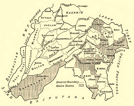
Location and Historical Boundaries
Bushahr State occupied a strategic position in the western Himalayan region, corresponding to much of present-day Shimla and Kinnaur districts in Himachal Pradesh, India, with its administrative headquarters at Rampur. The territory was traversed by the Sutlej River, which bisected the state and facilitated trade routes toward Tibet. Its core area lay between the Sutlej and Yamuna river basins, encompassing rugged mountainous terrain rising to elevations over 15,000 feet in the east.[1][3] In the early 20th century, Bushahr's boundaries extended approximately from 31.6° to 32.4° N latitude and 77.33° to 79.2° E longitude, as recorded in the 1910 Bushahr State Gazetteer. The eastern frontier abutted Tibet, demarcated by the Kailash mountain range following ancient treaties that resolved territorial disputes. To the north, it neighbored Spiti; southward, it bordered Garhwal (later Tehri); and westward, it adjoined Jubbal, Kulu, Lahaul, and parts of Mandi states. These limits were formalized under British suzerainty after the Anglo-Gurkha War of 1814–1816, which restored Bushahr's sovereignty following Gurkha occupation from 1803 to 1815.[3][4] Historically, Bushahr's boundaries underwent shifts through conquests and alliances. During the reign of Rana Ram Singh (1725–1761), the state lost territories to Kulu amid regional power struggles. Medieval expansions under earlier Bhati Rajput rulers incorporated adjacent hill tracts, but Gurkha incursions temporarily reduced its extent until British intervention. Post-independence in 1947, Bushahr acceded to India, with its lands integrated into Himachal Pradesh, where modern administrative divisions largely align with the princely state's 19th- and early 20th-century contours, though minor adjustments occurred during state reorganizations in 1954 and 1966.[2]Terrain and Natural Features
Bushahr State occupied a rugged terrain in the western Himalayan region, spanning approximately 84 miles in length from east to west and varying in width from 62 miles at its eastern extremity to 12 miles in the west.[3] The landscape featured steep mountain slopes and deep valleys, primarily within the Lesser Himalayan zone, with elevations ranging from about 900 meters in the lower Sutlej Valley to over 2,700 meters in higher elevations.[3][5] The Sutlej River, one of the major tributaries of the Indus, traversed the central valley of Bushahr, carving out significant gorges and providing a vital waterway through the otherwise formidable topography.[6][7] Natural vegetation included dense coniferous forests of deodar, pine, and oak in the mid-altitude zones, supporting diverse wildlife adapted to the temperate climate.[8] Higher altitudes transitioned to alpine scrub and barren rocky outcrops, influenced by the proximity to the Tibetan plateau.[9] Climatic conditions varied markedly with altitude, from subtropical in the lower valleys around Rampur Bushahr at 1,005 meters to cold temperate and alpine in the upper reaches, with heavy monsoon rains fostering the forested cover and snow accumulation on peaks during winter.[6][3] The region's natural features, including snow-capped mountains and riverine ecosystems, contributed to its isolation and strategic importance historically.[7]History
Legendary and Early Origins
According to traditional legends preserved in regional accounts, the Bushahr dynasty originated with Pradyumna, the son of Lord Krishna, who is said to have founded the ruling line by defeating and marrying the daughter of Banasur, the demon king and local chief of Shonitpur (identified with parts of ancient Kinnaur).[10] This mythological narrative links the state's foundation to events from the Mahabharata era, portraying the rulers as divine descendants who established authority over the Himalayan hill tracts through conquest and alliance.[2] Such origin myths emphasize Bushahr's antiquity as one of the oldest hill principalities in the Western Himalayas, second only to Kashmir in traditional chronologies, with the dynasty claiming unbroken Rajput lineage from prehistoric times.[2] These stories, while unverifiable empirically, reflect local oral histories and genealogical claims documented in princely records, often invoked to legitimize hereditary rule amid sparse archaeological evidence of early settlements.[11] Historical records of early origins remain fragmentary, pointing to indigenous chieftains controlling the Kamru area—near modern Sangla in Kinnaur—as the nucleus of power, with fortified structures like Kamru Fort serving as the initial seat of governance from indeterminate ancient dates.[11] [12] Expansion under early figures like Chatar Singh, who consolidated territories in the medieval period, suggests a gradual coalescence of tribal holdings into a cohesive state by the 15th century, though precise founding dates elude confirmation beyond legendary attributions.[13] Local traditions also incorporate divine elements, such as the deity Dev Badrinath symbolically crowning the inaugural ruler, underscoring the interplay of sacral kingship in pre-modern Himalayan polities.[14]Medieval Expansion and Consolidation (15th–18th Centuries)
Raja Chatar Singh, the 110th ruler in the Bushahr dynasty, initiated the state's medieval expansion by unifying fragmented territories and exercising effective control over the entire domain for the first time, transforming Bushahr into one of the prominent hill states.[15] His efforts focused on incorporating adjacent regions, including parts of Kinnaur, which bolstered the state's administrative coherence and military capacity.[16] This consolidation laid the groundwork for subsequent rulers to build upon, shifting Bushahr from loose feudal holdings to a more centralized polity amid rivalries with neighboring powers. Raja Kalyan Singh, the 112th ruler and successor to Chatar Singh, further advanced territorial integration by adding key thakurais (subordinate estates) such as Dulaitoo, Kurungoloo, and Kuaitro, enhancing Bushahr's hold over peripheral areas.[1] These acquisitions strengthened internal governance and resource extraction, particularly in forested and high-altitude zones vital for trade routes. By the late 17th century, Raja Kehri Singh, the 113th ruler, emerged as the period's most dynamic leader, renowned for military victories that repelled Tibetan incursions under commanders like Guldenchhen and secured dominance in Upper Kinnaur.[10] Kehri Singh's campaigns, including clashes with Mughal forces during Aurangzeb's era, not only expanded Bushahr's borders but also fortified its defenses, earning him recognition as a skilled warrior who significantly consolidated the state's power.[1] The 18th century witnessed fluctuations, with temporary losses of annexed lands during the weaker reign of Raja Rudra Singh, yet Raja Ugar Singh reclaimed these territories, preserving the gains of prior expansions.[17] This era of assertive rajaship emphasized military organization and strategic alliances, enabling Bushahr to navigate threats from Gorkha and Sikh influences encroaching on Himalayan fringes, ultimately solidifying its boundaries by the late 1700s.[1] Through these developments, Bushahr evolved into a resilient entity with defined administrative parganas and a hereditary rajput lineage that prioritized territorial integrity over the preceding centuries of intermittent feudalism.19th-Century Developments and Conflicts
In the early 19th century, the princely state of Bushahr faced significant external threats from Gurkha forces originating from Nepal, who expanded aggressively into the Himalayan hill regions between 1803 and 1815.[1] The Gurkhas, under leaders like Amar Singh Thapa, overran several hill states, including Bushahr, imposing heavy tribute demands and military occupation that disrupted local governance and economy.[18] Raja Ugar Singh (r. circa 1785–1810), the 118th ruler, attempted to resist by dispatching an army against the invaders, but his death in 1810 facilitated Gurkha consolidation of control over Bushahr's territories, including key passes and trade routes.[13][18] The tide turned with the outbreak of the Anglo-Gurkha War (1814–1816), during which local hill rulers, including Bushahr's leadership under successor Raja Mahendra Singh (r. 1810–circa 1840s), provided auxiliary support to British forces in exchange for liberation from Gurkha dominance.[4] British expeditions, led by figures such as Major General David Ochterlony, targeted Gurkha strongholds in the hills, culminating in the Treaty of Sugauli (1816), which compelled Gurkha withdrawal from Bushahr and neighboring states.[19] As a result, on November 6, 1815, the British East India Company issued a sanad (charter) to Raja Mahendra Singh, restoring most of Bushahr's pre-invasion territories while annexing certain peripheral thakurais (minor estates) like those in the Simla region to direct British administration; this arrangement positioned Bushahr as the largest among the 28 Simla Hill States under British suzerainty.[4][15] Post-war developments included the formalization of Bushahr's protectorate status, which stabilized internal rule but introduced British oversight on foreign affairs and border disputes, limiting the raja's autonomy in military matters.[20] The state also became a conduit for British interests in trans-Himalayan trade, particularly after mid-century disruptions in Ladakh from the Dogra-Tibetan War (1834–1842), which redirected Tibetan shawl wool exports through Bushahr's routes as a British dependency.[21] Under later rulers like Shamsher Singh (r. circa 1860s–1914), the state experienced relative peace, though occasional tensions arose over tribute obligations to the Sikh Empire under Ranjit Singh prior to full British ascendancy, which the 1846 Treaty of Amritsar resolved by affirming British paramountcy in the hills.[22] These shifts marked Bushahr's transition from vulnerable autonomy to protected princely status, averting further large-scale conflicts while embedding it in colonial strategic networks.[20]British Suzerainty and Protectorate Status
Following the Anglo-Nepalese War of 1814–1816, during which Gurkha forces had occupied Bushahr from approximately 1803 to 1815, the British East India Company expelled the Gurkhas and established suzerainty over the Shimla Hill States, including Bushahr.[4] Raja Mahendra Singh, who had sought refuge in Kinnaur during the occupation, was restored to power and granted a sanad on 6 November 1815 (or 8 February 1816 per some records), recognizing his rule in exchange for loyalty and assistance against the Gurkhas.[4][20] This sanad confirmed Bushahr's internal autonomy while placing it under British protectorate status, with the Company assuming responsibility for external defense and foreign relations.[20] Under this arrangement, Bushahr retained its dynastic governance and local administration, but British paramountcy prohibited independent alliances, wars, or territorial expansions without approval, and required the provision of troops or resources when demanded.[23] The state, the largest among the Shimla Hill States, was administered through a British political agent based in Shimla, who oversaw compliance and mediated disputes.[24] During the Indian Rebellion of 1857, Bushahr's ruler remained loyal to the British, avoiding the direct conflicts that affected some other princely states.[4] Mahendra Singh ruled until 1850, followed by Shamsher Singh (1850–1887), during whose reign British influence deepened through infrastructure projects like the Hindustan-Tibet Road traversing Bushahr's territories.[25] In 1898, amid concerns over administrative mismanagement and possibly the Raja's minority, the British assumed direct control via an administrative takeover, rendering the ruler titular while a British superintendent managed state affairs until stability was restored.[26] Subsequent rulers, including Raghunath Singh (1887–1898) and a returning Shamsher Singh (1898–1914), operated under this enhanced oversight, maintaining the protectorate framework until India's independence in 1947.[25]Accession to India and Post-Independence Changes
Bushahr acceded to the Dominion of India in late 1947, when British paramountcy lapsed on 15 August 1947, prompting princely rulers to sign Instruments of Accession transferring control over defense, external affairs, and communications to the central government.[2] Under Raja Padam Singh (r. 1914–1947), the state formally integrated into the Indian Union while initially preserving limited internal autonomy, aligning with the efforts of Sardar Vallabhbhai Patel to unify over 560 princely states.[27] This accession occurred without significant conflict, reflecting the state's strategic Himalayan position and prior British protectorate status since the early 19th century. On 15 April 1948, Bushahr merged with 29 other Punjab Hill States—including Chamba, Mandi, and Sirmaur—to establish the Chief Commissioner's Province of [Himachal Pradesh](/page/Himachal Pradesh), covering approximately 27,169 square kilometers.[28] The merger agreement, signed by the rulers, dissolved Bushahr's sovereignty, reallocating its territories—primarily the Rampur Bushahr pargana and Kinnaur valley—into new districts like Mahasu (later Shimla) and emerging Kinnaur administrative units, with Rampur serving as a key sub-divisional headquarters.[1] This consolidation ended feudal governance structures, introducing direct central oversight and paving the way for uniform legal and fiscal policies across the region. Following integration, Bushahr's former domains underwent administrative reforms, including the extension of India's constitution and elective bodies by 1952, alongside land tenure changes that redistributed jagirs and reduced princely privileges.[29] Raja Virbhadra Singh, who succeeded Padam Singh in 1947, received a privy purse of ₹2,40,000 annually until its abolition under the 26th Amendment in 1971, after which the family retained titular status and properties like Padam Palace.[2] Economic shifts emphasized infrastructure development, such as roads linking Rampur to Shimla, though the rugged terrain limited immediate industrialization, preserving agrarian and pastoral economies into the 1950s.[30]Governance and Rulers
Dynastic Lineage and Succession
The Bushahr dynasty, ruling from ancient Kamru Fort and later Rampur, traced its legendary origins to Pradyumna, son of Krishna, who purportedly established the line to marry the daughter of the local demon king Banasura in Sonitpur (modern Kinnaur region).[2] Historical accounts, however, attribute the dynasty's foundation to Rana Danbar Singh, a Rajput migrant from the Deccan, around 1412 CE, with the family belonging to the Bhati Rajput clan.[2] The rulers styled themselves as Rajas or Ranas, maintaining a continuous male-line descent that purportedly numbered over 120 sovereigns by the 20th century, though such enumerations likely incorporate semi-mythical early figures to assert antiquity.[2] Succession adhered to agnatic primogeniture, passing the throne to the eldest legitimate son, as was customary among Himalayan Rajput states, with deviations rare but including abdications and regencies during external threats.[2] The Gurkha invasion from 1803 to 1815 temporarily displaced the line, ending with British intervention and the restoration of Raja Mahendra Singh in 1815 via treaty, confirming hereditary rights under suzerainty.[2] A notable irregularity occurred in 1887 when Raja Shamsher Singh abdicated amid disputes, yielding to his brother Raghunath Singh until 1898, after which Shamsher resumed rule until 1914.[2] Key rulers in the documented lineage include:| Ruler | Reign | Notable Events |
|---|---|---|
| Chattar Singh (110th) | c. 17th century | Unified disparate territories into a cohesive state.[2] |
| Kehri Singh (113th) | c. late 17th century | Expanded influence; associated with early Rampur development.[2] |
| Ram Singh (116th) | 1725–1761 | Transferred capital from Sarahan to Rampur for strategic reasons.[2] |
| Mahendra Singh | 1815–1850 | Restored post-Gurkha era; received British sanad affirming succession.[2] |
| Shamsher Singh | 1850–1887, 1898–1914 | Oversaw modernization; abdication and return marked familial tensions.[2] |
| Padam Singh | 1914–1947 | Knighted by British; navigated transition to Indian independence.[2] |