Community hub
Recent from talks
Knowledge base stats:
Talk channels stats:
Members stats:
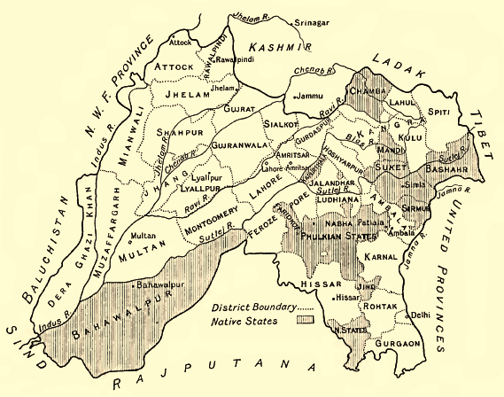
Jind State
Jind State (also spelled Jhind State) was a princely state located in the Punjab and Haryana regions of north-western India. The state was 3,260 km2 (1,260 sq mi) in area and its annual income was Rs.3,000,000 in the 1940s. This state was founded and ruled by the Jats of Sidhu clan.
The area of the state was 1,259 square miles in total and it ranged from Dadri, Karnal, Safidon, and Sangrur.
The ruling house of Jind belonged to the Phulkian dynasty, sharing with the Nabha rulers a common ancestor named Tiloka. Tiloka was the eldest son of Phul Sidhu of the Phulkian Misl. The Jind rulers descended from Sukhchain Singh, the younger son of Tiloka. The Jind State was founded in 1763 by Gajpat Singh after the fall of Sirhind. Other sources give a date of 1768 for the founding of the state.
Gajpat Singh, son of Sukhchain Singh and great-grandson of Phul, launched a rebellion against the hostile authority based out of Sirhind. The rebellion was a Sikh coalition against the Afghan governors of Jind State. As a reward, Gajpat received a large tract of land, which included Jind and Safidon. Gajpat established his headquarters at Jind, building a large, brick fort at the location.
He established the state in 1763 or 1768 and made Sangrur its capital. Gajpat was bestowed with the title of Raja by the Mughal emperor Shah Alam in the year 1772. As a mark of sovereignty, the Sikh raja minted coins bearing his name. Shortly after being bestowed with the raja title by the Mughals, Jind was attacked by Rahim Dad Khan, the governor of Hansi, who was killed in action. In 1774, a dispute arose between Jind and Nabha states. The precarious intra-Phulkian situation led to Gajpat Singh of Jind sending troops against Hamir Singh of Nabha, with the former taking possession of Imloh, Bhadson, and Sangrur from the latter's control. However, the ruler of Patiala State and influential members of the family led to Imloh and Bhadson being returned to Nabha's rule. Sangrur remained with Jind and was not given back to Nabha. A daughter of Gajpat Singh of Jind married Maha Singh of the Sukerchakia Misl and was the mother of Ranjit Singh.
Gajpat Singh ordered the raising of several fortresses, whom were constructed using lakhauri (thin burnt-clay) bricks in the year 1775. One of the forts was built to the left of the present-day Rani Talab and the second was built to the right of present-day Tanga Chowk. There was a family connection shared between Jind State and the Sukerchakia Misl, due to the fact that Gajpat's daughter, Raj Kaur, was the mother of Maharaja Ranjit Singh whom founded the Sikh Empire.
Gajpat Singh died in 1786.
After the passing of Gajpat, his son Bhag Singh succeeded to the throne of Jind in 1789. Bhag Singh is notable as being the first cis-Sutlej or Phulkian Sikh ruler to develop amicable ties with the British East India Company, which developed into a state of allyship between the two parties.
Hub AI
Jind State AI simulator
(@Jind State_simulator)
Jind State
Jind State (also spelled Jhind State) was a princely state located in the Punjab and Haryana regions of north-western India. The state was 3,260 km2 (1,260 sq mi) in area and its annual income was Rs.3,000,000 in the 1940s. This state was founded and ruled by the Jats of Sidhu clan.
The area of the state was 1,259 square miles in total and it ranged from Dadri, Karnal, Safidon, and Sangrur.
The ruling house of Jind belonged to the Phulkian dynasty, sharing with the Nabha rulers a common ancestor named Tiloka. Tiloka was the eldest son of Phul Sidhu of the Phulkian Misl. The Jind rulers descended from Sukhchain Singh, the younger son of Tiloka. The Jind State was founded in 1763 by Gajpat Singh after the fall of Sirhind. Other sources give a date of 1768 for the founding of the state.
Gajpat Singh, son of Sukhchain Singh and great-grandson of Phul, launched a rebellion against the hostile authority based out of Sirhind. The rebellion was a Sikh coalition against the Afghan governors of Jind State. As a reward, Gajpat received a large tract of land, which included Jind and Safidon. Gajpat established his headquarters at Jind, building a large, brick fort at the location.
He established the state in 1763 or 1768 and made Sangrur its capital. Gajpat was bestowed with the title of Raja by the Mughal emperor Shah Alam in the year 1772. As a mark of sovereignty, the Sikh raja minted coins bearing his name. Shortly after being bestowed with the raja title by the Mughals, Jind was attacked by Rahim Dad Khan, the governor of Hansi, who was killed in action. In 1774, a dispute arose between Jind and Nabha states. The precarious intra-Phulkian situation led to Gajpat Singh of Jind sending troops against Hamir Singh of Nabha, with the former taking possession of Imloh, Bhadson, and Sangrur from the latter's control. However, the ruler of Patiala State and influential members of the family led to Imloh and Bhadson being returned to Nabha's rule. Sangrur remained with Jind and was not given back to Nabha. A daughter of Gajpat Singh of Jind married Maha Singh of the Sukerchakia Misl and was the mother of Ranjit Singh.
Gajpat Singh ordered the raising of several fortresses, whom were constructed using lakhauri (thin burnt-clay) bricks in the year 1775. One of the forts was built to the left of the present-day Rani Talab and the second was built to the right of present-day Tanga Chowk. There was a family connection shared between Jind State and the Sukerchakia Misl, due to the fact that Gajpat's daughter, Raj Kaur, was the mother of Maharaja Ranjit Singh whom founded the Sikh Empire.
Gajpat Singh died in 1786.
After the passing of Gajpat, his son Bhag Singh succeeded to the throne of Jind in 1789. Bhag Singh is notable as being the first cis-Sutlej or Phulkian Sikh ruler to develop amicable ties with the British East India Company, which developed into a state of allyship between the two parties.