

Community hub
Recent from talks
Contribute something
Nothing was collected or created yet.
Besishahar
View on Wikipedia
Besishahar (Nepali: बेसीशहर नगरपालिका) is a municipality and the district headquarters of Lamjung District in Gandaki Province, Nepal.[1] The Besishahar Municipality was formed by merging the existing Village Development Committees i.e. Besishahar, Gaunshahar, Udipur, Puranakot,Nalma,Chandisthan, Baglungpani (wards no. 3, 4, 7, 8 & 9), Bajhakhet, Hiletaksar (wards no. 9) and Chiti and have 11 wards.[2] This municipality has a sub-tropical climate with deciduous forests. Annapurna II, Machhapuchhre, Lamjung Himal can be viewed from north of Besishahar Municipality.[citation needed]
Key Information


Population
[edit]At the time of the 2024 Annual Municipal Development Plan 2081/82 it had a population of 44,598 including Besishahar, Gaunshahar, Udipur, Chiti, Baglungpani, Bajhakhet and Chandisthan.[3] The population of the municipality declined to 38,232 at the 2021 Nepal census. 99.5% of the residents were Nepali citizens and 81.2% were literate in 2021.[4]
Transportation and communications
[edit]Dumre–Besishahar–Chame Highway connects the city to various parts of Nepal. The proximity of this city from Kathmandu (178.8 km), Pokhara (108.9 km), Bharatpur (104 km), Birganj (234 km), Damauli (59 km) and Prithbinarayan(Gorkha) (76 km). Bus, Micro Bus, Taxi and other land transportation are available to go out of the city, for internal transportation Bus, Minibus and Car/Jeep hiring is available.
- Communication – One Television Channel "Lamjung Television" Conducted By Lamjung Media Network Pvt Ltd and three major local FM radio stations broadcast from Besishahar Municipality. They are "Radio Marsyangdi" – 95.0 MHz, "Radio Lamjung" – 88.4 MHz and "Radio Chautari" – 91.4 MHz. Which are Community Radio stations.[5][6][7] Land line telephone services and mobile telephone services are available to the majority of areas. There are multiple private Internet service providers available within the Municipality. Besishahar Municipality has print medias Lamjung Highlights, Antarang, Lamjung Aawaz etc.[8]
- Banks – There are more than 25 banks (Global IME Bank Ltd, Rastriya Banijya Bank, Nepal Bank Limited, Agricultural Development Bank Limited, Sunrise Bank Limited, Everest Bank, Nabil Bank Limited, Nepal SBI Bank Limited, Triveni Bikas Bank Limited, Grameen Bikas Bank Ltd, Reliable Microfinance Bittiya Sanstha Limited, Chhimek Bikash Bank, Reliable Development Bank, Gandaki Bikas Bank Ltd Etc.) and financial institution in Besishahar Municipality.

Attractions
[edit]- Annapurna Circuit – It is the starting point of the Annapurna Circuit tourist route.
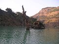
- Marshyandi River – The Marshyandi River flows north to south in the east of Besishahar Municipality. It is one of the branches of Gandaki River. The Marshyandi Bridge over the river connects eastern Lamjung. It is located in Besishahar Municipality – 2 – Udipur, Lamjung.
- The First Royal Palace Of Lamjung – It is also called Lamjung Durbar. It is the birthplace of the royal family of Lamjung in 1663 AD. Kalu Shah was the first king. It is also the place where King Yesho Bramha Shah, the founder of the Shah dynasty in Nepal, ruled the small principality of Lamjung. This palace was the capital of Lamjung. This palace stands in Gaunshahar.
-
 Painting of Lamjung Durbar at Gaunshahar

- Gaikhure Jharana – It is located in Besishahar Municipality – 2 – Udipur.
-
 Gaikhure Jharana at Gaikhure, Udipur

- Purankot Fort – Used to protect the kingdom of Lamjung. Located near the ruins of Third Royal Palace of Lamjung (the summer home for the royalty).
- Royal Bath – "Tindhara" meaning three taps, is the mineral spring where the royalty bathed.
- Hadkhode Dada – The "Bone Hill", was considered a very dangerous place many cattle have died there. Still a place frequented by many eagles.
- Sutkeri Dunga – The strongest woman in Gaunshahar was said to have placed this very large stone here while pregnant.
- Dare Gauda – A cliff that the Gorkha's army scaled, using long ladders to attack Gaunshahar, burning many houses in the village.
- Middle Marshyandi Hydro Electricity – 70-Megawatt Mid-Marshyangdi Hydroelectricity Project (MMHEP), the second largest hydropower project in the country has started operation from 14 December 2008. PM Pushpa Kamal Dahal (Prachanda) had inaugurated the project. The project was started in June 2001 with joint investments of the Government of Nepal, Germany and Nepal Electricity Authority. It is located in Besishahar Municipality – 2 – Phaliyasanghu, Udipur.
- Karpureshwar Mandir – A religious place for the Hindus. It is the place where people go to worship lord Mahadeva.
-
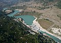 Middle Marshyandi Hydro Electricity Dam at Phaliyasanghu, Udipur

Religious and cultural landmarks
[edit]- Lamjung Kalika Temple – It is a historical Hindu goddess temple of Lamjung District located in Gaunshahar. The big sister of the Gorkha Kalika. Open four times a year during festivals (Badha Dashain, Chaitre Dashin, Shree Panchami and Nuwai).
-
 Lamjung Kalika at Gaunshahar

- Tilanagi Shivlaya Temple – Holy place to celebrate Shivaratri. Its the centre to perform Eastern Civilization Rituals of Puranakot and Duradanda Area. Located at the bank of Kirenche and Tilanagi rivers.* Udipur Kalika Temple – It is a Hindu goddess temple of Lamjung District located in Besishahar Municipality – 1 – Udipur, Lamjung. Udipur Kalika is a picnic spot in Lamjung.
-
 Udipur Kalika Temple at Udipur

- Chandimai Temple – On the seventh day of Bada Dashain, two priest from Gaunshahar travel to Besisahar to steal fruits and flowers and carry back up to this temple. While a parade of villagers and priests carrying a statue of Phulpati go down from the Royal Palace to meet the "thief priests".
- Bhimsen Temple – It is located in Besishahar Municipality – 10 – Besishahar Lamjung
-
 Bhimsen Temple at Besishahar

Educational and institutions
[edit]- Marsyangdi Multiple Campus – Marshyangdi Multiple Campus (MMC), established in 1990 (2047 B.S.)[9]
- Lamjung Skill Development Foundation (LSDF) Campus – A vast number of adolescents and youth of Nepal are out of the school system as they have been left-out or pushed-out of the school for various reasons and often found to be at the center of the vicious cycle as being either the cause or effect of the decade long armed-conflict. As a strategy to work in economic peace building a group of committed professionals with the support from Swiss-Nepal Society (SNS) and DIGA foundation of Switzerland, has established the Lamjung Skill Development Foundation (LSDF) Campus at Besishahar Municipality-4 Gairi, Lamjung. LSDF in its effort to provide a new life to marginalized youth is committed to provide market based practical oriented high-quality vocational/technical skills to the out-of-school youth so that they can be employed or self-employed after completion of their training. The Campus also aims at being a vehicle for rural reconstruction in the region. The campus opened its doors in summer 2008 with the two first long-term courses in civil construction and carpentry. Additional trades (electronic and mechanical) will be implemented step by step. Additional to the regular long-term courses, the campus regularly hosts short-term trainings according to the local needs. Among others, SNS-supported trainings for goat rearing, off-season vegetable and citrus fruits were carried out in close co-operation with local partners.[10]
- Lamjung Higher Secondary School
- Marsyangdi Higher Secondary School
- Jana Vikas Higher Secondary School
- Ex-Army Boarding Higher Secondary School
- Vidhya Bikas Higher Secondary School
- Earthly Paradise Higher Secondary School
- Shree Jana Kalyan Secondary School
- Land Star English School
- New Vision Montessori School
-
 Shree Jana Kalyan Secondary School Udipur

Hospitals
[edit]- Lamjung District Community Hospital (LDCH) – Since 2001 LDCH has been running under the management of Human Development Community Services (HDCS) with the support of the Government of Nepal. From a 15-bed hospital, LDCH now has 60 beds as well as a range of services, a study from the World Bank quoted Lamjung Hospital as being a "model hospital in Nepal."[11]
- Besishahar Hospital & Research Center – It is located in Besishahar Bazar.
- Besishahar Dental hospital – It is located in Besishahar Bazar.
- Lamjung Polyclinic – It is located in Besishahar Bazar.
- Lamjung Eye Clinic – It is located in Besishahar Bazar.
- Lamjung Model Hospital – It is located in Besishahar Bazar.
2015 earthquake
[edit]The town shook during earthquake on 25 April 2015. Houses made of mud collapsed, while those made of concrete survived. There were no visible cracks on buildings. There was little damage. The town largely escaped the devastation suffered in other places in Nepal.[12][13][14]
Gallery
[edit]-
 View of Besishahar from Gaunshahar.
 -
 View of Besishahar from Hiletaksar.
 -
 View of Besishahar
 -
 View of Aakase Vhir
 -
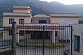 C.D.O Office
 -
 MMHE view from Udipur
 -
 MMHE Dam
 -

-
 Boating in MMHE Dam
 -
 View of Besishahar from Helicopter


See also
[edit]References
[edit]- ^ "Lamjung District". District Coordination Committee Lamjung. Retrieved 15 September 2014.
- ^ "Population & Ward Division Of Besishahar Municipality". District Development Committee Lamjung. Retrieved 15 September 2014.
- ^ "Nepal Census 2011" (PDF). Archived from the original (PDF) on 24 January 2013. Retrieved 3 September 2016.
- ^ "Jaimini (Municipality, Nepal) - Population Statistics, Charts, Map and Location". www.citypopulation.de. Retrieved 9 February 2024.
- ^ "Marshyangdi FM". Marshyangdi FM. Retrieved 15 May 2014.
- ^ "Radio Lamjung". Radio Lamjung. Retrieved 18 May 2014.
- ^ "Radio Chautari". Radio Chautari. Retrieved 20 May 2014.
- ^ "All Lamjung News". All Lamjung News. Retrieved 25 May 2014.
- ^ "Marshyangdi Multiple Campus". Marshyangdi Multiple Campus. Archived from the original on 6 September 2018. Retrieved 4 June 2014.
- ^ "Lamjung Skill Development Foundation". Lamjung Skill Development Foundation. Retrieved 8 June 2014.
- ^ "Lamjung District Community Hospital". Human Development Community Services (HDCS). Retrieved 18 June 2014.
- ^ Khan, Hamza (1 May 2015). "Nepal Earthquake: Death toll crosses 5,000, but only 4 die at epicentre". The Indian Express. The Indian Express. Archived from the original on 1 May 2015. Retrieved 3 September 2016.
- ^ "West Dorset couple who survived Nepal earthquake staying on to help in the aftermath". Dorset ECHO. 30 April 2015. Archived from the original on 1 May 2015. Retrieved 1 May 2015.
- ^ Bayley, Jon (29 April 2015). "Former Tavistock teacher recalls Nepal quake fear". Western Morning News. Western Morning News. Archived from the original on 1 May 2015. Retrieved 3 September 2016.

External links
[edit]Besishahar
View on GrokipediaHistory
Etymology and early settlement
The name Besishahar derives from the Nepali terms besi, denoting the lowland or base of a hill, and sahar, meaning city or town, collectively translating to "the town at the base of the hill," reflecting its geographical position in the Marsyangdi Valley.[1] The region of present-day Besishahar exhibits evidence of ancient human settlement by the Tamu (Gurung) ethnic group, with archaeological ruins such as those at Kohla Sonpre Toh indicating early Tamu/Gurung habitation dating back centuries.[8] These sites, linked to pre-Shah era rulers like the Ghale kings who first settled in areas such as Kohla Sonthar, underscore the area's role as one of the earliest Gurung settlement zones in the Himalayas.[9][10] Lamjung District, encompassing Besishahar, served as the origin of the Shah dynasty's political power, with historical accounts tracing the dynasty's establishment in the region to the late 15th century under rulers like Kalu Shah, who assumed the throne around 1493.[4][11] Gaunshahar, a key ward within modern Besishahar Municipality formed in 2014, is recognized as the birthplace of early Lamjung Shah kings, including Kalu Shah in 1663 according to local traditions, marking a pivotal phase in the consolidation of local governance preceding the unification of Nepal.[12][13]Development in the 20th and 21st centuries
In the early 20th century, Besishahar remained a predominantly rural settlement within Lamjung District, characterized by subsistence agriculture and limited connectivity, as Nepal's overall infrastructure development was constrained by its mountainous terrain and centralized governance under the Rana regime until 1951.[14] Post-1951 democratic shifts and foreign aid facilitated gradual road improvements, with the Prithvi Highway's completion in 1974 enhancing access from Kathmandu to nearby Dumre, spurring secondary road networks like the Dumre-Besishahar route that boosted local trade and migration by the late 20th century.[15] These connections increased accessibility, enabling timber extraction and basic market integration but also accelerating deforestation and land use changes in surrounding areas.[14] The 21st century marked accelerated infrastructure growth, exemplified by the Middle Marsyangdi Hydroelectric Project (70 MW capacity), with construction beginning in 2003 and operations commencing in 2008, which generated employment, improved power supply to the region, and positioned Besishahar as a hub for energy-related economic activity.[16] Administrative consolidation in 2014 merged several Village Development Committees—including Besishahar, Gaunshahar, Udipur, and Chandisthan—into a single municipality, expanding its area to approximately 120.42 square kilometers and formalizing urban planning efforts amid rising population pressures.[5] Road expansions, such as proposals in 2018 to widen key arteries, aimed to accommodate urbanization but raised concerns over displacing over 500 households and eroding historical sites valued at more than NPR 20 billion.[17] Recent developments include initiatives for scientific urbanization, designating Danaiphat as a model smart city site, alongside challenges in solid waste management, where inadequate infrastructure and collection practices persist despite municipal policies.[18][19] Tourism infrastructure has expanded as Besishahar serves as the gateway for Manaslu Circuit and Annapurna treks, contributing to local revenue but straining resources like water quality and slope stability in cut areas for construction.[5][20] Remittances from foreign employment have further supported household improvements in education and housing, altering socioeconomic patterns since the early 2000s.[21]Geography
Location and topography
Besishahar Municipality serves as the district headquarters of Lamjung District in Gandaki Province, central Nepal. It is positioned in the mid-hill region along the Marsyangdi River valley, approximately 160 kilometers west of Kathmandu. The town's central coordinates are roughly 28.23°N latitude and 84.37°E longitude, placing it within a transitional zone between the southern plains and northern high mountains.[22] The elevation of Besishahar averages around 1,334 meters above sea level, with surrounding terrain varying from riverine lowlands to hill ridges exceeding 2,000 meters. The Marsyangdi River, a major tributary of the Gandaki River system, flows northward through the eastern part of the municipality, carving a fertile valley amid undulating hills composed primarily of sedimentary and metamorphic rock formations typical of the Lesser Himalayas. This riverine setting supports terraced agriculture on slopes while exposing the area to seasonal flooding risks from monsoon swells.[23][5] Topographically, the landscape features steep gradients and green hillocks interspersed with cultivated fields, reflecting the dissected plateau characteristics of Nepal's central hill belt. To the north, the terrain rises sharply toward the Annapurna massif, with visible Himalayan peaks influencing local microclimates and providing a backdrop of rugged ridges and deep gorges. Geological surveys along nearby routes indicate fault-line influences contributing to seismic activity and variable soil stability, underscoring the dynamic nature of the region's geomorphology.[24][25][5]Climate
Besishahar features a humid subtropical climate (Köppen Cwa) with pronounced monsoon influences, typical of Nepal's mid-hills at elevations around 760 meters. The region experiences four seasons: a cool, dry winter (December–February), a warm pre-monsoon period (March–May), a hot and wet monsoon summer (June–September), and a mild post-monsoon autumn (October–November). Annual temperatures vary from lows of approximately 4°C in winter to highs exceeding 30°C during the pre-monsoon and early monsoon, with a mean annual temperature around 20–21°C based on district records from 1981–2010.[26][27] Precipitation is heavily concentrated in the monsoon season, accounting for over 80% of the annual total, which averages 2,800–3,400 mm district-wide according to data from Nepal's Department of Hydrology and Meteorology (DHM) stations in Lamjung. July is typically the wettest month, with monthly rainfall often exceeding 300–400 mm and up to 28 rainy days, while November is the driest with under 5 mm and few rainy days. Winter months receive minimal rain, less than 20 mm each, supporting dry conditions conducive to fog and occasional cold waves. Trends from 1981–2010 indicate a statistically significant annual temperature increase of 0.07°C per year, with precipitation showing insignificant rises in non-winter seasons.[27][28] The table below summarizes modeled monthly climate averages for Besishahar, derived from historical reanalysis data:| Month | Avg. High (°C) | Avg. Low (°C) | Precipitation (mm) | Rainy Days (≥1 mm) |
|---|---|---|---|---|
| January | 16 | 4 | 18 | 2.3 |
| February | 18 | 6 | 20 | 2.3 |
| March | 24 | 9 | 13 | 1.9 |
| April | 28 | 13 | 13 | 2.7 |
| May | 31 | 17 | 41 | 6.1 |
| June | 30 | 19 | 147 | 13.4 |
| July | 27 | 19 | 272 | 20.9 |
| August | 25 | 18 | 224 | 19.4 |
| September | 24 | 17 | 137 | 12.4 |
| October | 22 | 13 | 36 | 3.4 |
| November | 19 | 9 | 5 | 0.6 |
| December | 17 | 6 | 10 | 1.3 |
Demographics
Population trends
The population of Besishahar Municipality stood at 39,356 according to the 2011 Nepal census.[29] By the 2021 census, this figure had declined to 38,232, representing a net decrease of 1,124 residents over the decade, or an average annual growth rate of approximately -0.3%.[30] [3] This trend aligns with patterns observed in many Nepalese hill districts, where rural-to-urban migration and international labor emigration predominate.[31]| Census Year | Population | Annual Growth Rate (prior decade) |
|---|---|---|
| 2011 | 39,356 | - |
| 2021 | 38,232 | -0.3% |
Ethnic and linguistic composition
According to the 2021 National Population and Housing Census, Besishahar Municipality has a total population of 38,232, with a diverse ethnic composition dominated by two nearly equal groups: Gurung comprising 25.5% and Kshetri (Chhetri) 25.1%.[35][30] Brahman-Hill accounts for 9.2%, reflecting the presence of Indo-Aryan hill communities.[35] Other notable ethnic groups include Tamang (8.3%), Bishwokarma (7.2%), Mijar (5.7%), Newar (4.8%), Pariyar (4.7%), Magar (3.5%), and Gharti/Bhujel (1.4%), alongside smaller populations of various Dalit, Janajati, and other castes.[35] This distribution highlights a blend of Tibeto-Burman ethnicities (e.g., Gurung, Tamang, Magar) and Indo-Aryan groups (e.g., Kshetri, Brahman), typical of central Nepal's hill regions, though Besishahar's urban status as district headquarters fosters greater intermingling compared to rural wards.[35]| Ethnic Group | Percentage |
|---|---|
| Gurung | 25.5% |
| Kshetri | 25.1% |
| Brahman-Hill | 9.2% |
| Tamang | 8.3% |
| Bishwokarma | 7.2% |
| Mijar | 5.7% |
| Newar | 4.8% |
| Pariyar | 4.7% |
| Magar | 3.5% |
| Gharti/Bhujel | 1.4% |
Economy
Agriculture and local trade
Agriculture in Besishahar Municipality relies on smallholder subsistence farming adapted to the hilly topography of Lamjung District, with terraced cultivation of staple cereals such as rice, maize, millet, wheat, barley, and buckwheat predominating in the mid-hills.[37] Cash crops, including large cardamom—a major export-oriented spice—contribute significantly to household incomes, with Lamjung District producing 380 metric tons in the fiscal year 2022/23 and generating approximately 200 million Nepalese rupees for farmers through sales.[38] Vegetable production, encompassing crops like cauliflower, cabbage, tomatoes, and potatoes, supports both local consumption and market sales, with recent surveys of 35 growers in Besishahar indicating partial adoption of integrated pest management practices to address pest challenges and improve yields.[39] Local trade revolves around agricultural commodities exchanged in Besishahar's central market and nearby bazaars, such as Udipur, where farmers sell produce directly or through cooperatives. A vegetable marketing cooperative operates a 'Farmer's House' in Besishahar to streamline sales of locally grown vegetables, reducing post-harvest losses via improved transport like the 'Agricultural Ambulance' scheme launched in May 2025 for delivering organic fruits and vegetables.[40] Cardamom trading links farmers to regional buyers, with technological adoption studies in Besishahar highlighting efforts to enhance processing and market access for this high-value crop.[41] The Nepali Army Institute of Agricultural Sciences, located in Besishahar-02, provides extension services and research to bolster these activities, focusing on sustainable practices amid Nepal's broader hill agriculture emphasis on maize and wheat alongside livestock integration.[42][43]Tourism and rural development
Besishahar functions as the primary gateway to the Annapurna trekking region, serving as the starting point for the Annapurna Circuit and other Himalayan trails, which draws trekkers seeking access to the Marsyangdi River valley and views of the Annapurna and Manaslu mountain ranges.[44][45] The town's location facilitates visits to natural sites such as Gaikhure Jharana waterfall and the Middle Marsyangdi Hydroelectric Dam, where recreational boating occurs, alongside cultural landmarks including Udipur Kalika Temple and Bhimsen Temple.[5] These attractions support a tourism sector centered on trekking, river scenery, and local ethnic experiences among Gurung and Magar communities.[45] Tourism contributes to rural development in Besishahar Municipality through initiatives promoting homestays and community-based operations, which generate supplementary income for rural households in surrounding wards.[46] The Nepal Tourism Board has collaborated with the Lamjung District Tourism Development Committee since at least 2023 to enhance rural tourism infrastructure, targeting areas with scenic rural lifestyles to attract visitors interested in authentic village experiences and natural beauty.[46] This approach aims to foster economic diversification beyond agriculture, though challenges persist, including inadequate waste management systems strained by increasing tourist numbers.[47] Local organizations like the Rural Community Development Center (RCDC) Nepal operate in Besishahar to integrate tourism with broader livelihood programs, emphasizing sustainable practices that support rural empowerment.[48] Rural tourism development in Lamjung District, including Besishahar, leverages the area's ethnic diversity and topography to promote cultural preservation alongside economic gains, with potential for homestay expansions to bolster household revenues.[46] However, realization of these benefits depends on addressing infrastructural gaps, as evidenced by ongoing district-level planning efforts.[46]