

Community hub
Recent from talks
Contribute something
Nothing was collected or created yet.
Binyamina-Giv'at Ada
View on Wikipedia
Binyamina-Giv'at Ada (Hebrew: בנימינה-גבעת עדה) is a town in the Haifa District in northern Israel. It is the result of the 2003 merger between the two local councils of Binyamina and Giv'at Ada. In 2022, its joint population was 15,634.[3] Before the merger, the population of Binyamina was 6,607.
Key Information


History
[edit]Binyamina
[edit]
Binyamina was founded in 1922. At first, the proposed name for the Moshava was "Tel Binyamin", but as the nearby British railway station was called Binyamina railway station, which itself was named after the Baron Edmond Benjamin James de Rothschild, the inhabitants chose to call it Binyamina.[4] Binyamina was founded on PICA land by members of the Third Aliyah and people from the neighboring Zikhron Ya'akov. According to a census conducted in 1922 by the British Mandate authorities, Binyamina had a population of 153 inhabitants, consisting of 137 Jews, 13 Muslims and 7 Christians.[5] In 1946 the Betar Tower and Stockade settlement (which was relocated multiple times) "Nahalat Jabotinsky", named after Ze'ev Jabotinsky became a part of the Binyamina municipality.[6][7][8] The original economy of the village was citrus-based and a jasmine refining factory for the French perfume industry.[9] In 1947, Binyamina had a population of 2000.[10]
-
 Binyamina 1928
 -
 Binyamina 1934
 -
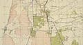 Binyamina 1942 1:20,000
 -
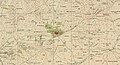 Giv'at Ada 1942 1:20,000 (bottom left)
 -
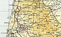 Binyamina & Giv'at Ada 1945 1:250,000


Giv'at Ada
[edit]Giv'at Ada, 'Ada Heights', named for Baron Edmond James de Rothschild's wife Adelheid/Adélaïde (Ada), was established in 1903 by eight families from Zikhron Ya'akov.[11] Giv'at Ada was established as an agricultural Moshava. The main farming branches were field crops and vegetables, and later grapes.[11]
Merger
[edit]The two local councils, Binyamina and Givat Ada, were merged into one authority as part of an initiative by the Ministry of the Interior regarding the unification of local authorities in Israel. The unification was carried out in 2003 as part of the plan for the revival of the Israeli economy. From the beginning, there was an intention to unite the three settlements into one authority: Zichron Ya'akov, Binyamina, and Givat Ada.[12] Finally it was decided in the Knesset on July 31, 2003, to unify Binyamina and Givat Ada only.[13]
On 13 October, 2024, a Hezbollah drone attacked a military base of the Golani Brigade near the town, killing 4 IDF personnel and injuring 67 people, with several critically wounded.[14]
Economy
[edit]
The area is home to both the Binyamina Winery, producers of 2.8 million bottles of wine annually, and the Tishbi Winery, founded by Yonathan Tishbi in 1985. As of 2009, Tishbi produced approximately one million bottles per year.[15][16] Plans have been drawn up to build a 150-acre (0.61 km2) wine park on the slopes between Binyamina and Zichron Ya'akov to promote wine tourism in Israel.[17]
Shuni
[edit]The Jabotinsky Park at Shuni contains a Roman theatre with an adjacent semicircular pool used during the Graeco-Syrian pagan Maiumas water festival of Roman Syria,[18] and buildings of the former Arab Palestinian hamlet of Khirbat al-Shuna.

The ancient village of Kefar Shumi or Shami stood close to the springs at the foot of the Carmel ridge whose waters were sent to Caesarea Maritima by aqueduct.[19] In 1902, it was known in Arabic as Shuni and Mayumas.[19]
Transport
[edit]The busy Israel Railways Binyamina Railway Station is the last stop on the Binyamina-Tel Aviv suburban line and a transfer point on the Tel Aviv-Haifa intercity line, which makes it a transportation hub for the area. A direct non-stop train from Binyamina reaches Tel Aviv or Haifa in 30 minutes.
Population
[edit]According to the data of the Central Bureau of Statistics, as of the end of January 2023 (estimate), 16,343 residents live in Binyamina-Givat Ada (124th place in the ranking of local authorities in Israel). The population is growing at an annual growth rate of 1.8%. The percentage of those who earned a Bagrut certificate among 12th-grade students in the year 2020-2021 was 88.1%. The average monthly salary of an employee during the year 2019 was 13,552 NIS (national average: 9,745 NIS).[20]
Notable residents
[edit]Binyamina is the birthplace of the Israeli songwriter Ehud Manor,[21] and is referenced in a number of his songs. It is also the birthplace of the 12th Israeli Prime Minister Ehud Olmert, and basketball player Adi Gordon.[22] Amongst its current residents are famous TV actor Lior Halfon,[23] former Maccabi Haifa F.C. Maor Buzaglo[24]
Twin towns – sister cities
[edit]References
[edit]- ^ "תוצאות הבחירות המקומיות 2024 סיבוב שני". www.themarker.com (in Hebrew). 11 March 2024. Retrieved 10 May 2024.
- ^ a b "Regional Statistics". Israel Central Bureau of Statistics. Retrieved 11 August 2025.
- ^ "General Information (Binyamina-Givat Ada)".
- ^ בנימינה - הכפר על שם הנדיב הידוע (in Hebrew). מועצה מקומית בנימינה. pp. 68–71.
- ^ "Palestine Census ( 1922)".
- ^ בנימינה - הכפר על שם הנדיב הידוע (in Hebrew). מועצה מקומית בנימינה. pp. 229–231.
- ^ "Olmert speech at Mishmar Hacarmel". israelforeignaffairs.com. Retrieved 2 March 2023.
- ^ "encyclopaedia judaica" (PDF).
- ^ [1]
- ^ Jewish National Fund (1949). Jewish Villages in Israel. Jerusalem: Hamadpis Liphshitz Press. p. 24.
- ^ a b "Women on the Map". Archived from the original on 21 July 2011. Retrieved 24 August 2010.
- ^ "הצעת חוק התכנית להבראת כלכלת ישראל 2003" (PDF). 2003.
- ^ "חוק התכנית להבראת כלכלת ישראל (תיקוני חקיקה להשגת יעדי התקציב והמדיניות הכלכלית לשנות הכספים 2003 ו-2004) (מס' 2) – ויקיטקסט". he.wikisource.org (in Hebrew). Retrieved 2 March 2023.
- ^ "Unprecedented Lebanese drone attack wounds 40 near Binyamina, four in critical condition". The Jerusalem Post. 13 October 2024. ISSN 0792-822X. Retrieved 13 October 2024.
- ^ "About Us". Binyamina Wines. Archived from the original on 17 October 2010.
- ^ Rogov, Daniel (12 August 2009). "Wine and Spirits / Family fortune". Haaretz.
- ^ "Israel seeks to become wine tourism destination". Globes. 17 January 2008. Archived from the original on 5 October 2008. Retrieved 17 January 2008.
- ^ Di Segni, Leah (2023). Two Greek Inscriptions on Mosaics from the Theater at Shuni (PDF), in Atiqot 110, pp. 159-172. Accessed 15 May 2024.
- ^ a b Negev, Avraham; Gibson, Shimon, eds. (2001). "Maiumas (c); Shuni-Mayumas". Archaeological Encyclopedia of the Holy Land. New York and London: Continuum. pp. 309, 468–469. ISBN 0-8264-1316-1.
- ^ "הלמ"ס נתוני בנימינה 2020" (PDF). 2020.
- ^ "Ha'aretz Online: Thousands attend the funeral of lyricist". Archived from the original on 25 October 2005. Retrieved 26 March 2009.
- ^ "עדי גורדון". www.makorrishon.co.il. Retrieved 2 March 2023.
- ^ "אשתו של ליאור כלפון בווידוי מרגש: כך ניצחתי את התקפי החרדה והדיכאון". mynetbatyam (in Hebrew). 24 October 2021. Retrieved 2 March 2023.
- ^ "מאור בוזגלו עוזב את העיר". mynetholon (in Hebrew). 6 November 2017. Retrieved 2 March 2023.
- ^ Gilad, Moshe (6 September 2007). "Choose Your Family". Haaretz. Retrieved 23 April 2019.

Binyamina-Giv'at Ada
View on GrokipediaGeography
Location and Administrative Status
Binyamina-Giv'at Ada is a local council situated in the Haifa District of northern Israel, within the Bik'at HaNadiv valley at the foothills of the Carmel Mountains.[1] The area features a pastoral landscape of vineyards, orchards, agricultural fields, and flowing streams, with views extending toward the Mediterranean Sea.[1] Its geographic coordinates are approximately 32°31′N 34°57′E.[6] Administratively, Binyamina-Giv'at Ada functions as a single local council encompassing the merged communities of Binyamina and Giv'at Ada, which were consolidated in 2003 to form the unified municipality while preserving distinct community identities.[1] The council covers an area of 24.40 square kilometers and falls under the jurisdiction of the Haifa District.[7]Terrain and Climate
Binyamina-Giv'at Ada occupies gently rolling terrain on the western foothills of the Menashe Plateau, transitioning from the coastal plain to low hills, with elevations ranging from near sea level in adjacent valleys to peaks around 100 meters. The average elevation across the locality is approximately 32 meters above sea level, facilitating drainage and supporting intensive agriculture on slopes suitable for terracing. Soils predominantly consist of fertile clay-rich Vertisols, such as Pellic Vertisols in areas like Shuuni Park, which exhibit high shrink-swell properties and retain moisture well, ideal for crops including vineyards, citrus orchards, and field vegetables.[8][9][10] The region experiences a Mediterranean climate with hot, arid summers and mild, rainy winters, classified as Csa under the Köppen system. Annual precipitation averages 500-600 mm, concentrated between October and April, with negligible rainfall from May to September; nearby Haifa records about 541 mm yearly, reflecting similar patterns influenced by Mediterranean frontal systems. Mean annual temperatures hover around 19-20°C, with July-August highs often exceeding 30°C and January lows dipping to 8-10°C, enabling a long growing season but requiring irrigation during dry periods.[11][12][13]History
Origins of Binyamina
Binyamina was established in 1922 as an agricultural settlement during the British Mandate period in Palestine.[2] It was founded primarily by immigrants from the Third Aliyah (1919–1923) alongside descendants of First Aliyah (1882–1903) settlers from nearby communities such as Zichron Ya'akov and Givat Ada.[14] The settlement was initiated on land owned by the Palestine Jewish Colonization Association (PICA), an organization established to manage properties acquired by Baron Edmond James de Rothschild for Jewish agricultural development.[2] The name Binyamina derives from the Hebrew name of Baron Edmond de Rothschild, known as "Binyamin" in Jewish tradition, reflecting his pivotal role in funding early Zionist settlements through land purchases from Ottoman landowners.[2] Initially proposed as "Tel Binyamin," the name was shortened to align with the adjacent British railway station, facilitating practical identification. Early residents focused on citrus cultivation, leveraging the fertile coastal plain soils, with the 1922 census recording 137 Jewish inhabitants comprising about 90% of the local population.[2] By the mid-1920s, the settlement expanded to incorporate the site of Khirbat al-Shuna, a small Arab hamlet or ruin previously known as al-Shuna al-Yahudiyya under early Jewish development, marking the integration of prior land uses into the growing moshav framework.[15] This establishment occurred amid broader Zionist efforts to redeem and cultivate underutilized tracts, supported by PICA's systematic acquisition and allocation of over 25,000 hectares for such ventures.[16]Founding of Giv'at Ada
Giv'at Ada was founded in 1903 as an agricultural moshava by eight families who had previously resided in the nearby settlement of Zikhron Ya'akov.[2] The initiative reflected the broader pattern of early 20th-century Jewish settlement expansion in Ottoman Palestine, supported by philanthropic efforts to establish self-sustaining farming communities on purchased land.[17] The settlement's name derives from Adelaide (Ada) de Rothschild, wife of Baron Edmond James de Rothschild, whose funding and guidance underpinned many pioneer colonies in the region, including Zikhron Ya'akov itself.[2] These families, numbering a small pioneer group, selected the site for its potential agricultural viability amid the coastal plain's fertile soils, though initial plots were acquired through the Jewish Colonization Association or similar bodies affiliated with Rothschild's enterprises.[4] From inception, the economy centered on field crops and vegetable cultivation, marking a shift from the grape-focused viticulture of Zikhron Ya'akov toward diversified farming suited to the local terrain.[2] The founders confronted immediate hardships, including encirclement by hostile Arab villages, rudimentary infrastructure, and economic precarity without established markets or irrigation systems, compelling reliance on manual labor and communal resilience against both environmental adversities and security threats from surrounding populations.[18] Despite these constraints, the settlement endured, with early structures serving multiple purposes such as housing, storage, and basic education, foreshadowing gradual expansion into citrus and later viticulture by the 1920s.[19]Mandate Era Developments and Security Challenges
During the British Mandate, Binyamina, established in 1922 by residents from nearby Zikhron Ya'akov and Giv'at Ada—primarily families from the First Aliyah alongside new immigrants—expanded as a cooperative moshav focused on mixed farming, including citrus cultivation and field crops, amid efforts to reclaim marshy lands in the Emek Hefer valley.[4] The settlement's growth aligned with broader Zionist land acquisition initiatives, such as those by the Jewish National Fund, which targeted the Wadi al-Hawarith (later Emek Hefer) region for drainage and agricultural development starting in the late 1920s.[20] By the early 1930s, infrastructure improvements, including proximity to the coastal railway line, facilitated economic viability, though initial challenges included malaria-prone swamps and limited water resources. Giv'at Ada, founded in 1903 on land purchased by the Jewish Colonization Association and named for Ada de Rothschild, saw continued consolidation during the Mandate as a moshavah emphasizing orchards and vineyards, with eight founding families from Zikhron Ya'akov transitioning from subsistence to export-oriented agriculture.[2][21] Mandate-era policies under the 1922 census recorded modest populations—Binyamina with 153 residents, predominantly Jewish—but spurred incremental expansion through cooperative models, reflecting Zionist emphasis on self-sufficiency amid British restrictions on land sales post-1939 White Paper.[22] Security challenges intensified with Arab opposition to Jewish land purchases and settlement, exemplified by violent clashes in Emek Hefer over Wadi al-Hawarith tracts, where Arab tenants resisted eviction and cultivation by Jewish groups, halting development amid Mandate-era disputes.[23] The 1936–1939 Arab Revolt brought widespread attacks on Jewish settlements, including road ambushes and sabotage near Haifa district outposts like Binyamina, prompting Haganah fortifications and stockade-tower defenses across the valley to protect isolated moshavim.[24] By the 1947–1948 civil war phase, the region hosted Irgun training camps near Binyamina and Giv'at Ada, heightening local tensions, while Jewish paramilitary actions, such as Lehi's March 31, 1948, train mining near Binyamina killing 40 Arabs, underscored escalating intercommunal violence amid British withdrawal.[25][26]Statehood, Growth, and Merger
Following Israel's declaration of independence on May 14, 1948, Binyamina integrated into the nascent state's administrative framework, benefiting from the cessation of Mandate-era restrictions and the stabilization of Jewish settlements in the region after the 1947–1949 war. The community, previously operating as a moshav shitufi, was formally established as an independent local council in 1949, enabling localized governance over municipal services, infrastructure, and land use amid national efforts to consolidate rural Jewish areas.[27] Post-independence growth was driven by agricultural intensification, particularly in citrus cultivation and viticulture, alongside Israel's broader immigration influx, which saw the national Jewish population double between 1948 and 1951. Binyamina's population expanded from an estimated 2,800 residents in the mid-1950s to over 3,000 by the late 1950s, reflecting steady influxes of new settlers and families attracted to its fertile Menashe Plateau location and rail connectivity via Binyamina station, a key north-south transport node upgraded under state investment. By the 1970s and 1980s, further development included residential expansions and economic diversification, with the population reaching approximately 5,000–6,000 by the early 2000s, supported by national policies promoting peripheral growth.[28] Giv'at Ada, similarly transitioning to statehood, experienced parallel demographic increases as a cooperative moshav, growing from modest post-war numbers to around 4,000 residents by the merger period, fueled by cooperative farming successes and proximity to urban centers like Hadera. In 2003, the Israeli Ministry of the Interior facilitated the merger of Binyamina and Giv'at Ada into a unified local council named Binyamina-Giv'at Ada, aiming to enhance administrative efficiency, resource sharing, and service delivery for small rural councils amid fiscal pressures. The combined entity started with roughly 11,000 inhabitants, preserving the distinct moshav identities of each while centralizing functions like education and utilities; this consolidation aligned with broader reforms reducing the number of fragmented local authorities in Israel.[2][1]Governance
Merger and Administrative Evolution
Binyamina-Giv'at Ada was established as a unified local council in 2003 through the administrative merger of the previously independent local councils of Binyamina and Giv'at Ada, both classified as moshavot (agricultural villages).[1] This consolidation occurred amid a national reform under Israel's 2003 economic recovery plan, which mandated the amalgamation of 23 local authorities into 11 larger entities to enhance operational efficiency, reduce administrative redundancies, and address fiscal challenges in local governance.[29] The merger preserved the historical and cultural identities of Binyamina, founded in 1922, and Giv'at Ada, established in 1903, while integrating their services, planning, and leadership under a single municipal framework.[1] The process aligned with legislative changes that facilitated voluntary and compulsory unifications, aiming to create viable entities capable of managing infrastructure, zoning, and community services more effectively. Post-merger, the new council managed a combined area emphasizing rural preservation alongside development, with governance transitioning to a unified council headed by a mayor and elected body. No significant boundary expansions or further mergers have occurred since, though proposals for broader regional consolidations—such as with nearby Zichron Ya'akov—have been discussed and resisted by local stakeholders to maintain autonomy.[30] Administrative evolution has centered on internal adaptations to population pressures and economic shifts, including zoning reforms for housing expansion. By 2020, the council pursued plans to double its population through sustainable development, reflecting growth from approximately 9,000 residents immediately post-merger to over 15,000 by the early 2020s, without altering its local council designation.[4] Current leadership, under Mayor Ittai Weissberg, prioritizes fiscal stability, educational infrastructure, and environmental policies, operating as a standard Israeli local council with authority over local taxation, utilities, and planning within the Haifa District.[1]Current Local Leadership and Policies
Gil Chenaniah has served as head (rosh moatza) of the Binyamina-Giv'at Ada Local Council since winning the February 2024 municipal elections, succeeding Ittai Weisberg who held the position from 2017 until the vote.[31] The council's 13-member body prioritizes preserving the area's rural moshavot heritage amid growth pressures, with Chenaniah emphasizing sustainable development, community education, and infrastructure upgrades in his first year.[32] Shay Kadam serves as the council's CEO (manaklal), overseeing administrative operations including budgeting and departmental coordination.[31] Key policies under Chenaniah include opposition to expansive urban projects that could erode the locality's semi-rural character, such as rejecting proposals for 1,800 housing units and commercial space in northwest Binyamina despite approval by the National Planning Committee in June 2025, citing risks of overburdening infrastructure and transforming the area into an "urban cemetery."[33] Similarly, the council has resisted converting agricultural lands like the Binyamina winery site into residential developments, advocating for preservation of historic and economic assets while permitting limited zoning for renewal.[34] These stances reflect a broader commitment to controlled expansion, including a 20-year outline plan initiated under prior leadership but continued, aiming to double population to around 30,000 by enhancing pedestrian-friendly zones and railway integration without sacrificing green spaces.[4] Educational and transport initiatives form another pillar, with Chenaniah promoting public awareness campaigns for youth on sustainable mobility, including expanded access to public transit cards ("Rav-Kav for All") to reduce car dependency in the Haifa District periphery. Fiscal policies focus on budget stabilization amid national cuts, with the 2025 allocation emphasizing workforce standards, departmental efficiencies, and strategic learning from peer municipalities like Pardesiya to foster innovation in services.[35] Overall, leadership stresses open governance, resident input, and balancing economic vitality—rooted in agriculture and tourism—with environmental safeguards, though tensions persist over state-driven housing mandates.[1]Demographics
Population Trends and Statistics
As of the 2021 estimate from Israel's Central Bureau of Statistics, Binyamina-Giv'at Ada had a population of 16,075 residents, distributed across an area of 24.40 square kilometers, yielding a population density of approximately 659 persons per square kilometer.[3] The locality's annual population growth rate averaged 1.5% between 2013 and 2021, reflecting steady expansion driven by natural increase and internal migration within Israel rather than significant international inflows.[3]| Year | Population |
|---|---|
| 1995 | 4,100 |
| 2000 | 6,000 |
| 2008 | 12,000 |
| 2014 | 14,267 |
| 2021 | 16,075 |