Respect all members: no insults, harassment, or hate speech.
Be tolerant of different viewpoints, cultures, and beliefs. If you do not agree with others, just create separate note, article or collection.
Clearly distinguish between personal opinion and fact.
Verify facts before posting, especially when writing about history, science, or statistics.
Promotional content must be published on the “Related Services and Products” page—no more than one paragraph per service. You can also create subpages under the “Related Services and Products” page and publish longer promotional text there.
Do not post materials that infringe on copyright without permission.
Always credit sources when sharing information, quotes, or media.
Be respectful of the work of others when making changes.
Discuss major edits instead of removing others' contributions without reason.
If you notice rule-breaking, notify community about it in talks.
Do not share personal data of others without their consent.
The Cincinnati Subway is a partially completed rapid transit system beneath the streets of Cincinnati, Ohio. Although the system only grew to a little more than 2 miles (3.2 km) in length, its derelict tunnels and stations make up the largest abandoned subway tunnel system in the United States. Construction began in the early 1900s as an upgrade to the Cincinnati streetcar system, but was abandoned due to escalating costs, the collapse of funding amidst political bickering, auto industry lobbying against public transit projects, and the Great Depression during the 1920s and 1930s.
In 1928, the construction of the subway system in Cincinnati was indefinitely canceled, and there are no plans to revive the project. Numerous efforts and proposals have been made since the 1930s to repurpose the existing tunnels for transportation projects, infrastructure, storage facilities, and commercial or community hubs.
Rapid transit was seen as the solution for downtown congestion in Cincinnati during the first quarter of the 20th century. Six million dollars were allocated for the project, but construction was delayed due to World War I. Unexpected post-war inflation doubled the cost of construction, so the project could not be finished at the original estimated price.
Various attempts to use the tunnels for mass transit have been unsuccessful. Political squabbling, the Great Depression, World War II, automaker lobbying and negative news media publicity have contributed to the failure of the proposals.[1] Today, many Cincinnatians are unaware of the tunnels beneath them.[2]
From 1825 to 1920 the Miami and Erie Canal divided Cincinnati's residential neighborhood of Over-the-Rhine from the business district of downtown.[3][4] The canal was used to transport goods and people from the Great Lakes to the Ohio River and subsequently the Mississippi River via Cincinnati, until the popularity of railroads caused it to become disused. The canal then became very polluted due to people dumping trash in it and using it as a sewer.[3] The canal became unprofitable by 1856[3] and was abandoned by the city in 1877.[1]
On September 15, 1883, a weekly Cincinnati magazine called The Graphic proposed that the "dead old ditch" be used to provide an unobstructed route for a subway system, with a large boulevard above.[5]
Cincinnati began adopting electric streetcars in 1888;[5] this soon became the main form of public transportation.[6] During this period Cincinnati was one of the seven most populous US cities[3] and had a rate of growth and economic importance that was similar to that of New York City and Chicago.[1] The slow streetcars shared the crowded streets with horse-drawn carriages and people, and collided with the first automobiles on an almost daily basis.[6] It was not unusual for trips between downtown and the surrounding suburbs to take 45 minutes to an hour.[7] Despite having 222 miles (357 km) of streetcar tracks, the city found itself in a growing traffic nightmare.[6]
Another newspaper, the Cincinnati Commercial Tribune, gave encouraging words to the public and said "We believe that the city we love, our home, is at the turning point, and that with the coming of Rapid Transit we will have the beginning of a Greater, More Prosperous, Healthier and Happier Cincinnati. We believe that a Vote for the Loop is a Vote for the best interests of all of us, and it is with pride that we state that every newspaper in the city is for the Loop, and practically all of the Business organizations as well as the Trades Unions." This helped the project win the fight in the polls when the people of Cincinnati enthusiastically passed bill to start construction.[8]
In 1910, Henry Thomas Hunt spearheaded plans for a new rapid transit system.[9] The next year, City Council convinced the Ohio State Legislature to lease the city's portion of the canal for use as a boulevard and subway system.[3] The city hired experts who had worked on Boston's and Chicago's rapid transit systems to research the best possible implementation for Cincinnati's rapid transit system.[10] The result were four "Schemes", or proposed routes. The chosen plan—Scheme IV, modification H—looped around the city hitting the central suburbs of St. Bernard and Norwood, the eastern suburbs of Oakley and Hyde Park, and then returned into downtown.[10]
In 1916, City Council authorized a bond issue of $6 million[a] with an interest rate of 4.25 percent,[11][8] and then held a plebiscite on the rapid transit plan.[4] The bond was supposed to fund a 16 miles (26 km) subway system stretching across Cincinnati, which would, in turn, slow or even stop the decline of Cincinnati's population at the time. One advertisement in support of the subway proclaimed, "Every newspaper in the city is for the Loop, and practically all of the Business organizations as well as the Trades Unions."[8] On April 17, 1917, Cincinnati citizens voted in favor of using the bond for a Rapid Transit system, 30,165 to 14,286.[4] The system would be built as a below grade, at grade and elevated railway, with the Underground portion to be built in the Miami and Erie Canal bed through downtown, and then extend through the Mill Creek valley to St. Bernard, Norwood, Oakley.[8]
Proposed route: description from 1916 bond campaign
Follows canal bed from Walnut Street to Carthage Pike.
Exceptions – Marshall Avenue, Bates Avenue and bend south of Ludlow Avenue, for the purpose of eliminating curves in canal bed that are so sharp as to be impossible to operate at high speed.
Subway: Fourth and Walnut Street to Brighton.
Open subway: Brighton to Bates Avenue.
Open cut or fill: Bates Avenue to Crawford Station.
Necessary covered section for approaches to Boulevard.
Sassafras Street.
Brashers Street.
Ludlow Avenue.
Open surface line in canal bed: Crawford Station to Carthage Pike, except at Mitchell Avenue, where it leaves canal bed and comes level to Mitchell Avenue.
Street surface Line: Carthage Pike, Tennessee Avenue, Maple Avenue, Smith Road.
Open cut or fill along Duck Creek Road on privet right of way: Oakley Station to Lake Avenue ravine (a short distance west of Potomac Avenue).
Open cut or fill in Lake Avenue ravine from Lake Avenue ravine to Owls Nest Park.
Subway under Owl's Nest Park and Madison Road.
Tunnel under Beechwood Subdivision (Wurlitzer Property).
Concrete trestle along Ohio River bluff to Eden Park Reservoir.
Steel elevated on Third, Martin, Pearl and Walnut Streets.
Passes from elevated to subway between Third and Fourth Street on Walnut Street.
Rapid Transit with no grade crossing from Oakley Station to Crawford Station by the way of downtown district.
High speed surface line from Crawford Station to Oakley Station on north side.
However, because the United States entered World War I just 11 days earlier,[1] construction was halted because no capital issues of bonds were permitted during the war.[8][4][13]
War conditions have prompted the opinion in certain official quarters that it would be unwise to proceed with the construction of the loop until after the war. High costs of materials and the difficulty in obtaining deliveries are cited as arguments in favor of the temporary abandonment of the project.
— The Cincinnati Enquirer, "Subway Again May Meet Delay: Postponement Of Plans Until After War Is Considered," April 5, 1918 (p. 9)
When the war ended in 1918, costs had risen due to inflation. By 1919 the cost of construction had increased,[14] bringing the original price to complete the loop from $12 million[b] to around $13 million.[c][4] Regardless, the city began work on January 28, 1920,[15] at the current intersection of Walnut Street and Central Parkway,[8] and the city planned to raise the money to complete the loop later, since funds were so low and there was a shortage in construction materials. The subway's construction caused the foundations of buildings along the route to crack, leading to much litigation against the subway.[8] When funds ran out completely in 1927, construction ended with seven miles (11 km) of subway dug or graded, but no track had been laid.[8] New estimates to complete the loop ranged from an additional $6–12 million.[d][1] The eastern part of the loop was later canceled as a cost-cutting measure.[8] The boulevard that ran on top of the subway, Central Parkway, officially opened to traffic on October 1, 1928, and was followed by a week of public celebration.[16] However, by the late 1920s, Prohibition had severely impacted the city, because alcoholic beverages, which were a major source of revenue for the city, were not allowed to be purchased.[8] Still, as late as 1926 to 1927, new tunnels, such as the Hopple Street Tunnel, were being built.[8]
Once it became apparent that the original rapid transit plan had failed, political infighting in City Hall stalled any new progress,[1][17] due to an anti-City Hall campaign led by city manager Murray Seasongood beginning in 1920.[8] Newspapers started to print articles arguing against the subway, using such rationales as the tight curves of the subway, and that its tunnels were too narrow to try to advocate against its completion.
Along with this, the cities of Norwood and Saint Bernard continuously negotiated with the city of Cincinnati, pushing construction back another year. Two more months were later piled on to the delay. Also, Brighton residents were upset with the blast damages destroying their property. The construction methods created suspicion to state examiners.[2]
In January 1929, Seasongood – by then the Mayor – discontinued the Rapid Transit Commission, which until then had been in control of the subway's construction; that year, his own office took control of the project.[8] Any hope of raising the money to complete the subway was further delayed with the stock market crash of 1929.[18] Though few citizens owned automobiles when Mayor Hunt first planned rapid transit in 1910, their increasing usage helped fuel critics' arguments against a subway system. They began referring to the project as "Cincinnati's White Elephant."[19] Even so, the "temporary" hiatus on construction was expected to end after the economy got better, and many Cincinnatians, including Seasongood, hoped that the subway would finally be completed.[8]
There have been many attempts to complete the tunnels, but the reasons why the subway was never completed or used for another significant purpose are unclear.[8] In 1936 the city commissioned the Engineers' Club of Cincinnati to produce a report on how to use the unfinished rapid transit property.[20] The report could not find any use for the tunnels other than what they had been designed for. Because the city's needs had changed from twenty years earlier, the report suggested that the subway "should be forgotten".[20] In 1939 the tunnels were researched for possible automobile traffic, but were found to be unsuitable for that use.[20] In 1940 the city sought the advice of several experts to settle once and for all the fate of the subway. The report recommended placing all streetcar and trolley transportation underground (i.e., a subway), but Cincinnati already had too many other expensive public projects underway. In any case, the plan was put on hold yet again when the United States entered World War II in 1941.[21]
During World War II the city was focused on wartime rationing, so completing the subway was not a high priority.[20] The tunnels were suggested as possible air raid shelters, and recent imagery of the now abandoned tunnels show old bunk-beds remain, suggesting it was used for this purpose.[22] Underground storage of commercial and military supplies was also proposed as a use for the tunnels, or as a pathway to bring freight into the heart of the city, but both ideas were rejected because they would delay bringing mass transit to Cincinnati.[22] After the war ended the City Planning Commission decided to not include the subway in its plans. Instead, the auto industry aggressively lobbied the commission to use the loop's right-of-way as pathways for Interstate 75 and the Norwood Lateral.[23] Then, in the 1950s, a massive 52-inch (1.3 m)[24]water main was laid in the northbound tunnel to save $300,000[e] by not digging a new tunnel for the water main.[25] According to the engineering firm Parsons Brinckerhoff, a redundant water main was installed during the construction of Fort Washington Way so the water main in the subway could be removed easily.[26] There is also an escape clause in Ordinance No. 154-1956 that states, "in the event said section of the rapid transit subway is, at some future date, needed for rapid transit purposes, the Water Works shall remove said main at its sole cost."[25]
In the 1960s, Hamilton County proposed the Liberty Street station be turned into a bomb shelter. However, the result was a very weak attempt at a fallout shelter that would not have provided much for those residing in it. There were also suggestions by investors to turn the tunnels into passages for freight trains, but that project failed due to the sharp turns existing in the tunnels that freight trains could not handle.[27]
The subway bonds were paid off in 1966 at a total cost of $13,019,982.45.[1] Around that time Meier's Wine Cellars Inc. wanted to use the subway tunnels to store wine, as well as install a bottling operation to draw tourists, but it fell through due to a lack of proper building codes.[28] In the 1970s Nick Clooney wanted to turn parts of the tunnel into an underground mall and a night club, but that fell through early on due to insurance issues.[29][28] In the 1980s the city pitched the tunnels to Hollywood filmmakers as a location to shoot subway scenes.[28] In particular, the location was presented to the makers of Batman Forever, but as of 2008 the tunnels had not been used in any feature films.[28]
In 2002, a regional light rail system was proposed to use the tunnels;[8] the system would cost $2.6 billion[f] and take thirty years to build.[26] The tunnels were favored because they were in an ideal location, they could easily be used to connect the east side and the west sides of Cincinnati, and they would have saved the city at least $100 million[g] in construction costs at the time.[26] The light rail plan, called MetroMoves, proposed a tax levy that would have raised sales tax in Hamilton county by a half-cent.[30][8] The plan was voted down by more than a 2-to-1 ratio,[30] with 68% opposing MetroMoves.[8] Still, an underground portion of the Riverfront Transit Center was built to serve the proposed, unbuilt MetroMoves lines; this transit center was later served by another Cincinnati streetcar line, the Cincinnati Bell Connector.[8]
In 2017, shortly after the 100th anniversary of the tunnel construction, mayoral candidate Rob Richardson Jr. ran unsuccessfully on a platform that included reviving the subway system; however, this did not provide tangible construction plans or feasibility studies.[31]
In late 2024, the city issued a Request for Information on possible uses for the tunnel.[32]
The uncompleted subway tunnels and stations have been described as "in good shape."[26] This is partially credited to the original construction quality,[29] and partially because Cincinnati needs to maintain the tunnel, using tax revenues, due to the presence of Central Parkway on top of it.[24][26]
In 2008 it was estimated that it would cost $2.6 million[h] to simply keep maintaining the tunnels, $19 million[i] to fill the tunnels with dirt, and $100.5 million[j] to revive the tunnels for modern subway use.[8] Relocating the 52-inch (1.3 m) water main would cost $14 million.[k][24] As of August 2016[update], the abandoned tunnel is used to carry the relocated water main and some optical fiber cables.[8]
A tunnel entrance near the Western Hills Viaduct is clearly visible from Interstate 75
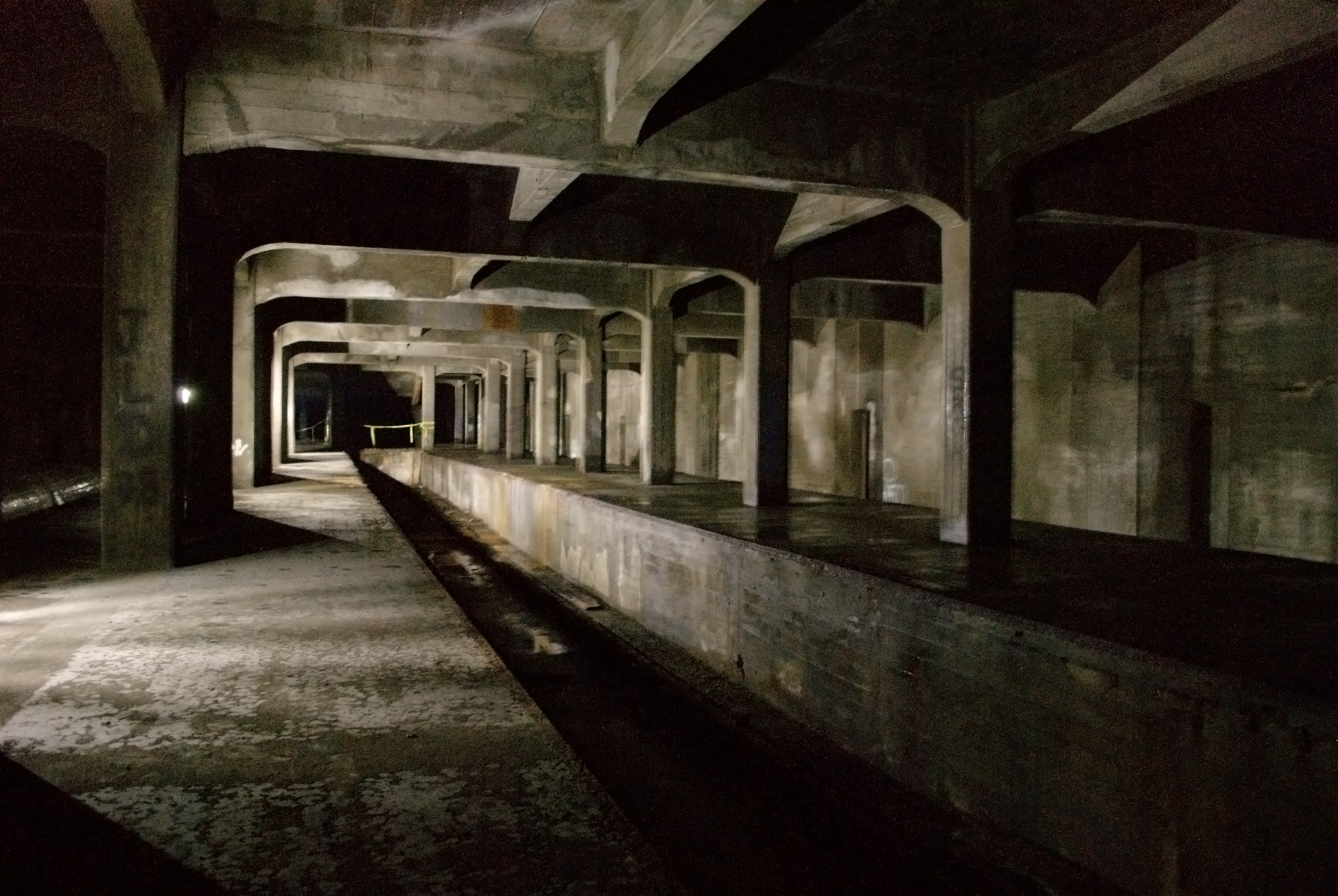
Seven stations were completed along Central Parkway: four underground and three above ground. The underground stations remain intact,[8] but the above-ground stations were demolished when I-75 was built in the 1960s. The underground stations' locations are at Race Street, Liberty Street, Linn Street, and Brighton Place, while the above-ground stations' locations were at Marshall Street, Ludlow Avenue, Clifton Avenue, and Reading Road.
The first station was the Race Street station, which was to serve as the main hub. It was configured with the platform in the center, with the subway running along the north and south side. Next was Liberty Street, which was a through-station. It was a simple design with a platform on each side of the track. Third was Linn Street, also a through station. Laid out similarly to Liberty Street, this station has been sealed up, and can be easily missed when walking through. Fourth was Brighton Place, another through-station.
Marshall Street was the most grand of the above-ground stations, located to the west near the Mill Creek Valley. Ludlow Avenue Station was constructed under the south side of the Ludlow Viaduct and was also a through-station. The last to be completed was Clifton Avenue, which was located where the street passes under present day I-75. There were additional stations in the plan; however, funding ran out as the project reached Norwood.[33]
The subway tunnels run north and south. Each of the two halves of the tube has a minimum width of 13 feet (4.0 m) and a height of 15 feet 6 inches (4.72 m). Each tunnel has parallel wooden stringers which are bolted to the floor, and are intended to support steel rails that were never laid. They are 59 inches (1.5 m) from center to center, which is 2.5 inches (64 mm) wider than most railway lines. All curves in the tunnel are gradual, and on those curves the outside stringer was raised higher than the inner stringer to accommodate trains traveling at speeds of more than 40 miles per hour (64 km/h).[34]
There were many details of the unfinished subway system, such as a provision for a station at Mohawk Corner, where the wall has been set back. At Walnut Street the lines begin to curve south to go into downtown, but they are stopped short by a bricked-up wall. The subway tunnel is double-tracked throughout its entire length, with a concrete wall separating the two tracks. Openings in the wall enable persons to step from one track to another. The tunnels are well ventilated and provide much light until Liberty Street is reached.[34]
The Cincinnati Subway is an unfinished rapid transit system in Cincinnati, Ohio, comprising approximately two miles of abandoned tunnels excavated in the early 1920s as part of an ambitious plan for a 16-mile loop connecting downtown to surrounding neighborhoods, but construction ceased without any passenger service ever commencing.[1][2]Planning for the system originated with a newspaper proposal in 1884 and gained formal traction in 1912 through a city transit commission, culminating in a $6 million bond issue approved by voters in 1916 to fund the project amid rapid urban growth and overburdened streetcar lines.[1] Construction broke ground on January 28, 1920, with tunnels largely completed by early 1923, yet the initiative faltered by 1927 due to rampant inflation that ballooned costs beyond initial estimates, exhaustion of funds, shifting political priorities, and the onset of the Great Depression following the 1929 stock market crash.[1][3] The rise of affordable automobiles further eroded public support for rail-based transit, redirecting infrastructure investments toward roadways, including partial integration of the tunnels into highway supports like Interstate 75.[1] By 1966, the project's total expenditure reached $13,019,982.45, including interest, with entrances sealed and tunnels blocked for safety, rendering the network silent and inaccessible for over 50 years.[1]Though never operational, the Cincinnati Subway represents one of the most substantial incomplete urban rail endeavors in the United States, with portions occasionally considered for auxiliary uses such as water mains.[4] In recent developments as of 2024–2025, city officials have sought public proposals for repurposing the tunnels, ranging from historical tours and cultural venues to potential light rail revival, though no concrete plans have advanced amid ongoing evaluations of feasibility and costs.[2][5]
Historical Context
Urban Transportation Challenges Pre-1910
Cincinnati's population surged from 296,908 in 1890 to 325,902 in 1900, positioning it among the ten largest U.S. cities and driving residential expansion into the surrounding steep hillsides amid industrial growth in meatpacking, brewing, and manufacturing.[6] This outward migration overwhelmed the city's nascent public transit infrastructure, as workers commuted longer distances to central business districts concentrated in the downtown basin.[1]Horsecar lines, operational since the 1850s, had largely converted to electric streetcars by 1892, expanding to over 200 miles of track by the early 1900s, yet these surface vehicles shared congested roadways with pedestrians, wagons, and emerging automobiles, resulting in frequent delays and bottlenecks.[7]Downtown convergence points exemplified the crisis: by 1902, Fountain Square—serving as a transfer hub for dozens of lines—routinely experienced gridlock, with streetcars unable to maneuver amid high volumes of converging traffic.[7] Overcrowding plagued vehicles, often exceeding designed capacities; reports documented cars stuffed with up to 117 passengers, leading to discomfort and inefficiency during peak hours.[8] Safety deteriorated accordingly, with streetcars implicated in 22 fatalities in 1906 and 13 more in the first quarter of 1907, underscoring operational hazards from overloaded systems navigating tight urban grids.[9]The city's topography compounded these issues, as the basin's seven encircling hills restricted efficient rail routing; inclines, such as the Mt. Adams Incline operational from 1872 to 1948, provided vertical access but operated at low speeds (around 500 feet per minute) and limited capacities of 20-30 passengers per car, failing to scale with demand.[7] Cable cars supplemented inclines in areas like Walnut Hills but suffered reliability problems from mechanical failures and steep grades exceeding 20%.[7] Nine interurban electric lines funneled additional riders into the city core by 1910, yet without grade-separated infrastructure, street-level bottlenecks persisted, averaging speeds below 10 miles per hour in dense districts and hindering economic connectivity.[1] These constraints highlighted the inadequacy of surface transit for a burgeoning metropolis, prompting early discussions of underground or elevated alternatives to alleviate surface pressures.[7]
Initial Rapid Transit Proposals
In the late 19th century, Cincinnati's growing population and reliance on streetcars and the Miami and Erie Canal highlighted transportation bottlenecks, prompting early suggestions for underground rail. On September 15, 1883, The Graphic, a local weekly magazine, advocated converting the disused canal bed—derisively called the "dead old ditch"—into a route for a steam-powered subway to alleviate surface congestion. Similar ideas resurfaced in 1884, with proposals to replace the canal with a combined street and subway for steam trains, though these remained conceptual without formal engineering studies or funding.[1]By the early 1900s, nine interurban rail lines converging on the city intensified demands for a coordinated rapid transit solution to integrate suburban feeders with downtown access, as streetcar overcrowding and slow speeds hampered economic efficiency.[1] In 1911–1912, the city leased the canal right-of-way, allocating $50,000 for initial surveys and estimates to explore elevated, subway, and surface options.[1]The pivotal development occurred in March 1912, when Hamilton County appointed a three-man Board of Rapid Transit Commissioners to devise a system making transit "rapid" amid escalating urban growth.[1][10] The board hired a Chicago-based planner and electric railroad consultant, Bion J. Arnold, who published the first looped rapid transit route plan for the city that year.[11] Arnold's 1912 report analyzed the city's topography, existing traction lines, and traffic patterns, proposing an integrated electric railway terminal system to handle interurban and local traffic efficiently.[12]The commission evaluated six alternative schemes, settling on a 16-mile loop encircling the urban core, combining subway, surface, and elevated segments at an initial estimated cost of $12 million—later scaled back to $6 million for voter feasibility.[1] The route originated at Fourth and Walnut streets near Fountain Square, proceeded north via subway along the former canal bed to Brighton, transitioned to surface tracks through the Mill Creek Valley to St. Bernard, extended eastward via surface through Norwood, Oakley, and Evanston, then returned downtown on an elevated structure paralleling the Ohio River.[1] This design aimed to decongest downtown streets by diverting traffic underground where feasible, leveraging the canal's straight alignment for cost-effective tunneling while using open cuts and elevations elsewhere to minimize expenses and engineering challenges.[1][11] The proposals emphasized third-rail electrification for speed and capacity, drawing on precedents like Boston's subway, but prioritized practical integration with private traction companies over full public ownership.[13]
Planning and Design
1916 Bond Campaign and Voter Approval
In early 1916, the Cincinnati Rapid Transit Commission, tasked with developing a comprehensive mass transit solution, requested city council authorization for a $6 million bond issue to fund construction of an interurban entrance and rapid transit railway system, including subway segments along the former Miami and Erie Canal bed.[1] City council approved the referendum request on March 14, 1916, placing the measure before voters in a special election.[1]The campaign emphasized a 16-mile rapid transit loop designed to integrate subway tunnels in downtown areas with elevated and surface tracks elsewhere, aiming to connect key neighborhoods, reduce streetcar overcrowding, and facilitate interurban rail links to suburbs and beyond.[14] Promotional materials, such as a voter booklet titled Inter-urban Entrance and Rapid Transit Railway for the City of Cincinnati, highlighted engineering feasibility, cost efficiency through reuse of canal infrastructure, and the system's potential to emulate successful urban rail networks in cities like New York and Boston.[15] Proponents argued that the project would address escalating traffic demands from population growth, with Cincinnati's streetcar ridership exceeding capacity amid industrial expansion.[16]On April 25, 1916, voters decisively approved the bond issue by a margin of 39,726 to 6,652, reflecting approximately an 86% favorable vote and strong public consensus on the need for modernized transit infrastructure.[1] This overwhelming endorsement, equivalent to a six-to-one ratio, validated the commission's planning efforts and allocated funds for initial surveys, land acquisition, and eventual construction commencement post-World War I delays.[16] Opposition, though minimal, centered on fiscal conservatism and concerns over potential tax burdens, but failed to sway the electorate amid broader optimism for economic benefits.[1] The approval marked a pivotal step toward realizing the subway vision, with bonds ultimately repaid by 1966.[1]
Proposed Route and Station Configurations
The proposed Cincinnati Subway constituted a 16-mile, two-track rapid transit loop designed to alleviate urban congestion by integrating subway tunnels, cut-and-cover construction, bored tunnels, surface alignments, and elevated sections.[11] The route originated in downtown Cincinnati near Fountain Square at 4th and Walnut Streets, extending northward in subway alignment along the former Miami and Erie Canal bed for approximately four miles to beyond Bates Avenue.[1] This initial segment traversed under Central Parkway through neighborhoods including Mohawk and Brighton, reaching Ludlow Avenue before transitioning to surface trackage paralleling the canal right-of-way (now largely Interstate 75) toward St. Bernard.[11]From St. Bernard, the line veered eastward to Norwood via surface and tunneled sections under Montgomery Road and Harris Avenue, then turned southward through Oakley and Evanston, incorporating additional tunnels and an elevated concrete terrace paralleling Columbia Parkway for 6,100 feet before boring through Mt. Adams to reconnect downtown.[1][11] Downtown configurations varied across planning schemes evaluated between 1912 and 1917; the 1917 bond approval, based on the 1916 campaign's Scheme Four, incorporated a 1.46-mile loop with an elevated segment on Pearl Street, alongside alternatives like Scheme II (via Plum, 5th, and Main Streets) and Scheme III (via Plum, 5th, Walnut, and 9th Streets).[11] These loops aimed to facilitate high-speed electric train operations with minimal street interference, though the core northern canal-based subway remained consistent across iterations.[17]Station configurations emphasized efficiency for rapid transit, featuring island or side platforms in underground sections for two-track lines, with high-level boarding to accommodate electric multiple-unit trains.[11] Planned underground stations included Race Street, Liberty Street (beneath the former Burger Brewing Company site), Brighton, and Hopple Street, each designed with cut-and-cover vaults for structural support and passenger access via stairs and elevators.[1][11] Surface stations further north and east, such as Crawford Street (Northside), Mitchell Avenue, Vine Street (St. Bernard), Paddock Road, Montgomery Road, and Forest Avenue (Norwood), were configured for at-grade platforms with grade-separated trackage where feasible to maintain speeds.[17] Southern extensions featured stations at Dana Avenue, Madison Road (O'Bryonville), and near the L&N Bridge, with five additional stops between Mitchell Avenue and Oakley to serve suburban growth areas.[1][17]
Segment
Key Stations
Configuration Notes
Downtown Subway (Northbound)
8th/9th Streets, Race Street, Liberty Street
Cut-and-cover tunnels; island platforms; downtown loop options via Plum/5th/Main or Walnut/Pearl.[17]
Central Parkway to Canal Surface
Brighton, Hopple Street, Ludlow Avenue, Crawford Street
Transition from subway to surface; side platforms at-grade.[11]
Dacey Avenue, Dana Avenue, Madison Road (O'Bryonville), L&N Bridge area
Tunnels under Montgomery/Harris; elevated terrace on Columbia Parkway; bored Mt. Adams tunnel.[17][1]
Construction Efforts
Timeline of Building Activities (1920-1927)
Construction of the Cincinnati Subway's underground tunnels began on January 28, 1920, with the first steam shovel breaking ground at Walnut Street, following the award of initial contracts in late 1919 and early 1920: Section 1 for $500,000 on November 17, 1919; Section 2 for $500,000 on February 12, 1920; and Section 3 for $550,000 in September 1920.[1] These contracts targeted the core two-mile twin-bore subway alignment under Central Parkway, utilizing cut-and-cover methods along the former Miami and Erie Canal right-of-way.[18]In 1921, postwar inflation eroded the $6 million bond authorization's purchasing power, limiting feasible construction to about 11 of the planned 16 miles, while Section 4 was awarded for $500,000 on June 2; blasting in the Brighton neighborhood faced over two months of delays due to resident complaints about property damage vibrations.[1] Section 5 followed in December 1921 for $150,000, but protracted negotiations with the cities of St. Bernard and Norwood stalled progress for more than a year, complicating suburban extensions.[1]By early 1923, the primary two-mile subway tunnels were completed under four main contracts spanning 1920 to 1923, though no tracks, signals, or stations were yet installed.[18][1] Section 6 was awarded in June 1922 for $325,000, advancing the loop's subsurface segments.[1]In 1924, Sections 7 through 9 were contracted on June 6 for a combined $1.1 million, with the first six sections finalized by October; however, further delays arose from Norwood's ordinance passage and St. Bernard's agreement, not resolved until June 1925.[1] A fifth subway contract, funded separately via Central Parkway bonds, extended tunneling efforts.[18]Aboveground loop sections approached completion by early 1927, including additional tunnels such as the Hopple Street Tunnel constructed as late as 1926–1927, but the $6 million budget was exhausted without provisioning for rails, power systems, or rolling stock, halting substantive progress.[1] Overall, these activities yielded approximately 2.2 miles of unfinished twin tunnels by 1927, amid rising costs that exceeded initial estimates due to inflation and legal hurdles.[3]
Engineering Achievements and Innovations
The Cincinnati Subway project demonstrated advanced tunneling capabilities for its era by combining cut-and-cover excavation with bored tunneling to address Cincinnati's hilly terrain and urban constraints. Cut-and-cover methods were applied to the 6.5-mile subway segment along the drained Miami and Erie Canal bed beneath Central Parkway, enabling rapid progress in a pre-excavated trench using steam shovels for earth removal and subsequent concrete lining of twin tunnels measuring 13 feet wide by 16 feet high.[11][19] This approach, initiated in January 1920, yielded approximately two miles of completed tunnel by early 1923, with structural elements designed for durability that have withstood over a century of disuse and incidental loading from overlying infrastructure.[19]A key innovation lay in the 0.63-mile bored tunnel through Mt. Adams, a steep limestone-capped hill rising over 300 feet above the Ohio River, executed via sequential mining and timber-supported advances before permanent arching, which minimized surface disruption in a densely built area.[11] This deep-level boring, supplemented by a shorter 500-foot tunnel under Hopple Street, allowed the system to achieve grades up to 4 percent—steeper than typical streetcar lines—facilitated by electric traction motors that provided superior power-to-weight ratios compared to steam or cable systems prevalent in earlier urban rail projects.[11] Such integration of electrification with tunneling optimized route efficiency, reducing the need for extensive elevated structures and exemplifying causal adaptation to local geology where clay and shale layers provided stable overburden support.[19]The tunnels' engineering resilience is evidenced by their intact condition as of the 1990s, housing utility lines without major reinforcement, a testament to conservative design factors including thick concrete linings and groundwater management via the canal's prior drainage.[19] Construction phases from 1920 to 1927 prioritized phased bidding across nine sections, achieving seven miles of surface trackage alongside the subsurface work despite material cost inflation from 40 cents to over 80 cents per cubic yard for concrete, highlighting resource-efficient scaling under fiscal pressures.[11] These features collectively advanced urban rapid transit engineering by prioritizing subsurface solutions over costlier full-elevated alternatives, though ultimately limited by funding shortfalls rather than technical shortcomings.[19]
Suspension and Abandonment
Immediate Triggers in 1929
In early 1929, Mayor Murray Seasongood, leading the reform-oriented Charter Party administration elected to dismantle entrenched political corruption, discontinued the Rapid Transit Commission, which had overseen the project since its inception, thereby assuming direct city control and halting ongoing activities.[20] Seasongood had advocated pausing construction until the commission's term expired on January 1, 1929, amid concerns over escalating costs that had already exhausted the original $6 million voter-approved bond from 1916, with post-World War I inflation driving material and labor expenses far beyond initial estimates.[3][20]The stock market crash on October 29, 1929, triggered the Great Depression, severely contracting municipal budgets and eliminating prospects for additional bond financing needed to complete the remaining 14 miles of the planned 16-mile system.[3][16] By December 9, 1929, the Cincinnati City Council formally voted to abandon the project, citing financial infeasibility after only 2.2 miles of twin tunnels had been excavated beneath Central Parkway, with no viable path to cover the projected additional $10-12 million required.[3][16] This decision reflected not only immediate fiscal collapse but also Seasongood's prioritization of fiscal austerity and infrastructure alternatives like the surface-level Central Parkway boulevard, which had opened earlier that year.[3][20]
Economic and Political Analyses of Failure
The Cincinnati Subway project's abandonment in 1929 stemmed primarily from a confluence of escalating construction costs and funding shortfalls, which exposed underlying fiscal mismanagement in initial planning. Approved via a $6 million bond in 1916, the project faced immediate cost overruns due to World War I-era inflation, which doubled material and labor expenses; by 1921, available funds could support only 11 of the planned 16 miles.[1] By 1927, the bond proceeds were exhausted after completing just 2.2 miles of tunnels and related infrastructure, necessitating an additional $9–10 million that voters and officials declined to authorize amid doubts over total viability.[1] The onset of the Great Depression in 1929 amplified these pressures, diverting public resources toward immediate job relief rather than long-term infrastructure, rendering further bonds politically untenable and effectively halting work.[1][19]Politically, the project became entangled with Cincinnati's machine-style governance under Republican boss George B. Cox, whose influence fostered perceptions of cronyism and inefficiency, alienating reformers. Construction delays, including a 1918 OhioSupreme Court ruling invalidating a key 1917 ordinance for procedural flaws, eroded momentum and invited scrutiny of the Rapid Transit Commission's oversight.[1] Opposition from affluent downtown property owners, who feared devaluation of holdings near Fountain Square if the system shifted activity to Central Parkway, further fragmented support, as did resistance from steam railroad interests viewing the subway's interurban terminal as competitive threat.[21] The 1925 rise of the Charter Party under Mayor Murray Seasongood marked a pivotal anti-machine shift; Seasongood dissolved the commission in 1928, demanding exhaustive studies that stalled progress until its January 1929 expiration, after which no successor funding mechanism emerged.[1][3]Analyses attribute failure less to inherent design flaws than to a mismatch between ambitious scope and fiscal realism, compounded by demographic shifts toward suburbanization and automobile adoption, which diminished projected ridership and justified sunk costs as obsolete by the late 1920s.[19] While the Depression provided the immediate catalyst, pre-1929 political realignments against entrenched interests prevented adaptive financing, as reformers prioritized governance overhaul over completion.[22] The total debt of $13 million (with interest) was repaid by 1966 without yielding operational benefits, underscoring opportunity costs in a city transitioning from rail-centric to vehicular mobility.[1]
Post-Abandonment Developments
Early Utilization of Infrastructure
Following abandonment in 1929, the Cincinnati Subway's tunnels saw limited practical repurposing in the immediate aftermath, with entrances sealed by concrete and access restricted to prevent unauthorized entry. During the 1930s, city officials explored adapting the infrastructure for streetcar operations, but these efforts failed due to the tunnels' insufficient clearance for existing trolley cars, which exceeded the designed height. Storage functions emerged sporadically, as the underground spaces provided secure, climate-controlled areas amid economic constraints of the Great Depression.[23]World War II marked the first substantive utilization, with the tunnels designated for civil defense purposes. In 1941, preliminary studies assessed their potential as air-raid shelters, leveraging the 2.2 miles of twin-bore tunnels and unfinished stations for protection against aerial attacks. Concurrently, sections were employed for underground storage of war materials, capitalizing on the infrastructure's depth—up to 75 feet below street level—and structural integrity to safeguard supplies from bombing risks. These uses, though temporary, demonstrated the tunnels' viability for emergency logistics without major modifications.[24][25]Into the early 1950s, utility integration began modestly, with portions allocated for conduit housing to route power and communication lines, reducing surface disruptions in the growing downtown area. Civil defense planning intensified, including proposals to outfit stations like Liberty Street as modern fallout shelters amid Cold War tensions, though full-scale conversions awaited federal funding later in the decade. These early adaptations underscored the infrastructure's shift from transit ambitions to auxiliary civic roles, preserving its assets amid fiscal inactivity.[23][25]
Mid-Century Revival Proposals
In the immediate postwar period, efforts to revive the Cincinnati Subway focused on assessing its viability amid shifting urban transportation priorities dominated by automobile expansion. In 1940, prior to U.S. entry into World War II, city officials consulted transportation experts to determine the system's fate, but wartime resource demands halted further action, leaving the tunnels unused for transit.[26] The prewar 1936 report by the Cincinnati Engineers Club had already deemed the infrastructure mismatched for contemporary demands, suggesting trolley integration that was never implemented due to incompatible vehicle dimensions and declining streetcar ridership.[1]By the 1950s, Cold War anxieties prompted consideration of the tunnels for civil defense rather than passenger service; they were designated as potential bomb shelters, with ventilation and other equipment installed at the Brighton Street station to support emergency occupancy.[27] This repurposing reflected pragmatic adaptation to geopolitical threats over economic revival, as federal funding increasingly favored highways under the Interstate Highway Act of 1956, sidelining urban rail projects. No feasibility studies or bond campaigns advanced tunnel completion for rapid transit during this era, underscoring causal factors like suburban sprawl and fiscal conservatism that eroded support for legacy infrastructure.Into the early 1960s, sporadic advocacy emerged for broader rapid transit but decoupled from the existing tunnels, which engineering assessments viewed as structurally sound yet logistically obsolete without major retrofits for modern electrification and signaling. Regional planners, anticipating federal aid via the Urban Mass Transportation Act of 1964, prioritized greenfield light rail concepts over rehabilitating the 1920s-era cuts, which required extensive upgrades estimated in later decades at prohibitive costs relative to new builds.[28] These mid-century discussions highlighted opportunity costs: while the tunnels represented sunk capital of approximately $7 million in 1920s expenditures, integrating them risked delays from unproven adaptations, favoring instead surface or elevated alternatives that aligned with postwar demographic shifts toward decentralization.
Modern Revival and Repurposing Debates
Late 20th to Early 21st Century Attempts
In 1971, the Ohio-Kentucky-Indiana Regional Council of Governments (OKI) developed a preliminary 57-mile regional rapid transit plan incorporating at least 10 miles of subway elements, anticipating federal funding under the Urban Mass Transportation Administration, but the proposal faced rejection amid concerns over costs and local priorities.[29] In 1974, a local civic group proposed leasing a portion of the tunnels to develop an underground entertainment district modeled on Atlanta's Underground, featuring retail shops and a nightclub, though the idea did not advance due to logistical and financial hurdles.[1] By 1977, OKI's Massive Transit Committee advocated for a light rail system akin to Chicago's, explicitly aiming to repurpose the existing tunnels for heavy-rail-style operations in response to post-OPEC embargo energy concerns, but the plan stalled without secured funding or political consensus.[1][28]The 1980s saw no major proposals for the tunnels, as regional transit discussions shifted toward bus improvements and highway expansions.[30] In the 1990s, OKI revived rail planning with a 1993 feasibility study for a 19-mile light rail line along the I-71 corridor, followed by detailed engineering around 1998 focusing on that route, including test borings for a new one-mile Mt. Auburn Tunnel; while the existing subway tunnels were occasionally referenced in broader discussions, they were not central to these corridor-specific designs, which emphasized surface and elevated alignments to minimize costs.[30][29][31]The most ambitious early 21st-century effort came in 2002 with the MetroMoves initiative, proposed by the Southwest Ohio Regional Transit Authority (SORTA), which outlined a $2.6 billion, 30-year regional system including bus rapid transit, commuter rail, and light rail lines; the plan specifically incorporated the abandoned subway tunnels into the proposed West Side Line for underground segments connecting downtown to western suburbs, projecting integration with new extensions.[32][31] Funded via a proposed 0.5% sales tax increase, MetroMoves promised enhanced connectivity but was defeated in a November 5 referendum by a 53% to 47% margin, attributed to voter skepticism over high capital costs, projected low ridership in an auto-centric region, and competing infrastructure priorities like roads.[33] These repeated failures underscored persistent challenges in aligning public support with the engineering and fiscal demands of tunnel reactivation, including structural retrofits for modern standards and ventilation upgrades estimated in later analyses at over $100 million for basic usability.[34]
2024-2025 Feasibility Studies for Alternative Uses
In October 2024, the City of Cincinnati issued a request for information (RFI) soliciting conceptual proposals from firms, architects, and designers to identify potential commercial or other uses for portions of the abandoned subway tunnels, particularly the 2.2-mile segment beneath Central Parkway.[35][2] The initiative focused on adaptive reuse of the infrastructure, which currently accommodates a water main and communications cables, while evaluating structural viability for non-transit purposes such as tourism or recreational amenities.[36]Responses to the RFI, unveiled in January 2025, included diverse concepts like underground theaters, bathhouses, speakeasies, kayak training facilities, and experiential attractions aimed at leveraging the tunnels' historical novelty for economic development.[37][38] These ideas emphasized low-impact rehabilitation to avoid major disruptions to existing utilities, though none prioritized full-scale rail revival, reflecting pragmatic constraints from prior engineering assessments indicating high costs for transit restoration.[39]Advancing from these preliminaries, on September 22, 2025, the city released a Request for Proposals (RFP) for a comprehensive feasibility study to further evaluate repurposing options, including infrastructure assessments, cost projections, and regulatory hurdles for adaptive uses.[40][41] The RFP explicitly lists public transit among potential avenues but prioritizes "unique amenities" convertible to revenue-generating features, with submissions due by October 21, 2025.[42][43] Local reporting attributes the push to longstanding interest in monetizing underutilized assets without committing to capital-intensive rail projects, amid skepticism from transit proponents who view commercial pivots as diminishing opportunities for mobility enhancements.[44]
Engineering Details
Tunnel and Station Specifications
The Cincinnati Subway tunnels comprise approximately 2.1 miles of parallel reinforced concrete tubes constructed beneath Central Parkway, extending from Walnut Street to a point north of the Western Hills Viaduct.[45] These tunnels were built entirely of reinforced concrete in four phases between 1920 and 1923, utilizing the drained bed of the Miami and Erie Canal for stability.[45][1] Each tube features dimensions of about 15 feet in height and 13 feet in width, with a minimum curve radius of 1,000 feet to support speeds up to 45 mph, except for a sharp 90-degree turn at Plum Street.[45] A shorter 400-foot tunnel segment exists under Hopple Street, featuring similar portals to the main line.[45]Four unfinished stations were incorporated into the tunnel system: Race Street, Liberty Street, Linn Street (also known as Mohawk's Corner), and Brighton's Corner.[45] Station platforms measure approximately 300 feet in length, with the Race Street station featuring an extended 600-foot island platform accommodating three tracks and center stubs for interurban services; platforms stand 48 inches high throughout.[45] Depths vary, with Brighton's Corner at 15 feet and Liberty Street at 20 feet below street level.[45] These stations lack mezzanines and accessibility features, rendering them unsuitable for modern standards without significant modification.[45][19] The design originally accommodated steam locomotives, with wooden rail runners and superelevated curves, alongside drainage systems to prevent water accumulation.[45] Concrete pillars support platforms, spaced 4 feet from edges at Brighton's Corner and in two rows at Liberty Street.[45]
Structural Condition and Utility Integration
The Cincinnati Subway tunnels, built between 1920 and 1927 using reinforced concrete arches typically 13 feet wide and 16 feet high, exhibit a stable yet aging structural condition after nearly 100 years of abandonment. City engineers assess the overall system as in "fair" shape, with annual inspections revealing deterioration in concrete integrity, ventilation systems, and water infiltration in certain sections.[46][47] Maintenance efforts, including repairs conducted in the 1980s, have preserved core stability without major collapses, though substantial reinforcements would be required for adaptive reuse.[19]Utility integration has repurposed segments of the 2.2-mile tunnel network for essential infrastructure since the mid-20th century. A 48-inch diameter pressurized water main, installed in 1957, traverses much of the Central Parkway alignment, delivering supply from the Ohio River to downtown and westward areas under the management of Greater Cincinnati Water Works.[40][19] Additionally, the tunnels accommodate communication cables and fiber-optic lines, enhancing urban connectivity while necessitating careful coordination to avoid conflicts in any future modifications. This dual use underscores the tunnels' enduring engineering value, though the embedded utilities pose logistical challenges for transit-oriented revival proposals.[40]
Controversies and Criticisms
Fiscal Waste and Cost Overruns
The Cincinnati Subway project, approved via a $6 million bond issue by voters on November 7, 1916, initially promised a 16-mile rapid transit loop at a reduced estimated cost of $6 million after planners scaled back from an original $12 million projection.[23][1] Construction began in March 1920, but by the mid-1920s, escalating expenses from post-World War I inflation, rising labor and material costs, and on-site construction errors had depleted funds, halting work in 1924 after only about 2 miles of tunnel and partial station excavations were completed.[48][49][46]A 1929engineering board report attributed the shortfalls primarily to inflation but estimated an additional $9–10 million would be required to complete even a truncated 11-mile version, excluding the uneconomical eastern loop segment.[1] Mid-1920s proposals for $3.5 million supplemental levies to resume work were rejected by voters amid growing skepticism over further expenditures and the project's viability.[27] Contributing factors included documented construction mishaps, such as unstable tunneling through challenging geology leading to property damage claims, and political maneuvering that delayed resolutions and inflated administrative overhead.[50] These overruns transformed the initial investment into a sunk cost, with approximately $5.9 million expended on incomplete infrastructure by abandonment in December 1929, yielding no operational transit benefit.[1]The fiscal burden extended beyond construction, as the $6 million bonds—serviced through property taxes—were not fully repaid until 1966, accruing $7,019,982.45 in interest for a total taxpayer outlay of $13,019,982.45 on a defunct project.[1][3] This prolonged debt repayment, unmitigated by any revenue-generating use of the assets, exemplifies inefficient capital allocation, where early optimism overlooked risks from volatile 1920s economics and inadequate contingency planning, ultimately leaving Cincinnati with derelict tunnels rather than functional infrastructure.[51] Post-abandonment maintenance has added further costs, including over $6.7 million in major repairs since the 1990s to prevent structural failures and flooding, underscoring ongoing fiscal drag from the original mismanagement.[46]
Opportunity Costs Versus Transit Advocacy Claims
The Cincinnati Subway project's abandonment in 1929 imposed significant opportunity costs on the city, as the approximately $13 million expended—including principal, taxes, and interest on bonds issued starting in 1916—yielded no operational transit infrastructure despite tunneling nearly three miles of the planned 16-mile system.[52] This expenditure, equivalent to roughly $200 million in 2025 dollars adjusted for inflation, diverted funds from alternative investments such as roadway expansions or bus fleet modernizations, which became viable amid the rise of affordable automobiles and the shift away from streetcars during the Great Depression.[1] The project's partial completion exacerbated Cincinnati's fiscal strain, contributing to municipal bankruptcy proceedings in the 1930s, as ongoing debt service persisted without revenue generation from the tunnels.[48]Maintenance of the unused tunnels has compounded these costs, with the city incurring over $6.7 million in major repairs from 1991 to 2021 (inflation-adjusted) and an estimated $2.6 million for basic preservation over five years as of 2021 assessments.[46] Economists critiquing sunk-cost fallacies in infrastructure projects argue that these expenditures represent irrecoverable losses, as the funds could have supported scalable surface transit options better suited to Cincinnati's hilly topography and suburban growth patterns, where bus rapid transit lines have achieved higher utilization rates than fixed-rail systems in comparable mid-sized U.S. cities.[53] For instance, post-abandonment investments in the Cincinnati Street Railway's bus conversions in the 1930s provided flexible service at lower capital outlays, averting the ridership shortfalls seen in underutilized subways elsewhere.[11]Transit advocates, including groups like All Aboard Ohio, contend that repurposing the tunnels for modern light rail or a commuter loop could deliver long-term benefits such as reduced congestion and economic revitalization, potentially integrating with regional lines to Hamilton.[42] They cite projected connectivity gains and environmental advantages, arguing that the existing infrastructure offsets new construction expenses and that completion might have historically prevented urban sprawl by anchoring density downtown.[54] However, feasibility studies contradict these claims, estimating retrofit costs at $100.5 million in 2007 for basic usability or up to $560 million in 2025 for full transit integration, with public subsidies covering 70% amid uncertain ridership in a city where current Metro bus occupancy averages below 20 passengers per vehicle-hour.[55][40] Independent analyses highlight that such fixed-guideway proposals often yield negative returns in low-density metros like Cincinnati, where flexible bus or BRT alternatives have demonstrated cost-effectiveness ratios under $10 million per mile versus $100 million-plus for rail, underscoring the persistent opportunity costs of pursuing advocacy-driven revival over empirically validated surface options.[28][56]
Legacy and Broader Impacts
Influence on Cincinnati's Urban Development
The acquisition of rights-of-way for the Cincinnati Subway in the 1910s reserved linear corridors through densely populated areas, influencing land use patterns by prioritizing subsurface infrastructure over immediate surface development. Approved via a $6 million bond issue on April 25, 1916, these parcels spanned a planned 16-mile loop, with construction commencing January 28, 1920, and yielding approximately two miles of tunnels by 1923 at a cost exceeding $13 million including interest.[1] This front-loaded investment deferred alternative urban expansions along the routes, such as intensified commercial zoning or housing, as the city awaited transit completion.Following abandonment in 1927 amid funding shortfalls and inflation—exacerbated by the Great Depression—these rights-of-way were repurposed for automotive infrastructure, marking a pivotal shift in Cincinnati's growth trajectory. Central Parkway, a major surface boulevard, opened in October 1928 directly atop portions of the subway alignment, converting potential transit hubs into divided roadways that facilitated vehicular traffic and commercial strip development.[1] Subsequently, the corridors supported interstate highways, including Interstate 75 and the Norwood Lateral, enabling radial suburban expansion from downtown core to outlying areas like Norwood and Oakley, with land uses evolving toward auto-oriented retail, industrial parks, and low-density housing clusters accessible via high-capacity roads rather than pedestrian-scaled transit nodes.[1]The subway's incomplete status entrenched a legacy of fiscal and infrastructural path dependency, as the city repaid bonds until 1966 while maintaining sealed tunnels as civil defense shelters in the 1960s, diverting resources from other planning initiatives.[1] Absent the rapid transit backbone, Cincinnati's urban form prioritized highway adjacency for economic activity, contributing to patterns of decentralization observed in peer cities during the interwar and postwar eras, where rail-era density gave way to sprawl supported by federal interstate funding. This outcome underscored the causal role of sunk costs in steering development away from compact, rail-served neighborhoods toward expansive, car-reliant peripheries.
Lessons in Government-Led Infrastructure Projects
The Cincinnati Subway exemplifies risks inherent in government-led infrastructure initiatives, where initial public enthusiasm can mask deficiencies in planning and execution. Approved by voters in 1916 with a $6 million bond issuance, the project aimed to construct a 16-mile rapid transit loop but was abandoned in 1929 after expending funds on only 2.2 miles of tunnels, ultimately costing $13 million including interest paid off by 1966.[1] Construction delays from World War I material shortages, property damage lawsuits, and inflation that doubled costs underscored failures in accurate forecasting and contingency planning, common in publicly funded ventures lacking market-driven incentives to control expenditures.[48][53]A primary lesson is the peril of underestimating technological and economic shifts; projections assumed sustained demand for rail amid streetcar reliance, but the 1920s rise of automobiles eroded ridership viability, rendering the system obsolete before completion.[57][48]Government planners, insulated from profit-loss discipline, failed to adapt, prioritizing fixed infrastructure over flexible responses to consumer preferences that favored personal vehicles—93% of Cincinnati workers commuted by car by 2019.[57] Political factors exacerbated issues, with cronyism under figures like George "Boss" Cox and subsequent reformist dissolution of the oversight commission halting progress amid funding shortfalls and the Great Depression.[48]Further, the episode highlights bureaucratic inertia and the sunk cost dilemma in public projects, where $9-10 million more was needed to salvage the incomplete system, yet abandonment prevented deeper waste—though the tunnels remain unused, symbolizing fiscal misallocation.[1][53] This bred lasting voter skepticism, evident in the 2002 rejection of the $2.6 billion MetroMoves expansion by a 2:1 margin, reflecting eroded trust in government estimates of costs and benefits.[53] Effective alternatives demand rigorous feasibility studies, private sector involvement for cost discipline, and mechanisms to pivot based on real-time data rather than rigid political commitments, as central planning often amplifies errors without corrective feedback loops.[57][53]


 Geographic data related to Cincinnati Subway at OpenStreetMap