Hubbry Logo
Cockpit CountryCockpit CountryMain
Open search
Cockpit Country
Community hub
Cockpit Country
logo
8 pages, 0 posts
0 subscribers
Be the first to start a discussion here.
Cockpit Country
Cockpit Country
from Wikipedia

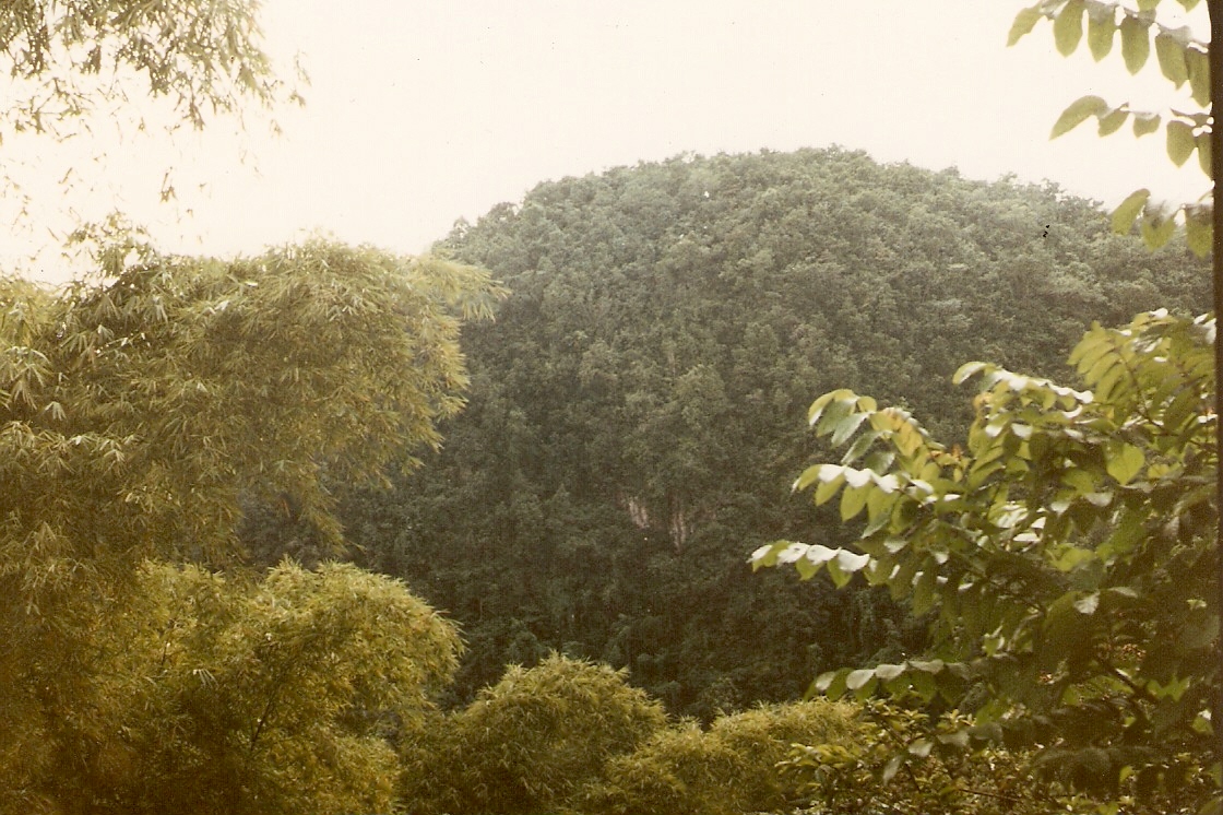
Cockpit Country is an area in Trelawny and Saint Elizabeth, Saint James, Saint Ann, Manchester and the northern tip of Clarendon parishes, mostly within the west-central side, of Jamaica. The land is marked by lush, montane forests and steep-sided valleys and hollows, as deep as 120 metres (390 ft) in places, separated by conical hills and ridges.

Key Information

During the 16th and 17th centuries, maroons—the escapee former slaves (and their descendants) of the island's Spanish and British-operated sugarcane plantations—used this rugged terrain to their benefit, carving out an existence on their own, away from the violent slavers and colonial powers of the lowlands.[1]

History

[edit]

In the late seventeenth century, the Cockpit Country was a place of refuge for Jamaican Maroons fleeing slavery. During the course of the First Maroon War, there were two Leeward Maroon communities - Cudjoe's Town (Trelawny Town) and Accompong Town. Cudjoe's Town was located in the mountains in the southern extremities of Saint James Parish, Jamaica, close to the border of Westmoreland Parish. Accompong is situated just to the south of Cudjoe's Town, on the border between Westmoreland and Saint Elizabeth Parish.[2]

When the Leeward Maroons signed a peace treaty in 1740, they assisted the colonial authorities in pursuing runaway slaves who sought refuge in the Cockpit Country. However, these runaways allied with Trelawny Town during the Second Maroon War. When the Maroons of Trelawny Town were deported in 1796, the Maroons of Accompong had difficulty policing the Cockpit Country, and several communities of runaway slaves established themselves there. After the removal of the Trelawny Maroons, the colonial militia built a barracks at their village, which they renamed Maroon Town, Jamaica.[3]

At the start of the nineteenth century, Cuffee established a community of runaway slaves in the Cockpit Country, and resisted attempts by the colonial authorities and the Maroons of Accompong Town to rout them. Then, in the second and third decades of the century, another group of runaway slaves from Trelawny Parish set up a community in the Cockpit Country at Me-no-Sen-You-no-Come. They also succeeded in resisting attempts by the colonial militias and Accompong Town to rout them. During the Baptist War of 1831–2, more slaves ran away and found freedom in the Cockpit Country.[4]

Geography

[edit]

On the north, the main defining feature is the fault-based "Escarpment", a long ridge that extends from Flagstaff in the west, through Windsor in the centre, to Campbells and the start of the Barbecue Bottom Road (B10). The Barbecue Bottom Road, which runs north–south, high along the side of a deep, fault-based valley in the east, is the only drivable route across the Cockpit Country. Walkers and riders can use two old, historical trails cross further west, the Troy Trail, and the Quick Step Trail. As of 2006 they are seldom used and difficult to find.

Map of Cockpit Country

In the southwest, near Quick Step, is the district known as the "Land of Look Behind." It was so named because Spanish horsemen venturing into this region of hostile escaped slaves were said to have ridden two to a mount, one rider facing to the rear to keep a precautionary watch against ambush.

Where the ridges between sinkholes in the plateau area have dissolved, flat-bottomed basins or valleys have been formed that are filled with terra rosa soils, some of the most productive on the island. The largest basin is the Vale of Clarendon, 80 kilometres (50 mi) long and 32 kilometres (20 mi) wide. Queen of Spains Valley, Nassau Valley, and Cave Valley were formed by the same process.

Shallow caves, known locally as cockpits, are particularly common around the hamlet of Quick Step, reaching a density of 15 per km2.[5] Noteworthy caves include Marta Tick Cave[6] and Minocal's Glory Hole.[7] Ecotourism has been proposed for the hamlet of Quick Step, at the end of the road into the heart of Cockpit County.[8]

Environment

[edit]
Bauxite is mined in Cockpit Country

The Cockpit Country is Jamaica's largest remaining contiguous rainforest. Cockpit Country Forest Reserve was designated in 1950, and covers an area of 221.75 km2.[9] In 1979 an unpublished paper proposed preserving the area as a National Park.[10] In 1994 the geographer Alan Eyre[11] proposed that the Cockpit Country be designated as a World Heritage Site to preserve its environment. A petition for protection of the area was submitted to Prime Minister Bruce Golding in 2006. In April 2013, public consultations began on the definition of the boundary proposed in a recently released study by Mitchell, Miller, Ganapathy, and Spence of the University of the West Indies (UWI).

Wildlife

[edit]

Eleutherodactylus sisyphodemus, a small, critically endangered frog species, is known only from the Cockpit Country.[12][13] Cockpit Country hosts 90% of the global population of black-billed amazon, a parrot endemic to Jamaica.[14] Cockpit Country is also home to the Jamaican swallowtail, the largest butterfly in the Western Hemisphere. Cockpit Country is one of the last remaining homes for the species. The area has been designated an Important Bird Area (IBA) by BirdLife International because it supports significant populations of many Jamaican bird species.[15]

See also

[edit]

References

[edit]
[edit]
Revisions and contributorsEdit on WikipediaRead on Wikipedia
from Grokipedia
Cockpit Country is a rugged region in northwestern , defined by its cockpit of thousands of steep-sided, circular depressions and residual conical hills formed through chemical dissolution and erosion of the White Limestone Group since uplift in the . This landscape spans approximately 1,300 km² across primarily Trelawny, St. James, and St. Elizabeth parishes, making it Jamaica's largest contiguous and a critical area for with numerous endemic species adapted to its isolated microhabitats. The region's impenetrable terrain historically served as a stronghold for —escaped enslaved Africans—who utilized its natural defenses for against British colonial forces during the , culminating in a 1739 signed by Leeward Maroon leader that granted semi-autonomous control over portions of Cockpit Country in exchange for peace and assistance against further rebellions. This accord preserved cultural practices and land rights, influencing Jamaica's social and political history. Designated as a forest reserve in 1950, Cockpit Country exemplifies tropical as the type locality for cockpit karst and supports montane forests vital for water catchment and , though it faces ongoing pressures from proposed that threaten its integrity despite declarations of protection. Its defining characteristics—geological uniqueness, historical resistance, and ecological richness—underscore its status as a globally significant and cultural feature.

Geography

Geological Formation and Topography

Cockpit Country exhibits a classic example of cockpit karst topography, characterized by an irregular array of steep-sided, conical hills interspersed with deep, star-shaped depressions or "cockpits" that can reach depths of up to 150 meters. These landforms result from the intense chemical dissolution of soluble bedrock combined with physical in a humid , producing a landscape of residual hills and enclosed valleys without significant surface drainage. The region's surface is predominantly rugged and impenetrable, with elevations ranging from to approximately 700 meters, and an average hill density that creates a highly dissected covering roughly 750 square kilometers in north-central . Geologically, the area is underlain chiefly by the White Limestone Group, a Miocene-age (approximately 23 to 5 million years old) sequence of dense, well-jointed s deposited in shallow marine environments. Formation began around 12 million years ago when tectonic uplift along fault lines elevated a limestone plateau above the , exposing it to weathering. Subsequent karstification intensified due to high rainfall—averaging over 2,000 mm annually—which facilitates dissolution along joints and bedding planes, preferentially enlarging fissures into sinkholes and dolines while leaving rounded hilltops as uneroded residuals. Minor contributions from the underlying Moneague and Chapelton Formations, comprising impure limestones and marls, influence localized variations but constitute less than 10% of the subsurface. The interplay of and climatic factors has produced a polygonal pattern unique to tropical settings, where vertical jointing in the promotes uniform and the development of tower-like hills up to 200 meters high. Unlike smoother cone elsewhere, the cockpit variety features sharper, more angular depressions due to the bedrock's high purity and fracturing, with minimal alluvial fill in valleys owing to rapid subsurface drainage. This evolution, ongoing since the , underscores the region's status as the type locality for cockpit , as recognized in geomorphological studies.

Hydrology and Caves

Cockpit Country's hydrology is dominated by its , where rainfall and surface streams quickly infiltrate through numerous sinkholes, fissures, and dolines, forming an extensive subterranean drainage network rather than prominent above-ground rivers. This system exhibits rapid recharge and discharge, with circulation intensifying during wet seasons, leading to seasonal variations in flow and levels that can approach the base of epikarst features. Springs emerge primarily along the northern and western margins at elevations around 170 meters above , often 10 to 30 kilometers from inland sink points, supplying freshwater that accounts for approximately 40% of the requirements for six western Jamaican parishes. The aquifer's complexity arises from the interplay of autogenic recharge—where precipitation percolates directly through the — and allogenic inputs from sinking rivers, resulting in unpredictable flow paths that challenge conventional hydrogeological modeling. Underground streams carve passages, lowering the over time and promoting cave collapse into sinkholes, which further accentuate the topography. Potential risks are heightened due to minimal filtration in the fissured , as evidenced by concerns over activities that could pollute downstream sources. Caves form integral components of this hydrological system, with over 1,200 registered entrances, passages, and sinkholes contributing to the region's subterranean volume. Windsor Great Cave, extending approximately 3 kilometers, exemplifies active processes, with sections still experiencing floodwater flows during heavy rains that continue to sculpt its chambers. Other notable systems include Bad Hole , which demonstrates rapid hydrological connectivity via sinking streams, and Printed Circuit , featuring intricate formations shaped by prolonged subsurface erosion. Larger chambers, such as one documented at 200 feet high and wide by 300 feet long, highlight the scale of dissolution processes, while features like stalactites and stalagmites in Rock Spring Cave illustrate ongoing deposition from mineral-rich drip waters. These caves often interconnect with the broader , facilitating movement but also posing exploration challenges due to flooding risks and structural instability from prior collapses.

History

Indigenous and Early Colonial Period

The , an Arawak-speaking indigenous people, migrated to between approximately AD 600 and 900, establishing settlements across the island, including in regions encompassing modern Cockpit Country such as , where over 23 Taíno sites have been identified. These communities, organized under caciques (chiefs), practiced communal living, agriculture with crops like and , fishing, and crafting in wood, pottery, and stone; while primarily coastal, archaeological evidence including cave art and petroglyphs in Cockpit Country's features indicates inland utilization and possible refuge use amid the terrain's natural fortifications. Christopher Columbus first landed in Jamaica in 1494 during his second voyage, initiating Spanish contact; by 1509, the island was formally colonized as Santiago under Spanish rule, which persisted until 1655. The Spanish exploited labor for , pearl diving, and systems, leading to rapid population collapse from introduced diseases like , overwork, and violence; estimates place the pre-contact population at 60,000 across , reduced to near extinction within decades. Some survivors fled into Cockpit Country's inaccessible sinkholes and ridges, following pre-existing trails that Spanish explorers later used for penetration, though the area's ruggedness limited sustained colonial settlement or exploitation during this era. Spanish administration focused on coastal and eastern plains for ranching and limited , importing African slaves by the early to supplement dwindling indigenous labor; Cockpit Country remained marginal, serving sporadically as a resource extraction zone for timber via Taíno-guided paths, but its deterred large-scale colonization until the British conquest in 1655 prompted further inland shifts. Intermarriage between remaining and Africans began forming mixed groups, though systematic records of Cockpit-specific demographics are scarce due to the era's sparse documentation and the region's isolation.

Maroon Wars and Autonomy

The , communities formed by escaped enslaved Africans, established strongholds in the rugged landscape of Cockpit Country during the late 17th and early 18th centuries, leveraging its sinkholes and caves for defense against British colonial forces seeking to recapture them. These groups, divided into Leeward and Windward , conducted , ambushing patrols and disrupting plantations, which escalated into the from approximately 1728 to 1739. The British, facing high casualties and logistical challenges in the terrain, proved unable to subdue the militarily. Under leader , the Leeward signed a on March 1, 1739, in Cockpit Country, marking the first formal recognition of Maroon freedom and territorial rights by the British colonial government. The granted and his followers perpetual liberty, 1,500 acres of land encompassing settlements like Trelawny Town and , the right to under their own captains, and permission to bear arms for defense and hunting. In exchange, the agreed to cease hostilities, return future runaway slaves to authorities, and provide 500 men to assist British forces against foreign invasions or internal rebellions. A similar followed in 1740 for the Windward under Queen Nanny, extending comparable autonomy to their eastern Cockpit Country territories. These agreements preserved Maroon sovereignty over internal affairs while subordinating them to British oversight, effectively ending large-scale conflict and allowing demographic stability—estimated Maroon population around 1,000 by the 1740s. Tensions persisted, culminating in the Second Maroon War of 1795–1796, triggered by a dispute in Trelawny Town over the flogging of a accused of theft, which colonial authorities enforced despite treaty protections against such punishments for free . Trelawny , numbering about 300 fighters, retreated into Cockpit Country's cockpits for guerrilla resistance but faced superior British forces augmented by other Maroon towns, including , which refused to join and aided the colonists. Defeated after six months, over 500 Trelawny were deported to in 1796, eroding their autonomy, though smaller groups evaded capture in the forests. The 1739 treaty's core provisions endured for non-rebellious Maroon communities, such as , which retained , as freeholds rather than colonial grants, and customary laws into the post-independence era. This autonomy, rooted in negotiated peace rather than conquest, distinguished polities from plantation slavery, enabling cultural preservation amid British dominance, though obligations like slave recapture strained relations until in 1838. Modern towns invoke these treaties to assert rights over Cockpit Country, including resistance to , viewing them as enduring instruments of limited sovereignty.

Post-Independence Developments

Following Jamaica's independence on August 6, 1962, the Cockpit Country's communities, particularly in St. Elizabeth Parish, continued to assert autonomy derived from the 1739 with the British Crown, though these agreements were omitted from the new Jamaican constitution, leaving their legal status unresolved. leaders maintained elected councils led by a , handling internal disputes through traditional judicial processes as outlined in the treaties, while resisting formal integration into national administrative structures. The Jamaican state provided symbolic acknowledgment, such as Michael Manley's attendance at 's annual January 6 treaty commemoration in 1972 and P.J. Patterson's visit in 1997, but officials including Senator Dudley Thompson in 1973 and Florizel Glasspole in 1980 explicitly denied any special political status, emphasizing ' equality as citizens under national law. Land rights over communal "treaty lands" in Cockpit Country persisted without taxation demands honored since the , amid ongoing resistance to state encroachments like police interventions in local matters, including disputes over cultivation. Post-independence economic shifts prompted out-migration from remote settlements, diluting traditional practices, though communities adapted through , exemplified by the expansion of 's events into larger festivals attracting visitors. Tensions with the central government escalated in the , as pursued legal recognition of land ownership via claims and, in 2017, registered as a legal entity to engage in formal initiatives while blending customary governance with state interactions. This period marked a shift toward assertive within , with leveraging historical precedents to navigate modern challenges without full constitutional codification.

Ecology and Biodiversity

Flora and Vegetation

The vegetation of Cockpit Country consists primarily of wet limestone forests, classified as closed broadleaf evergreen formations on inland terrain receiving annual rainfall over 1,900 mm. These forests exhibit topographic variability with closed canopies averaging 9-12 meters in height and emergents up to 32 meters, interspersed with second-growth patches in disturbed areas. Dominant canopy trees include Oxandra lanceolata (lancewood), Bauhinia divaricata (moco john), and Terminalia latifolia (broadleaf), alongside successional species such as Miconia rigida and Piper amalago. The understory features sparse herbaceous layers with abundant vines like Vitis tiliifolia and ferns of genera including Thelypteris. Cockpit Country harbors around 1,500 species across approximately 11% of Jamaica's land area, including 101 species endemic exclusively to the region and 281 of the island's 923 endemic s overall. This equates to 51% of Jamaica's remaining primary closed-broadleaf forest cover. Ferns dominate the with the highest density relative to area among tropical forests worldwide, encompassing most of Jamaica's 550 . Epiphytes such as orchids and bromeliads flourish in the humid dolines and sinkholes, supporting endemics like Lasiocroton trelawniensis, a critically endangered shrub restricted to mesic habitats.

Fauna and Endemic Species

Cockpit Country harbors a diverse , with over 600 recorded invertebrate and , many of which are endemic to due to the region's isolation and providing specialized niches such as caves, sinkholes, and moist forests. The area supports high levels of , particularly among birds, amphibians, reptiles, and , with habitats ranging from forests to underground aquifers that sustain unique adaptations. Avifauna is particularly rich, encompassing 142 species, of which 27 represent 96% of Jamaica's endemic land birds; this includes all 28 endemic species according to assessments of local diversity hotspots. Key endemics include the Vulnerable Black-billed Parrot (Amazona agilis), for which the region holds approximately 90% of the global population, as well as the Yellow-billed Parrot (Amazona collaria), Jamaican Tody (Todus todus), Red-billed Streamertail (Trochilus polytmus), and Jamaican Blackbird (Nesopsar nigerrimus). Other notable species present are the Ring-tailed Pigeon (Patagioenas caribaea), Crested Quail-Dove (Geotrygon versicolor), and Jamaican Owl (Pseudoscops grammicus), many restricted to forested cockpits and reliant on the area's undisturbed canopies for nesting and foraging. Amphibians and exhibit elevated diversity, with Cockpit Country hosting 14 of Jamaica's 21 endemic frog (67%) and 20 of 35 endemic (57%), including two frog (Eleutherodactylus griphus and E. sisyphodemus) and two unique to the region. The (Chilabothrus subflavus), a threatened constrictor, inhabits forested sinkholes, while the highest island-wide local diversity of these groups underscores the terrain's role in through microhabitats like leaf litter and bromeliads. In total, 37 of Jamaica's 62 and occur here. Mammalian fauna includes 16-17 of Jamaica's 22 , with a focus on bats: 13 of 21 species overall, comprising 3 of 4 endemics, all obligate cave-dwellers such as the Critically Endangered Jamaican Flower Bat (Phyllonycteris aphylla). These bats utilize the extensive systems for roosting, highlighting the interdependence of surface and subterranean ecosystems. Invertebrates dominate in numbers and endemism, with 33 of Jamaica's 37 endemic butterflies (86%), including two restricted to Cockpit Country and the Endangered Jamaican Giant Swallowtail (Pterourus homerus), the largest butterfly in the Western Hemisphere. Land snails number 194 of Jamaica's 514 endemics (38%), with 31 species unique to the area, while all 5 of 10 endemic freshwater crabs inhabit local streams, two displaying maternal brood care behaviors observed nowhere else. Fireflies, rotifers, and other microfauna further illustrate the region's invertebrate richness, supported by diverse aquatic and terrestrial microhabitats.

Karst Ecosystems

The ecosystems of Cockpit Country arise from the dissolution of White Limestone Group formations by rainwater over approximately 15 million years, producing a cone landscape of rounded peaks, bowl-shaped cockpit depressions, and over 1,200 registered caves, passages, and sinkholes. This fosters specialized , including moist microclimates in depressions that support wet forests covering 78,024 hectares, while subsurface drainage systems recharge about 40% of Jamaica's western freshwater supplies across four major watersheds. The rugged terrain limits soil development, creating nutrient-poor, rocky substrates that select for adapted and promote high through habitat isolation on individual hilltops and in secluded valleys. Surface features, such as conical hills blanketed by closed-canopy forests reaching 9-32 meters in height, host diverse including approximately 1,500 , of which around 400 are endemic to and 106 unique to Cockpit Country, featuring shrubs, orchids, wild yams, and about 550 native thriving in humid, shaded conditions. Canopy dominants like Oxandra lanceolata (lancewood) and Nectandra antillana (sweetwood) characterize mature forests near entrances, with vines and epiphytes exploiting the fractured for anchorage and moisture retention. These ecosystems support all 28 of Jamaica's endemic land birds, including 90-95% of the black-billed parrot population (Amazona agilis), and the highest local diversities of amphibians (14 of 21 endemics) and reptiles (6 endemic snakes), many confined to epikarst zones or cockpit basins. Subterranean habitats, encompassing over 200 documented caves with more than 30 serving as roosts, provide stable, dark environments for over 250 cave-associated and specialized like troglobitic . These caves shelter 13 of Jamaica's 21 , including 3 endemics, with some colonies exceeding 50,000 individuals that contribute to nutrient cycling via deposition supporting detritivores and fungi. Endemic such as grasshoppers Dellia karstica and Dellia maroona, the Jamaican (Geocapromys brownii), and the Jamaican giant () exploit these hypogean and transitional zones, while underground streams harbor stygobitic organisms adapted to perpetual aquatic isolation. The interplay of and enhances , with 79 of Jamaica's 100 bird species, 10 of 21 bats, and 14 of 22 endemic frogs documented, underscoring Cockpit Country as a global type locality for cockpit ecosystems where geological processes directly shape ecological niches and . Four new endemic species were identified in 2004, highlighting ongoing discoveries tied to the 's inaccessibility and habitat heterogeneity.

Human Use and Culture

Maroon Heritage and Communities

The Leeward Maroons, descendants primarily of enslaved Africans who escaped plantations in the 17th and early 18th centuries, formed resilient communities in the landscapes of Cockpit Country, leveraging the terrain's natural fortifications for defense against colonial pursuers. These groups, known for their guerrilla tactics, resisted British forces during the (c. 1728–1740), establishing semi-independent settlements such as Trelawny Town (Cudjoe's Town) under leader and Accompong Town, named after his brother. A pivotal peace treaty signed on March 1, 1739, between and British John Guthrie formalized autonomy, allocating approximately 1,500 acres of land in Cockpit Country to the Leeward , guaranteeing freedom for existing members and their descendants, and exempting them from taxation or forced labor in exchange for ceasing raids on plantations and aiding in the capture of future runaways. This agreement, the first of its kind in , preserved self-governance while integrating them into colonial security structures, a dynamic that persisted post-independence. Trelawny Town, located in present-day St. James parish, served as the primary political center, while Town in St. Elizabeth maintained distinct leadership traditions, including the election of a every eight years to oversee community affairs. Maroon heritage in these communities emphasizes oral traditions, communal rituals, and resistance symbolism, including the use of the abeng—a cow horn signaling system developed for warfare coordination. Annual festivals reinforce cultural continuity; in , the commemoration features drumming, libations under the sacred Kindah Tree, and reenactments honoring ancestral leaders, drawing on pre-treaty practices blended with African-derived spiritual elements like . These events, attended by hundreds, preserve knowledge of , , and matrilineal structures adapted from and Akan influences among early escapees. Today, Cockpit Country's communities number around 1,000–2,000 residents across settlements, sustaining through tenure and resistance to external encroachments like mining, invoking treaty rights to assert territorial control. Intermarriage with non-s has diluted some practices, yet core institutions—such as all-male councils and prohibitions on land sales—endure, reflecting a pragmatic balance between isolation and adaptation in postcolonial .

Economic Activities

The principal economic activities in Cockpit Country center on , particularly yam cultivation in the fertile valley bottoms amid the landscape. Yams, a staple crop, thrive in the region's and are harvested using traditional stakes derived from local trees, supporting both local consumption and export markets; , encompassing much of Cockpit Country, accounts for a significant portion of Jamaica's yam production, with 80% of its agricultural output consisting of this as of recent assessments. However, the rugged terrain limits large-scale farming, confining most efforts to smallholder operations that occasionally encroach on forest edges, prompting initiatives like "living yam sticks" from native bitter damsel trees to reduce from stake harvesting. Ecotourism has emerged as a growing sector, leveraging the area's unique , biodiversity, and heritage for guided activities such as nature hikes on trails like Burnt Hill, explorations in sites like Rockspring Cave, and tours that highlight endemic . Local operators, including community-based groups in areas like Albert Town and Windsor, offer heritage tours to sites, fostering income through visitor fees and cultural demonstrations while emphasizing low-impact practices to preserve the . Supplementary livelihoods include harvesting non-timber forest products such as , wild fruits like oranges and mangoes, for crafts, and orchids, alongside limited production for local markets. Community-led efforts, such as those by Local Forest Management Committees, promote sustainable alternatives like apiculture, , and craft production to diversify income and mitigate reliance on environmentally taxing practices. These initiatives aim to balance economic needs with conservation, though challenges persist from unsustainable extraction and land pressures.

Conservation and Conflicts

Protection Initiatives

In 1950, much of Cockpit Country was designated as a Forest Reserve under Jamaican , aiming to preserve its forests and features amid growing human encroachment and inconsistent enforcement thereafter. Following Jamaica's independence in 1962, conservation efforts intensified in response to threats, including proposals for integrated land management that were later withdrawn by international funders like the World Bank in 2000 due to unresolved issues with communities. By signing the UN in 1992, the Jamaican government committed to safeguarding unique ecosystems like Cockpit Country's wet forests, which span approximately 78,024 hectares and host endemic . Campaigns advocating for stricter protections gained momentum from 2006, driven by concerns over mining expansion, leading to the formation of initiatives like the Save Cockpit Country coalition, which mobilized civil society, scientists, and stakeholders to push for a no-mining zone. On November 21, 2017, Prime Minister announced the boundaries of the Cockpit Country Protected Area (CCPA), encompassing about 74,726 hectares initially, with the explicit goal of excluding mining activities while promoting sustainable forest management and . The Forestry Department developed a Forest Management Plan for the reserve, emphasizing habitat restoration, , and controlled resource harvesting to maintain ecological integrity. By March 2022, the CCPA boundaries were finalized at 78,024 hectares, and was formally prohibited through the Mining (Prohibition) (Cockpit Country ) Notice, 2022, administered by the National Environment and Planning Agency (NEPA), which classifies it under protected areas legislation to prevent prospecting and extraction. Local governance structures, such as the South East Cockpit Country Local Forest Management Committee established in 2024, support community-led monitoring, , and infrastructure projects to enhance and resident involvement in conservation. In May 2021, a $49 million international project, "Conserving and Reducing Using an Integrated Approach," was launched to bolster protections through habitat restoration and reduced pressures. Cockpit Country's karst landscapes were added to UNESCO's World Heritage Tentative List in recognition of their geological, biological, and cultural value, including as a historical refuge for Taino and Maroon peoples, though full inscription requires resolved boundary disputes and legislative strengthening. These initiatives reflect ongoing tensions between conservation priorities and economic interests, with proponents emphasizing the area's role in water security and endemic biodiversity preservation over resource extraction.

Mining Controversies

In the early 2000s, prospecting by Noranda (later acquired by ) in Cockpit Country sparked opposition from communities and environmental groups, citing risks to the that supplies water to over 20% of Jamaica's across four parishes, including potential contamination from mining tailings and waste. Protests intensified in 2006 when exploration licenses were issued, leading to a suspension of operations by the Jamaican government in 2007 pending a scientific assessment of boundaries and impacts, amid claims that mining violated the 1739 granting over the territory. By 2019, the government under Prime Minister Andrew Holness reaffirmed a commitment to designate Cockpit Country's core as a protected area, stating no bauxite mining would occur within defined boundaries, following public consultations and mapping efforts that excluded approximately 750 square kilometers as non-minable. However, in November 2020, the Mines and Geology Division granted Special Mining Lease 173 to Jamalco (a joint venture of Alcoa and Noble Group) for 4,000 hectares adjacent to the protected zone, prompting accusations of boundary manipulation to enable extraction of an estimated 100 million tonnes of bauxite reserves while claiming environmental safeguards. Maroon leaders from and Trelawny filed a in 2022 against the government, arguing the leases breached treaty rights and endangered endemic species like the Cockpit gecko and white-bellied , as well as the region's role as a absorbing 1.5 million tonnes of CO2 annually. Critics, including the Jamaica Environment Trust, highlighted mining's track record of —over 100,000 hectares lost island-wide since the —and acid polluting rivers, though government regulators insisted modern techniques, such as dry stacking of , mitigate risks in peripheral areas. As of 2023, no active occurs within the gazetted , but disputes persist over buffer zones and lease renewals, with economic pressures from declining global prices (down 20% since 2022) clashing against conservation funding, including a $49 million project approved in 2022. Independent analyses question the efficacy of Jamaica's regulatory framework, noting that Mines and Geology Division approvals often prioritize export revenues— accounting for 10% of GDP in peak years—over long-term ecological costs in fragile terrains prone to sinkholes and .

Recent Policy Debates

In March 2022, the Jamaican government formally designated approximately 74,726 hectares as the Cockpit Country Protected Area (CCPA), prohibiting mining and related activities within this boundary through the Mining (Prohibition) (Cockpit Country Protected Area) Notice, 2022. This declaration followed years of consultations and aligned with commitments to balance ecological preservation with economic interests, including a US$49 million biodiversity conservation project approved for implementation in the area during 2022-2023. Debates intensified over the CCPA's boundary delineation, with critics arguing that the government's map—drawn after stakeholder consultations—arbitrarily excludes landscapes exhibiting classic Cockpit Country features, potentially enabling in adjacent zones. For instance, in 2020, the issuance of Special Mining Lease SML 173 outside the proposed core but within broader Cockpit terrain sparked accusations that protection measures prioritize extraction over comprehensive ecological safeguards, as the region's and transcend administrative lines. Advocates, including environmental groups like the Jamaica Environment Trust, have called for boundaries redefined by geological criteria—such as cone formations—rather than political expediency, a position echoed in public discourse as late as December 2024. Government officials, including former Water Minister Robert Pickersgill, have reiterated that no will occur within protected segments, framing the policy as a that secures core habitats while allowing peripheral development to support Jamaica's aluminum industry, which contributes significantly to GDP. However, this stance faces skepticism from conservationists citing risks to —Cockpit Country supplies an estimated 40% of western Jamaica's freshwater—and endemic species, with ongoing campaigns like Save Cockpit Country highlighting potential and from nearby operations. By May 2025, national policy updates positioned Jamaica to exceed the 30% land protection target under the ahead of 2030, incorporating Cockpit Country expansions, though boundary disputes persist without legislative finalization beyond the 2022 notice.

References

Add your contribution
Related Hubs
User Avatar
No comments yet.