
Community hub
Recent from talks
Contribute something
Nothing was collected or created yet.
Doti District
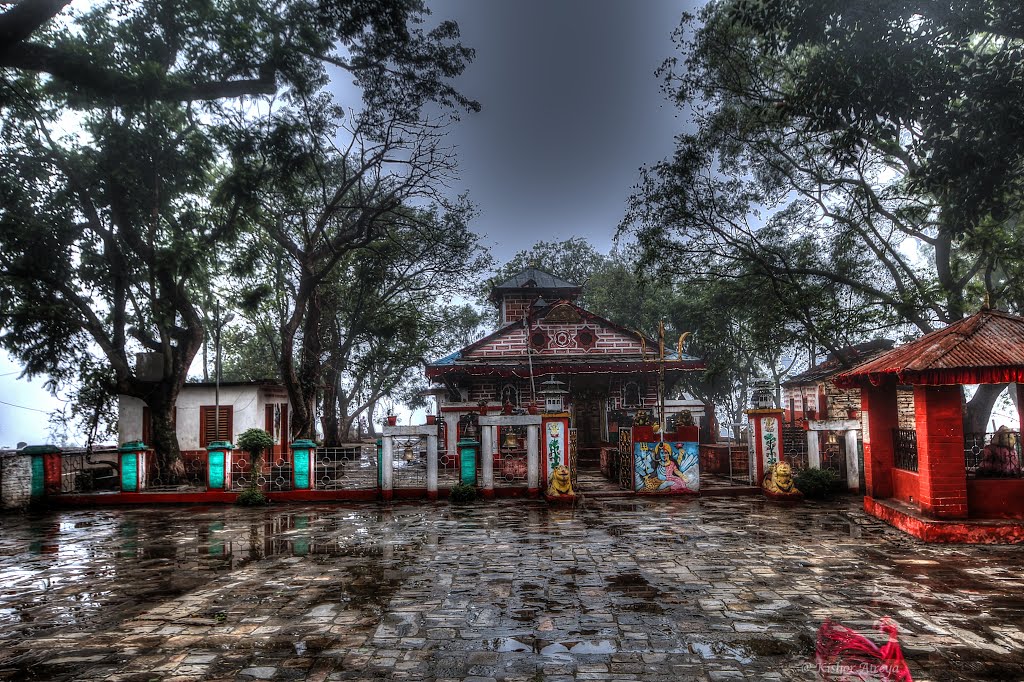
View on WikipediaDoti District (Nepali: डोटी जिल्ला pronounced [ɖoʈi] ⓘ), part of Sudurpashchim Province, is one of the seventy-seven districts of Nepal. This district, with Silgadhi as its headquarters, covers an area of 2,025 square kilometres (782 sq mi) with a population of 207,066 in 2001 and increasing marginally to 211,746 in 2011.[1]
Key Information


History
[edit]Doti was a medieval kingdom of Kumaon. It was founded by Niranjan Malla Dev, the last son of the Katyuri dynasty and younger brother of Abhay Pal of Askot. Previously, the area between Ramganga in the west and the Karnali River in the east was under the control of the Raikas (rulers of the Doti kingdom, alternately Kumaun or Rainka Maharaj).[2]
Ancient Doti was a part of Kumaon Kingdom, Now remaining Kumaon region is part of Uttrakhand a state in modern-day india, Nepal's neighboring country. Kingdom of Kumaon lost Doti during the expansion of Nepal Kingdom in 1790. It was formed after the Katyuri Kingdom's disintegration during the 13th century.[3] Doti was one of eight different princely states formed after the disintegration, and all claim Katyuri heritage.[4] The seven other known states are:
- Baijnath-Katyuri
- Dwarahat
- Baramandal
- Askot
- Sira
- Sora
- Sui (Kali Kumaon)
The Katyuri Kingdom's dissolution is attributed to the invasion of Khas Kings Ashoka Challa and Krachalla, from the Karnali zone (Dullu) in 1191 and 1223 respectively.[5] Later, the whole land between Ramganga in the west (Uttarakhand) and the Karnali in the east (which divides the far western region from other parts of Nepal), came under the Raikas' rule — after the establishment of the Katyuri's dynastic Raikas Doti. Brahma Dev Mandi at Kanchanpur; a district within Mahakali, was established by Katyuri King Brahma Dev.
Raikas of Doti and their lineage
[edit]Historical evidence [6] of the following raikas has been discovered:
- Niranjan Malla Dev (founder of Doti Kingdom beginning of the 13th century)
- Nagi Malla (1238)
- Ripu Malla (1279)
- Nirai Pal (1353) may be from Askot as historical evidence from 1354 AD relating to him has been found in Almora.[7]
- Nag Malla (1384)
- Dhir Malla (1400)
- Ripu Malla (1410)
- Anand Malla (1430)
- Balinarayan Malla (1400)[8]
- Sansar Malla (1442)
- Kalyan Malla (1443)
- Suratan Malla (1478)
- Kriti Malla (1482)
- Prithivi Malla (1488)
- Medini Jay Malla (1512)
- Ashok Malla (1517)
- Raj Malla (1539)
- Arjun Malla/Shahi (1500 [8])
- Bhupati Malla/Shahi (1558)
- Sagaram Shahi (1567)
- Hari Malla/Shahi (1581; last Raika of Sira, and the adjoining part of Nepal[8][9])
- Rudra Shahi (1630)
- Vikram Shahi (1642)
- Mandhata Shahi (1671)
- Raghunath Shahi (1690)
- Hari Shahi (1720)
- Krishna Shahi (1760)
- Deep Shahi (1785)
- Prithivi Pati Shahi (1790; He had fought against the Nepali army and also with the British in 1814 AD)[10][11]
Conflict with Kingdom Of Nepal
[edit]The historic place of war between the Doti Kingdom and Nepal kingdom during the period of Expanding Kingdom of Nepal in 1790, is Nari-Dang which lies on the bank of the Seti River and Dumrakot was the base of the Doti Kingdom during the fighting against the Gorkhalis.[12]
Doti was captured by Nepali/Gorkhali forces, and the Nepali rulers went on to destroy several historical sites in Doti — attempting to cover its legendary bravery and tenacity.[12] The Dotyali people were also subject to ethnic prejudice, and were frequently excluded from government jobs and offices of state.[12] Somehow in 1950, a few Dotyalis established their identities as national heroes based solely on their courage, daring, and contribution to their country.[12] Noted among them are Martyr Dashrath Chand Ministry of Home Affairs, Martyr Bhim Dutta Pant Ministry of Home Affairs, and K.I. Singh,[13][14] a revolutionary leader who later became prime minister.
Geography and climate
[edit]| Climate Zone[15] | Elevation Range | % of Area |
|---|---|---|
| Lower Tropical | below 300 meters (1,000 ft) | 0.1% |
| Upper Tropical | 300 to 1,000 meters 1,000 to 3,300 ft. |
22.2% |
| Subtropical | 1,000 to 2,000 meters 3,300 to 6,600 ft. |
58.8% |
| Temperate | 2,000 to 3,000 meters 6,400 to 9,800 ft. |
17.6% |
| Subalpine | 3,000 to 4,000 meters 9,800 to 13,100 ft. |
1.2% |
Demographics
[edit]| Census year | Pop. | ±% p.a. |
|---|---|---|
| 1981 | 153,135 | — |
| 1991 | 167,168 | +0.88% |
| 2001 | 207,066 | +2.16% |
| 2011 | 211,746 | +0.22% |
| 2021 | 205,683 | −0.29% |
| Source: Citypopulation[16] | ||
At the time of the 2021 Nepal census, Doti District had a population of 204,831. 10.79% of the population is under 5 years of age. It has a literacy rate of 70.74% and a sex ratio of 1188 females per 1000 males. 64,367 (31.42%) lived in municipalities.[17]
Khas people make up a majority of the population with 95% of the population. Chhetris make up 60% of the population, while Khas Dalits make up 24% of the population. Hill Janjatis, mainly Magars, are 4% of the population.[18]
- Doteli (89.1%)
- Nepali (7.30%)
- Magar Kham (1.35%)
- Magar Dhut (1.00%)
- Others (1.26%)
At the time of the 2021 census, 89.09% of the population spoke Doteli, 7.30% Nepali, 1.35% Magar Kham and 1.00% Magar Dhut as their first language.[19] In 2011, 6.8% of the population spoke Nepali as their first language.[20]
Administration
[edit]The district consists of nine municipalities, out of which two are urban municipalities and seven are rural municipalities. These are as follows:[22]
- Dipayal Silgadhi Municipality
- Shikhar Municipality
- Purbichauki Rural Municipality
- Badikedar Rural Municipality
- Jorayal Rural Municipality
- Sayal Rural Municipality
- Aadarsha Rural Municipality
- Dr. K. I. Singh Rural Municipality
- Bogatan Fudsil Rural Municipality
Former Village Development Committees
[edit]Prior to the restructuring of the district, Doti District consisted of the following Village development committees:

- Banalek
- Banja Kakani
- Barchhen
- Basudevi
- Bhawardanda
- Bhadhegaun
- Bhumirajmandau
- Changra
- Chhapali
- Chhatiwan
- Dahakalikasthan
- Daud
- Dhanglagau
- Dhirkamandau
- Durgamandau
- Gadasera
- Gaguda
- Gaihragaun
- Ganjari
- Ghanteshwar
- Girichauka
- Jijodamandau
- Kadamandau
- Kalena
- Kalikasthan
- Kanachaur
- Kapalleki
- Kedar Akhada
- Khatiwada
- Khirsain
- Ladagada
- Lamikhal
- Lana Kedareshwar
- Latamandau
- Lakshminagar
- Mahadevsthan
- Mannakapadi
- Mudabhara
- Mudhegaun
- Nirauli
- Pachanali
- Pokhari
- Ranagaun
- Sanagaun
- Saraswatinagar
- Satphari
- Simchaur
- Tijali
- Tikha
- Tikhatar
- Toleni
- Baglekh
- Barpata
See also
[edit]References
[edit]- ^ "National Population and Housing Census 2011(National Report)" (PDF). Central Bureau of Statistics. Government of Nepal. November 2012. Archived from the original (PDF) on 2013-04-18.
- ^ Badri Datta Pande; History of Kumaun (1937)
- ^ Bhoj Raj Bhattrai. A Historey of Doti Kingdom.
- ^ Prof.Dr. Jay Raj pant wrote "Far-Western region of Nepal is called Doti Culturally " : In History of Doti Kingdom (2013)
- ^ Yaswant Singh Kathoch. A New History of Ittarakhand.
- ^ Badri Dutt Pandey. History of Kumaun.
- ^ Advin T. Atkinson (Translated by Ramesh Thapaliyal) (2003). "An old stone has found on the hills of Almora in which name Niraipal and 1348 written". Himalayan Gazetteer Hindi Edition. ISBN 8190100130. p. 267.
- ^ a b c Dr. Ram Singh; A New History of Uttarakhand(2006).Mall Raikas of Sira.
- ^ Advin T. Atkinson; Himalayan Gazetteer; (Translated by Ramesh Thapaliyal) Hindi Edition (2003) ISBN 8190100130;..Page 285..Rudra Chand had captured whole territory east of kaliriver in 1581 along with Sira.
- ^ Advin T. Atkinson(2003). "Doteli King and East india company agreed to help each other". Himalayan Gazetteer Hindi Edition. p. 380.
- ^ Raja Ram Subedi (1997). History of Karnali Region. Subedi has mentioned Pritivipati Shah went to pilibhit and offered his service to British india.
- ^ a b c d "History of Nepal". T.R.Vaidya Publications. Archived from the original on 2005-02-09. Retrieved 2008-01-31.
- ^ Time magazine. 5 August 1957.
- ^ The New York Times. 6 October 1982. State Guest of PR of China in 1952 for three years during the rule of Mao Tse-tung & Chou en Lai
- ^ The Map of Potential Vegetation of Nepal - a forestry/agroecological/biodiversity classification system (PDF), . Forest & Landscape Development and Environment Series 2-2005 and CFC-TIS Document Series No.110., 2005, ISBN 978-87-7903-210-1, retrieved November 22, 2013
- ^ "NEPAL: Administrative Division". www.citypopulation.de.
- ^ "Provincial/District/Local reports: Sudurpaschim Province" (PDF). Census Nepal 2021. Central Bureau of Statistics.
- ^ a b "Table 1: Caste/Ethnicity and sex". Census Nepal 2021. Central Bureau of Statistics. Retrieved 2024-03-16.
- ^ a b "Table 5: Mother tongue and sex". Census Nepal 2021. Central Bureau of Statistics.
- ^ NepalMap Language [1]
- ^ "Table 5: Religion and sex". Census Nepal 2021. Central Bureau of Statistics. Retrieved 2024-03-16.
- ^ "स्थानिय तह" (in Nepali). Ministry of Federal Affairs and General Administration. Retrieved 1 September 2018.
- Sources
- "Districts of Nepal". Statoids.
- A New History of Uttarakhand by Y.S. Kathoach
- Dotiyali language
Places adjacent to Doti District | |
|---|---|
29°16′N 80°56′E / 29.267°N 80.933°E
| International | |
|---|---|
| National | |
| Other | |
Doti District
View on GrokipediaHistory
Origins and the Raika Kingdom
The region encompassing modern Doti District emerged as a distinct polity following the collapse of the Katyuri Kingdom in the Kumaon region during the early 13th century, precipitated by invasions from Khas kings, including Ashoka Challa in 1191 and Krachalla in 1223.[5] This fragmentation allowed for the formation of smaller principalities from former Katyuri territories, with Doti establishing itself as one such entity in the far-western Himalayan foothills, spanning areas between the Kali River and adjacent river valleys.[5] The etymology of "Doti" likely derives from "Dovati," denoting land situated between two rivers, reflecting its geographical positioning amid riverine terrain conducive to early settlement and agriculture.[5] Niranjan Malla Dev, described in historical accounts as the son of the last Katyuri ruler and younger brother of Abhay Pal (ruler of Askot), is credited with founding the Doti kingdom around the mid-13th century.[5] [6] His establishment of the polity marked a shift from the broader Katyuri domain to localized Khas-influenced governance, leveraging the power vacuum to assert control over fertile valleys and trade routes in what is now far-western Nepal.[7] The Raika dynasty, with rulers titled Raikas (or Rainka Maharaj), governed Doti as a semi-autonomous kingdom characterized by feudal structures adapted from Katyuri and Khas traditions.[7] Early Raikas expanded their domain by subduing the Khas Malla rulers of the neighboring Karnali Zone, thereby securing territorial integrity and economic resources such as timber, herbs, and pastoral lands essential for sustaining a warrior aristocracy.[7] This consolidation fostered a stable medieval polity reliant on agrarian surplus and intermittent warfare, with administrative centers like Ajemeru serving as early capitals, though precise boundaries fluctuated amid regional power struggles.[7] Historical records of the era remain fragmentary, drawn primarily from local chronicles and inscriptions, underscoring the kingdom's role as a buffer state between emerging powers in Kumaon and the Nepalese hills.[5]Lineage of Raikas and Medieval Governance
The Raika dynasty emerged in the 13th century following the disintegration of the Katyuri Kingdom, with Niranjan Malla Dev establishing Doti as an independent realm. As the son of the last Katyuri ruler and younger brother of Abhay Pal (ruler of Askot), Niranjan Malla Dev founded the kingdom amid the fragmentation of Katyuri territories into multiple principalities.[7] [4] The Raikas, as the rulers were titled (also rendered as Rainka Maharaj), traced their legitimacy to this Katyuri heritage while adopting Shahi surnames in later generations.[7] Successive Raikas expanded Doti's domain through military campaigns, notably defeating the Khas Malla rulers of the Karnali region to secure control over far-western territories stretching from the Ramganga River in the west to the Karnali in the east.[6] Inscriptions provide evidence of key figures: Niraya Pal asserted sovereignty around 1352 CE, while Naga Malla subsequently consolidated authority over the broader Karnali area.[8] By the late medieval period, Raika Mandhata Shahi issued a copper-plate grant in Saka Era 1612 (approximately 1690 CE), documenting land endowments in the Khas language using Devanagari script, indicative of ongoing administrative practices.[9] Medieval governance under the Raikas operated as a hereditary monarchy within the Baise Rajya confederation of western hill states, with the Raika exercising centralized authority supported by regional chieftains and feudal obligations.[7] Administration relied on copper-plate inscriptions for recording grants, revenue collection, and judicial decisions, mirroring systems in contemporaneous Kumaon and Karnali polities.[9] Defensive fortifications, such as those at Ajemeru, underscored the kingdom's focus on border security against incursions, including a 16th-century Mughal expedition led by Hussain Khan.[4] This structure sustained Doti's autonomy until the Gorkha expansions of the late 18th century.Conflicts and Integration with the Kingdom of Nepal
The Kingdom of Doti, ruled by the Raika dynasty as one of the Baise Rajya principalities in western Nepal, faced military pressure from the expanding Gorkha Kingdom following the death of Prithvi Narayan Shah in 1775. Under his successors, particularly during the reign of Rana Bahadur Shah, Gorkha forces targeted the far-western kingdoms to consolidate control over fragmented hill states. Doti's rulers mounted resistance against these incursions, leveraging the rugged terrain and alliances with neighboring Kumaon to defend their sovereignty.[10][4] Key conflicts erupted in the late 18th century, with a pivotal battle occurring at Nari-Dang on the banks of the Seti River in 1790, marking a historic clash between Doti forces and Gorkha troops during the broader unification campaigns. This engagement highlighted Doti's defensive efforts, but Gorkha military superiority, bolstered by disciplined infantry and artillery, prevailed in subsequent confrontations, including a fierce battle at Dumrakot. Raika Prithvi Pad Shahi, the last independent king of Doti, was forced into exile following these defeats, signifying the collapse of Doti's autonomy.[4][11] Annexation of Doti into the Kingdom of Nepal occurred around 1790, integrating its territories administratively under Gorkha governance and ending the Raika lineage's rule. While some local accounts suggest lingering semi-autonomy until 1847, when final merger and deposition of residual royal claims took place, the primary conquest aligned with Gorkha's western expansion phase. This incorporation subjected Doti to central taxation, military conscription, and land reforms typical of Gorkha administration, though local customs persisted under appointed governors. The region's retention by Nepal after the Anglo-Nepalese War (1814–1816), unlike territories west of the Kali River ceded to British India via the Treaty of Sugauli, solidified its place within the unified kingdom.[10][12][4]Geography
Location and Topography
Doti District is located in Sudurpashchim Province in the far-western region of Nepal, with its administrative headquarters at Dipayal Silgadhi. Centered at approximately 29°15′N 80°55′E, the district spans 2,025 square kilometers and shares borders with Baitadi and Dadeldhura districts to the west, Bajhang and Achham to the north, Kailali to the south, and Surkhet to the east.[3][13][14] The topography of Doti is predominantly hilly, forming part of Nepal's mid-hills region, with rolling hills, deep river valleys carved by waterways like the Seti River, and pockets of fertile plains suitable for agriculture. Elevations vary significantly, starting from around 600 meters in lower valleys to exceeding 3,280 meters at the district's high points, with an average elevation of 1,451 meters across the terrain.[3][15][16][17]Climate and Natural Resources
Doti District experiences a temperate highland tropical climate characterized by dry winters, with annual mean temperatures averaging 22.84°C.[18] Precipitation totals approximately 1145 mm annually, with the majority—around 802 mm—occurring during the monsoon season from June to September.[18] Climatic conditions vary by elevation, ranging from subtropical in lower valleys to temperate in higher hills, where the district's average elevation reaches about 1451 meters, though the headquarters at Dipayal Silgadhi sits at 563 meters.[3][19][20] The district's natural resources are dominated by extensive forests, which cover approximately 71.3% of the land area, supporting biodiversity and providing timber, fuelwood, and non-timber products essential for local livelihoods.[21] Water resources include rivers such as the Seti and Sailigad, which facilitate irrigation, traditional water mills for grain processing, and potential hydropower development, though spring sources have shown declining discharge amid broader Himalayan trends.[22][23] Agricultural land supports subsistence farming of crops including rice, maize, wheat, millet, potatoes, and cash crops like oranges (produced on 313 hectares yielding 3,000 metric tonnes in recent years) and kiwi (64.96 tonnes from 28 hectares).[24][25] Mineral deposits, primarily iron ore with potential for base metals and gold, occur in limited quantities and have historically supported small-scale mining.[26][27] Despite these assets, resource dependency contributes to low agricultural productivity, exacerbated by land abandonment and conversion of arable areas to pastures.[28]Environmental Features and Hazards
Doti District exhibits a predominantly hilly topography characterized by rolling hills, deep river valleys, and pockets of fertile plains, which support agricultural activities amid scenic landscapes.[3] Forests cover approximately 71.3% of the district's total land area, primarily consisting of mid-hill vegetation types that harbor local biodiversity and serve as vital resources for livelihoods.[21] [29] The region's temperate climate, marked by monsoon-influenced wet summers and drier winters, fosters diverse ecosystems but also amplifies susceptibility to seasonal environmental disruptions.[30] Natural hazards in Doti are exacerbated by its steep slopes, fragile geology, and heavy monsoon rainfall, making landslides and floods recurrent threats.[30] For instance, landslides in October 2021 claimed four lives in the district, highlighting the risks to remote settlements.[31] Seismic activity poses another major danger, as evidenced by the 6.6 magnitude earthquake on November 9, 2022, centered near Doti, which killed at least six people, injured seven, and damaged over two dozen houses across affected wards.[32] [33] [34] Forest fires, driven by dry conditions and human activities, frequently occur in the extensive wooded areas, threatening vegetation cover and exacerbating soil erosion.[29] The district's high social vulnerability stems from poverty, limited infrastructure, and resource dependency, intensifying impacts from these events.[35][30]Demographics
Population Trends and Census Data
According to the National Population and Housing Census conducted by Nepal's Central Bureau of Statistics, Doti District had a population of 204,831 in 2021, down from 211,746 in 2011.[36] This represents a net decline of approximately 6,915 residents over the decade, or an average annual growth rate of -0.32%.[36] Historical census data indicate slower growth prior to 2011. The 2001 census recorded 207,066 inhabitants, reflecting a modest increase of about 2.2% over the subsequent decade to 2011.[36] These figures, derived from Nepal's decennial enumerations, highlight a pattern of initial expansion followed by stagnation or reversal in the district's far-western location, potentially linked to broader national trends of rural-to-urban migration and international labor outflows, though district-specific emigration data remain limited in official releases.| Census Year | Population | Change from Previous Census |
|---|---|---|
| 2001 | 207,066 | - |
| 2011 | 211,746 | +4,680 (+2.3%) |
| 2021 | 204,831 | -6,915 (-3.3%) |
Ethnic and Religious Composition
Doti District is predominantly inhabited by Khas-Arya ethnic groups, with Chhetri forming the largest segment of the population, alongside Hill Brahmins (Bahun), Thakuri, and Dalit communities including Kami, Sarki, and Damai. Smaller proportions consist of indigenous Janajati groups such as Magar. These groups reflect the historical Khas dominance in the far-western hills of Nepal, where caste hierarchies and endogamous practices persist.[3][38] Religiously, the district is overwhelmingly Hindu, aligning with the Khas ethnic majority's adherence to Hinduism. The 2021 National Population and Housing Census recorded a total population of 204,831, with the following distribution:| Religion | Population | Percentage |
|---|---|---|
| Hinduism | 202,717 | 98.97% |
| Buddhism | 1,380 | 0.67% |
| Prakriti | 305 | 0.15% |
| Christianity | 295 | 0.14% |
| Islam | 114 | 0.06% |
| Kirat | 13 | <0.01% |
| Other | 7 | <0.01% |