Recent from talks
Nothing was collected or created yet.
Doune
View on Wikipedia
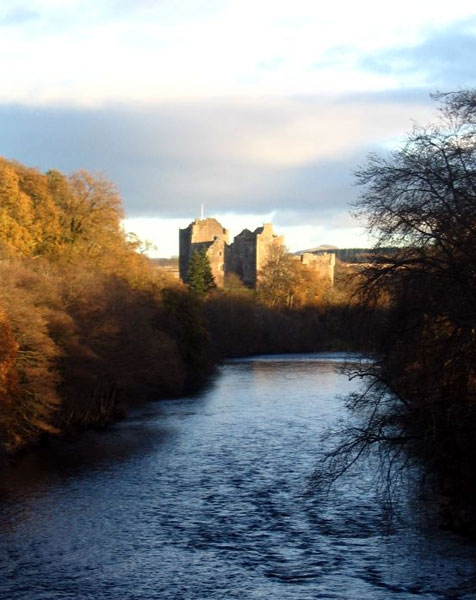
Doune (/duːn/; from Scottish Gaelic: An Dùn, meaning 'the fort') is a burgh within Perthshire. The town is administered by Stirling Council. Doune is assigned Falkirk postcodes starting "FK". The village lies within the parish of Kilmadock and mainly within the area surrounded by the River Teith and Ardoch Burn.
Key Information
In the 2001 Scottish census, 2.75% residents of Doune could speak Scottish Gaelic.[2]
Doune has a small primary school with 183 pupils on the roll (June 2016), drawn from a catchment area which extends outside the town, especially to the north. It is located on the site of Doune Roman fort.[3] Gaelic is taught in Primary 1–7 and Spanish is now taught from P5 upwards .[4]
History
[edit]The town is dominated by Doune Castle, built in the late 14th century. Architecturally it is a mixture of fortress and manor house.[5]
Bonnie Prince Charlie passed through Doune in 1745.[6]
Doune was also famous for its manufacture of pistols, but this eventually ceased due to the competition of manufacturers in, for example, Birmingham where production was cheaper. Today, these pistols are collected and can be found in major museums, including the Museum of Scotland in Edinburgh. Allegedly a Doune pistol fired the first shot of the American War of Independence.[7]
Throughout the parish the names most often met with are Campbell, Stewart, Ferguson, Morrison, McAlpine, McLaren, MacDonald, Mathieson and Cameron.[8]
Land east of Doune was owned by the Stirling of Keir family (who still own a lot of the land around Keir House, but sold the house itself), and the current owner of the Keir Estates is the politician Archie Stirling. One member of the family, SAS founder David Stirling, is memorialised at a monument on the Keir land near Doune known as the Hill o' Rou.
Sports
[edit]The local amateur football team Doune Castle AFC play in the Caledonian Amateur Football League. The local cricket team play in the Strathmore & Perthshire Cricket Union.
Archaeology
[edit]
Doune is well-known for its pistols and Roman remains, but the Doune area has been inhabited a lot longer and many burial mounds and standing stones supporting this are clearly evident and plentiful. To the rear of Doune where the ponds and the Doune Riggs housing development now sits was known locally as Currachmore. This area contained the bluebell wood, an area popular with walkers; it was also part of the Doune Golf course. This area was quarried and the sand coming from here was used in the construction of Longannet. Also lost to the quarrying was a mound measuring 150 yards (140 metres) long, 100 yd (90 m) wide and 30 ft (9 m) high, known locally as the Round Wood. At the time of quarrying, a stone cist or coffin was uncovered and in it were remains of a small boy aged 6, with a small stone axe. He was identified as one of the Beaker people of the early Bronze Age, c. 1800 BC.[9]
The remains of a Roman fort were excavated by Headland Archaeology.[10][3] Three ditches and the base of a rampart were investigated comprising part of the defence works.[3] Set into the back of the rampart five circular stone bread ovens were located. Running behind the ovens a gravel track was interpreted as the intervallum way (one of the internal roads of the fort). The foundations of a building that it is thought served as the fort’s hospital were also uncovered and an iron-smelting shaft furnace, a first for Roman Scotland. Fragments of samian ware and amphorae were recovered dating to the Flavian period and the first Roman incursion into Scotland (from 79 AD to the mid-80s AD).[3] The remains of the Roman fort are a scheduled monument.[11]
Folklore
[edit]As in other Celtic lands, Doune has tales of fairies. One place associated with such folklore is Ternishee, a small wood east of the Annat chapel, above Doune Lodge, 1+1⁄2 miles (2.5 kilometres) from Doune. Its name comes from the Scottish Gaelic: tìr na sìdhe, lit. 'land of the fairies'. Fairy dancing parties are recounted on the Fairy Knowe, a hillock on the right bank of the Ardoch, 1⁄2 mile (800 metres) east of Doune. Near the Bridge of Teith, on the low road to Callander, a burial mound called Tullochanknowe is said to be a favourite haunt of the fairies.[12]
Other information
[edit]Doune Speed Hillclimb is the most prestigious hillclimb motorsport course in Scotland, and hosts a round of the British Hill Climb Championship each year.
The town used to be served by Doune railway station.
Doune has often been used as a filming location, most famously for Monty Python and the Holy Grail which was filmed at Doune Castle. The castle has also been used for major TV series, most notably Ivanhoe, Game of Thrones and Outlander.
References
[edit]- ^ "Population estimates for settlements and localities in Scotland: mid-2020". National Records of Scotland. 31 March 2022. Retrieved 31 March 2022.
- ^ "Comparative Population Profile: Callander Locality". Scotland's Census Results Online. 29 April 2001. Archived from the original on 27 May 2014. Retrieved 27 May 2014.
- ^ a b c d Hatherley, Candy; Evans, Jeremy; Goldberg, Martin; Hartley, Kay F.; Hastie, Mhairi; Holmes, Nicholas M. McQ.; Hunter, Fraser; Lochrie, Julie; Monteil, Gwladys; Photos-Jones, Effie; Timpany, Scott (12 June 2020). "Doune Roman fort, Stirlingshire: Excavations in 1999, 2008 and 2010". Scottish Archaeological Internet Reports. 92: 1–62. doi:10.9750/issn.2056-7421.2020.92. ISSN 2056-7421.
- ^ Doune Primary School on the website of Stirling Council
- ^ Historic Environment Scotland. "Doune Castle (SM12765)". Retrieved 19 February 2019.
- ^ MacKay, Moray S. (1953). Doune Historical Notes. Forth Naturalist and Historian Board. p. 35. ISBN 0950696250.
{{cite book}}: ISBN / Date incompatibility (help) - ^ "Doune Pistol Factory". Callander Enterprise. Archived from the original on 24 March 2010. Retrieved 18 April 2010.
- ^ MacKay (1953), p. 102.
- ^ MacKay (1953), p. 97.
- ^ Moloney, C. (1999). "Doune Primary School, Doune (Kilmadock Parish), Roman Fort". Discovery and Excavation in Scotland. p. 87.
- ^ Historic Environment Scotland. "Doune Roman Fort, fort 60m S of Doune Primary School (SM12757)". Retrieved 19 February 2019.
- ^ MacKay (1953), pp. 104–105.
External links
[edit]Doune
View on GrokipediaGeography and Demographics
Location and Topography
Doune is situated at geographic coordinates 56°11′24″N 4°03′11″W, placing it in the Stirling council area of Scotland, historically part of Perthshire.[7] The village lies within the parish of Kilmadock, approximately 8 miles northwest of Stirling city, along the A84 road that connects Stirling to Callander.[8][9] The settlement is surrounded by the River Teith to the south and the Ardoch Burn to the north, where the two waterways converge, forming a natural boundary and influencing the local hydrology.[8][10] Doune occupies a low-lying position in the Carse of Stirling, an extensive fertile flood-plain of the River Forth characterized by flat, agricultural land that was historically marshy and now supports rich farmland.[11] This topography rises gently from the rivers, providing expansive views toward the nearby Trossachs hills to the west, which contribute to a moderated local climate with mild winters and varied precipitation patterns.[12][13] Proximity to Doune Castle, a prominent medieval landmark overlooking the River Teith, enhances the area's scenic and historical character without altering its predominantly rural, riverine setting.[14]Population and Language
As of mid-2020, Doune had an estimated population of 2,200 residents, according to National Records of Scotland locality estimates.[15] The 2022 census recorded 2,184 people living in the locality, reflecting modest growth from the 2011 census figure of 1,840 and indicating a recovery from a slight decline over the previous decade.[2] Historical trends show steady expansion since the early 2000s, driven by the village's appeal as a commuter settlement near Stirling, though growth remains limited compared to urban areas in the region. As of the 2022 census, the population was 2,184; more recent locality estimates are pending.[16] Linguistically, Doune's residents primarily speak English, with Scottish Gaelic maintaining a minor presence. Gaelic-medium education is available through Stirling Council, supporting language preservation in the broader area, though uptake in Doune itself is low given the small number of fluent speakers. In the 2022 census, Gaelic speakers remained a small minority in Scotland overall (under 1%), with low uptake in Doune.[17][18] Demographically, Doune's population is predominantly White, comprising over 98% of residents in the 2022 census.[2] The village exhibits aging trends typical of rural Stirling, where 21.3% of the population is aged 65 and over (as of 2022)—higher than Scotland's national average of 20.1% for 65+—reflecting broader rural patterns of out-migration among younger residents and in-migration of retirees.[19]History
Early and Medieval History
The area around Doune shows evidence of human activity dating back to the Bronze Age, with a notable Beaker period burial discovered in what is now Bluebell Wood (formerly Doune Ponds). This c. 1800 BC interment contained the remains of a young boy, approximately six years old, accompanied by a stone axe, indicating early funerary practices associated with the Beaker people.[20] Roman influence in the region is evidenced by a fort established on Castle Hill during the Flavian period (AD 69–96), covering about two hectares and featuring a triple-ditch defensive system, gravel roads, buildings, and artifacts such as pottery and metalworking remains. This garrison site, strategically positioned near the River Teith and along Dere Street, served as a military outpost until its abandonment and burning in the late AD 80s, with no subsequent Roman reoccupation during the Antonine period.[20] Settlement in Doune emerged more substantially in the medieval period, building on earlier fortifications. An initial castle structure likely dates to the 13th century, which may have sustained damage during the Wars of Scottish Independence (1296–1328), reflecting the site's strategic importance amid the conflicts led by Robert the Bruce and his successors.[4] In the late 14th century, Doune developed as a burgh under the influence of the Stewart family, closely tied to the reign and legacy of Robert the Bruce, whose grandson Robert Stewart, 1st Duke of Albany, oversaw the reconstruction of the castle around the 1380s. This rebuilding transformed the site into a hybrid fortress and manor house, featuring a large gatehouse tower, courtyards, and domestic ranges suited to a powerful noble's residence, while the surrounding settlement grew with houses clustering for protection and trade.[4][5]Post-Medieval Developments
During the 16th and 17th centuries, Doune's economy thrived on its position along Highland cattle droving routes, serving as a key market for livestock trade between the Highlands and Lowlands. This activity spurred the growth of related industries, including leather working and the production of traditional items such as sporrans and shoes, contributing to the village's development as a bustling trade center.[5] From the mid-17th century, Doune gained prominence for its high-quality flintlock pistol production, which began around 1646 with gunsmith Thomas Caddell establishing the local industry. These pistols, characterized by their distinctive scroll or ram's horn butts, fluted barrels, and Celtic engravings, were crafted by notable families such as the Murdochs, Christies, and Campbells, earning a reputation across Europe for elegance and craftsmanship. Doune pistols played a notable role in the American War of Independence, with examples like those made by John Murdoch reputedly firing the first shots at the Battle of Lexington in 1775. However, the industry declined by the late 18th century due to reduced demand following the 1746 Disarming Act, which prohibited Highland dress and weapons after the Jacobite defeat, and increasing competition from larger English manufacturers; by the early 19th century, traditional production had ceased. The legacy of pistol-making influenced Doune's early economy, fostering skilled metalworking traditions that persisted in local crafts.[21][22] In the Jacobite era, Doune featured prominently during the 1745 Rising when Bonnie Prince Charlie and his followers occupied Doune Castle as a strategic stronghold, leveraging its formidable defenses amid their campaign to restore the Stuart monarchy. The castle served as a base for Jacobite forces before they advanced southward, highlighting Doune's position on key routes through central Scotland.[23] The 19th century marked industrial shifts in Doune and its vicinity, transitioning from arms production to textile manufacturing, exemplified by the establishment of the Deanston Cotton Mill in 1785 along the River Teith, which powered operations and spurred village growth. Under manager James Smith from 1806, the mill expanded significantly, becoming a model of early industrial efficiency and employing hundreds in spinning and weaving until its closure in 1965, when it was repurposed for whisky distilling. Concurrently, Doune's administrative status evolved from its 1611 charter as a burgh of barony—granting market rights—to a police burgh in 1890 under the General Police and Improvement (Scotland) Act 1862, introducing formalized local governance for policing, sanitation, and infrastructure improvements.[24] In the 20th and 21st centuries, Doune underwent significant administrative changes with the Local Government (Scotland) Act 1973, which abolished burghs and counties effective 16 May 1975, integrating the former Burgh of Doune into the new Stirling District within the Central Region. This reform streamlined services across former Perthshire and Stirlingshire areas, with Doune remaining under Stirling's jurisdiction following further restructuring in 1996 that created unitary council areas.Governance and Economy
Local Administration
Doune is administered as part of the Stirling council area, one of Scotland's 32 unitary local authorities, which was established in 1975 under the Local Government (Scotland) Act 1973 and became a unitary authority following the Local Government etc. (Scotland) Act 1994.[25] Prior to this reorganization, Doune held burgh status from 1890 until 1975, after which its boundaries were integrated into the new district structure.[26] At the local level, the Kilmadock (Doune and Deanston) Community Council serves as the statutory representative body for the area, consulting with residents on matters such as planning applications, community facilities, and local services while communicating priorities to Stirling Council.[27] The council, which covers Doune, Deanston, Buchany, and surrounding rural areas, develops action plans to address community needs, including environmental and infrastructure concerns, and participates in statutory consultations under the Community Empowerment (Scotland) Act 2015. For elected representation, Doune falls within Ward 2 (Forth and Endrick) of Stirling Council, a multi-member ward that elects three councillors to the 23-seat authority using the single transferable vote system.[28] Current councillors for the ward include representatives from the Scottish Labour Party, Scottish National Party, and Scottish Conservative and Unionist Party, who address local issues such as housing and transport within council committees.[29] At the national level, Doune is part of the Stirling constituency for the Scottish Parliament, represented by MSP Evelyn Tweed (SNP) since 2021, who has announced she will not seek re-election in 2026, and the Stirling and Strathallan constituency for the UK Parliament, held by MP Chris Kane (Labour) following the 2024 general election.[30][31] In the 2020s, recent developments in Doune's administration have emphasized community empowerment under Scottish localism policies, including the adoption of a Local Place Plan in 2022, which outlines resident-led proposals for land use and development in partnership with Stirling Council.[32] This initiative, supported by the Kilmadock Development Trust and Community Council, builds on the 2015 Act to enhance participatory budgeting and asset transfer opportunities, such as community woodland management projects.[33] The 2023 Kilmadock Action Plan further integrates these efforts, focusing on sustainable growth and resilience in response to post-pandemic recovery priorities. On 10 November 2025, the Scottish National Party took control of Stirling Council administration, with Cllr Susan McGill appointed as leader.[34]Economic History and Current Industries
Doune's economy in the 17th and 18th centuries was notably shaped by the production of high-quality flintlock pistols, a craft introduced by gunsmith Thomas Caddell in 1646 and which became a signature industry for the village. These ornate weapons, often featuring engraved barrels and walnut stocks, were prized by Highland clans and exported widely, supporting local artisans and contributing to Doune's reputation as a center for fine gunsmithing. However, by the early 19th century, competition from larger English manufacturers and cheaper imports led to the industry's decline, with many gunsmiths emigrating or shifting trades.[35][21] The Industrial Revolution brought new opportunities through the establishment of the Adelphi Cotton Mill in nearby Deanston in 1785, powered by the River Teith and creating a planned village for workers. At its peak in the 19th century, the mill employed over 1,000 people in spinning and weaving, drawing labor from Doune and bolstering the local economy amid Scotland's textile boom. Operations ceased in 1965 due to global competition, but the site was repurposed as Deanston Distillery in the late 1960s, reviving economic activity through whisky production using traditional floor malting and local spring water. Agriculture has long complemented these developments, with the fertile Carse of Stirling supporting mixed farming of barley for malting, livestock such as beef and sheep, dairy cattle, and specialty crops like Timothy hay.[36][37][38][39] In the modern era, Doune's economy has shifted toward services, with tourism emerging as a primary driver, attracting visitors to historic sites and the Deanston Distillery's tours and tastings. Small businesses in retail and hospitality thrive, supported by the village's proximity to Stirling and the Trossachs National Park, while light manufacturing persists in sectors like distilling. Post-2020 trends have encouraged remote work among residents, aligning with broader rural shifts in Scotland. Unemployment in the Stirling council area, which includes Doune, stood at approximately 3.2% in 2024, mirroring national averages and reflecting stable employment in these sectors. Community-led initiatives, such as the historic Doune Fairs and local markets, further sustain economic vitality by promoting artisanal goods and fostering resident entrepreneurship.[40][41][42][43]Landmarks and Archaeology
Doune Castle
Doune Castle is a well-preserved 14th-century courtyard castle located near the village of Doune in Stirling, Scotland, constructed primarily as a noble residence. Built in the late 14th century by Robert Stewart, 1st Duke of Albany and uncle to King James I, the castle was completed around 1400, with a prominent gatehouse added shortly thereafter.[4] Its architecture exemplifies late medieval Scottish design, featuring a striking 100-foot-high gatehouse serving as the lord's tower with an arched entrance and semi-circular projections for defense, alongside a separate kitchen tower.[44] The interior highlights include one of Scotland's best-preserved great halls, boasting a cathedral-like scale with a musicians' gallery, double fireplace, and carved oak screen, while the adjacent kitchen and servery areas reflect the castle's capacity for grand banquets.[4] Historically, the castle served as the luxurious seat of the Stewart earls, underscoring Albany's political influence as "Scotland's uncrowned king" during his regency from 1388 to 1420.[45] It later functioned as a royal residence, notably visited by Mary, Queen of Scots in 1566.[4] During the 17th century, its strategic position led to involvement in the Wars of the Three Kingdoms, where it was captured by Covenanter forces in 1645 and subsequently recaptured by Royalists in 1646, demonstrating its military significance.[4] By the early 19th century, the castle had fallen into ruin, but restoration efforts commenced in the 1880s under the 14th Earl of Moray, who repaired roofs, floors, and structural elements to halt decay.[4] Further conservation work continued into the 20th century, culminating in the castle being placed in state care in 1984 by the 20th Earl of Moray, after which it has been managed by Historic Environment Scotland.[46] Designated as a Category A listed building and a scheduled ancient monument, it benefits from ongoing preservation programs that balance historical integrity with public accessibility.[47][48] Today, Doune Castle is open to the public year-round, offering self-guided exploration of its interiors and grounds, with audio guides available in multiple languages and included in admission tickets to provide detailed historical context.[45] A visitor center at the entrance features a shop and exhibition space, while the site hosts annual events to engage the community. Its role as a filming location for various productions has further enhanced its appeal, drawing increased tourism.[45]Roman Fort and Prehistoric Sites
The Roman fort at Doune, located approximately 60 meters south of Doune Primary School, dates to the Flavian period of Roman occupation in Scotland, specifically between AD 80 and 86/87, and was occupied only briefly before abandonment.[49] This auxiliary fort, guarding the crossing of the River Teith, featured defensive elements such as three ditches and a turf rampart, along with internal structures including a cobbled intervallum road, timber cavalry barracks, and industrial facilities.[49] Notable among these were five circular ovens (2–3 meters in diameter) along the north-west side, used for bread baking and heated by wood, turf, or peat; a building initially interpreted as a hospital but later identified as a workshop; and an iron-smelting shaft furnace near the rampart, representing the first such discovery in Roman Scotland.[49] The site is protected as a Scheduled Monument under designation SM12757.[](https://portal.historicenvironment.scot/apex/f?p=1505:300:::::VIEWTYPE,VIE WREF:designation,SM12757) Archaeological excavations at the fort have been conducted intermittently since the late 20th century, with key digs in 1999, 2008, and 2010 led by Headland Archaeology within the grounds of Doune Primary School to inform development proposals.[49] These efforts uncovered evidence of deliberate backfilling and slighting upon abandonment, alongside artifacts detailed in a 2020 report by the Scottish Archaeological Internet Reports, including pottery, metalwork, and animal bones that illuminate daily military life and supply chains.[49] Earlier aerial surveys in 1983 by Professor J.K. St. Joseph first identified the fort's outline, confirming its role in the Flavian frontier system.[50] Prehistoric activity in the Doune area is evidenced by a Bronze Age child's burial discovered near the town, radiocarbon dated to approximately 1872–1547 cal BC (around 1800 BC), containing unburnt remains of a male aged 5–9 years, a miniature stone battle-axehead of quartz-rich sandstone, and two Food Vessels associated with Beaker-period traditions. This cist burial, reported in detail by McLaren (2004), highlights early social hierarchies, as the rare axehead suggests ascribed high status to the child, possibly linked to Continental influences in prehistoric Scotland. Additional prehistoric features, such as a linear ditch and four-poster structure predating the fort, were identified during Roman excavations, indicating longer-term settlement in the vicinity.[49] The Roman fort's remains provide crucial evidence of the extent and logistics of Roman military incursions into northern Britain during the Flavian era, while the prehistoric burial underscores Doune's role in Early Bronze Age funerary practices and genetic-cultural shifts.[49] Today, the fort site lies beneath the modern primary school, preserving its archaeological integrity despite urban overlay.[49]Culture, Folklore, and Media
Local Folklore
Local folklore in Doune draws heavily from the rich Celtic traditions of Perthshire, where fairies—known as the Sidhe or Tuatha Dé Danann—are depicted as an ancient race of invisible, eternally youthful beings residing in hills, mounds, and knolls. These supernatural entities are said to emerge at midnight for dances on dewy swards, enchanting mortals with music and processions, while their abodes serve as portals to an Otherworld of eternal beauty and peril. Tales emphasize respect for these sites to avoid abduction or changeling substitutions, with regional beliefs linking fairies to the spirits of the dead or pre-Christian pagan cults absorbed into Highland culture.[51] Specific local stories associate fairy activity with natural and ancient features around Doune, such as wooded areas and burial mounds believed to be gateways to the fairy realm, where revels and processions occur under the cover of night. In nearby Aberfoyle, the Fairy Knoll exemplifies this lore, tied to the 17th-century abduction of Reverend Robert Kirk by fairies after he documented their customs; similar traditions extend to Perthshire hillocks like those near Glenshee, once teeming with fairy folk before modern disturbances drove them underground. These narratives often connect to prehistoric mounds, interpreted as fairy dwellings that inspired cautionary tales of mortals entering at their own risk.[51] Historical legends further enrich Doune's supernatural heritage, particularly those surrounding the town's renowned pistol-makers, whose intricate flintlock weapons achieved legendary status for their quality and role in pivotal conflicts. Folklore claims a Doune pistol fired the opening shot in one of the pivotal conflicts, such as the 1745 Jacobite Rising or the American War of Independence, symbolizing the craftsmen’s enduring skill passed down through families like the Caddells since the 17th century. At Doune Castle, ghostly apparitions contribute to the eerie tales, including sightings of Mary Queen of Scots, who resided there during her exile, with reports of spirit orbs captured in photographs reinforcing the site's haunted reputation.[52][53] These oral traditions were meticulously preserved in 19th- and early 20th-century folklore collections, which captured Perthshire's fairy beliefs amid industrialization and cultural shifts. Works like J.F. Campbell's Popular Tales of the West Highlands (1862) and W.Y. Evans-Wentz's The Fairy-Faith in Celtic Countries (1911) documented similar Highland narratives, including fairy abductions, exorcisms of haunted sites like Balechan in Perthshire, and the Sidhe's ties to ancient mounds, ensuring Doune's legends endured beyond local hearths.[51] Today, echoes of this folklore persist through community events, notably at the annual Back Doune the Rabbit Hole festival, where storytellers like Dougie Strang perform traditional myths and local tales, blending ancient fairy lore with contemporary narratives to engage new generations.[54]Representation in Media and Popular Culture
Doune Castle has gained significant recognition in film and television, serving as a versatile location due to its well-preserved medieval architecture. In the 1975 comedy film Monty Python and the Holy Grail, directed by Terry Gilliam and Terry Jones, the castle portrayed multiple sites, most notably Castle Anthrax, where Sir Galahad encounters a group of alluring damsels, as well as the Swamp Castle and the Castle of Aaaargh.[55] The castle's interiors and exteriors were extensively used, contributing to the film's iconic humorous sequences.[56] Further elevating its profile, Doune Castle appeared as Winterfell, the ancestral home of House Stark, in the pilot episode of the HBO series Game of Thrones (2011–2019), adapted from George R.R. Martin's A Song of Ice and Fire novels; although subsequent episodes shifted to Northern Ireland sets, the initial courtyard scenes captured the castle's imposing stone walls to establish the fictional stronghold.[44] In the Starz series Outlander (2014–present), based on Diana Gabaldon's novels, the castle exteriors and key interiors doubled as Castle Leoch, the seat of Clan Mackenzie in 18th-century Scotland, featuring prominently in early seasons for gatherings, trials, and romantic plotlines.[57] Literary references to Doune also underscore its cultural significance. In Sir Walter Scott's 1814 historical novel Waverley, the protagonist Edward Waverley is imprisoned at Doune Castle by Jacobite forces during the 1745 uprising, with Scott vividly describing the site as a "gloomy yet massive structure" to evoke the era's tensions.[58] Modern literature continues this tradition; Diana Gabaldon's Outlander series (beginning 1991) fictionalizes the castle as Castle Leoch, integrating its real historical features into narratives of time travel and Highland clan life.[59] These media portrayals have notably boosted tourism to Doune. Visitor numbers at Doune Castle surged by 227% from 2013 to 2018, largely attributed to the "Outlander effect," with the site drawing fans eager to explore filming locations.[60] By 2014–2015, attendance reached 49,553, a 30% year-on-year increase linked to Outlander's popularity, while overall figures rose another 50% by 2017 as international viewers from the U.S., Australia, and Canada flocked to the area.[61][62] Dedicated fan tours, such as those combining Outlander sites with Loch Lomond visits, have become common, enhancing accessibility for enthusiasts.[63] Beyond screen and page, Doune features in motorsport media through the Doune Speed Hillclimb, a historic event held annually since 1968 on a 1,476-yard (1.35 km) course near the village. The hillclimb has appeared in enthusiast videos and broadcasts, including Top Gear segments showcasing record-setting runs, such as Jos Goodyear's 2014 ascent in a GWR Raptor that highlighted the event's high-speed challenges.[64] Live streams and highlight reels from the British Hillclimb Championship rounds at Doune, produced by channels like HillClimb.TV, have documented its role in UK motorsport, emphasizing the venue's demanding terrain and classic car competitions.[65][66]Community and Sports
Education and Community Facilities
Doune Primary School serves as the main educational institution for primary-aged children in the village, accommodating approximately 178 pupils as of July 2024.[67] The school is located on a site associated with the remains of a Roman fort, approximately 60 meters south of the main building.[68] For secondary education, pupils from Doune typically attend McLaren High School in Callander, the designated catchment school within the Stirling Council area.[69] These schools provide comprehensive secondary education programs for students from the surrounding rural communities.[69] Community facilities in Doune include the Doune Rural Hall, a multi-purpose venue used for events, meetings, and local group activities since its construction in 1924.[70] The Doune Library, operated by Stirling Council, offers resources for reading, information access, and health and wellbeing support services, including falls prevention programs.[71] Health services are provided through the Doune Health Centre, which includes general practice, nursing, and community health support.[72] Volunteer-led groups, such as the Kilmadock Community Council, represent resident interests and organize local initiatives across Doune and Deanston.[27] Recent community efforts include the Doune and Deanston Youth Project (DDYP), established in 2004, which operates as a registered charity providing drop-in sessions, after-school clubs, and workshops for young people in the area.[73] These facilities and programs primarily serve the local community.Sports Clubs and Events
Doune has a modest but active sports scene centered around amateur clubs and community-driven events, with facilities like Moray Park serving as a key venue for multiple activities.[74] Football has long been a cornerstone of local organized sports, exemplified by Doune Castle AFC, which competed in the Caledonian Amateur Football League for over 70 years until resigning in August 2025 due to unsustainable challenges.[75][76] The club, founded around 1908 and reformed in 1954, played its home matches at Moray Park on Moray Street, fostering community participation through league fixtures and youth development.[77][78] Cricket is represented by Doune & Dunblane Cricket Club, which provides opportunities for players of all levels, including a thriving junior section and participation in local leagues.[79] In October 2025, the club was accepted as a full member of the Strathmore & Perthshire Cricket Union, enabling competitive matches across the region from its home ground at The Grazings in Doune.[80] The team engages in West Stirlingshire Midweek T20 League games, Sunday friendlies, and developmental sessions to promote the sport locally.[81] Motorsport stands out as a high-profile activity through the Doune Speed Hillclimb, a challenging 1,350-meter course in the Carse of Cambus organized by the Lothian Car Club since its opening in 1968.[66] Known as the "King of the Hills" for its fast, flowing layout and scenic demands, it hosts rounds of the British Hill Climb Championship, including events in June and September 2025 that drew competitors from across the UK.[82][83] Annual meetings, such as the historic hill climbs featuring classic vehicles, attract spectators and participants, with the course record set in 1968 at 48.84 seconds by Sir Nicholas Williamson in a Brabham BT21C.[66][84] Other community sports include touch rugby sessions organized under the Papa John's Tartan Touch program, held weekly at Moray Park from May to August to encourage inclusive, non-contact play for all ages and abilities.[85][86] These gatherings, supported by McLaren RFC, emphasize fitness and social engagement without formal club affiliation.[87]Transport and Infrastructure
Road and Rail Connections
Doune's primary road connection is the A84 trunk road, which runs through the village and links it to Stirling, approximately 8 miles (13 km) southeast, and to Callander, about 8 miles (13 km) north.[88] This route facilitates access to the broader Scottish transport network, with the M9 motorway reachable nearby at Junction 10, providing swift connections to Edinburgh (around 40 miles east) and Glasgow (about 35 miles southwest).[89] The A84 follows the valley of the River Teith, influencing its path through the local terrain.[90] Rail access to Doune relies on the nearby Dunblane station, located roughly 5 miles (8 km) east of the village on the Highland Main Line, which connects Perth, Inverness, and points north with services to Glasgow and Edinburgh.[91] Doune formerly had its own railway station on the Dunblane, Doune and Callander Railway branch line, which opened in 1858 but closed to passengers on 7 November 1965 amid broader network rationalizations.[92] Public bus services provide frequent links from Doune, with Midland Bluebird's route 59 operating hourly between Callander and Stirling via the village, taking about 25 minutes to reach Stirling bus station.[93] From Stirling, onward connections to Perth are available by bus or rail, typically completing the journey in under an hour.[94] For non-motorized travel, National Cycle Route 7 passes nearby to the north through Callander, forming part of the long-distance Lochs and Glens Way and offering scenic paths along former railway alignments and quiet roads toward Lochearnhead and beyond.[95] Local cycling routes, including traffic-free sections, also connect Doune to Dunblane for integration with rail services.[90]Local Infrastructure Developments
In recent years, Doune has seen significant enhancements to its digital infrastructure, particularly through the rollout of full-fibre broadband networks. As part of the Scottish Government's Reaching 100% (R100) programme, which aims to deliver gigabit-capable connections to all homes and businesses in Scotland, Openreach has included Doune in its ultrafast full fibre build programme, with construction underway as of May 2024.[96] By November 2025, the rollout has substantially progressed, enabling average download speeds exceeding 900 Mbps for connected premises and supporting remote work, education, and local businesses in the rural Stirling region.[97] Housing developments in the Deanston area, adjacent to Doune, have addressed growing population needs while incorporating modern standards for sustainability and resilience. Cala Homes' exclusive residential project on James Smith Road, completed around 2014, offers a mix of property styles in a peaceful setting, contributing to the expansion of family-oriented housing.[98][99] Similarly, Miller Homes' Doune Riggs development provides high-quality homes surrounded by countryside, with phased construction ongoing to integrate with the local landscape.[100] Following severe flooding along the River Teith in the 2010s, including notable events in 2015 that impacted nearby communities, new developments have incorporated elevated designs and permeable surfaces to mitigate future risks, aligning with SEPA's Forth Local Plan District flood risk management strategies.[101] Proposed expansions, such as the Three Corner Field site north of Moray Park, emphasize flood-resilient planning in line with Stirling Council's local development framework.[102] Utilities in Doune are primarily managed by Scottish Water, which oversees water supply, sewage treatment, and wastewater services across the region. The organization maintains the local network through ongoing investments in its 2021-2027 programme, ensuring compliance with environmental standards and capacity for population growth.[103] Renewable energy projects have gained traction, with community benefits from the nearby Braes of Doune Wind Farm supporting local initiatives; this 72 MW onshore wind facility, operational since 2007, channels funds into area enhancements, including potential for small-scale solar installations as outlined in community energy plans.[104][105] Sustainability efforts in the 2020s have focused on green infrastructure to bolster environmental resilience and public access. The Doune Community Woodland Group has advanced tree planting at Doune Ponds nature reserve, including 350 native bluebell bulbs in 2019 and diverse species like oak, rowan, and silver birch under a 2020 management plan, enhancing biodiversity across 40 acres.[43] Path improvements include 1,400 meters of new all-abilities trails and upgrades to over 500 meters of existing routes, such as the surfaced Commonty Walk, to promote active travel and recreation.[43] Broader plans propose protecting 150 areas of native woodland and developing connections like the Teith footbridge and NCN path extensions, as detailed in the Doune and Deanston Community Plan, to reduce emissions and preserve rural character.[106]References
- https://en.wikivoyage.org/wiki/Doune
