.jpg/250px-Butterworth_main_street_(1569685818).jpg "Butterworth, South Africa")
.jpg/2000px-Butterworth_main_street_(1569685818).jpg)
Community hub
Recent from talks
Contribute something
Nothing was collected or created yet.
Butterworth, South Africa
View on WikipediaThis article needs additional citations for verification. (September 2024) |
Gcuwa, also known as Butterworth, is a town in the Eastern Cape Province, South Africa. Gcuwa has a population of 45,900 and is situated on the N2 national highway 111 km north of East London.[2][3][4]
Key Information
.jpg)


History
[edit]The area around Butterworth was populated by amaXhosa, KhoiKhoi and San people.
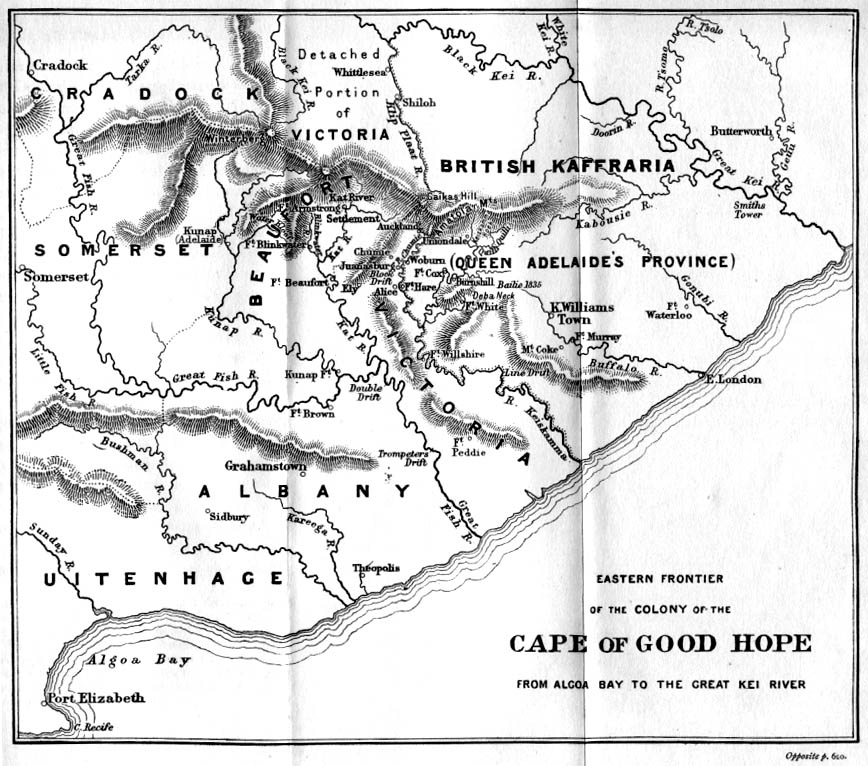
Butterworth was first established as a Wesleyan mission station in 1827 north of the Great Kei River in British Kaffraria.[5] It was named after Joseph Butterworth.[6] The mission station and white settlement of Butterworth was burnt down 3 times during the Cape Frontier Wars.[3] Nonetheless, it is one of the oldest white settlements in Eastern Cape. When the British seized the Cape of Good Hope, many of the Boers trekked north to establish their own republics. The discovery of diamonds (1867) and gold (1886) in South Africa spurred wealth and immigration and intensified the subjugation of the native inhabitants. The town was close to the seat of Hintsa ka Khawuta, the King of the Xhosa people. It was of great strategic importance.
Around that time, a young girl, Nongqawuse, had a vision that her forebears would help the Xhosa drive the English out. The disastrous result weakened the Xhosa. The Ninth Frontier War spelled the end of the Xhosa, and the Transkei area was incorporated into the Cape Colony. But it was never quiet. There were raids between settlers and Xhosa, and turf wars between different Xhosa groups. Missions were established here and there to try to bring Christianity to the local people, with limited success.[7]
Butterworth is the birthplace of Marmaduke Pattle, the highest scoring RAF ace of World War 2, and Bill Drummond, a Scottish artist, musician, writer, and record producer.
At the end of the Frontier Wars in 1878, traders began to settle here and the town has grown to become a small industrial centre. Butterworth became a municipality of the Cape Colony in 1904.[6] The town was incorporated into the former Transkei bantustan during the apartheid years. It is one of the fastest-growing towns in terms of the economy and the population.[8]
Currently Butterworth is home to nine townships.
Demographics
[edit]The town is predominantly Black and Xhosa-speaking. According to the 2001 South African census, the "main place" of Butterworth had a population of 45,900. Of these, 45,142 (98.4%) were recorded as "Black", 345 (0.8%) as "Coloured", 213 (0.5%) as "Indian or Asian" and 200 (0.4%) as White. The most common language spoken at home was Xhosa (96.9%), followed by English (1.7%) and Afrikaans (0.5%). The town is 57% female and 43% male.
Religion
[edit].jpg)
The supreme being among the Xhosa is called uThixo. Christianity in one form or another is accepted by most people today. Cultural traditionalists are likely to belong to independent denominations that combine Christianity with traditional beliefs and practices.
The Church of the Province of Southern Africa has played an important role in the life of the Butterworth community. The late Archbishop Desmond Tutu was seen as a significant spiritual leader. St Peter's Church is a beautiful example of 19th Century colonial architecture.[2][3][4]
Economy
[edit]Butterworth is the main service area for Mnquma municipality, contributing 77% of the GDP in the municipality and is an important town in the new South Africa. It now has several major industrial sites, including Zitulele and Ibeka, on its outskirts. Its industries produce processed food, beverages, tobacco products, beer, textiles, clothing, leather goods, wood and wood products, chemicals, rubber and plastic products. It is on the Mthatha-East London railway line, but rarely sees a passenger train. This may change when the Bhisho government gets a main line passenger rail service operational.
Butterworth's town area is relatively small, including a small business district of middle-to-high income housing. The central town, established exclusively “white” before 1976, has since been occupied largely by black high-income groups. White occupancy has not been re-established post-1994. Development in Butterworth has followed the line of the N2 and thus resulted in a long, narrow settlement east of town towards Walter Sisulu University (WSU), about 5 km away. The N2 also runs through the CBD, which results in a clash of uses and congestion, with high speed road transport seeming to use the same space as pedestrians, hawkers and public service functions.[10] [11]
Butterworth is also home to the first shopping centre in the area. October 24 and 25 2012 saw the much-awaited launch of the Fingoland Mall [12] development in the small town of Butterworth. Fingoland Mall extends over 12,700 m2, which is less than half of the total footprint of the shopping centre when complete after the third and last phase is built. As of December 2014, there were 51 tenants, which includes but is not limited to major national retailers, as well as accommodating no less than 10 micro-businesses. On completion of the third phase, Fingoland Mall is expecting a minimum total of 100 shops. The development has already created approximately 350 jobs, and by the end of the third phase, the total number of jobs created is expected to reach 1000.[needs update]
Tourism
[edit]Tourist attractions include Bawa Falls, Birding, Cape Vulture Colony, Collywobbles on Mbashe River, Gcuwa River Cascades and various historical sights. Butterworth is surrounded by beautiful countryside. Visitors can go for day walks to the nearby villages such as Tobashana and experience the hospitality of traditional Xhosa living. Gcuwa Dam provides for a man-made lake for boating and fishing.
Nearby Bawa Falls on the Qolorha River, has a sheer drop of nearly 300 ft. The dirt road leading to the falls is just west of the town. Winding through the Transkei countryside, little has changed in the past 100 years. The district's scenery is attractive with its almost ever-green thorn trees and tropical flowers. Bawa Falls has a popular picnic spot and more adventurous hikers can camp overnight. The Cascades Falls on the Gcuwa (Butterworth) River has a reputed fall of 270 ft. Butterworth is the starting point for a number of nature walks.
Hospitals
[edit]Butterworth has two provincial hospitals: Butterworth Hospital in the central town is the main hospital serving the people of Dutywa, Willowvale, Centane and Butterworth; and Tafalofefe Hospital in the rural district about 15 km east of Butterworth.[13]
References
[edit]- ^ a b c d "Main Place Butterworth". Census 2011.
- ^ a b Random House Compact World Atlas. Random House. 2006. p. 59. ISBN 0-375-72189-4.
- ^ a b c Butterworth, Travelblog p.1 - 2
- ^ a b Tony Pinchuck, Barbara McCrea & Donald Reid, Rough guide to South Africa, Lesotho & Swaziland, Edition 3, Rough Guides, 2002. p. 425
- ^ British Kaffraria, map.
- ^ a b Erasmus, B. P. J. (1995). On Route in South Africa. Internet Archive. Johannesburg: Jonathan Ball Publishers. p. 205. ISBN 978-1-86842-026-1.
- ^ Jeffrey B. Peires, The dead will arise, Indiana University Press, 1989. pp 141 -159
- ^ Hazel Crampton, The Sunburnt Queen, Jacana Media, 2004. pp 60 - 63
- ^ "Wesleyan Mission-Premises, Butterworth, Kaffraria, Southern Africa". Wesleyan Juvenile Offering. VIII. London: Wesleyan Mission-House: 65. June 1851. Retrieved 30 November 2015.
- ^ Butterworth, Encyclopædia Britannica p.1
- ^ Butterworth, Aspire 2008 Archived 2010-12-06 at the Wayback Machine p 1
- ^ Fingoland Mall Website
- ^ Eastern Cape Dept of Health Archived 2012-04-29 at the Wayback Machine
Municipalities and communities of Amathole District Municipality, Eastern Cape | ||
|---|---|---|
District seat: East London | ||
| Amahlathi | .svg) | |
| Great Kei |
| |
| Mbhashe |
| |
| Mnquma |
| |
| Ngqushwa | ||
| Raymond Mhlaba |
| |
| Geographic | |
|---|---|
| Other | |
Butterworth, South Africa
View on GrokipediaHistory
Founding and Early Settlement
Butterworth originated as a Wesleyan Methodist mission station established in 1827 among the Gcaleka Xhosa people under Chief Hintsa in the Transkei region, north of the Great Kei River.[2] The site was selected for its arable land, water sources, and timber resources, following negotiations with local leaders including Ndlambe.[5] William Shrewsbury, a Wesleyan missionary, founded the station that year after initial resistance from Hintsa, who relocated his people temporarily before granting permission.[5] The settlement was named after Joseph Butterworth, treasurer of the Wesleyan Missionary Society.[6] Early efforts involved key missionaries such as William Shaw, who facilitated negotiations, and Stephen Kay, who supported initial operations alongside lay assistants like Richard Tainton in construction.[5] The mission attracted Mfengu refugees, with 5,000 to 6,000 settling nearby by late 1827, drawn by offers of refuge, land allocation, and irrigation systems; these groups adopted European-style cottages and participated in services and schools.[5] Over the first eight years, 35 baptisms occurred, though overall conversions remained limited, with only 22 society members recorded by 1834 amid Xhosa skepticism toward Christian teachings on divinity and morality.[5] The station faced severe challenges from regional conflicts, including Xhosa resistance to missionary presence and colonial expansion.[2] During the Sixth Frontier War (1834–1835), Hintsa's forces destroyed the mission, confiscating goods and burning structures, forcing missionary John Ayliff to evacuate to Clarkebury in February 1835.[5] Despite such setbacks, the missionaries rebuilt the station multiple times, leveraging Mfengu alliances for intelligence and labor, which aided colonial interests.[2] This resilience laid the foundation for gradual white settlement in an area previously dominated by Xhosa chiefdoms.[6]Industrial Growth and Transkei Era
During the apartheid era, Butterworth was designated as a key "growth point" within the Transkei bantustan as part of South Africa's Industrial Decentralisation Policy, initiated in 1956 and revised in 1982 to promote manufacturing in border areas adjacent to white-designated regions.[7] This strategy aimed to relocate labor-intensive industries to homelands like Transkei, which achieved self-governing status in 1963 and nominal independence in 1976, thereby supporting the government's separate development doctrine by creating employment opportunities for black workers while limiting urban migration.[7] Incentives included tax holidays, cash grants covering up to 80% of the wage bill for the first two years, 60% transport rebates, training allowances of R110 per worker per month, and subsidies for housing and infrastructure, administered through mechanisms like the Transkei Development Corporation (TDC), which provided factory shells and utilities.[7] In 1971, Butterworth was formally declared an Industrial Development Point, spurring initial investments, with a significant surge occurring after 1983 under the updated incentive scheme.[7] By 1989, the town hosted 115 manufacturing firms across 51 large-scale operations, peaking during what has been termed the "Golden Decade" of industrial expansion, driven by low-wage labor (often without union representation until the early 1990s) and proximity to the East London port for exports and imports.[7] Dominant sectors included textiles and clothing (e.g., Tramatex), food and beverages (e.g., South African Breweries and Premier Milling), metals, and chemicals, attracting firms such as Taiwanese textile operations seeking cost advantages.[7] Manufacturing employment reached 6,849 workers in 1985, comprising 56% of the town's total formal jobs, with the TDC facilitating infrastructure like water, electricity, and industrial sites at Zitulele and Ibeka on the outskirts.[7] The Transkei government under leaders like Chief George Matanzima reinforced this growth through a 1987 Master Plan, which prioritized industrial zoning and housing to accommodate workers, though rapid expansion led to acute shortages of rental properties, all controlled by state entities.[7] Initial success stemmed from the policy's financial allure—subsidies effectively halved labor costs for relocating firms—and Transkei's political stability relative to urban South Africa, enabling full occupancy of factories by the late 1980s.[7] However, the model relied on external South African capital and minimal local linkages, with industries exhibiting slow growth and limited skill transfer, reflecting the bantustan's structural dependence rather than endogenous economic vitality.[7] Labor unrest emerged around 1989 amid rising demands for rights, foreshadowing vulnerabilities as national political transitions loomed.[7]Post-Apartheid Transition and Decline
Following the reintegration of the former Transkei homeland into [South Africa](/page/South Africa) in 1994, Butterworth experienced a rapid shift from its status as an apartheid-era industrial growth point, where government incentives had attracted manufacturing firms through decentralization policies. These incentives, including subsidies and infrastructure support, were discontinued post-apartheid, leading to the closure of key factories and a sharp contraction in industrial activity. By the early 2000s, the local economy had atrophied, with thousands of jobs lost as enterprises relocated to more viable areas outside the former homelands.[8][9] Unemployment rates in Butterworth surged amid this deindustrialization, exacerbating poverty in a town already reliant on low-skill manufacturing. Provincial unemployment in the Eastern Cape stood at approximately 41% by 1995, with Butterworth's figures remaining structurally high into the 2020s, driven by limited new investment and skills mismatches. Recent surveys indicate that structural unemployment predominates, with youth and semi-skilled workers hardest hit, contributing to household poverty levels exceeding 50% in surrounding districts like Amathole. The restructuring of the Transkei bureaucracy post-1994 further displaced civil service jobs, compounding private-sector losses without commensurate job creation elsewhere.[7][10][11] Service delivery failures became emblematic of the decline, with residents protesting inadequate water supply, road maintenance, and electricity amid deteriorating infrastructure inherited from the Transkei era. Notable unrest included blockades of the N2 highway in 2024 over access grievances, school and business shutdowns in 2023, and repeated water-related demonstrations in 2019 and 2020, often met with threats and limited municipal response. These protests reflect broader governance challenges, including fiscal mismanagement and delayed capital projects, which have hindered recovery despite national development frameworks.[12][13][14][15]Geography and Environment
Location and Topography
Butterworth is a town in the Mnquma Local Municipality within the Amathole District Municipality of the Eastern Cape province, South Africa.[16] It is positioned at geographic coordinates approximately 32°20′S latitude and 28°09′E longitude.[17] The town lies inland, roughly 80–100 kilometers northeast of the port city of East London, in the historical Transkei region.[18] [19] The topography of Butterworth features moderate elevation, with the town center at 545 meters above sea level.[17] The surrounding vicinity exhibits an average elevation of 599 meters, characterized by undulating terrain as depicted in regional topographic mappings.[16] This landscape includes rolling hills and valleys, influenced by the broader Eastern Cape's east-west trending ranges and riverine features, such as proximity to the Great Kei River system.[20]Climate Patterns
Butterworth features a temperate climate characterized by warm, wet summers and short, cooler, drier winters, with precipitation concentrated in the warmer months due to convective thunderstorms influenced by the Indian Ocean.[21] Average annual temperatures range from daytime highs of approximately 23.3°C to nighttime lows of 11.3°C, yielding a mean of about 17.3°C.[22] Temperatures typically vary between 6°C and 26°C annually, rarely dropping below 2°C or exceeding 31°C.[21] Summer, spanning December to February, brings average highs of 25°C and lows around 15°C, accompanied by high humidity and frequent rainfall from afternoon thunderstorms.[23] Monthly precipitation peaks during this period, contributing the majority of the site's annual total of roughly 891 mm.[24] Winters from June to August are milder, with highs near 18–20°C and lows dipping to 5–7°C, often accompanied by windy conditions but minimal rain, as frontal systems from the south bring occasional clear skies rather than significant moisture.[21] [23] Precipitation exhibits strong seasonality, with summer months averaging 100–150 mm and winter months under 50 mm, reflecting a pattern of summer-dominant rainfall typical of the region's subtropical influences moderated by elevation and distance from the coast.[25] Annual totals can vary, occasionally leading to localized flooding during intense summer events or water stress in prolonged dry winters, though long-term data indicate relative stability without pronounced multi-decadal shifts.[24] Wind patterns shift from easterly sea breezes in summer to stronger westerlies in winter, enhancing the perception of chill during cooler periods.[21]Demographics
Population Dynamics
The population of Butterworth experienced rapid growth during the mid-20th century, driven by its role as an administrative center in the Transkei bantustan and industrial decentralization policies that attracted rural migrants seeking employment. Historical records indicate a population of 281 in 1891, rising to 2,769 by 1970, approximately 33,370 in 1990, and around 60,000 in 1997, with annual growth rates of 22.9% from 1970 to 1980, 5.19% from 1980 to 1985, and 8.6% from 1990 to 1997.[7] This expansion was fueled by influx from surrounding rural areas, leading to the proliferation of informal settlements and informal trade in the central business district.[7] In the municipal context, Butterworth serves as the primary urban node within Mnquma Local Municipality, where the overall population peaked at 252,390 in the 2011 census before declining to 232,993 by the 2022 census, reflecting an annual decrease of 0.51%.[26] The town's urban area specifically recorded 44,308 residents in 2011, down from an estimated 45,903 in 2001, indicating stagnation or contraction amid broader provincial growth in the Eastern Cape (10.2% increase from 2011 to 2022).[4] [27] [28] Key dynamics include persistent rural-to-urban migration into Butterworth, contributing to a high youth dependency ratio (over 44% under age 15 in the 1990s) and a skewed sex ratio favoring women, as male laborers often migrate further to industrial hubs like Gauteng for work.[7] Post-apartheid deindustrialization, marked by factory closures and structural unemployment, has reversed earlier trends, prompting out-migration and population contraction despite limited inflows from other provinces.[7] These shifts align with limited inter-provincial mobility into the Eastern Cape, exacerbating local demographic imbalances.[7]Ethnic and Linguistic Makeup
The ethnic composition of Butterworth reflects the broader demographics of the Eastern Cape's Xhosa heartland, with Black Africans forming the vast majority. In the 2011 census, the main place of Butterworth recorded a population of 44,039, of which 98% identified as Black African, 1% as Coloured, and 1% as White, with Indian/Asian residents comprising less than 0.1%.[29] This distribution aligns with Mnquma Local Municipality's overall profile, where Black Africans account for 99.4% of the 2011 population of approximately 180,000, underscoring minimal diversity from other groups historically concentrated in urban or Western Cape areas.[30] Linguistically, isiXhosa dominates as the first home language, spoken by 93% of Butterworth residents in 2011, serving as the primary medium of daily communication and cultural transmission among the Black African majority.[29] English, used in official and educational contexts, is the second most common at around 4%, while Afrikaans and isiZulu each represent under 1%, with other languages negligible.[4] Ward-level data from Mnquma confirms this pattern, with isiXhosa exceeding 96% in areas encompassing Butterworth, reflecting linguistic stability tied to ethnic homogeneity rather than recent migration shifts.[31] No significant changes are evident in post-2011 community surveys at the municipal level, though national trends show slight urbanization potentially introducing minor multilingualism.[28]Religious Composition
The religious composition of Butterworth aligns closely with provincial trends in the Eastern Cape, characterized by a strong Christian majority. According to Statistics South Africa's 2022 Census, 86.1% of the Eastern Cape population adheres to Christianity, encompassing various denominations including Protestant, Catholic, and independent churches.[32] Traditional African religions represent 11.0% of the provincial population, often practiced alongside Christian beliefs in syncretic forms among Xhosa communities.[32] Smaller religious groups include Muslims at 0.6%, Hindus at 0.1%, and those with no religious affiliation at 1.3%.[32] Butterworth's establishment as a Wesleyan Methodist mission station in the early 19th century has contributed to a historical emphasis on Protestant Christianity, particularly Methodism, within the town and surrounding areas.[33] Detailed municipal-level data for Mnquma Local Municipality, which encompasses Butterworth, remains unavailable in official releases, but the town's demographics suggest proportions similar to the provincial average given its predominantly Xhosa population.[32]Local Governance
Municipal Administration
Mnquma Local Municipality serves as the primary local government entity administering Butterworth and its surrounding rural areas, functioning as a Category B municipality within the Amathole District Municipality of the Eastern Cape Province.[34] Established under the Local Government: Municipal Structures Act of 1998, it encompasses approximately 2,277 square kilometers and operates from its headquarters in Butterworth at the corner of King and Mthatha Streets, with postal address PO Box 36, Butterworth, 4960.[35] The municipality's administration focuses on delivering core services including water supply, sanitation, electricity distribution, waste management, and road maintenance, while pursuing developmental objectives aligned with national and provincial frameworks.[1] The municipal council comprises 45 elected members, with the African National Congress holding a majority control as of the most recent local government elections.[36] Leadership includes Executive Mayor Tunyiswa Manxila-Nkamisa, Speaker Monica Qaba, and Municipal Manager Silumko Mahlasela, who oversees executive functions and operational implementation.[36] The structure adheres to a committee system under Sections 79 (portfolio committees for oversight) and 80(1) (executive committee for decision-making) of the Municipal Structures Act, covering areas such as finance, planning, community services, and infrastructure. Administratively, the municipality is organized into key directorates—Corporate Services, Community Services, Technical Services, and Planning and Development—to facilitate service delivery and strategic planning.[1] In the 2023/2024 financial year, efforts included reviewing and implementing an updated organizational structure, filling critical vacancies, and aligning resources with the Integrated Development Plan (IDP) to address local priorities like infrastructure upgrades and economic facilitation.[37][38] Contact for public inquiries is handled via phone at 047 401 2400 or email at [email protected], supporting transparency in governance.[1]Political and Electoral Context
The Mnquma Local Municipality, which administers Butterworth as its administrative seat, operates under an executive mayoral system where the African National Congress (ANC) has held uninterrupted control since the post-apartheid local elections began in 1995-1996. In the November 1, 2021, municipal elections, the ANC secured 45 of the 63 council seats through a combination of ward and proportional representation voting, reflecting its entrenched support among the predominantly Xhosa-speaking electorate tied to the party's historical role in anti-apartheid resistance.[36] Opposition parties, including the Democratic Alliance (DA) and smaller groups like the Economic Freedom Fighters (EFF), hold limited representation, with the DA typically garnering under 10% of votes in rural Eastern Cape wards due to weaker organizational presence and focus on urban issues.[36] The current executive mayor, Cllr. Tunyiswa Manxila-Nkamisa (ANC), leads the mayoral committee, supported by a council speaker (Cllr. Monica Qaba, ANC) and chief whip (Cllr. Sithembiso Ncetezo, ANC), emphasizing priorities like infrastructure maintenance and poverty alleviation aligned with national ANC policy.[39] [35] Voter turnout in Mnquma's wards has averaged around 50-60% in recent cycles, influenced by disillusionment over persistent service delivery shortfalls, such as unmaintained roads and water supply interruptions, which have sparked localized protests and reduced enthusiasm for ANC candidates despite their dominance.[40] Electoral dynamics in Butterworth highlight broader Eastern Cape patterns, where ANC majorities exceed 70% in many rural municipalities, sustained by patronage networks and limited viable alternatives, though independent candidates and emerging parties have occasionally challenged wards amid corruption allegations against councilors.[36] By-elections since 2021, such as those in nearby Amathole District wards, show ANC retention of seats but narrowing margins in response to public grievances over municipal mismanagement, signaling potential shifts ahead of the 2026 polls.[41]Economy
Historical Economic Foundations
Butterworth originated as a Wesleyan Methodist mission station in 1827, the first such establishment in the Transkei region, initially consisting of a church and missionary residences amid Xhosa territories north of the Great Kei River.[3] The mission introduced European agricultural practices, including private land ownership, individual plot cultivation, ploughed fields, orchards, and vegetable gardens, contrasting with traditional Xhosa communal subsistence farming and cattle herding centered on livestock as wealth and status symbols.[5] These efforts aimed to foster self-sufficiency through surplus production, with station residents required to cultivate land or face exclusion, while attracting marginalized groups like the poor and Mfengu refugees through access to irrigation and tools.[5] Crafts such as thatching, plastering, and wagon-driving were taught by mechanic missionaries, supplementing agriculture and preparing residents for wage labor.[5] Missionaries facilitated trade by mediating between Xhosa communities and colonial authorities, supporting fairs like Fort Willshire where locals exchanged goods at fair prices, and operating station stores for basic needs.[5] However, these interventions disrupted traditional economic structures, including bridewealth and communal resource use, prompting resistance from chiefs like Hintsa, who confiscated cattle and discouraged participation to preserve Xhosa autonomy.[5] By the late 19th century, the town evolved into a commercial hub with shops and services, bolstered by its role as a British military headquarters during the Frontier Wars of the 1870s-1880s, leading to infrastructure like the 1897 Town Hall and 1904 municipal council.[3] In the mid-20th century, under apartheid's separate development policy, Butterworth was designated a growth point in the Transkei bantustan, with industrial decentralization incentives from the 1960s attracting manufacturing firms through tax rebates, subsidies (e.g., R110 per worker monthly), and infrastructure investments.[3] This established labor-intensive sectors like textiles, clothing, food processing, and beverages, peaking at 115 firms in 1989 and contributing R95.8 million to gross geographic product in 1980, though reliant on imported materials and external ownership (e.g., 61.7% South African, 15% Taiwanese in 1990).[3] Agriculture remained marginal, comprising just 2.4% of output by 1991 despite fertile potential, underscoring the shift to import-dependent industry as the economic foundation.[3]Current Sectors and Employment
The economy of Mnquma Local Municipality, where Butterworth serves as the primary urban and administrative center, is predominantly tertiary-oriented, with community services contributing 42.0% to gross value added (GVA) and employing 13,900 people (38.4% of total formal and informal jobs) in 2023.[42] Trade, encompassing wholesale and retail, accounts for 19.9% of GVA (R2.3 billion) and 8,820 jobs (24.3%), while the finance sector represents 19.5% of GVA (R2.2 billion) and 4,070 jobs (11.2%).[42] Secondary sectors like construction provide 2,770 jobs (7.7%), but manufacturing has significantly declined since the late 1990s, with limited current contributions amid low skills levels and industrial atrophy.[42] Primary sectors remain marginal, with mining employing only 23 people (0.1%) despite resources like granite and titanium, and agriculture focused on livestock (811,461 cattle as of recent counts) and crops on 332,335 hectares, though without dominant GVA share.[42]| Sector | GVA Share (2023) | GVA (R billion) | Employment (2023) | Employment Share |
|---|---|---|---|---|
| Community Services | 42.0% | 4.79 | 13,900 | 38.4% |
| Trade | 19.9% | 2.3 | 8,820 | 24.3% |
| Finance | 19.5% | 2.2 | 4,070 | 11.2% |
| Construction | Not specified | Not specified | 2,770 | 7.7% |
| Mining | Not specified | Not specified | 23 | 0.1% |
Unemployment and Structural Challenges
Unemployment in Butterworth, located within the Mnquma Local Municipality of the Eastern Cape, significantly exceeds the national average, reflecting broader provincial trends where rates surpass 40% compared to South Africa's 33.2% official rate in the second quarter of 2025. Local studies indicate persistent long-term joblessness, with 44.7% of surveyed unemployed residents out of work for over three years, disproportionately affecting youth and women (56.5% of respondents female). Mnquma's municipal reports consistently highlight unemployment as a core challenge, intertwined with high poverty and limited formal job opportunities, exacerbating reliance on social grants amid structural poverty in the region.[43][44][37] Structural unemployment dominates, with a prevalence score of 3.15 on assessment scales, stemming from skills mismatches—particularly deficiencies in ICT, engineering, and other high-demand fields—and limited economic diversification beyond declining sectors. Butterworth's historical role as an apartheid-era growth point, featuring a manufacturing boom (56% of employment in 1985), collapsed post-1994 due to withdrawn incentives, labor unrest, and policy shifts, resulting in factory closures (e.g., 20 since 1990) and over 5,000 job losses by the late 1990s. This deindustrialization persists, with manufacturing now supporting only around 2,000 jobs amid vacant facilities, while the informal sector expands (e.g., street trading overtaking central business districts) but fails to generate sustainable employment.[44][3] Compounding factors include cyclical downturns (e.g., post-COVID effects), frictional barriers from poor labor market information, and infrastructural deficits like decaying rural networks that hinder investment and mobility. Weak local governance, including municipal financial distress (e.g., salaries consuming 80% of budgets in the 1990s, with ongoing debt), low skills bases, and competition from better-equipped areas perpetuate these issues, fostering dependency on grants and informal survival strategies rather than productive economic integration. Youth unemployment in the Eastern Cape reached 54.3% in early 2025, underscoring the urgency of targeted training and diversification to address these entrenched barriers.[44][3][45]Education
School System and Enrollment
The school system in Butterworth operates within South Africa's national basic education framework, administered by the Eastern Cape Department of Education, which mandates compulsory attendance from ages 7 to 15 (grades 1-9), with voluntary progression to grades 10-12 for senior secondary certification. Public schools, funded primarily through provincial allocations and categorized by quintiles based on poverty levels (quintiles 1-3 being no-fee institutions), form the backbone, supplemented by a small number of independent schools. In Mnquma Local Municipality, encompassing Butterworth, the system emphasizes foundational literacy and numeracy in early grades amid broader challenges like rural access and resource constraints.[42] As of 2023, Mnquma reported 723 schools serving the area, predominantly public ordinary institutions tailored to developmental stages:| School Type | Number |
|---|---|
| Public Ordinary (Total) | 698 |
| Grades R-7 (Primary) | 534 |
| Grades R-9 (Intermediate) | 101 |
| Grades 8-12 (Secondary) | 87 |
| Learners with Special Needs | 1 |
| Independent Schools | 25 |