
Community hub
Recent from talks
Contribute something
Nothing was collected or created yet.
Ja-Ela
View on WikipediaThis article includes a list of general references, but it lacks sufficient corresponding inline citations. (March 2016) |
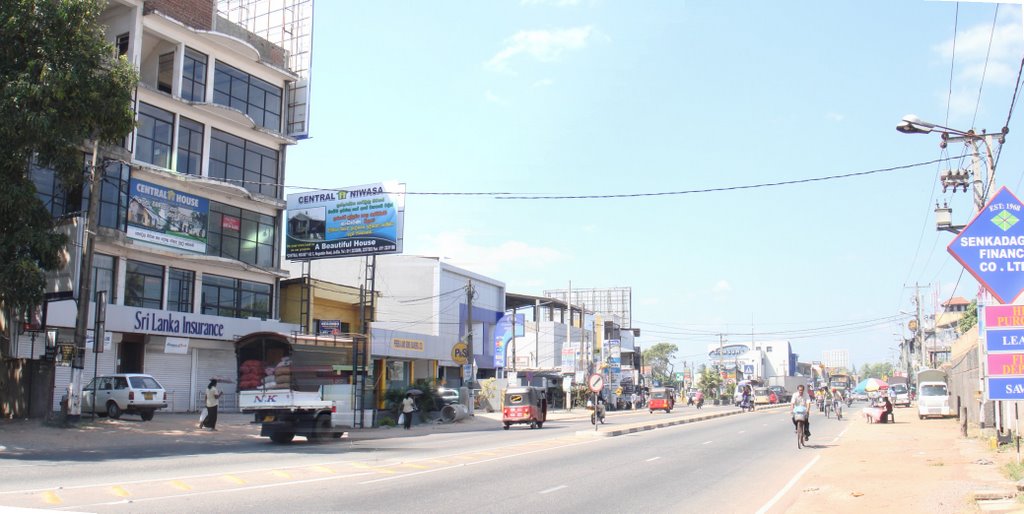
Ja-Ela (Sinhala: ජා-ඇල, Tamil: ஜா-எல) is a town, located approximately 20 km (12 mi) north of the city centre of Colombo, Sri Lanka. Ja-Ela lies on the A3 road which overlaps with the Colombo – Katunayake Expressway at the Ja-Ela Interchange.
Key Information


Etymology
[edit]The etymology of the name is uncertain, and there are several yet arguable interpretations of the name. Howbeit, based on verified historical shreds of evidence, the etymology of the place, Ja Ela is based on both Malay and Sinhala languages. "Ja" and "Javan" are referential terms used by the Sinhalese, Moors & Tamils to address the Malays/Javanese or those of Indonesian descent and the term "Ela" is derived from Sinhala language meaning stream, lake or canal.[1]
Local government council
[edit]Ja-Ela is administered by the Ja-Ela Urban Council.
Populations
[edit]32,175
Demographics
[edit]Majority of the people from Ja-Ela are generally Sinhalese, along with other minority communities such as Tamils, Muslims and Burghers.
The following table summarises the population of Ja-Ela DS Area which covers both urban sectors and rural sectors, according to ethnicity (2012 Census)
| Ethnicity | Population | % of Total |
|---|---|---|
| Sinhalese | 186,086 | 92.34% |
| Sri Lankan Moors | 853 | 0.423% |
| Sri Lankan Tamils | 8,042 | 4% |
| Indian Tamils | 1,236 | 0.613% |
| Burghers | 3,453 | 1.71% |
| Bharatha | 45 | 0.02% |
| Sri Lankan Malays | 1,239 | 0.614% |
| Sri Lankan Chetty | 120 | 0.06% |
| Others | 447 | 0.22% |
| Total | 201,521 | 100% |
Source: Department of Census and Statistics, 2012[2]
Majority of residents belong to the Christian denomination, followed by a large proportion of Buddhists.
Religious composition in Ja-ela DS Division according to 2012 census are as follows Roman Catholics 99,515-49.38%, Buddhists 87,772-43.55%, Other Christians 7,746-3.84%, Hindus 4,235-2.10%, Muslims 2,115-1.05%, Others 138-0.07%.
Transport
[edit]This suburb is situated on the main road A3, between Colombo municipality and Negombo municipality. Ja-Ela is situated very close to the Bandaranaike International Airport. There is also a bus stand in Ja-Ela which provides access to Colombo, Negombo, Gampaha. The traffic issues at Ja-Ela have been reduced after the introduction of the Colombo – Katunayake Expressway, which serves an interchange at Ja-Ela.
Railway
[edit]The Ja-Ela railway station is located on the Puttalam line and was opened in 1908. It is the fourth station on the line and is 22.15 km (13.76 mi) from Colombo Fort railway station. The station provides commuter access to the Colombo, Putlam and Chilaw areas. Not only is the station in the heart of the Ja- Ela town, it is also the nearest station to the Negombo-Colombo Main road. Therefore, it is known as one of the most popular stations in the area.
Schools
[edit]- Christ King College, Tudella
- Mary Immaculate Convent, Tudella
- St. Maries College, Ja-Ela
- Jayanthi Vidyalaya, Ja-Ela
- King's International College - Kapuwatta[3]
Geography
[edit]Climate
[edit]| Climate data for Ja-Ela, Sri Lanka | |||||||||||||
|---|---|---|---|---|---|---|---|---|---|---|---|---|---|
| Month | Jan | Feb | Mar | Apr | May | Jun | Jul | Aug | Sep | Oct | Nov | Dec | Year |
| Mean daily maximum °C (°F) | 30 (86) |
31 (88) |
33 (91) |
34 (93) |
34 (93) |
32 (90) |
32 (90) |
32 (90) |
32 (90) |
31 (88) |
30 (86) |
29 (84) |
32 (90) |
| Mean daily minimum °C (°F) | 22 (72) |
22 (72) |
24 (75) |
26 (79) |
26 (79) |
25 (77) |
24 (75) |
24 (75) |
24 (75) |
24 (75) |
23 (73) |
22 (72) |
24 (75) |
| Average precipitation mm (inches) | 16 (0.6) |
19 (0.7) |
22 (0.9) |
63 (2.5) |
54 (2.1) |
87 (3.4) |
130 (5.1) |
140 (5.5) |
111 (4.4) |
192 (7.6) |
141 (5.6) |
71 (2.8) |
1,046 (41.2) |
| Average precipitation days | 1 | 1 | 2 | 3 | 3 | 2 | 3 | 4 | 5 | 8 | 7 | 4 | 43 |
| Source: World Climate Guide. To check the current Weather - Visit: https://www.worldweatheronline.com/ja-ela-weather/western/lk.aspx | |||||||||||||
References
[edit]- ^ Careem, Tuan M. Zameer.(2017). Persaudaraan (Brotherhood). Malay Life in Sri Lanka (2nd ed). Colombo: S Godage & Brothers. Print
- ^ "Population by divisional secretariat division, sex and sector" (PDF). statistics.gov.lk. Department of Census and Statistics. Retrieved 29 June 2022.
- ^ "King's International College". King's International. King's Care. Retrieved 16 February 2019.
| National capitals# |
| |
|---|---|---|
| Municipal councils | ||
| Urban councils |
| |
Note: * also a Provincial capital, # also a Municipal council | ||
This Western Province, Sri Lanka location article is a stub. You can help Wikipedia by expanding it. |
Ja-Ela
View on GrokipediaHistory
Etymology
The name Ja-Ela derives from Sinhalese linguistic elements, with "ja" (or "java") denoting Malay or Javanese people and "ela" signifying a brook, rivulet, channel, or canal.[5] This etymology reflects the historical settlement of approximately 40,000 Sri Lankan Malays, many of whom arrived during the 17th and 18th centuries under Dutch colonial rule from Southeast Asia, including Java, and contributed to local infrastructure such as canals for water management in paddy fields.[5] The term "Ja-Ela" thus originally referred to a canal associated with these Javanese or Malay communities, a feature that persists in the area's geography and gave rise to the town's name at the junction of the canal and the Colombo-Negombo road during the Dutch period.Early Settlement and Development
Ja-Ela's origins as a settlement date to the Dutch colonial period (1658–1796), when the town formed at Gala Junction, the intersection of the Ja-Ela canal and the Colombo-Negombo main road. This location emerged due to the canal's construction in the 18th century, primarily for irrigation of paddy fields and facilitating inland transportation between coastal areas.[6][7] The name Ja-Ela derives from Sinhalese terms where "ja" denotes Javanese or Malay people and "ela" means canal or stream, reflecting the presence of Malay soldiers and their descendants settled by the Dutch East India Company in the 17th and 18th centuries. These communities, brought from Southeast Asia to serve in colonial forces, contributed to early demographic diversity alongside indigenous Sinhalese agrarian populations in the fertile wet zone lowlands. Initial development centered on basic trade, farming, and transit activities, with the canal-road nexus enabling movement of goods like rice and coconuts toward Colombo and Negombo.[8][5]Modern Growth and Urbanization
The population of the Ja-Ela Divisional Secretariat grew from 184,666 in the 2001 census to 201,521 in 2012, yielding an annual growth rate of 0.82 percent over the period, driven by suburban expansion from Colombo and employment opportunities in nearby industrial zones.[4] [9] This trend reflects broader urbanization in the Gampaha District, where improved transport links have attracted commuters and migrants, increasing residential density to 3,359 persons per square kilometer by 2012 across the secretariat's 60 square kilometers.[4] Key infrastructure developments, including the Ja-Ela interchange on the Colombo-Katunayake Expressway (E03), completed in stages through 2013, have accelerated growth by reducing travel times to Colombo and the Bandaranaike International Airport, spurring commercial and real estate activity.[10] [11] Additional enhancements, such as a new traffic lane at the interchange approved in recent years, address rising congestion from heightened vehicle volumes.[11] The area's integration into the Western Region Megapolis Master Plan further promotes coordinated urban expansion, emphasizing efficient land use along linear corridors toward Negombo and Gampaha.[12] Urbanization manifests in a surge of residential projects, including VIMAN Ja-Ela, a 6-acre development by John Keells Properties featuring 418 apartments across multiple phases, with Phase 3 launched by 2025 and generating over LKR 4.2 billion in sales by late 2024 due to demand for proximity to expressway access and urban amenities.[13] [14] [15] Comparable initiatives, such as Central Park Ja-Ela spanning 15 acres with over 40 amenities, underscore the shift toward high-density housing supported by new shopping complexes, schools, and healthcare facilities.[16] [17] Industrial activity in adjacent Ekala zones, bolstered by highway proximity, complements this by fostering small and medium enterprises, mirroring expressway-induced economic effects observed nationally, including SME proliferation and unemployment reductions.[18] [19] Public infrastructure like the Gampaha-Ja-Ela bus stand redevelopment enhances local mobility amid these changes.[20]Geography
Location and Physical Features
Ja-Ela is situated in the Gampaha District of Sri Lanka's Western Province, approximately 20 kilometers north of Colombo's city center, along the A3 highway linking Colombo to Negombo.[21] The town's geographic coordinates are roughly 7°04′N 79°54′E.[22] The physical landscape consists of flat, low-lying terrain characteristic of the southwestern coastal plain, with elevations averaging 9 meters above sea level and rarely exceeding 13 meters.[23] [24] This topography results from alluvial deposits in a tropical lowland environment, making the area susceptible to seasonal flooding.[25] A notable physical feature is the Ja-Ela canal, which runs through the town center and maintains an average width greater than 25 meters, serving as a key waterway in the region's hydrology.[7] The surrounding area features urbanizing suburbs with minimal topographic variation, supporting dense settlement and infrastructure development.[26]Climate
Ja-Ela experiences a tropical monsoon climate (Köppen classification Am), typical of Sri Lanka's wet zone, marked by consistently high temperatures, elevated humidity levels averaging 75-85%, and abundant rainfall distributed across two primary wet seasons influenced by the southwest and northeast monsoons.[27] The southwest monsoon, from May to September, delivers heavy precipitation to the western coastal region, while the second inter-monsoonal period in October and November contributes additional intense rainfall, resulting in no true dry season but relative lulls from December to April.[27] Annual precipitation totals approximately 2,505 mm, with the wettest months being October (352 mm) and November (around 216 mm), and the driest being January and February (under 100 mm each). Temperatures remain warm year-round, with average highs ranging from 30°C to 32°C and lows from 24°C to 26°C, rarely dropping below 23°C or exceeding 34°C.[27] The hottest period occurs from February to April, when daily highs often reach 32°C, accompanied by high humidity that creates muggy conditions, while the coolest months of December to February see slightly moderated lows around 24°C.[28] Wind patterns include prevailing southwest winds during the monsoon, with speeds up to 15-20 km/h, contributing to the region's oppressively humid feel, and occasional overcast skies persisting for much of the year.[27] These patterns align with broader western Sri Lankan trends, where proximity to the Indian Ocean moderates extremes but amplifies rainfall variability; for instance, tropical cyclones or enhanced monsoonal activity can lead to flooding, as observed in events like the 2019 southwest monsoon deluges affecting Gampaha District.[29] Relative to drier inland areas, Ja-Ela's coastal influence sustains higher baseline humidity and rainfall, supporting lush vegetation but posing risks of waterlogging during peak wet periods.Demographics
Population Trends
The population of the Ja-Ela Divisional Secretariat Division, encompassing the broader administrative area, stood at 184,666 in the 2001 census, rising to 201,521 by the 2012 census, for an average annual growth rate of 0.82%.[4] This modest increase reflects ongoing urbanization as a Colombo suburb, driven by inward migration for industrial and service sector jobs, though at a decelerating pace compared to national averages in prior decades. Population density reached 3,359 persons per square kilometer in 2012, over the division's 60 square kilometers, indicating significant built-up pressure.[4] Within the narrower Ja-Ela Urban Council area, enumeration data show steadier expansion: 24,485 residents in 1981, 30,910 in 2007, and 31,232 in 2012, with growth concentrated in peri-urban fringes amid Colombo's metropolitan spillover.[30] These figures, derived from Department of Census and Statistics enumerations, highlight a shift from rural-to-urban migration patterns post-1980s economic liberalization, though recent national fertility declines—evident in Sri Lanka's overall growth slowing to under 1% annually by the 2010s—have tempered Ja-Ela's expansion.[31] Projections for the Ja-Ela Divisional Secretariat forecast sustained low growth of 0.83% annually from 2021 to 2051, aligning with Gampaha District's broader trajectory of stabilizing suburban populations amid aging demographics and reduced rural outflows.[32] No detailed subnational data from the 2024 national census preliminary report alter this pattern, as Sri Lanka's total population growth has further moderated to approximately 0.6% yearly, influenced by economic factors and emigration.[33]| Census Year | Ja-Ela Divisional Secretariat Population | Annual Growth Rate (Prior Period) |
|---|---|---|
| 2001 | 184,666 | - |
| 2012 | 201,521 | 0.82% (2001–2012) |
Ethnic, Religious, and Linguistic Composition
According to the 2012 Census of Population and Housing conducted by Sri Lanka's Department of Census and Statistics, the Ja-Ela Divisional Secretariat division had a total population of 201,521, with Sinhalese comprising the largest ethnic group at 186,086 individuals (92.36%).[3] Minority ethnic groups included Sri Lankan Tamils (8,042 or 3.99%), Burghers (3,453 or 1.71%), Sri Lankan Malays (1,239 or 0.62%), Indian Tamils (1,236 or 0.61%), Sri Lankan Moors (853 or 0.42%), and smaller numbers of Sri Lankan Chetties (120 or 0.06%), Bharathas (45 or 0.02%), and others (447 or 0.22%).[3] This distribution reflects historical settlement patterns in the Western Province, where Sinhalese form the demographic core, supplemented by descendants of colonial-era Portuguese, Dutch, and Malay communities, particularly Burghers concentrated in coastal and suburban areas like Ja-Ela.[3]| Ethnic Group | Population | Percentage |
|---|---|---|
| Sinhalese | 186,086 | 92.36% |
| Sri Lankan Tamil | 8,042 | 3.99% |
| Burgher | 3,453 | 1.71% |
| Sri Lankan Malay | 1,239 | 0.62% |
| Indian Tamil | 1,236 | 0.61% |
| Sri Lankan Moor | 853 | 0.42% |
| Other | 1,612 | 0.80% |
| Religion | Population | Percentage |
|---|---|---|
| Roman Catholic | 99,515 | 49.38% |
| Buddhist | 87,772 | 43.55% |
| Other Christian | 7,746 | 3.84% |
| Hindu | 4,235 | 2.10% |
| Islam | 2,115 | 1.05% |
| Other | 138 | 0.07% |