

Community hub
Recent from talks
Contribute something
Nothing was collected or created yet.
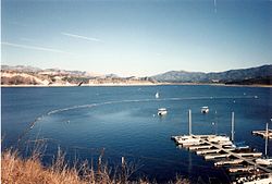
Cachuma Lake
View on Wikipedia
Key Information


Cachuma Lake is a reservoir in the Santa Ynez Valley of central Santa Barbara County, California on the Santa Ynez River adjoining the north side of California State Route 154. The artificial lake was created by the construction of Bradbury Dam, a 201 ft (61 m) earth-fill structure built by the U.S. Bureau of Reclamation in 1953. Its surface area covers 3,100 acres (1,300 ha), with a maximum design capacity of 205,000 acre⋅ft (253,000,000 m3), but it is currently limited to 188,000 acre⋅ft (232,000,000 m3) due to sediment accumulation.[1] The late-December 2022 and early-January 2023 storms dramatically raised the water level in the lake, from an average of 33% full to 100% full for the first time in 12 years.
History
[edit]Built by the U.S. Bureau of Reclamation in 1953, the name "Cachuma" comes from a Chumash village that the Spanish spelled "Aquitsumu", from the Barbareño Chumash word aqitsu'm, meaning "sign".[2]
The U.S. Bureau of Reclamation oversees the lake’s operations and maintenance. Five agencies that stretch from Santa Ynez to Carpinteria take water from Cachuma.[3] The Central Coast Water Authority (CCWA) extension of the California Aqueduct completed in 1997, is a 30–39-inch diameter pipeline (76–99 cm) that travels 42 miles (68 km) from Vandenberg Space Force Base through Vandenberg Village, Lompoc, Buellton, and Solvang and terminates at Cachuma.[4]
Water Levels
[edit]The water levels of the lake are highly variable, spilling in some years and receding to less than 10% of capacity in dry years.[5] Drought conditions can cause shortage in water supplies, as did the 2011-17 drought.[3]
In October 2016, the lake approached low levels not seen since the construction of Bradbury Dam. The lake level reached a minimum of 646.42 ft (197.03 m) on October 14, more than 106 ft (32 m) below the spillway elevation. At this time, the storage volume was only 14,057 acre-feet (17,339,000 m3), approximately 7.3% of capacity.[5]
In January and February 2017, a series of frequent rains raised the water level substantially. On one day, February 17, 2017, the lake rose by 25 feet (7.6 m) during the storm alone, followed by further increases from storm runoff.[6] By the end of February 2017, the Lake had become 44.5% full, with a total volume of 85,979 acre-feet (106,054,000 m3).[7] The Lake's water level declined again during the 2017-18 water year, with the Lake receding to less than one-third of its capacity.[8] By March 28, 2019, above-normal precipitation had restored Lake Cachuma to 78.0% of its capacity.[9][10]
Despite an abnormally dry January and February 2020, a wet March and April brought the lake to 77% of capacity as of April 7, 2020.[11]
Several consecutive atmospheric river storms coming in from the Pacific in late-December, 2022 and early-January, 2023 dramatically raised the water level in the lake, from an average of 33% full in late December, to nearly 100% full by January 15, 2023 for the first time in 12 years.[3] Further storms in February resulted in flood warnings for portions of Lompoc close to the river due to the water being released from the dam.[12]
Climate
[edit]This region experiences hot and dry summers, with some average monthly temperatures above 71.6 °F (22.0 °C). According to the Köppen Climate Classification system, Cachuma Lake has a hot-summer Mediterranean climate, abbreviated Csa on climate maps.[13]
| Climate data for Cachuma Lake, California, 1991–2020 normals | |||||||||||||
|---|---|---|---|---|---|---|---|---|---|---|---|---|---|
| Month | Jan | Feb | Mar | Apr | May | Jun | Jul | Aug | Sep | Oct | Nov | Dec | Year |
| Mean daily maximum °F (°C) | 67.2 (19.6) |
68.1 (20.1) |
71.2 (21.8) |
75.7 (24.3) |
79.8 (26.6) |
86.2 (30.1) |
92.1 (33.4) |
93.2 (34.0) |
90.6 (32.6) |
84.2 (29.0) |
74.8 (23.8) |
66.8 (19.3) |
79.2 (26.2) |
| Daily mean °F (°C) | 50.7 (10.4) |
51.8 (11.0) |
54.5 (12.5) |
57.5 (14.2) |
61.3 (16.3) |
65.8 (18.8) |
69.9 (21.1) |
70.9 (21.6) |
68.6 (20.3) |
63.6 (17.6) |
56.4 (13.6) |
50.1 (10.1) |
60.1 (15.6) |
| Mean daily minimum °F (°C) | 34.2 (1.2) |
35.4 (1.9) |
37.8 (3.2) |
39.3 (4.1) |
42.8 (6.0) |
45.3 (7.4) |
47.8 (8.8) |
48.5 (9.2) |
46.7 (8.2) |
44.1 (6.7) |
38.0 (3.3) |
33.4 (0.8) |
41.1 (5.1) |
| Average precipitation inches (mm) | 4.89 (124) |
5.29 (134) |
3.61 (92) |
1.31 (33) |
0.54 (14) |
0.06 (1.5) |
0.01 (0.25) |
0.00 (0.00) |
0.08 (2.0) |
0.80 (20) |
1.24 (31) |
3.30 (84) |
21.13 (535.75) |
| Source: NOAA[14] | |||||||||||||
Recreation
[edit]Santa Barbara County Parks offers cabin and yurt rentals, as well as RV, tent, and group camping. Gasoline and groceries are available at the general store.[15] There is a full boat and kayak rental facility with a bait and tackle shop where fishing licenses can be purchased. The lake is stocked with rainbow trout throughout the winter season, and fishing is open all year from shore or boat. There are five miles of hiking trails within the park, and Los Padres National Forest trails close by.
A large campsite on the south shore of Cachuma Lake is administered by the Santa Barbara County Park's division of the Community Services Department.
The University of California, Santa Barbara rowing team regularly practices and races at Cachuma Lake and erected a permanent boathouse there just prior to the 1982-1983 school year. The lake is also a popular destination for viewing bald eagles from seasonal tour boats.
Body contact activities such as swimming, wading, or water skiing in Cachuma Lake have been restricted since the park opened in the 1950s, reasoning that the lake was a reservoir people depend upon for drinking water. In May 2011, the no body contact regulation was revised to allow human-powered recreational watercraft such as kayaks and canoes on the lake as well as allow dogs on boats and eliminate "incidental body contact" with the water as a punishable offense.[16]
Solvang, California is approximately 10.5 mi (16.9 km) to the west of Lake Cachuma. The town of Santa Ynez, California is approximately 7.25 mi (11.67 km) to the west of Bradbury Dam.
Natural history activities and programs
[edit]Santa Barbara County Parks offers a variety of natural programs including wildlife lake cruises, nature walks, junior ranger programs, campfire programs on summer weekends, and a family-oriented live animal event in the fall. School and community group environmental education field trips are available all year.[17]
Neal Taylor Nature Center
[edit]Located in Santa Barbara, the Neal Taylor Nature Center, formerly the Cachuma Lake Nature Center, features exhibits and hands-on displays about the area's cultural and natural history, including local plants, animals, birds and geology. The nature center is open year-round[18] and admission is free. The center offers youth and adult workshops and lectures as well as school and youth nature education programs in partnership with the Santa Barbara County Parks natural history programs.[19]
-

-
 Campsite
 -
 Dock & boats


See also
[edit]References
[edit]- ^ "LAKE CACHUMA DAILY OPERATIONS" (PDF). January 23, 2017. Retrieved January 28, 2017.
- ^ Bright, William; Erwin Gustav Gudde (1998). 1500 California Place Names: Their Origin and Meaning. University of California Press. p. 29. ISBN 978-0-520-21271-8.
- ^ a b c Fausey, Callie (January 14, 2023). "Cachuma Fills and Flood Gates to Open". The Santa Barbara Independent. Retrieved January 15, 2023.
- ^ "State Water Project in Santa Barbara County". Central Coast Water Authority. March 10, 2003. Archived from the original on December 11, 2009.
- ^ a b "October 2016 Lake Cachuma Daily Operations" (PDF). CVO 2016 Reservoir Operations Reports. U.S. Bureau of Reclamation. Retrieved January 19, 2019.
- ^ Bolton, Tom. "Lake Cachuma in Santa Barbara County rising fast after potent winter storm". The Tribune. Retrieved February 24, 2017.
- ^ "Cachuma Reservoir". County of Santa Barbara Public Works Online. Retrieved February 24, 2017.
- ^ John Palminteri (September 30, 2018). "Cachuma Lake water supply holding up despite prolonged drought and weak winters". KEYT. Archived from the original on February 7, 2019. Retrieved February 5, 2019.
- ^ "Rainfall and Reservoir Summary" (PDF). Santa Barbara County - Flood Control District. March 28, 2019. Archived from the original (PDF) on February 26, 2019. Retrieved March 28, 2019.
- ^ Vasoyan, Andy (April 9, 2019). "Water Worries Waning After Wet Winter, According To Santa Barbara City Council". www.kclu.org. Retrieved April 10, 2019.
- ^ "Rainfall report" (PDF). countyofsb.org. Archived from the original (PDF) on February 26, 2019. Retrieved May 14, 2023.
- ^ Friedman, Jackson (February 25, 2023). "Lake Cachuma Releases Expected to Contribute to Flooding in Lompoc". The Santa Barbara Independent. Retrieved February 26, 2023.
- ^ "NOAA NCEI U.S. Climate Normals Quick Access". www.ncei.noaa.gov. Retrieved March 5, 2026.
- ^ "NOAA NCEI U.S. Climate Normals Quick Access". www.ncei.noaa.gov. Retrieved March 5, 2026.
- ^ Farnsworth, Beth (February 7, 2023). "Cachuma Lake reopens to boaters, rowers and fishing". News Channel 3-12. Retrieved February 7, 2023.
- ^ Ethan Stewart (April 21, 2011). "Paddling the Forbidden Waters". Santa Barbara Independent. Vol. 25, no. 275. p. 8. Retrieved December 30, 2011.
- ^ "Programs & Activities". www.countyofsb.org. Retrieved February 10, 2026.
- ^ "Cachuma Lake". www.countyofsb.org. Retrieved February 10, 2026.
- ^ "Links & Resources | The Neal Taylor Nature Center at Cachuma Lake". Retrieved February 10, 2026.
External links
[edit]- U.S. Geological Survey Geographic Names Information System: Cachuma Lake
- Cachuma Lake Website - official site
- Neal Taylor Nature Center - Neal Taylor Nature Center at Cachuma Lake
- County Parks Website - County of Santa Barbara
| International | |
|---|---|
| National | |
| Other | |
Cachuma Lake
View on GrokipediaGeography
Location and Setting
Cachuma Lake is situated at 34°35′12″N 119°58′51″W, with a surface elevation of 753 feet (229 meters) above sea level at full capacity.[5][6][7] The reservoir lies within the Santa Ynez Valley in Santa Barbara County, California, directly adjoining the Los Padres National Forest.[8] It is flanked by the Santa Ynez Mountains to the north and the San Rafael Mountains to the south, creating a scenic, mountainous setting amid expansive wilderness areas.[9] Approximately 25 miles northwest of Santa Barbara, the lake is accessible via State Route 154, also known as San Marcos Pass Road, which winds through the valley.[10][2] As part of the broader Central Coast watershed, Cachuma Lake is fed primarily by the Santa Ynez River, supporting regional water resources.[3]Physical Characteristics
Cachuma Lake is a man-made reservoir formed by Bradbury Dam, a zoned earthfill structure that impounds the Santa Ynez River in Santa Barbara County, California.[11] The dam stands 206 feet above the streambed and measures 279 feet from the bottom of the cutoff trench to its crest, with a total volume of 6,695,000 cubic yards of material.[11] Completed in 1953, it creates the lake as part of the federal Cachuma Project to store floodwaters for regional supply.[1] At full capacity, the reservoir covers a surface area of 3,100 acres with a shoreline extending 42 miles along the varied terrain of the Santa Ynez Valley.[1] Its maximum depth reaches approximately 138 feet near the dam, contributing to a total storage volume originally designed at 205,000 acre-feet but now reduced to 193,305 acre-feet due to sediment accumulation over decades.[12][13] The drainage area upstream encompasses 417 square miles, primarily fed by the Santa Ynez River and its smaller tributaries.[7] The lake's bathymetry features steep drop-offs along rocky sections near the dam and shallower bays in peripheral areas, influencing water mixing and circulation patterns.[14] Inflows from the Santa Ynez River and associated streams enter mainly from the north and east, creating dynamic hydrological conditions within the enclosed valley setting.[3]History
Pre-Construction and Naming
The name Cachuma derives from a Barbareño Chumash village known as Aquitsumu, recorded by Spanish explorers, with the term aqitsu'm translating to "sign" or "place of the sign" in the Chumash language, likely referring to a prominent rock formation used as a navigational landmark in the region.[15][16] This village was part of the broader Chumash territory along the Santa Ynez River, where indigenous communities maintained cultural and economic ties to the landscape for millennia prior to European contact.[17] Prior to the 20th century, the Chumash people utilized the Santa Ynez Valley, encompassing the area now occupied by Cachuma Lake, for hunting, gathering, and seasonal settlements, relying on the diverse ecosystems of oak woodlands, riparian zones, and coastal influences for sustenance and materials.[18] As skilled hunter-gatherers and fishermen, they harvested acorns, seeds, fish from the Santa Ynez River, and game such as deer and rabbits, while constructing dome-shaped dwellings from willow and other local resources to support semi-permanent villages.[19] These practices sustained a population estimated at over 25,000 Chumash across the central California coast on the eve of Spanish arrival in 1769, with the Santa Ynez area serving as a key inland extension of their coastal domain.[18] European exploration of the Santa Barbara region began in the late 18th century with Spanish expeditions, culminating in the establishment of the Santa Barbara Presidio in 1782 as a military outpost to secure the area against Russian and British interests.[20] The founding of Mission Santa Barbara in 1786 and Mission Santa Inés in 1804 further entrenched colonial presence, converting and incorporating local Chumash populations into mission labor systems for agriculture and ranching activities along the Santa Ynez Valley.[21] Following the secularization of the missions in the 1830s under Mexican rule, large land grants known as ranchos were distributed to former mission overseers and soldiers, transforming the valley into expansive cattle ranching operations that dominated the landscape through the 19th century.[22] By the early 20th century, persistent water scarcity in the arid Santa Barbara region, exacerbated by population growth and agricultural demands, drew federal attention to potential reservoir sites along the Santa Ynez River.[3] In the 1940s, severe groundwater depletion from over-pumping led to widespread rationing and fines in South Coast communities, prompting the Santa Barbara County Water Agency's formation in 1945 and a request for U.S. Bureau of Reclamation studies in 1941 to address the chronic deficiencies.[23] This culminated in federal authorization of the Cachuma Project in 1948 as a solution to store floodwaters and provide reliable supply for the water-deficient area.[24]Construction and Early Development
The Cachuma Project was initiated in the 1940s amid severe droughts and rapid population growth in Santa Barbara County following World War II, which heightened demands for a reliable water supply in the water-scarce South Coast region.[25] The project received authorization on March 4, 1948, from the Secretary of the Interior under the Federal Reclamation Act, enabling the U.S. Bureau of Reclamation to proceed with planning and development to store Santa Ynez River floodwaters for irrigation and municipal use.[1] Construction of the core infrastructure began in 1950, with the earthfill Bradbury Dam—originally named Cachuma Dam—completed in 1953 after three years of intensive work by the Bureau of Reclamation.[1] The dam, renamed in 1971 to honor C. W. "Brad" Bradbury, a prominent local water advocate and Santa Barbara County supervisor, measures 3,350 feet in crest length and stands 279 feet in structural height, with a hydraulic height of 201 feet.[26] Key components included the dam itself, which created a reservoir with a capacity of 193,305 acre-feet, along with supporting features like the Tecolote Tunnel and initial conduit systems to facilitate water diversion.[1] Early development faced several challenges, including contentious land acquisition efforts that involved negotiating with local ranchers, such as opposition from owners like Lewis Welch of the San Fernando Rey Ranch in the Santa Ynez Valley, whose properties were targeted for inundation.[24] Initial filling of the reservoir occurred between 1953 and 1954, submerging approximately 3,100 acres of former valley lands, including several prehistoric Chumash archeological sites such as SBA-891/2105 and SBA-2101/481, and establishing Lake Cachuma as a vital storage basin.[1][27] Construction also encountered engineering hurdles, such as methane gas explosions and high-temperature water inflows during tunnel boring, which delayed progress and required contractor changes.[28]Water Management
Reservoir Operations and Infrastructure
Cachuma Lake serves as the central storage facility for the Cachuma Project, providing supplemental water supplies to five member agencies: the Montecito Water District, Santa Barbara County Water Agency, Carpinteria Valley Water District, Goleta Water District, and Santa Ynez River Water Conservation District.[3] The project provides an annual yield of approximately 25,714 acre-feet, allocated among the five member agencies according to their entitlements, with the reservoir's maximum storage capacity of 193,300 acre-feet, delivered primarily through the 6.4-mile Tecolote Tunnel to the South Coast areas of Santa Barbara County and via river outlets to the Lompoc region.[11] The Cachuma Operation and Maintenance Board (COMB), a joint powers agency formed in 1956, manages diversions and distribution in coordination with the U.S. Bureau of Reclamation, which retains oversight of the dam and reservoir.[7] Key infrastructure includes Bradbury Dam's concrete-lined spillway, which has a capacity of 161,000 cubic feet per second to handle flood releases, and outlet works at the North Portal Intake Tower that control water flow into the Tecolote Tunnel, a 7-foot-diameter concrete-lined structure with a design capacity of 100 cubic feet per second.[11] The South Coast Conduit, a 26-mile pipeline system, further distributes water from the tunnel to downstream treatment facilities with a combined capacity of 45 million gallons per day.[11] In 1997, the Central Coast Water Authority completed a 42-mile pipeline connecting the California Aqueduct's Coastal Branch to Cachuma Lake, enabling importation of State Water Project supplies to augment local storage during shortages.[29] For ecological support, the system includes provisions for steelhead trout releases, such as controlled outflows through the Hilton Creek watering system and modifications to tributary barriers to facilitate fish passage below Bradbury Dam.[30] The U.S. Bureau of Reclamation provides operational oversight, enforcing guidelines that prioritize flood control, water delivery, and minimum environmental releases, including approximately 30 acre-feet per month from Lake Cachuma during periods of extremely low storage below 30,000 acre-feet.[31] Drought contingency measures involve coordinated reductions in allocations among member agencies and integration with imported State Water to maintain supplies, as demonstrated in response to prolonged dry periods.[3] Sediment management addresses ongoing siltation, which has reduced the reservoir's usable capacity from an original 205,000 acre-feet to approximately 193,000 acre-feet as of 2024; proposals for dredging and flushing, such as installing pipelines in the Tecolote Tunnel to remove accumulated debris, are under evaluation to further restore storage and flow efficiency.[32][33]Historical and Current Water Levels
Cachuma Lake has experienced significant fluctuations in water levels since its impoundment began in the 1950s, reflecting the variability of California's Mediterranean climate. In wet years, such as 1969 and 2023, the reservoir reached full capacity of approximately 192,978 acre-feet at an elevation of 753 feet above sea level. Conversely, during prolonged droughts, levels have dropped dramatically; the record low occurred in October 2016 at 7.3% capacity, or about 14,000 acre-feet, amid a multi-year dry period that strained regional water supplies. These trends are tracked through monthly storage data, with percentages calculated by dividing current acre-feet by the revised maximum capacity established in 2021.[34][35] A pivotal event in recent history was the series of atmospheric river storms from late 2022 to early 2023, which rapidly replenished the lake from 31% capacity in fall 2022 to 100% by mid-January 2023, prompting the opening of spill gates at Bradbury Dam for flood control. This refilling added over 140,000 acre-feet in a matter of weeks, marking the first spillover since 2011 and providing surplus water for groundwater recharge. Operators managed inflows exceeding 100,000 cubic feet per second through controlled releases to mitigate downstream flooding while preserving storage for dry periods.[36][37] As of November 10, 2025, Cachuma Lake stands at approximately 75.3% capacity, holding about 145,293 acre-feet at an elevation of 736 feet, following a gradual decline of nearly 8,000 acre-feet over the past month due to seasonal demand. This level represents a stable post-2023 recovery, though below the surcharge allowance for fish releases.[38] Water levels are primarily influenced by annual precipitation in the 417-square-mile Santa Ynez River watershed, upstream diversions from tributaries, evaporative losses during hot summers, and withdrawals to meet urban and agricultural demands across Santa Barbara County districts. For instance, the lake's yield averages 25,714 acre-feet annually under normal conditions, but this varies with inflows; dry years like 2016 amplified reliance on imports, while wet periods enable exports.[2][7]Ecology
Aquatic and Riparian Ecosystems
Cachuma Lake hosts a diverse array of fish species, including introduced largemouth bass (Micropterus salmoides), smallmouth bass (Micropterus dolomieu), channel catfish (Ictalurus punctatus), black crappie (Pomoxis nigromaculatus), bluegill (Lepomis macrochirus), and redear sunfish (Lepomis microlophus).[39][40] These species thrive in the lake's varied habitats, from shallow coves to deeper open waters, supporting a robust recreational fishery. However, as of August 2025, the California Office of Environmental Health Hazard Assessment issued a fish consumption advisory for black bass and other species due to elevated mercury levels.[41] Rainbow trout (Oncorhynchus mykiss) are stocked annually, with 16,000 pounds released from October through April by the California Department of Fish and Wildlife in cooperation with Santa Barbara County Parks, enhancing angling opportunities and maintaining population levels.[42] The lake's aquatic ecosystem features dense beds of submerged macrophytes in nearshore shallows, which serve as essential habitat for juvenile fish, invertebrates, and as a base for the food web by providing cover and oxygen through photosynthesis.[43] Water quality is generally suitable for drinking and recreation, with regular monitoring of parameters like temperature, dissolved oxygen, pH, and nutrients revealing a mesotrophic status influenced by agricultural and urban runoff in the watershed, which can elevate phosphorus and nitrogen levels during wet seasons.[44][45] Aeration systems implemented since the 1980s have helped mitigate eutrophication risks by improving oxygen levels and reducing nutrient accumulation in deeper waters.[45] Invasive species pose a potential threat; while zebra and quagga mussels (Dreissena polymorpha and Dreissena rostriformis bugensis) are absent, stringent boat inspection and decontamination protocols prevent their introduction, preserving the native aquatic community.[46] Riparian ecosystems along the Santa Ynez River immediately below Bradbury Dam are characterized by narrow bands of willow (Salix spp.) and cottonwood (Populus spp.) forests, which stabilize banks, filter sediments, and offer shaded habitat that moderates water temperatures for aquatic life.[47][48] These zones support biodiversity, including endangered Southern California steelhead trout (Oncorhynchus mykiss irideus), whose populations benefit from managed reservoir releases that mimic natural seasonal flows to facilitate spawning and juvenile rearing downstream.[49] However, the dam acts as a complete barrier to upstream migration, isolating the lake from anadromous connectivity and necessitating ongoing conservation efforts like flow augmentation under the Lower Santa Ynez River Fish Management Plan.[50] Seasonal hydrological variations, with higher winter releases promoting scour and habitat refreshment, contrast with low summer flows that can stress riparian vegetation and downstream biota.[51]Terrestrial Wildlife and Habitats
The surrounding Cachuma Lake Recreation Area, encompassing approximately 9,000 acres of diverse upland terrain, features a mosaic of terrestrial habitats shaped by the region's Mediterranean climate. These include oak woodlands dominated by coast live oak (Quercus agrifolia) and valley oak (Quercus lobata), which provide critical canopy cover and acorn resources for wildlife, alongside chaparral shrublands characterized by scrub oak (Quercus berberidifolia) and purple sage (Salvia leucophylla). Transitional zones between these shrublands and narrower riparian corridors along intermittent streams support a mix of native flora, such as California buckwheat (Eriogonum fasciculatum) and California sagebrush (Artemisia californica), fostering biodiversity in the area's rolling hills and canyons.[52][53][54] Terrestrial wildlife thrives in these habitats, with over 200 bird species recorded, including resident ospreys (Pandion haliaetus) and great blue herons (Ardea herodias) that utilize the woodland edges for foraging and nesting. A notable highlight is the resident pair of bald eagles (Haliaeetus leucocephalus), which established a nesting territory in 2013 and has been monitored annually by park rangers and conservation partners to track breeding success and habitat use. Mammalian species are equally prominent, with California mule deer (Odocoileus hemionus californicus) commonly grazing in oak savannas, while bobcats (Lynx rufus) and mountain lions (Puma concolor) prowl chaparral areas as apex predators, contributing to ecosystem balance.[55][56][57][53] Conservation efforts prioritize habitat integrity through the 2016 Cachuma Lake Resource Management Plan, which outlines strategies for vegetation management, including the removal of invasive weeds to preserve native plant communities and prevent erosion in upland zones. The plan also addresses protection for endangered species, with occasional sightings of California condors (Gymnogyps californianus) in the broader watershed prompting enhanced monitoring and habitat enhancements like perch sites. Recent wildfires, such as the 2024 Lake Fire that scorched nearby areas in the Santa Ynez Mountains, have underscored the need for fire-resilient practices, including controlled burns and post-fire revegetation to mitigate soil loss and support habitat recovery in chaparral and oak ecosystems.[58][58][59][60]Recreation and Visitor Services
Water-Based Activities
Cachuma Lake offers a variety of water-based recreational opportunities centered on boating and fishing, managed by Santa Barbara County Parks to balance public access with the reservoir's role as a drinking water supply.[9] Activities emphasize non-contact uses, with swimming, water-skiing, and windsurfing prohibited since the lake's creation in 1953 to protect water quality for municipal distribution, though as of 2025, the county is exploring policy changes to potentially allow swimming.[61][62] Boating is a primary attraction, with rentals available year-round through concessionaire ExplorUS at the marina, including motorized options such as 6-horsepower to 9.9-horsepower fishing boats accommodating 4 to 5 people, and larger 25-horsepower pontoon deck boats seating 8 to 12 passengers.[63] Non-motorized rentals include single and double kayaks as well as pedal boats for up to 4 people, providing accessible options for leisurely exploration.[63] Private boats can launch from the concrete ramp, subject to same-day access for qualifying vessels with current California registration, though the lake limits concurrent usage to 254 boats for safety and capacity management.[64][65] Motorized vessels must adhere to posted speed limits ranging from 3 mph in no-wake zones near docks and shorelines to a maximum of 40 mph in open areas, with all operators required to complete a vessel inspection for invasive species like quagga mussels upon entry.[66][67] Fishing is permitted year-round from boats, piers, or shorelines, requiring a valid California sport fishing license for anglers aged 16 and older, available for purchase at the marina bait shop.[39][68] The lake supports a diverse fishery, with rainbow trout stocked seasonally during cooler months by the California Department of Fish and Wildlife to enhance populations, alongside established largemouth bass, smallmouth bass, channel catfish, and bluegill. In 2025, the lake received its first trout stocking in January, with the reservoir at approximately 91% capacity following recent rains, enhancing fishing conditions.[69][39] Bag and possession limits follow California freshwater regulations, such as a 5-fish daily limit for trout and a 5-fish limit for bass over 12 inches, with popular hotspots including submerged structures near the dam and coves for bass and deeper waters for trout.[70] Occasional bass tournaments are hosted, drawing competitors to target trophy-sized fish in the reservoir's clear waters.[71] Guided tours and educational programs provide structured water access, though the traditional 90-minute narrated lake cruises for wildlife viewing, including bald eagles and otters, are currently out of service pending further notice due to operational updates.[72] Rowing programs, including those affiliated with the University of California, Santa Barbara, utilize the lake's 5,000 meters of flat water for training and community sessions through Santa Barbara Community Rowing, offering learn-to-row classes twice weekly over seven weeks.[73][74] Access to water-based activities is facilitated by the marina's launch ramp and dock facilities, open daily except for limited holiday closures on Thanksgiving (7 a.m. to 3 p.m.) and Christmas Day, with no broad restrictions tied to specific water levels like 20% capacity, though overall boating remains year-round barring extreme conditions.[64] All participants must follow body-contact prohibitions to maintain the lake's ecological integrity, such as through controlled fish stocking practices.[61][39]Land-Based Activities and Accommodations
Cachuma Lake Recreation Area provides a variety of land-based recreational opportunities, emphasizing trails and outdoor exploration within its 6,500-acre expanse surrounded by the Santa Ynez Mountains. The park maintains six shared-use trails suitable for hiking and mountain biking, with lengths varying from a short 0.25-mile interpretive loop to an extensive 12-mile route that traverses diverse terrain including oak woodlands and ridgelines.[75] Representative examples include the 2.5-mile Sweetwater Trail, which follows the reservoir's shoreline and offers panoramic views of the water and surrounding hills, and the 1.5-mile Mohawk Trail, a gentler path ideal for families meandering through riparian habitats.[75] These trails are multi-use but prohibit off-road motorized vehicles to preserve the natural environment and ensure user safety.[76] Equestrian activities are supported on designated paths, particularly in the Live Oak area, where miles of trails along the lake's north shore are reserved for horseback riding and hiking, excluding bicycles to minimize conflicts with horses.[77] The Tequepis Trail, a 4-mile one-way option, also accommodates equestrians alongside hikers and bikers, providing access to elevated vistas overlooking the Santa Ynez Valley.[75] All trails promote low-impact recreation, with signage encouraging visitors to stay on marked paths to protect sensitive habitats. Overnight accommodations cater to diverse preferences, with several hundred campsites available for tents and self-contained RVs scattered across the park's basic, lake-view, partial hookup, and full hookup areas.[78] Over 100 full hookup sites offer electrical, water, and sewer connections, while more than 30 partial hookup sites provide electrical and water; each includes a fire pit and picnic table, with additional amenities such as hot showers, flush toilets, potable water spigots, a dump station, and coin-operated laundry facilities.[78] The park features eight cabins in various configurations, including three that sleep six guests (with a queen bed, bunk bed, and sleeper sofa), three that sleep four (with two queen beds), and two ADA-accessible options sleeping two or four, all equipped with full bathrooms, kitchenettes, electricity, heating, private porches, and fire pits.[79] Seven yurts offer a glamping alternative, each sleeping three to six on platform beds, complete with lockable doors, interior lighting, heating, and screened windows for ventilation.[80][81] Reservations for campsites, cabins, and yurts are managed through the Santa Barbara County Parks Division website or by calling (805) 568-2460, available up to six months in advance, with a two-night minimum on weekends and three nights on holidays; fees vary seasonally, typically ranging from $30 to $200 per night depending on site type and amenities (campsites 55, yurts 120, cabins 200).[82][83] Group camping areas accommodate up to 120 people, suitable for organized outings.[84] Picnicking is permitted in designated areas equipped with tables and grills, enhancing day-use visits with shaded spots near trails.[76] Accessibility features include ADA-compliant cabins and paved pathways at select picnic sites and trailheads, ensuring broader participation.[79] The park operates year-round, though summer fire restrictions limit open flames to established pits and prohibit ground fires or unattended burns to mitigate wildfire risk.[76] During periods of low water levels due to drought, certain areas may see adjusted access, but core land-based facilities remain available, with no major restrictions as of 2025 due to high reservoir levels.[9] These activities complement the park's educational programs by providing immersive settings for nature observation.Educational and Interpretive Programs
The Neal Taylor Nature Center, located within the Cachuma Lake Recreation Area in a historic ranch house, serves as the primary hub for educational and interpretive programs focused on the local environment and cultural history. Admission is by donation, with groups of 15 or more required to book in advance, and the center operates year-round on Thursdays through Saturdays from 10 a.m. to 4 p.m. and Sundays from 10 a.m. to 2 p.m., though holiday hours may vary.[85][86][87] The center features interactive exhibits on Chumash Native American culture, regional geology, and wildlife, including taxidermy specimens, hands-on activities, puzzles, and games that highlight local flora, fauna, weather patterns, and the construction of Bradbury Dam. A native plant garden behind the center offers a wheelchair-accessible interpretive trail with labeled species from the Santa Ynez River Valley and Santa Barbara region, complete with QR codes for additional information, encouraging visitors to explore chaparral, oak woodlands, and riparian habitats. These exhibits aim to foster appreciation for the Santa Ynez watershed and its ecosystems.[88][52][87] Educational programs include Junior Ranger activities such as the Nature Center Detectives scavenger hunts tailored for ages 3-6, 6-12, and teens/adults, where participants earn prizes while learning about biodiversity and natural processes, with docent assistance available. Guided nature walks along the 0.5-mile Don Wimpress Trail provide easy access to local ecology, accompanied by downloadable trail guides. School field trips for K-12 students, coordinated year-round with the Santa Barbara County Parks Department, combine lake cruises, nature walks, and docent-led tours covering topics like water cycles, watersheds, flora, and fauna; over 3,600 students from 65 schools participated in the most recent year reported. The Trout in the Classroom initiative, running January through March, allows visitors to observe trout life cycles from eggs to fry, emphasizing stream and river ecosystems.[89][86][90] Special events enhance interpretive offerings, such as the quarterly Food for Thought lecture series on Sundays, featuring topics like Native American culture and environmental history for adults, with donation-based admission. Seasonal highlights include the summer Going Batty program with bat exhibits at dusk, the October Creepy Creatures Halloween event with live animals and crafts, and the annual Fish Derby in April, a two-day fundraiser promoting fishing and watershed awareness. Monthly wildlife cruises are integrated into school programs to observe local species, supporting hands-on learning about biodiversity.[89][86][91] The center operates under a 25-year lease agreement with both Santa Barbara County and the U.S. Bureau of Reclamation, facilitating water education initiatives tied to the agency's management of Cachuma Lake resources. Programs emphasize environmental stewardship, teaching visitors about natural processes and protection to minimize impacts on the lake and surrounding habitats, aligning with broader goals of public understanding and conservation.[92][3][89]References
- https://en.wikivoyage.org/wiki/Cachuma_Lake_Recreation_Area