

Community hub
Recent from talks
Contribute something
Nothing was collected or created yet.
Monte Cinto
View on WikipediaThis article needs additional citations for verification. (May 2007) |
Monte Cinto (Corsican: Monte Cintu) is the highest mountain on the island of Corsica, a region of France.
Key Information

Geography
[edit]The elevation of the mountain is 2,706 metres (8,878 ft) and so is its prominence, making it one of the most prominent peaks in Europe. It is the highest peak of the Monte Cinto massif, one of the four main massifs in Corsica.
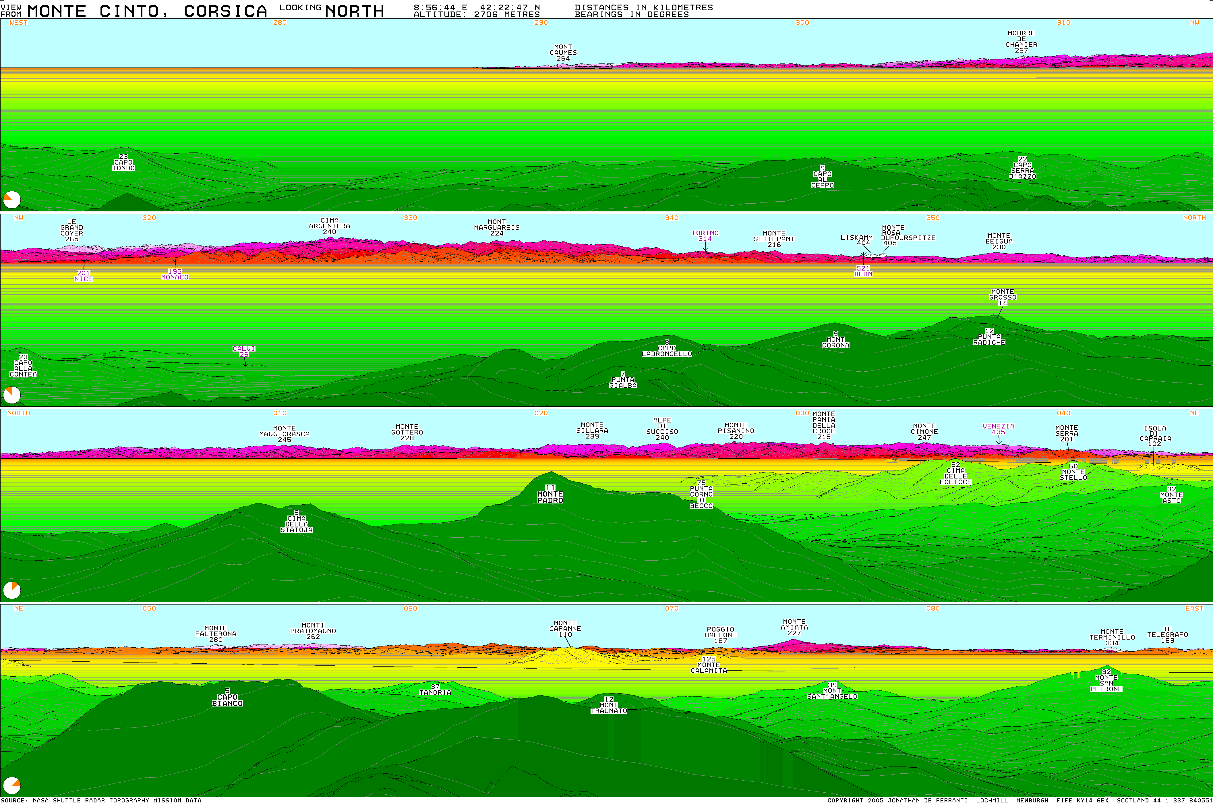
Its location gives it a theoretical panorama of mountains on mainland Europe stretching from near Marseille to Rome. The most distant mountain theoretically visible is Monte Rosa in Italy, just west of north, approximately 405 km (252 mi) away.[2]
History
[edit]The first known ascent of Monte Cinto was on 6 June 1882, by a party led by Édouard Rochat who reached the summit via the mountain's southern slopes. On 26 May 1883 a party led by the English mountaineer Francis Fox Tuckett, and including the French guide François Devouassoud and the landscape painter Edward Theodore Compton, also ascended the mountain by the pass that now bears Tuckett's name.
Today, the GR 20 hiking trail passes close to Monte Cinto, and walkers can make a short detour to the summit.
See also
[edit]References
[edit]- ^ a b "Europe Ultra-Prominences" Archived 2017-06-09 at the Wayback Machine Peaklist.org. Retrieved 2012-03-05.
- ^ http://www.viewfinderpanoramas.org/panoramas/EUR/CINTO-N.gif Archived 2017-03-12 at the Wayback Machine [bare URL image file]
External links
[edit]- Computer generated digital panoramas from Monte Cinto: North Archived 2017-03-12 at the Wayback Machine South Archived 2007-10-08 at the Wayback Machine
- More information and trip report
- "Monte Cinto, France" on Peakbagger
Landforms of the Haute-Corse department | ||
|---|---|---|
| Massifs |  | |
| Peaks | ||
| Passes | ||
| ||
This Haute-Corse geographical article is a stub. You can help Wikipedia by expanding it. |
Monte Cinto
View on GrokipediaGeography
Location and Coordinates
Monte Cinto is situated in the Haute-Corse department of Corsica, France, within the island's central-northern mountainous region, at precise coordinates of 42°22′47″N 8°56′45″E.[4] This positioning places it as the dominant feature of the island's rugged interior, rising prominently from the surrounding terrain.[2] The peak attains an elevation of 2,706 meters (8,878 feet) above sea level, establishing it as Corsica's highest summit.[2] Its topographic prominence measures 2,706 meters, a value equal to its elevation that qualifies Monte Cinto as an ultra-prominent peak due to its status rising directly from coastal lowlands without higher intervening summits.[4] Additionally, the peak exhibits a topographic isolation of 223.28 kilometers to the nearest higher elevation, underscoring its remote dominance in the regional landscape.[4] These metrics, derived from lidar surveys and official mapping data, highlight Monte Cinto's exceptional scale within the Mediterranean's island geography.[5] As the namesake and highest point of the Monte Cinto massif—one of Corsica's four primary massifs, alongside those of Monte Rotondo, Monte Renoso, and Monte Incudine—the peak anchors a chain of summits that forms a natural divide across the island's spine.[6] Specifically, the massif separates the Niolo valley, characterized by its deep gorges and the Golo River, to the south from the narrower, more dramatic Asco valley to the north.[7] In terms of accessibility, Monte Cinto lies approximately 30 kilometers northwest of the inland town of Corte and about 40 kilometers southeast of the coastal town of Calvi, positioning it as a central hub for regional exploration while remaining embedded in remote alpine terrain.[2]Topography and Surrounding Features
Monte Cinto exhibits a rugged, craggy profile formed by its granitic composition, with steep southern slopes descending sharply toward the Niolo region and more gradual northern approaches rising from the Asco Valley.[2] The peak's dramatic silhouette is accentuated by exposed ridges and rocky outcrops, contributing to its prominence within the landscape.[8] The mountain serves as the central feature of the Monte Cinto massif, which spans approximately 18 km in diameter and separates the Asco Valley to the north from the Golo River valley to the south.[2][7] This massif includes subsidiary peaks such as Capu Tafunatu, rising to 2,335 m southeast of the main summit near the Paglia Orba.[9][10] The surrounding terrain features deep gorges and forested lower slopes, with the Asco Valley characterized by narrow, winding paths along the river and the Golo Valley marked by broader, more accessible plateaus.[7][11] From the summit, climbers are rewarded with expansive panoramic views encompassing the Tyrrhenian Sea to the east, the Ligurian coast to the north and west, and on exceptionally clear days, visibility extending up to 405 km to Monte Rosa in the Alps.[2][12] The elevated position also reveals the island's central ridge summits, including Monte Rotondo and Monte d'Oro.[2] The peak's topography has shaped local micro-terrain through glacial processes, forming cirques such as the Caldane cirque on its northwestern flanks and prominent ridges that define access routes.[13][14] Extensive boulder fields and scree slopes dominate the upper elevations, resulting from weathering of the granitic bedrock and past ice movements, creating challenging, unstable surfaces around the summit area.[15][16]Geology
Formation and Structure
Monte Cinto, the highest peak in Corsica at 2,706 meters, forms part of the island's central crystalline massif, which originated during the Alpine orogeny through the collision of the African and European plates. This tectonic event, spanning the Eocene to Miocene epochs (approximately 56–5 million years ago), involved the subduction of the Ligurian Tethys oceanic crust beneath the European margin, leading to continental convergence and the stacking of thrust sheets in northeastern Corsica.[17] The process began with initial contraction in the late Paleocene to middle Eocene (67–41 Ma), followed by the emplacement of high-pressure metamorphic units in the Eocene.[17] Uplift of the Corsican basement rocks, including those underlying Monte Cinto, resulted from intense compressional forces during subduction and subsequent continental collision, elevating the central mountain chain through crustal shortening and isostatic rebound. Diachronous exhumation occurred from southeast to northwest across Corsica-Sardinia between 67 and 49 Ma, with significant surface uplift in the central chain accelerating in the Oligocene-Miocene (around 30–20 Ma) due to ongoing compression and the reversal of earlier extensional shear zones.[18] This uplift was further influenced by post-12 Ma tectonic adjustments tied to Tyrrhenian extension, though the primary elevation stems from Eocene-Miocene orogenic compression.[18] The massif exhibits prominent structural features, including reactivated Variscan fault lines (such as NE-SW strike-slip faults) and compressional folds that contribute to its asymmetric profile, with steeper eastern slopes due to differential thrusting and erosion. These elements reflect the overprinting of Alpine deformation on pre-existing Hercynian structures, forming a complex orogenic wedge with ophiolitic complexes and metamorphic folds.[17] Ongoing fluvial and glacial erosion since the Miocene has sculpted the current topography, exposing the elevated basement while maintaining the mountain's rugged form.[18]Rock Types and Composition
Monte Cinto's geological foundation consists primarily of rocks from the Hercynian (Variscan) basement, including Paleozoic metamorphic units such as micaschists, paragneisses, and quartzites, which form the core crystalline structure of the mountain.[19] These metamorphic rocks are intruded by Carboniferous plutonic bodies, notably Mg-K calc-alkaline and calc-alkaline granites that contribute to the mountain's resistant framework.[20] The western and central portions of Corsica, encompassing Monte Cinto, are dominated by this extensive granitic batholith, which underlies much of the island's axial chain.[18] Overlying the basement are Permian volcanic rocks associated with the Monte Cinto Caldera, an 18 km diameter structure filled with comenditic pyroclastic deposits including breccias, pumice flows, and ignimbrites.[21] These volcanics exhibit a persilicic, alkaline composition rich in quartz and alkali feldspar, with high K₂O content and accessory minerals such as aegirine, arfvedsonite, and zircon; the groundmass is often devitrified, reflecting rhyolitic affinities.[20] Adjacent areas feature Tertiary volcanic sequences, but the mountain's core remains anchored in the Paleozoic-Carboniferous basement, with the Permian layers preserved as a volcanic-plutonic association of A-type granites.[22] Erosion on Monte Cinto has produced extensive boulder-scree fields and talus slopes, primarily derived from glacial and periglacial weathering of the granitic and metamorphic rocks during Pleistocene glaciations. These features are prominent on the steeper slopes, where frost action and freeze-thaw cycles have fragmented the weather-resistant quartz- and feldspar-rich lithologies into angular debris accumulations.Climate and Ecology
Climatic Conditions
Monte Cinto features a Mediterranean mountain climate, with mild and wet winters alongside hot, dry summers at lower elevations, shifting to harsher alpine conditions above 2,000 meters where temperatures decrease and precipitation often falls as snow.[23] This transition is influenced by the island's topography, exposing higher slopes to persistent westerly winds.[2] At the summit, summer temperatures typically average between 5°C and 10°C during the day, while winter conditions frequently drop to -10°C or below, with extreme lows reaching -15°C and highs occasionally up to 20°C in milder periods.[24] Annual precipitation ranges from 1,500 to 2,000 mm, predominantly occurring from November to April as snowfall, accompanied by frequent fog.[25] Strong westerly winds, often exceeding 100 km/h, are common, particularly during stormy periods, contributing to rapid weather changes.[26] Seasonal variations are pronounced, with snow cover persisting for 4 to 6 months annually, from late autumn through spring, which significantly affects accessibility and requires preparation for mountaineers.[27] This extended snow season aligns with the peak precipitation months, enhancing the alpine character of the upper reaches.[28]Biodiversity and Habitats
Monte Cinto's biodiversity is characterized by distinct altitudinal vegetation zones shaped by the mountain's elevation and Mediterranean climate influences. Below 1,000 meters, the lower slopes feature maquis shrubland dominated by sclerophyllous species such as Quercus ilex (holm oak) and aromatic plants like Erica arborea (tree heath) and Stachys corsica, an endemic shrub.[29] Between approximately 1,000 and 1,800 meters, dense forests of Pinus nigra subsp. laricio (Corsican pine) prevail, often mixed with Abies alba (silver fir) and Fagus sylvatica (European beech) on north-facing slopes, creating a montane broadleaf and conifer habitat.[29] Above 1,800 meters, alpine meadows and rocky terrains support herbaceous communities, including endemic species like Mentha corsica (Corsican mint) and cushion plants adapted to harsh conditions.[29] The fauna of Monte Cinto includes several iconic and endemic species that thrive in its varied elevations. The Corsican mouflon (Ovis aries musimon), a wild sheep and symbol of the island's wilderness, maintains significant populations in the Monte Cinto massif, particularly in open meadows and scree areas above 1,500 meters.[30] Raptors such as the golden eagle (Aquila chrysaetos) patrol the skies over the mountain's peaks and valleys, preying on smaller mammals and birds.[31] The Corsican nuthatch (Sitta whiteheadi), an endemic bird restricted to mature pine forests, is particularly abundant in the Pinus laricio stands around Monte Cinto, foraging on tree bark for insects.[32] Invertebrates contribute to the diversity, with numerous endemic species among the Chironomidae (non-biting midges) recorded in the region's aquatic and riparian zones.[33] Key habitats on Monte Cinto support specialized communities, enhancing its role as a biodiversity refuge. Scree slopes on the upper flanks host lichens and pioneer plants adapted to unstable substrates, providing microhabitats for endemic arthropods.[29] Glacial cirques and associated wetlands, known as pozzines, feature waterlogged meadows with carnivorous plants like Pinguicula corsica (Corsican butterwort), fostering amphibians and insects.[29] High-altitude tarns, such as those near the summit, sustain aquatic life including endemic invertebrates and support breeding for birds like the dipper (Cinclus cinclus).[29] Overall, Corsica's flora exhibits a 12.7% endemism rate (284 species out of approximately 2,200 native taxa), with Monte Cinto serving as a critical isolation-driven refuge where 43% of 131 alpine taxa are endemic, including 34 strictly Corsican species.[34][29]History
Pre-20th Century References
Ancient Roman geographers described Corsica's interior as a formidable mountainous spine, implicitly encompassing peaks like Monte Cinto, which forms part of the island's central range rising to over 2,700 meters. Strabo, in his Geography (ca. 7 BCE–23 CE), characterized the island as rough and largely impracticable, with its steep mountains and dense forests sheltering inhabitants who lived by brigandage rather than settled agriculture. Similarly, Ptolemy's Geography (ca. 150 CE) provided coordinate-based descriptions of Corsica's topography, including mountain features that correspond to the Monte Cinto massif's location in the northwest, portraying it as a dominant height amid the island's rugged spine. In medieval and Renaissance cartography under Genoese control (1347–1768), Monte Cinto was depicted as a key element of Corsica's imposing mountain barrier, symbolizing the island's isolation and defensibility. Genoese maps, often based on nautical charts and isolari like Cristoforo Buondelmonti's Liber insularum archipelagi (ca. 1420), illustrated a continuous chain of peaks dividing the island into eastern and western zones, with Monte Cinto's prominence underscoring the interior's inaccessibility to outsiders.[35] These representations prioritized coastal fortifications but highlighted the mountains' role in hindering control over the hinterland.[35] Local Corsican lore from the 14th to 18th centuries revered Monte Cinto as a vital landmark in pastoral traditions and a sanctuary for resistance against Genoese rule. Shepherds navigating transhumance routes across the island's interior relied on its distinctive silhouette for orientation, integrating it into oral stories of endurance amid harsh terrain.[36] During periods of unrest, the peak's remote wildernesses served as hideouts for rebels and bandits evading Genoese patrols, fostering legends of defiance in the Niolo region's fastnesses.[36] After France's 1768 annexation, 19th-century surveys marked the onset of systematic documentation of Monte Cinto in French colonial mappings. Early topographic efforts, drawing on geodetic operations from 1770–1791, identified the peak's height and centrality within Corsica's northwest massif. The 1824 Carte topographique de la Corse, compiled by surveyors like Testevuide and Bédigis, provided one of the first detailed representations, noting its elevation and role in the island's hydrological and orographic framework.[37]Exploration and First Ascents
The first recorded ascent of Monte Cinto took place on 6 June 1882, led by Édouard Rochat, who approached via the southern slopes from the Golo Valley, navigating challenging terrain that included steep inclines and loose rock typical of the massif's topography.[38] This expedition marked the initial documented summit, as prior local knowledge of the peak remained limited to pastoral herding routes without evidence of full ascents.[39] The second major ascent followed closely on 26 May 1883, accomplished by the English mountaineer Francis Fox Tuckett, accompanied by Edward Theodore Compton and guide François Devouassoud, who traversed from the north via a col later named Tuckett's Pass after their route.[38] This climb, building on Tuckett's earlier 1881 reconnaissance around the massif—where poor weather had thwarted a summit attempt—highlighted the peak's northern accessibility despite its rugged cirques and exposed ridges.[39] In the early 20th century, Monte Cinto saw increased integration into formalized routes by the French Alpine Club (Club Alpin Français), which promoted standardized paths and refuges to facilitate safer access amid growing interest in Corsican mountaineering. Post-World War II efforts focused on systematic exploration to support trail infrastructure, including surveys in the 1970s that mapped the massif for the GR 20 long-distance path, conceived by the Parc Naturel Régional de Corse around 1970 and officially waymarked in 1971.[40] These surveys, involving topographic assessments from both northern and southern approaches, reaffirmed the absence of any pre-1882 documented summits, attributing earlier omissions to the peak's isolation and lack of organized alpine activity.[38]Recreation and Access
Hiking Routes
The primary hiking route to the summit of Monte Cinto follows a detour from the GR20 long-distance trail during stage 4, bypassing the hazardous Cirque de la Solitude section, which was closed after a 2015 rockfall but has been optionally reopened since around 2018 with via ferrata aids for equipped hikers.[41] This non-technical path branches off near the cirque area, ascending to the Pointe des Éboulis at 2,607 m before continuing to the summit; the round-trip side excursion from the junction near this point typically takes 2-4 hours and involves about 200 m of elevation gain, making it suitable for fit hikers with experience in rugged terrain.[42][43][44] An alternative route starts from the Asco Valley at approximately 1,200 m elevation, following an 8-10 km out-and-back path. This trail provides a more direct valley ascent for those not on the GR20, with well-marked sections leading through alpine meadows and rocky slopes.[2] Hiking to Monte Cinto is best undertaken from June to September, when snow has melted and trails are accessible without specialized equipment; in winter months, persistent snow cover necessitates snowshoes for safe navigation.[45][3] Supporting infrastructure includes the seasonal Refuge d'Asco, a hut offering basic overnight accommodations from mid-June to mid-September, along with GR20 trail markers consisting of red-and-white paint blazes for guidance; there are no permanent facilities at the summit itself.[46][47]Climbing and Mountaineering
Monte Cinto offers advanced mountaineering opportunities on its steep faces and ridges, demanding technical skills and experience in mixed terrain. The northern face features the Tuckett Route, a classic mixed climb graded AD (Assez Difficile) that combines rock scrambling, snow, and ice sections up to several pitches long. This route, first explored in the late 19th century, ascends granite walls with exposure and requires proficiency in placing protection on variable rock quality, often complicated by the mountain's schist and granite composition that can loosen under foot. The southern face provides access via the historic Rochat path, the original ascent route from 1882, rated around PD+ (Peu Difficile plus) for its blend of snowfields and rocky ledges.[48] Northern ridges, including approaches to the summit plateau, involve UIAA II-III scrambles on solid granite, suitable for experienced parties but with sustained exposure.[2] Nearby, the prominent Capu Tafunatu spire in the Monte Cinto massif delivers multi-pitch traditional climbing, highlighted by its north ridge with a crux chimney at UIAA III and exposed traverses past its iconic natural arch.[49] In winter, the east face holds potential for ice climbs on frozen couloirs, though conditions vary and demand advanced alpine techniques.[2] Essential gear for higher routes includes crampons and an ice axe to navigate snow and ice, particularly on north- and east-facing aspects where conditions persist into early summer.[50] Ropes, helmets, and rock gear are recommended for the mixed and trad sections, given the objective hazards of rockfall on loose slabs and avalanche risk in steeper gullies during unstable weather.[43][51] Fast ascents from the Haut Asco trailhead can take fit climbers under three hours to the summit, though technical variants extend times significantly.[3]Cultural and Conservation Aspects
Symbolism in Corsican Culture
Monte Cinto, often referred to as the "roof of Corsica" due to its status as the island's highest peak at 2,706 meters, symbolizes the rugged resilience and independent spirit of the Corsican people, whose mountainous terrain historically provided refuge during periods of resistance against foreign rule.[52][53] This emblematic role underscores the mountain's embodiment of Corsica's unyielding geography, which fostered a culture of self-reliance and defiance.[54] In Corsican folklore, Monte Cinto features prominently in tales of ancient shepherds and notorious bandits who sought sanctuary in its remote slopes and surrounding valleys, evading authorities and vendettas amid the harsh, impenetrable terrain.[55] These narratives, passed down through oral traditions, portray the peak as a bastion of freedom and survival, intertwined with the island's pastoral heritage.[36] The mountain's association extends to Corsica's polyphonic singing traditions, known as paghjella, which is performed in rural mountain communities near sites like the Niolu Valley at the base of Monte Cinto, where the haunting, a cappella chants echo themes of exile, nature, and communal bonds.[56][57] In modern Corsican culture, Monte Cinto appears in literature as a backdrop to stories of vendetta and island identity, such as in Guy de Maupassant's The Corsican Bandit (1883), where the peak frames scenes of outlaw life, and Prosper Mérimée's Colomba (1840), which evokes the vendetta spirit amid Corsica's towering mountains.[55][58] It serves as an emblem of national pride, reinforcing its status as a site of cultural affirmation. As an icon of the "Île de Beauté," Monte Cinto anchors tourism branding, highlighting Corsica's wild beauty and adventurous heritage in promotional materials.[59] Artistically, the mountain has inspired 19th-century Romantic depictions of Corsican landscapes, including Edward Lear's etchings in Journal of a Landscape Painter in Corsica (1870), which capture the island's sublime wilderness.[60] Contemporary photography continues this tradition, portraying Monte Cinto in panoramic vistas that emphasize its enduring allure as a symbol of untamed natural and cultural legacy.[61]Protected Status and Management
Monte Cinto and its surrounding massif form a key component of the Parc Naturel Régional de Corse, established in 1972 to safeguard the island's natural heritage, covering approximately 40% of Corsica's land area. This regional park encompasses diverse ecosystems, including high-altitude montane forests and alpine meadows, with Monte Cinto as its highest peak at 2,706 meters. The area is also designated under the European Union's Natura 2000 network, which includes several sites within the park aimed at protecting endangered habitats and species through habitat conservation and sustainable management practices.[62][63] The Monte Cinto massif serves as the core of protected zones such as the broader Cinto-Restonica area, where conservation efforts focus on preserving endemic biodiversity amid increasing pressures. Primary threats include over-tourism, which has led to significant trail erosion along popular routes like the GR20, attracting approximately 30,000 hikers annually and straining fragile alpine soils. Climate change exacerbates these issues by reducing seasonal snow cover, altering water regimes and threatening high-elevation species adapted to cooler conditions, while invasive alien species compete with native flora in Mediterranean island ecosystems. To address these, proposals for implementing visitor quotas on sensitive trails like the GR20 have been discussed by regional authorities to balance access with environmental protection.[64][65][66][67] Management responsibilities for the area fall under the Parc Naturel Régional de Corse and the Office de l'Environnement de la Corse, which oversee trail maintenance to prevent further degradation and ensure safe access. Ongoing monitoring programs track mouflon populations, a key endemic ungulate, assessing impacts from habitat fragmentation and competition with introduced species, alongside fire risk assessments given Corsica's vulnerability to wildfires that threaten pine-dominated forests. Conservation initiatives include reforestation projects planting endemic Corsican black pine (Pinus nigra subsp. laricio) to restore fire-resilient habitats in the massif, as well as educational campaigns promoting sustainable hiking practices to minimize human impact on trails and wildlife.[68][69][70][71]References
- https://commons.wikimedia.org/wiki/File:Carte_topographique_de_la_Corse,_1824_(15503003).jpg