Hubbry Logo
search
logo
2320153

Napo River

logo
Community Hub0 Subscribers
Read side by side
from Wikipedia
Napo river
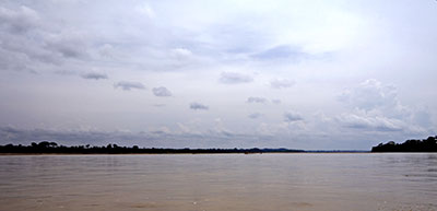
The Napo River to the east of Coca
Map of the Amazon Basin with the Napo River highlighted
Location
Countries
Physical characteristics
Source 
 • locationConfluence of Jatunyaçu and Anzu, Ecuador
 • coordinates1°2′48.6204″S 77°48′27.4392″W / 1.046839000°S 77.807622000°W / -1.046839000; -77.807622000
 • elevation430 m (1,410 ft)
2nd source 
 • locationJatunyaçu–Verdeyaçu, Andes, Ecuador
 • coordinates0°38′22.6248″S 78°3′29.1924″W / 0.639618000°S 78.058109000°W / -0.639618000; -78.058109000
 • elevation3,419 m (11,217 ft)
3rd source 
 • locationJatunyaçu–Mulatos, Andes, Ecuador
 • coordinates0°53′55.0464″S 78°24′32.8824″W / 0.898624000°S 78.409134000°W / -0.898624000; -78.409134000
 • elevation3,871 m (12,700 ft)
4th source 
 • locationAnzu River, Andes, Ecuador
 • coordinates1°23′30.408″S 78°4′48.7668″W / 1.39178000°S 78.080213000°W / -1.39178000; -78.080213000
 • elevation1,430 m (4,690 ft)
MouthAmazon River
 • location
70 km (43 mi) downstream from Iquitos, Loreto Region, Peru
 • coordinates
3°27′28″S 72°43′3″W / 3.45778°S 72.71750°W / -3.45778; -72.71750
 • elevation
78 m (256 ft)
Length1,130 km (700 mi)[1]
Basin size103,307.79 km2 (39,887.36 sq mi)[2]
Discharge 
 • locationFrancisco de Orellana (near mouth)
 • average(Period: 1971–2000)7,147.8 m3/s (252,420 cu ft/s)[2]
 • minimum3,200 m3/s (110,000 cu ft/s)[3]
 • maximum10,800 m3/s (380,000 cu ft/s)[3]
Discharge 
 • locationMazán (Bella Vista)
 • average(Period: 1991–2023)7,000 m3/s (250,000 cu ft/s)[4]
 • minimum3,250 m3/s (115,000 cu ft/s)[4]
 • maximum11,200 m3/s (400,000 cu ft/s)[4]
Discharge 
 • locationSanta Clotilde
 • average(Period: 2002–2011)5,895 m3/s (208,200 cu ft/s)[5]
Discharge 
 • locationNueva Rocafuerte
 • average(Period: 2001–2009)2,032 m3/s (71,800 cu ft/s)[5]
Discharge 
 • locationPuerto Francisco de Orellana
 • average(Period: 2001–2009)1,105 m3/s (39,000 cu ft/s)[5]
Basin features
ProgressionAmazonAtlantic Ocean
River systemAmazon River
Tributaries 
 • leftJatunyaçu, Misahualli, Payamino, Coca, Aguarico, Tamboyaçu
 • rightAnzu, Llocullón, Tiputini, Yasuní, Anahiri, Curaray, Tacshacuraray, Mazán

The Napo River (Spanish: Río Napo) is a tributary to the Amazon River that rises in Ecuador on the flanks of the east Andean volcanoes of Antisana, Sincholagua and Cotopaxi.

The total length is 1,075 km (668 mi). The river drains an area of ca 103,000 km2. The mean annual discharge at Mazán 6,800 m3/s (240,000 cu ft/s).[6][7][8]

Geography

[edit]
Village along the west bank of Napo River in Peru, a few miles above confluence with the Amazon. The land visible beyond the waterway is an island in the river.

Before it reaches the plains it receives a great number of small streams from impenetrable, saturated and much broken mountainous districts, where the dense and varied vegetation seems to fight for every piece of ground. From the north it is joined by the Coca River, having its sources in the gorges of Cayambe volcano on the equator, and also a powerful river, the Aguarico having its headwaters between Cayambe and the Colombia frontier. From the west, it receives a secondary tributary, the Curaray, from the Andean slopes, between Cotopaxi and the Tungurahua volcano. From its Coca branch to the mouth of the Curaray the Napo is full of snags and shelving sandbanks and throws out numerous canoes among jungle-tangled islands, which in the wet season are flooded, giving the river an immense width. From the Coca to the Amazon it runs through a forested plain where not a hill is visible from the river - its uniformly level banks being only interrupted by swamps and lagoons. From the Amazon the Napo is navigable for river craft up to its Curaray branch, a distance of about 216 mi (348 km), and perhaps a bit further; thence, by painful canoe navigation, its upper waters may be ascended as far as Santa Rosa, the usual point of embarkation for any venturesome traveller who descends from the Quito tableland. The Coca river may be penetrated as far up as its middle course, where it is jammed between two mountain walls, in a deep canyon, along which it dashes over high falls and numerous reefs. This is the stream made famous by the expedition of the Spanish conquistador Gonzalo Pizarro.

Hydrometric stations on the Napo River:

Station River kilometer (rkm) Elevation (m) Drainage basin

(km2)

Average discharge

(m3/s)

[9][2] [10]
Lower Napo
Francisco de Orellana 0 78 103,307.79 7,147.8 6,611
Mazán 79.76 85 100,518 7,033 6,464.5
Bellavista 194.51 105 90,305.3 6,416.1
Santa Clotilde 256.24 113 85,770 6,124.4 5,700
Campo Serio 421.35 140 50,342.9 3,430.3
Cabo Pantoja 546.8 166 44,698.2 3,007.5 3,280
Nuevo Rocafuerte 574.1 173 27,489.4 1,937.3 2,032
Pañacocha 673 203 21,731.4 1,552.1
Upper Napo
Puerto Francisco de Orellana 782 243 12,343 1,016 1,105
Puerto Napo 950 427 4,182.4 260.9 377.6

Discharge

[edit]

Napo River at Bellavista average (Q), dominante (Qd) discharge (m3/s) and sediment load (S – million ton/year). Period from 1991/09–2009/08:

Water year Q S Qd Water year Q S Qd
1991/1992 5,667 28.608 6,009 2001/2002 5,979 32.431 6,335
1992/1993 7,104 47.718 7,447 2002/2003 5,669 32.154 6,312
1993/1994 8,013 67.159 8,583 2003/2004 6,148 41.916 7,054
1994/1995 6,055 34.801 6,525 2004/2005 6,456 37.953 6,767
1995/1996 5,956 34.017 6,463 2005/2006 6,143 34.77 6,523
1996/1997 6,262 38.258 6,790 2006/2007 6,535 40.344 6,942
1997/1998 9,839 105.956 10,354 2007/2008 6,615 40.832 6,977
1998/1999 6,839 51.48 7,686 2008/2009 7,428 52.504 7,749
1999/2000 6,725 49.735 7,576
2000/2001 6,452 38.527 6,810 Average 6,660 44.953 7,161

[8]

Napo River at Bellavista average, minimum and maximum discharge (m3/s). Period from 2009/09 to 2023/08:

Water year Mean Min Max Water year Mean Min Max
2009/2010 7,177 2016/2017 7,273.6 3,200 11,150
2010/2011 5,768.2 1,649 10,860 2017/2018 7,284 1,550 13,500
2011/2012 7,447.4 2,894 12,230 2018/2019 8,234 2,850 12,200
2012/2013 7,452.7 3,102 11,230 2019/2020 8,100 3,100 12,700
2013/2014 8,652 3,230 13,700 2020/2021 8,410 3,620 14,000
2014/2015 9,336 4,810 13,450 2021/2022 6,855 2,078 13,500
2015/2016 5,761 498.6 10,200 2022/2023 5,849 1,201 15,200

Minimum 498.6 m3/s (2016/02); Maximum: 15,820 m3/s (2015/07);[4][11]

Napo River at Bellavista average, maximum, minimum and multiannual average (normal) discharge (m3/s) and anomaly (%):

Mean Max Min Normal (%)
2010/09 – 2011/08
SEP 2,620.5 3,089 1,969 5,121.2 –49
OCT 2,413.5 3,061 1,649 4,898.6 –51
NOV 3,818.7 4,778 2,696 5,595.1 –32
DEC 4,774.1 6,240 4,148 5,660.6 –16
JAN 3,604.2 5,001 2,174 4,580.7 –21
FEB 2,480.7 3,478 1,920 4,386.9 –43
MAR 4,753.4 7,127 3,790 5,824.1 –18
APR 9,206.8 10,240 7,865 7,502.4 23
MAY 9,561.5 10,040 8,348 8,941.3 7
JUN 10,193.8 10,860 8,821 9,422.9 8
JUL 9,846.3 10,590 7,904 8,844.7 11
AUG 5,944.6 8,658 3,758 6,610.8 –10
Mean 5,768.2 6,930 4,587 6,449.1 –12
2011/09 – 2012/08
SEP 4,551.3 5,441 3,757 5,121.2 11
OCT 5,344.9 6,995 2,894 4,898.6 9
NOV 4,427 6,878 3,023 5,595.1 –21
DEC 6,536.8 9,160 5,205 5,660.6 15
JAN 7,998.7 9,501 4,868 4,580.7 75
FEB 6,536.8 8,302 5,155 4,386.9 49
MAR 9,557.2 12,150 5,417 5,824.1 64
APR 11,843.7 12,230 10,870 7,502.4 58
MAY 10,322.7 10,790 9,702 8,941.3 15
JUN 8,878.8 9,961 7,011 9,422.9 –6
JUL 8,189.3 9,228 7,197 8,844.7 –7
AUG 5,182 7,605 3,975 6,612.4 –22
Mean 7,447.4 9,020 5,756 6,449.2 15.5
2012/09 – 2013/08
SEP 5,037 7,822 3,249 5,096 –1
OCT 5,113 6,457 4,632 4,918 4
NOV 4,130 5,660 3,102 5,567 –26
DEC 4,755 6,838 3,568 5,698 –17
JAN 7,589 9,183 3,854 4,723 61
FEB 5,851 9,071 4,170 4,465 31
MAR 10,060 10,740 9,127 5,973 68
APR 9,405 10610 8,675 7,683 22
MAY 8,322 10,570 6,932 8,999 –8
JUN 10,495 11,230 9,743 9,400 12
JUL 9,675 10,410 8,402 8,817 10
AUG 9,001 9,776 8,386 6,551 37
Mean 7,452.7 9,030 6,153 6,490.8 15

[12][13][14]

Napo River average discharge:
Period Discharge Ref.
Francisco de Orellana

(near mouth)

3°27′28″S 72°43′3″W / 3.45778°S 72.71750°W / -3.45778; -72.71750

2010–2015 7,400 m3/s (260,000 cu ft/s) [15]
7,500 m3/s (260,000 cu ft/s) [3]
1971–2000 7,147.8 m3/s (252,420 cu ft/s) [2]
8,936 m3/s (315,600 cu ft/s) [16]
4,555.23 m3/s (160,866 cu ft/s) [17]
Bellavista (Mazán)
1930–2006 6,464 m3/s (228,300 cu ft/s) [18]
1981–2020 6,800 m3/s (240,000 cu ft/s) [6]
1989–2010 6,360 m3/s (225,000 cu ft/s)

(Q–dominante: 6,865 m3/s (242,400 cu ft/s)

[19]
1991–2009 6,660 m3/s (235,000 cu ft/s) [8]
1997–2015 6,734.2 m3/s (237,820 cu ft/s) [20]
2000–2011 6,461 m3/s (228,200 cu ft/s) [5]
2001–2012 6,758 m3/s (238,700 cu ft/s) [21]
2001–2009 6,369 m3/s (224,900 cu ft/s) [8]
2002–2008 6,489 m3/s (229,200 cu ft/s) [22]
2003–2009 6,855 m3/s (242,100 cu ft/s) [23]
2004–2010 6,609 m3/s (233,400 cu ft/s) [24]
2001–2005 6,976 m3/s (246,400 cu ft/s) [7]
2004–2006 6,267 m3/s (221,300 cu ft/s) [7]
2016–2017 9,338 m3/s (329,800 cu ft/s) [25]
1971–2000 7,032 m3/s (248,300 cu ft/s) [2]

Tributaries

[edit]

List of the major tributaries of the Napo River (from the mouth upwards):

Left

tributary

Right

tributary

Length (km) Basin size (km2) *Average discharge (m3/s)
Napo 1,089.03 103,307.79 7,147.8
Lower Napo
Sucusari 590.7 39.8
Mazán 509.11 7,721.3 532.9
Yanayaçu 1,340 89
Zapote 140.8 9.3
Papaya 278 17.5
Tacshacuraray 203.1 2,760.5 196.5
Huirina 610 33.2
Tamboryaçu 4,958 327.2
Pucara 827 50.4
Curaray 772.77 26,704.7 2,044.4
Tarapoto 679 46.1
Gomez 424.8 32.6
Loro Caparin 794.1 61.8
Anshiri 2,682.5 202.1
Santa Maria 1,471.5 107.8
Aguarico 502.5 13,404.5 889.3
Yasuní 238.5 3,386.8 237.7
Tiputini 380.4 4,423.1 320.2
Huiririma 13.2
Cariyuturi 253.5 18.3
Pañyaçu 80 876.7 68.4
Indillana 71.8 636.3 51.5
Itaya 120.6 9.6
Jivino 121.7 707.9 56
Blanco 249 17.6
Coca 245.1 5,308.1 338.9
Upper Napo
Payamino 110.4 2,012.6 171.2
Suyunoyaçu 198.8 16.8
Suno 96.7 1,891.4 161.2
Arajuno 835.9 97.9
Pusuno 160.2 15.2
Misahuallí 68.7 1,659.6 170.6
Jatunyaçu 107 3,221.2 302.7
Anzu 69.7 817.1 75

*Period: 1971–2000[2]

See also

[edit]

References

[edit]
Revisions and contributorsEdit on WikipediaRead on Wikipedia
from Grokipedia
The Napo River (Spanish: Río Napo) is a major tributary of the Amazon River, originating from glacial headwaters on the eastern slopes of Andean volcanoes including Cotopaxi, Antisana, and Llanganates in central Ecuador at elevations near 6,000 meters above sea level, and flowing approximately 1,075 kilometers eastward through the provinces of Napo, Orellana, and Sucumbíos in Ecuador before entering Peru's Loreto Region and joining the Marañón River near Bellavista at 106 meters above sea level.[1] The river drains a basin of 100,520 square kilometers—59.6% in Ecuador, 40% in Peru, and 0.4% in Colombia—making it the primary drainage system for Ecuador's Amazonian territory and a key contributor to the Amazon's overall hydrology with a mean annual discharge of 6,300 cubic meters per second at its mouth.[1] Classified as a whitewater river due to its high suspended sediment load of about 49 million tons per year from Andean erosion, it supports diverse aquatic and riparian ecosystems while serving as a vital transportation artery for remote communities.[1] The Napo River basin encompasses some of the world's richest biodiversity hotspots, including the Yasuní Biosphere Reserve in Ecuador, which contains the Yasuní National Park—a 9,820-square-kilometer core area of evergreen lowland forests, upland forests, and seasonally flooded igapó between the Napo and Curaray rivers—recognized for its exceptional species diversity with over 600 bird species, 150 amphibian species, and high endemism rates.[2] This region also includes protected areas like the Cuyabeno Wildlife Reserve and is integral to the ecological connectivity of the greater Amazon, fostering habitats for endangered species such as the giant otter and jaguar amid tropical rainforests and blackwater tributaries like the Curaray.[3] Major tributaries, including the sediment-rich Aguarico and blackwater Curaray, enhance the basin's hydrological and nutrient dynamics, contributing significantly to the river's flow and supporting floodplain forests that sustain carbon sequestration and wildlife migration.[1] Indigenous peoples, including the Waorani, Kichwa (Napo Runa), Cofán, Siona-Secoya, and Zápara, inhabit at least 40% of the basin under traditional stewardship, relying on the river for subsistence fishing, canoe navigation, and cultural practices tied to the landscape, while facing ongoing challenges from resource extraction activities.[4] The Napo River's navigable stretches, particularly from Puerto Napo downstream, facilitate ecotourism and trade in the Ecuadorian Amazon, underscoring its economic importance despite environmental pressures like deforestation and pollution that threaten its ecological integrity.[3]

Physical Geography

Course and Origin

The Napo River originates on the eastern slopes of the Ecuadorian Andes, arising from the flanks of the Antisana, Llanganates, and Cotopaxi volcanoes at an elevation of approximately 6,000 meters above sea level.[1] Its headwaters form from glacial melt and precipitation in this high-altitude Andean cordillera, initially descending as steep, turbulent streams through rugged volcanic terrain.[1] From its Andean source, the river flows generally eastward, carving a path through the provinces of Napo, Orellana, and Sucumbíos in Ecuador before crossing into Peru's Loreto Region.[3] In Ecuador, it traverses a mix of highland valleys and forested foothills, gradually widening as it leaves the mountains behind. Upon entering Peru, the river continues southeastward, meandering through dense tropical rainforests and expansive floodplains.[1] The Napo River maintains a total length of approximately 1,130 kilometers (700 miles), though measurements vary slightly across sources, with some reporting 1,075 kilometers due to differences in defining the headwaters.[1] It ultimately joins the Marañón River near Bellavista, Peru, at approximately 106 meters above sea level, after transitioning from the narrow, incised channels of the Andean slopes to the broad, sediment-laden channels of the Amazonian lowlands, featuring notable bends where it navigates tectonic features like the Pastaza Megafan.[1]

Basin and Morphology

The Napo River basin spans an area of 100,520 km², representing a significant portion of Ecuador's Amazonian drainage (approximately 59.6%, or 59,910 km²) and extending into Peru's Loreto Region (about 40%, or 40,208 km²), with a minor fraction in Colombia.[1] This basin forms one of the principal tributaries to the Amazon River system, contributing notably to its overall hydrology through high sediment inputs.[3] The basin's morphology varies markedly along its longitudinal profile, with steeper gradients in the upper Andean reaches—ranging from 1.7 m/km to 0.35 m/km—contrasting with gentler slopes in the lowland Amazonian plains (0.11 m/km to 0.05 m/km near the mouth).[1] In the lowlands, the river exhibits highly meandering channels across expansive floodplains, while braided and anabranching patterns emerge in floodplain sections influenced by sediment deposition and avulsion processes.[3][5] The elevation profile drops from over 6,000 m at the Andean headwaters to 106 m at the confluence with the Marañón, shaping these diverse geomorphic forms.[1] Soil composition within the basin reflects its geomorphic evolution, featuring alluvial deposits of fine fluvial sediments (median grain size 0.2–0.5 mm) in the lowlands, derived from Andean erosion and transported downstream.[1] The basin's formation is profoundly influenced by Andean tectonics, including Neogene uplift that has enhanced erosion rates, diverted river courses northward, and generated a substantial sediment load of approximately 49 million tons annually, with specific yields reaching 1,160 t/km²/year in Ecuadorian plains.[1] These tectonic processes contribute to features such as the Pastaza Megafan (covering 40,300 km² at 90–300 m elevation) and incised terraces along the river valley.[1]

Hydrology

Discharge and Flow Regime

The Napo River has an average discharge of 6,300 m³/s (223,000 cu ft/s) near its mouth, based on measurements from 1971–2000 at the Bellavista gauging station.[1] The river's flow regime is predominantly driven by rainfall in the Andean headwaters, resulting in a marked seasonal cycle. High-water periods typically occur from December to May, coinciding with peak precipitation and leading to floodplain inundation, whereas low-water conditions prevail from June to November, with reduced flows and exposed riverbanks.[3] As a major tributary, the Napo River contributes substantially to the overall discharge of the Amazon, accounting for approximately 4% of the total flow at Óbidos and forming the primary hydrological input from Ecuador to the broader Amazon basin.[6]

Tributaries and Drainage

The Napo River's drainage basin spans approximately 100,520 km², encompassing a complex network of sub-basins that channel water from the eastern Andean slopes through lowland rainforests to the Amazon. This structure integrates Andean headwaters with Amazonian floodplains, where tributaries contribute varying volumes of water and sediment, shaping the main stem's flow regime. The basin's hydrology reflects a transition from high-gradient Andean inputs to meandering lowland channels, with sub-basins covering diverse terrains including volcanic highlands and alluvial plains.[1] Major left-bank tributaries include the Jatunyaçu, Coca, and Aguarico rivers, which originate in the Ecuadorian Andes and drain northward-facing slopes into the Napo. The Jatunyaçu River, an early headwater tributary, merges with the Anzu to form the upper Napo near Puerto Misahuallí, contributing to the initial Andean water load without specific length or discharge data widely documented. The Coca River, approximately 191 km long, joins the Napo about 250 km downstream from its origin, with an approximate discharge of 620 m³/s during low-flow periods in October 2004; its sub-basin exhibits a specific discharge of 66 l s⁻¹ km⁻², highlighting its role in sediment transport from volcanic terrains. The Aguarico River, extending roughly 390 km, enters the Napo further downstream near Nuevo Rocafuerte, delivering an approximate discharge of 800 m³/s in October 2004 and draining a large portion of the northern Ecuadorian Amazon foothills.[1][7][8] On the right bank, key tributaries such as the Anzu, Tiputini, Yasuní, and Curaray rivers feed from southern Andean and lowland sources, enhancing the Napo's volume in its middle and lower reaches. The Anzu River, a short Andean stream of about 22 km, forms the Napo's southern headwater near Baeza, integrating high-elevation runoff into the upper basin without detailed discharge records. The Tiputini River joins the Napo in eastern Ecuador, contributing clearwater flows from rainforest sub-basins with low sediment loads (TSS of 24.3 mg/l in October 2004), though its length remains approximately 434 km based on hydrological mapping. The Yasuní River, draining the expansive Yasuní lowlands including protected wetland areas, adds about 135 m³/s in October 2004 and supports a broad sub-basin of blackwater streams that enhance the Napo's ecological drainage diversity. The Curaray River, the largest right-bank tributary at around 414 km, confluences with the Napo in Peru, providing an approximate discharge of 800 m³/s in October 2004 and channeling waters from the southern megafan plains.[1][9] The Napo River remains navigable for river craft up to the Curaray confluence, a distance of approximately 348 km from its mouth into the Amazon, beyond which rapids and shallow gradients limit access. This navigability defines the upper limit of the integrated drainage network for commercial and exploratory travel, with tributaries like the Curaray marking the transition to less accessible Peruvian lowlands.[1]

Ecology and Environment

Biodiversity and Ecosystems

The Napo River basin encompasses a remarkable gradient of ecosystems, beginning in the high Andean páramos at its headwaters, where rugged tundra-like landscapes dominated by tussock grasses, cushion plants, and frailejones support specialized high-altitude wetland communities. As the river descends from elevations above 4,000 meters through montane forests into the lowland Amazon, it transitions into the Napo moist forests ecoregion, characterized by tall evergreen tropical rainforests with canopies reaching 40 meters and emergent trees up to 50 meters. In the floodplains, seasonal inundation creates dynamic habitats, including várzea forests flooded by nutrient-rich whitewater from Andean sediments, which foster lush, periodically submerged woodlands, and igapó swamps along blackwater tributaries, where acidic, oligotrophic conditions prevail in permanently waterlogged areas with palm-dominated understories.[10][11][12] The river's aquatic and riparian zones harbor exceptional faunal diversity, particularly within protected areas like Yasuní National Park along its banks, which boast 595 bird species, including the majestic harpy eagle (Harpia harpyja), a top predator of the canopy. Mammalian highlights include the pink river dolphin (Inia geoffrensis), an intelligent cetacean navigating the murky waters, and the vulnerable Amazon manatee (Trichechus inunguis), a herbivorous sirenian grazing on aquatic vegetation in slower channels. Reptiles thrive in the wetlands, with species such as the black caiman (Melanosuchus niger) and spectacled caiman (Caiman crocodilus) serving as keystone predators in floodplain lagoons, while the fish assemblage exceeds 458 species, encompassing predatory piranhas (Serrasalmus spp.) and the massive arapaima (Arapaima gigas), an air-breathing giant that can reach 3 meters in length.[13][4][12][14] Flora along the Napo reflects adaptations to this elevational and hydrological diversity, with over 1,300 tree species documented in Yasuní alone, including towering kapok trees (Ceiba pentandra) that emerge above the forest canopy, providing critical habitat for epiphytes and vines. Orchids, numbering in the thousands regionally, cling to branches in the humid lowlands, while aquatic plants like floating meadows of water hyacinth (Eichhornia crassipes) and emergent grasses in várzea zones are specially evolved to withstand prolonged flooding, stabilizing sediments and supporting herbivore food webs.[13][12] As a vital biodiversity corridor, the Napo River links Andean páramo and montane ecosystems with Amazonian lowlands, facilitating species dispersal and gene flow across ecoregions and contributing to the basin's status as one of the world's most biodiverse river systems, with at least 43 endemic vertebrate species recorded in Yasuní, including the Napo treefrog (Osteocephalus fuscifacies) restricted to mid-elevation tributaries and high levels of insect endemism among Neotropical butterflies.[10][12][13]

Conservation Challenges

The Napo River basin faces significant conservation challenges from anthropogenic activities, including widespread deforestation driven by logging, agricultural expansion, and mining. In the Napo Province of the Ecuadorian Amazon, mining alone has caused over 1,300 hectares of deforestation between 2007 and 2023, primarily through the removal of riparian vegetation along riverbanks, leading to soil erosion and habitat fragmentation.[15] Agricultural activities, such as oil palm plantations, further exacerbate deforestation by promoting soil erosion and increasing the mobility of sediments into the river system during flood events.[16] Oil extraction poses a severe pollution threat, particularly in the Yasuní region, where operations since the 1970s have released heavy metals like aluminum, arsenic, and mercury into waterways, contaminating fisheries and aquatic ecosystems. In the upper Napo watershed, historical and ongoing oil activities have contributed to elevated levels of these pollutants in fish species, with concentrations of mercury reaching 0.18 ppm in piscivorous fish, exceeding safe consumption thresholds for humans and wildlife.[16][17] A 2023 national referendum in Ecuador halted future oil drilling in Yasuní National Park, marking a key victory against further expansion, though legacy pollution from existing sites continues to affect water quality and biodiversity.[18] Mercury contamination from artisanal small-scale gold mining (ASGM) is another critical issue, with mining sites often located within 100 meters of the river, directly discharging pollutants into the water. Studies in indigenous communities along the Napo River Valley reveal mercury levels in fish exceeding U.S. EPA limits (300 µg/kg) in 8.5% of samples across eight species, and in sediments up to 62 µg/kg, linked to organic carbon from disturbed soils; water samples occasionally surpass safe thresholds (2 µg/L) due to mining runoff.[19] These contaminants bioaccumulate in the food chain, threatening aquatic life and the health of river-dependent communities.[15] Climate change compounds these pressures by altering the Napo River's flow regime, potentially intensifying flood patterns and causing habitat loss through shifts in precipitation and temperature. In the Amazon basin, including the Napo, projected changes in hydrological regimes could lead to more extreme flood events, disrupting seasonally flooded forests and reducing connectivity for migratory species.[20] These alterations exacerbate existing threats like erosion from deforestation, further degrading riparian habitats.[21] Conservation efforts in the Napo basin are anchored by protected areas such as Yasuní National Park, which encompasses much of the river's southern basin and is recognized for its exceptional biodiversity, with initiatives focused on halting degradation through biosphere reserve management under UNESCO.[22] The adjacent Cuyabeno Wildlife Reserve forms part of a connectivity corridor with Yasuní, officially recognized in 2025 to enhance habitat protection and ecosystem services.[23] Internationally, the Cuyabeno-Lagartococha-Yasuní Wetland Complex, designated as Ecuador's largest Ramsar site in 2017, covers 773,668 hectares of floodplain forests, rivers, and lakes, promoting wetland conservation under the Ramsar Convention to mitigate pollution and flooding risks.[24] Post-2020 developments include community-led initiatives by the Añangu Kichwa people through the Napo Wildlife Center, a community-owned ecotourism project in Yasuní that channels revenue into habitat protection and monitoring, fostering sustainable practices to counter oil and mining threats.[25] These efforts integrate local monitoring of wildlife and water quality, supporting broader reforestation goals within the biosphere reserve.[2]

Human Aspects

Indigenous Peoples and Culture

The Napo River basin is home to several indigenous groups, primarily the Kichwa (also known as Quichua), who form the largest population with approximately 60,000 individuals across Ecuador's Amazon region, including significant numbers in Napo Province where they constitute nearly 99% of the indigenous residents totaling over 85,000 people.[26][27] Other key groups include the Waorani, with approximately 2,500 members as of 2024 living between the Napo and Curaray rivers,[28] the Cofán (approx. 1,000-1,500), Siona (approx. 400-500), Zápara (approx. 200-300), Secoya (a smaller group of several hundred along tributaries like the Aguarico), and Shuar with some limited presence in northern areas through migration.[4][29] Collectively, these groups account for an estimated indigenous population exceeding 50,000 in the basin, where they steward about 40% of the land.[4] For these peoples, the Napo River serves as a central spiritual and livelihood axis, viewed not merely as a waterway but as a living entity with a soul and spirit that connects communities to their ancestors and the natural world.[30] Kichwa cosmology emphasizes the river's role in myths and rituals involving water spirits, where harmony is maintained through offerings, songs, and shamanic ceremonies like ayahuasca rituals to appease forest and river entities disturbed by human absence or intrusion.[27] Similarly, Waorani and Secoya traditions tie the river to sacred narratives of creation and balance, reinforcing its status as a source of life and cultural identity.[4] Traditional practices revolve around sustainable subsistence, with fishing using nets, spears, and hooks providing essential protein, while slash-and-burn farming in chakra agroforestry systems cultivates manioc (yuca) as a staple crop alongside plantains and medicinal plants.[4][31] The river facilitates transportation via dugout canoes for daily mobility and inter-community trade of goods like crafts and forest products, fostering social ties without relying on external infrastructure.[4] Modern challenges include ongoing land rights disputes, as oil extraction and mining encroach on territories, threatening the Waorani Reserve and Yasuní areas critical to Shuar and Kichwa claims.[32] Cultural preservation efforts face pressures from deforestation, pollution, and climate-induced disruptions to rain cycles, which affect ritual resources and traditional knowledge transmission, though communities resist through territorial guardianship and ancestral practices.[30][33] The Napo River was first navigated by Europeans during the expedition led by Gonzalo Pizarro in 1541, with Francisco de Orellana as his lieutenant, as they ventured eastward from Quito in search of cinnamon and gold, eventually descending the river to reach the Amazon.[34] This journey marked the initial European contact with the river's course, enduring harsh conditions in the dense rainforest.[34] The river is partially navigable for approximately 348 km upstream from its confluence with the Amazon to near the Tarapaca area, close to the Curaray tributary, allowing access for river craft with drafts up to 3.7 meters.[35] It serves as a vital route for cargo and passenger boats, though navigation faces obstacles such as rapids in narrower upper sections and seasonal low water levels that restrict vessel size and frequency.[36] The total navigable stretch supports travel through the Peruvian Montaña and Ecuadorian Oriente regions, linking remote areas inaccessible by road.[36] Economically, the Napo River facilitates the transport of timber harvested from surrounding rainforests, agricultural products including cattle raised along its banks, and goods associated with the oil industry in the Ecuadorian Amazon.[36] Emerging ecotourism contributes to local economies, with lodges such as the Napo Wildlife Center offering guided tours and accommodations accessible by boat along the river, promoting sustainable visits to Yasuní National Park.[37] Key infrastructure includes the port at Puerto Francisco de Orellana (commonly known as El Coca) in Ecuador, which serves as the primary departure point for river traffic and connects downstream to Iquitos in Peru via the Amazon, enabling cross-border trade and travel.[38][39]

References

User Avatar
No comments yet.