Hubbry Logo
search
logo
1006380

Paradox Valley

logo
Community Hub0 Subscribers
Read side by side
from Wikipedia

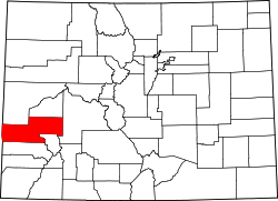
Paradox Valley is a basin located in western Montrose County in the U.S. state of Colorado. The dry, sparsely populated valley is named after the apparently paradoxical course of the Dolores River—instead of flowing down the length of the valley, the river cuts across the middle and through the sheer walls of large mesas on either side.[1] The valley is the site of a Bureau of Reclamation salinity-control project which has caused thousands of earthquakes,[2] and is the proposed location of a new uranium mill which would be the first built in the United States in over 25 years.[3]

Key Information

Geography and climate

[edit]

Paradox Valley trends northwest-southeast and measures about 3 to 5 miles (5 to 8 km) wide and 25 miles (40 km) long.[4] It lies along the extreme western edge of Colorado, close to the border with Utah, about 50 miles (80 km) south of the city of Grand Junction. The La Sal Range rises just to the northwest in Utah. State Highway 90 follows Paradox Valley on its way from Naturita to the Utah state line, crossing the Dolores River Bridge near the small unincorporated town of Bedrock. The town of Paradox lies a few miles north of the highway. Elevations on the valley floor range from about 5,000 feet (1,500 m) at the Dolores River to nearly 6,000 feet (1,800 m) at the southeast end. Steep parallel sandstone and shale[4] walls bound the valley to the northeast and southwest.

The valley was named in 1875 by geologist and surveyor Albert Charles Peale[1] after he noted that the Dolores River had a "desire to perform strange and unexpected things" in the area.[5] Instead of flowing down the valley's thalweg, the river emerges from a narrow gap in one wall, cuts perpendicularly across the mostly level valley floor, and exits through another gap in the opposite wall. As a consequence of this unusual geography, the valley cannot be easily irrigated by the Dolores River, but springs and streams fed by snowmelt from the La Sal Range support farming in the northwestern third of the valley.[6]

Near the center of the valley, the town of Bedrock experiences average highs ranging from 45 °F (7 °C) in December to 96 °F (36 °C) in July. Average lows range from 13 °F (−11 °C) in December to 54 °F (12 °C) in July. An average of 11 inches (28 cm) of precipitation, including 9 inches (23 cm) of snow, fall annually at Bedrock.[7]

Geology

[edit]
The entrenched Dolores River (lower right to upper left) is seen crossing Paradox Valley (center) in this simulated view
South end of the Paradox Valley
North end of the Paradox Valley

The apparent paradox of Paradox Valley can be explained by salt tectonics. The valley is a collapsed anticline, a type of geological fold. About 300 million years ago, during the middle Pennsylvanian period, when the Dolores River was already in existence, high pressures on lands to the northeast caused underlying salt deposits to flow towards where the valley is today. The salt encountered a buried fault-block ridge and was deflected upwards, penetrating the overlying rock strata and forming a salt dome. The salt may not have actually been exposed on the surface, but groundwater entering the top of the dome dissolved the underlying salt beds, allowing the center to collapse, forming what is today Paradox Valley. This process took place over about 150 million years, a long enough time for the Dolores River to downcut into the land and maintain its ancient course. The same process also created the Moab Valley (Spanish Valley) to the west, itself cut crosswise in a similar fashion by the Colorado River.[8]

The Paradox Formation, a geological formation containing salt, gypsum, anhydrite, shale, sandstone, and limestone,[9] is named after exposures found in Paradox Valley. The Paradox Basin, a geologic province throughout which the Paradox Formation is found, also bears the name of the valley.[8]

History

[edit]

Paradox Valley was within the historical domain of the Ute tribe.[10] An 1868 treaty created a reservation for the Utes over much of western Colorado, including Paradox Valley.[10] Squatters began grazing cattle in the valley as early as 1877, in violation of the treaty.[11] By 1881, the Utes had been forced out of the area, and in 1882 the United States Congress officially opened the land to settlement.[11] Springs and streams allowed farming in the northwest end of the valley, and the mid-1890s discovery of copper at the future site of the Cashin Mine near the town of Bedrock brought in a further influx of settlers.[12] The valley and the surrounding plateau soon also became an important source of radioactive materials, including radium and uranium. In 1913, The New York Times identified carnotite mines near Paradox Valley as the source of "the greatest radium ore deposits in the world".[13] Production of radium ceased in 1922 when richer deposits were found in the Belgian Congo, but production of uranium and vanadium continued throughout most of the century.[6]

Paradox Valley Unit

[edit]
Location of the injection well, brine production wells, and gauging stations

Near-surface salt beds up to 14,000 feet (4,300 m) thick still underlie Paradox Valley. The Dolores River, a tributary of the Colorado River, naturally picks up about 100,000[4]-200,000[14] tons of salt annually on its way through the valley.[4] In the 1980s, the United States Bureau of Reclamation began construction of a pumping facility known as the Paradox Valley Unit.[14] The PVU, a part of the wider Colorado River Basin Salinity Control Project, became fully operational in 1996 and collects saline groundwater from 12 shallow wells along the Dolores River. The system then dilutes the brine with water and a corrosion inhibitor and transports it to a high-pressure injection well, where it is deposited 14,000 to 16,000 feet (4,300 to 4,900 m) deep into Precambrian and Paleozoic rocks. A 2001 study found that the total salt reaching the Dolores had declined by about 90%, although this may have been the result of a period of low precipitation during the measurement period.[4] As of 2009, the PVU removes about 113,000 tons of salt annually from Paradox Valley.[14]

The injection well of the Paradox Valley Unit has induced thousands of earthquakes, including at least 4,000 prior to the year 2001.[15] Most were below the threshold of human detection, but at least 15 have been over 2.5 in magnitude, the largest being a 4.3 magnitude quake on May 27, 2000. The PVU suspended operations for 28 days following this quake, but later resumed injections at a lower rate.[2] Further earthquakes have been linked with the operation, including a 3.9 magnitude quake in 2004.[16]

Piñon Ridge Mill

[edit]

In 2009 Energy Fuels Resources Corporation, a subsidiary of Toronto-based Energy Fuels Incorporated, proposed the construction of a uranium mill in the southeast end of Paradox Valley.[3] Called the Piñon Ridge Mill, it would have been capable of processing 500 tons of uranium ore per day.[3] Legal action tied up the project for many years,[17] and as of September 2020 the project appears to have died.[18]

See also

[edit]

References

[edit]
[edit]
Revisions and contributorsEdit on WikipediaRead on Wikipedia
from Grokipedia
Paradox Valley is a collapsed salt anticline valley located in Montrose County, southwestern Colorado, United States, spanning approximately 25 miles in length and characterized by its ring of high sandstone mesas and the anomalous northward traversal of the Dolores River perpendicular to the regional geological grain.[1][2] The valley derives its name from this paradoxical river path, first noted in 1875 by USGS geologist Albert Charles Peale, who observed the Dolores River's unexpected course across the anticlinal structures rather than parallel to them.[3] Geologically, it forms part of the Paradox Basin, featuring the Paradox Formation—a sequence of Pennsylvanian-age evaporites including massive salt, gypsum, anhydrite, and interbedded shales, sandstones, and limestones—that drive unique salt tectonics and resource potential for hydrocarbons and minerals.[4][5] The valley's subsurface hydrology poses a significant natural challenge, as saline groundwater brines continually discharge into the Dolores River, contributing substantially to the Colorado River Basin's salinity load and impairing downstream water quality for agriculture and ecosystems.[6] To address this, the U.S. Bureau of Reclamation constructed the Paradox Valley Unit (PVU) in the 1990s, a pioneering salinity control facility that intercepts and extracts over 95,000 tons of salt annually from brine via a network of wells before injecting it deep underground, thereby preventing its entry into the river and fulfilling international obligations under the Colorado River Salinity Control Act.[6][7] This engineering intervention represents one of the most effective point-source salt reductions in the basin, though it has induced minor seismicity from high-pressure injections, prompting ongoing monitoring and operational adjustments.[2][8] Beyond resource extraction, including historical uranium mining in surrounding areas, Paradox Valley exemplifies causal interactions between evaporite dissolution, fluvial geomorphology, and human water management in arid environments.[9]

Geography

Location and Topography

Paradox Valley is situated in southwestern Colorado, primarily within Montrose County, at coordinates approximately 38°19′N 108°52′W.[10] It occupies the northeastern part of the Paradox Basin, an elongate structural depression trending northwest-southeast and extending from central-western Colorado into eastern Utah.[11] The valley measures about 24 miles (39 km) in length and 3 to 5 miles (4.8 to 8 km) in width, aligned along a northwest-southeast axis.[12] Elevations along the valley floor range from roughly 4,800 to 5,500 feet (1,463 to 1,676 m) above sea level.[13] The topography features a relatively flat basin floor dissected by the Dolores River, which traverses the valley transversely from southeast to northwest, creating a narrow floodplain amid surrounding steep escarpments.[12] These escarpments rise to form prominent mesas and plateaus capped by resistant Mesozoic sandstones, characteristic of the Colorado Plateau physiographic province.[5] The valley's linear form results from differential erosion of softer underlying strata relative to the harder overlying layers, producing a distinctive rectilinear drainage pattern and isolated buttes within the basin.[12]

Climate and Hydrology

Paradox Valley lies within a cold semi-arid climate zone (Köppen BSk), typical of the Colorado Plateau, with low annual precipitation averaging 15.83 inches (402 mm) distributed over about 118 days, primarily as summer convective storms and winter snowfall.[14] Mean annual temperatures fluctuate widely, with January averages featuring daily highs of 39.5°F (4.2°C) and lows of 17.4°F (-8.1°C), while July highs reach approximately 90°F (32°C).[15] [16] The region's elevation, around 5,447 feet (1,660 m), contributes to cold nights year-round and occasional freezing conditions even in summer.[17] Hydrologically, the valley is defined by the Dolores River, which traverses it longitudinally along the northern flank at elevations of 4,800-5,000 feet rather than incising the central axis, due to uplift from the underlying Paradox salt anticline preventing downcutting.[9] Average annual discharge at the Bedrock gauge, near the valley's eastern end, measures 299,400 acre-feet (369 million cubic meters), with high variability from snowmelt-driven peaks up to 715,800 acre-feet in wet years.[18] Natural salinity loading is elevated, stemming from groundwater dissolution of buried halite beds, which discharges brine seeps directly into the river and exacerbates downstream Colorado River salinity.[9] [6] To address this, the U.S. Bureau of Reclamation's Paradox Valley Unit, operational since 1996, extracts hypersaline groundwater via wells and injects it into deep subsurface formations, averting approximately 100,000 tons of salt annually from reaching the Dolores and achieving a 70% reduction in river salinity concentrations at Bedrock.[6] This intervention targets diffuse brine inflows identified across five major hydrogeologic units, underscoring the valley's unique coupling of structural geology and surface water quality.[9]

Geology

Stratigraphy and Formation

The stratigraphic sequence in Paradox Valley primarily encompasses Pennsylvanian to Permian sedimentary rocks of the Paradox Basin, overlying older Paleozoic carbonates and underlain by Precambrian basement in adjacent uplifts. The basal units include Mississippian Leadville Limestone and Devonian-Mississippian strata, transitioning upward into the Pennsylvanian Hermosa Group, where the Paradox Formation dominates as a thick evaporite sequence.[19] The Paradox Formation, Desmoinesian in age, comprises cyclic beds of halite (up to 85% of the section), anhydrite, gypsum, and potash salts (such as sylvite and carnallite), interbedded with organic-rich black shales, limestones, and minor sandstones; these cycles, numbering up to 29 in the basin, reflect repeated marine transgressions into a restricted, hypersaline depocenter with thicknesses exceeding 3,000 feet (900 meters) in subsiding areas.[20] [4] Overlying the Paradox Formation lies the Permian Honaker Trail Formation (upper Hermosa equivalent), consisting of interbedded carbonates, shales, and evaporites, succeeded by the Cutler Group red beds—arkosic sandstones, siltstones, and mudstones derived from erosion of the adjacent Uncompahgre uplift—capped in places by thin Triassic and Jurassic units.[19] [21] The Paradox Basin, encompassing Paradox Valley, originated in the late Pennsylvanian as an asymmetric, elongate northwest-southeast trending foreland depression (approximately 190 by 265 kilometers) along the southwestern flank of the basement-cored Uncompahgre uplift, driven by Ancestral Rocky Mountains tectonism.[22] Rapid flexural subsidence from Uncompahgre loading promoted thick accumulation of clastics and carbonates basinward, while restricted circulation in the sub-basin fostered evaporite precipitation through cyclic drawdown and refill, with halite mobility enhanced by high geothermal gradients and sediment overburden.[23] Paradox Valley specifically formed as a salt-cored anticline through reactive diapirism of the ductile Paradox salt layer, initiated during Permian loading and amplified by later Mesozoic-Cenozoic tectonics, wherein differential stress caused lateral flowage of the salt (behaving as a viscous fluid) to accommodate shortening and uplift, piercing overlying strata to create an elongate salt wall structure up to 5,000 feet (1,500 meters) thick.[2] This halokinesis, rather than purely sedimentary deposition, sculpted the valley's core, with salt dissolution at margins contributing to steep flanks and localized collapse features.[11]

Structural Features and the "Paradox" Phenomenon

Paradox Valley constitutes a collapsed salt anticline spanning approximately 23 miles (37 km) in length and averaging 3 miles (5 km) in width, oriented northwest-southeast within the Paradox Basin of western Colorado.[24] This structure arose from the diapiric rise of mobile salt layers forming a salt-cored anticline, followed by structural collapse driven by dissolution and downfaulting along bounding normal faults, including elements of the northwest-trending Wray Mesa fault system.[2] The valley's margins feature steep escarpments of resistant Mesozoic sandstones and shales overlying the Pennsylvanian-age Paradox Formation, which dominates the subsurface and exhibits ductile flow properties akin to a viscous fluid due to its composition of up to 85% halite interspersed with anhydrite, potash, gypsum, and minor clastics.[2][25] Halokinetic tectonics in the region, influenced by proximity to the Uncompahgre uplift, promoted salt mobilization and anticlinal buckling during the Pennsylvanian-Permian, with subsequent dissolution at shallow depths (less than 500 feet) eroding the salt core and inducing subsidence that deepened the valley floor under a veneer of Quaternary alluvium and colluvium.[2] The Paradox Formation's evaporitic cycles, deposited in a restricted basin, provided the thick salt section essential for this collapse, with overlying caprock layers of gypsum and anhydrite (several hundred feet thick) locally preserving structure but fracturing to permit groundwater incursions.[25] Northeast-trending strike-slip faults in the Precambrian basement further modulate the stress field, contributing to the valley's complex fault architecture observable in induced seismicity patterns.[2] The "paradox" phenomenon manifests in the hydrology of the Dolores River, which enters the valley perpendicular to its trend near Bedrock and traverses roughly northward, only to lose substantial surface flow through infiltration into the highly permeable alluvial fill (moderately to highly transmissive gravels exceeding 100 feet in thickness) overlying active dissolution zones.[25] This infiltration exploits karstic features—sinkholes, cavities, and conduits—formed by ongoing salt dissolution at the interface between caprock and halite, converting infiltrating freshwater into dense brine (total dissolved solids concentrations around 193,000 mg/L, with sodium at 70,600 mg/L and chloride at 110,000 mg/L) that migrates subsurface and reemerges via springs and seeps, particularly over a concentrated 4-mile reach.[25] Consequently, the river appears to "disappear" mid-valley without exiting at the northern end as a proportional surface stream, instead contributing up to 200,000 tons of salt annually to downstream waters via these brine discharges, exacerbating salinity in the Colorado River system absent mitigation efforts.[6][25] This causal interplay of structural collapse, evaporite solubility, and high-permeability valley fill underscores the valley's namesake anomaly, distinct from typical fluvial incision in non-evaporitic terrains.[2]

History

Early Exploration and Naming

The Paradox Valley region formed part of the traditional territory of the Ute people, who occupied much of western Colorado and utilized the area for hunting, gathering, and seasonal habitation prior to significant non-native incursion.[26] Spanish expeditions represented the earliest recorded European forays into southwestern Colorado, with Juan María Antonio Rivera traversing parts of present-day Montrose County in 1765 to assess mineral potential and Indigenous relations, followed by the Domínguez–Escalante expedition of 1776, which mapped routes through the broader region en route to seeking a path to California missions. However, no contemporary accounts confirm entry into the remote Paradox Valley itself, which remained largely undocumented by Europeans until the mid-19th century.[27][28] The first systematic non-native exploration and naming of Paradox Valley occurred during a U.S. Geological Survey expedition in 1875, led by geologist Albert Charles Peale, who was examining coal fields and geological structures in the area. Peale coined the name "Paradox" to describe the anomalous behavior of the Dolores River, which flows southward into the valley's southern end before turning northward along its length and abruptly sinking into underground sinkholes at the northern terminus, rather than exiting to join the Colorado River as topographic gradients might suggest. In his field notes, compiled in the Ninth Annual Report of the U.S. Geological Survey, Peale observed that the river exhibited a "desire to perform strange and unexpected things," highlighting the counterintuitive hydrology driven by karst dissolution of underlying Paradox Formation salt layers.[29][30] This designation captured the valley's structural oddity as a collapsed salt anticline, where evaporite tectonics had warped drainage patterns, though Peale's initial assessment predated full comprehension of these subsurface processes.[2]

Settlement and Early Resource Use

Settlement in Paradox Valley began in the late 1870s amid Ute tribal lands designated as a reservation by the 1868 treaty. Euro-American ranchers, including Thomas Goshorn and Riley Watson, established operations there in 1877, preceding the Ute removal to Utah in 1881.[26] Following the removal, additional settlers arrived, drawn by opportunities for grazing on the valley's open ranges, leading to the formation of a small ranching community known as Paradox.[26] Early resource use centered on cattle ranching, which suited the valley's semi-arid grasslands and sparse vegetation. Herds were ranged extensively across the area, supporting a subsistence economy for settlers before infrastructure development.[26] Limited irrigated farming occurred along the Dolores River, producing hay and vegetables for local consumption, though water scarcity constrained larger-scale agriculture.[27] Prospecting for minerals marked the onset of extractive activities in the 1890s. In 1895, the discovery of copper deposits near Paradox, including the Cashin mine, triggered a brief influx of miners and temporary economic growth in the ranching-dominated region.[26] These efforts yielded modest output, with ore processed locally or shipped out, but did not sustain long-term booms until later mineral explorations.[27]

Mid-20th Century Uranium Boom

In the aftermath of World War II, the U.S. Atomic Energy Commission (AEC) initiated a uranium purchasing program in 1948 to secure domestic supplies for nuclear weapons development, sparking a prospecting rush across the Colorado Plateau, including the Paradox Valley region in southwestern Colorado.[31] This demand transformed earlier vanadium and radium extraction sites, such as those near Uravan adjacent to Paradox Valley, into major uranium operations, where carnotite ores containing uranium-vanadium deposits were targeted using portable Geiger counters by independent prospectors and companies.[32] The Uravan Mineral Belt, encompassing Paradox Valley, saw intensified mining activity from the late 1940s, with the U.S. Vanadium Corporation expanding its facilities to process uranium ore as a primary product alongside vanadium for steel alloying.[33] By the early 1950s, southwestern Colorado's uranium output surged under federal incentives, with firms investing in underground mines and mills to meet AEC contracts guaranteeing markets at fixed prices.[31] In the Paradox Basin area, deposits in the Salt Wash Member of the Morrison Formation yielded significant ore, contributing to Colorado's production of over 100 million pounds of U3O8 equivalent by the 1960s, much of it from the Uravan district's roll-front deposits formed by groundwater leaching and precipitation.[34] Uravan's mill, operational since the 1930s for vanadium, processed thousands of tons of ore annually during peak years, employing hundreds in a company town that peaked at around 800 residents by the mid-1950s, supported by fenced government stockpiles for Manhattan Project legacies and Cold War needs.[35] The boom peaked between 1952 and 1957, driven by Cold War escalation, but began waning by the late 1950s as AEC purchases declined with sufficient stockpiles and cheaper imports, leading to mine closures and economic contraction in Paradox Valley by the early 1960s.[31] Despite the temporary prosperity, operations relied on low labor costs and overlooked health risks from radon exposure, with production figures reflecting episodic booms tied to geopolitical demands rather than sustained geology alone.[36]

Resource Management and Extraction

Paradox Valley Unit: Salinity Control Operations

The Paradox Valley Unit (PVU), operated by the U.S. Bureau of Reclamation as part of the Colorado River Basin Salinity Control Program, intercepts highly saline groundwater discharging into the Dolores River to prevent salt loading into the Colorado River system.[6] Brine collection occurs via nine shallow production wells aligned along the Dolores River in Paradox Valley, Montrose County, Colorado, where groundwater salinity exceeds 300,000 milligrams per liter.[1] The extracted brine is pumped to a surface treatment facility for processing before injection into deep subsurface formations.[6] Deep-well injection disposes of the treated brine into a limestone formation at depths of approximately 14,100 to 15,750 feet, isolating it from surface waters and reducing evaporative concentration.[37] Operations commenced in July 1996 with an initial injection well, supplemented by additional wells to manage increasing volumes and pressures.[37] The system includes monitoring for injection pressures, seismic activity, and groundwater quality to ensure containment and compliance with Underground Injection Control regulations.[38] Surface facilities encompass evaporation ponds for residual water management and infrastructure for brine transport over a 16-mile pipeline.[39] Since inception, the PVU has prevented an average of 95,000 to 100,000 tons of salt annually from entering the Colorado River Basin, accounting for roughly 10% of the program's total salinity reductions. By 2016, cumulative salt removal reached 2.2 million tons, yielding economic benefits estimated at $70 per ton in avoided damages to downstream agriculture and infrastructure.[8] Effectiveness is quantified through pre- and post-operation monitoring, showing a substantial decline in Dolores River dissolved solids near Bedrock, Colorado, from baseline levels.[40] In response to induced seismicity linked to injection pressures, operations scaled back in 2022 to a rate of 115 gallons per minute, representing 67% of historical levels.[6] This adjustment yielded 62,913 tons of salt removed in 2024, an increase from 53,257 tons in 2023, while ongoing evaluations assess long-term viability and alternatives.[6] Maintenance includes daily oversight, repairs, and seismic monitoring to mitigate risks without halting salinity interception.[41]

Uranium and Vanadium Deposits

The uranium and vanadium deposits of Paradox Valley, located within the broader Uravan mineral belt of the Colorado Plateau, are hosted predominantly in the Salt Wash Member of the Jurassic Morrison Formation, a sequence of fluvial sandstones and mudstones. These deposits form as tabular, lenticular ore bodies through the mobilization of uranium and vanadium from volcanic ash sources via oxidizing groundwaters, followed by precipitation in reducing conditions within permeable sandstone channels, often associated with carbonaceous material or sulfides. The primary ore mineral is carnotite (K₂(UO₂)₂(VO₄)₂·3H₂O), a secondary vanadate that imparts a characteristic yellow staining, accompanied by tyuyamunite, meta-tyuyamunite, and coffinite as uranium phases, with vanadium silicates and oxides like montroseite in some zones.[42][43][44] Prospectors identified the yellow carnotite-bearing outcrops in Paradox Valley's rim rocks prior to 1880, though initial exploitation focused on associated copper minerals. By 1900, mining commenced at the Cashin mine in the valley, where vanadium extraction from carnotite ores supported early steel alloy production, yielding grades typically between 1-2% V₂O₅ and 0.1-0.3% U₃O₈ in high-grade zones. Deposits are stratigraphically controlled, with ore thicknesses averaging 1-3 meters and lateral extents up to hundreds of meters, but economic concentrations are irregular due to the epigenetic, roll-front style of mineralization.[45][44][45] Historical production from Paradox Valley and adjacent areas contributed significantly to U.S. vanadium supply during World War I for armor plating and, later, to uranium output post-1940s, with the region's ores comprising a substantial portion of the Colorado Plateau's total, which accounted for 70% of domestic uranium and 98% of vanadium by 1964. Remaining identified resources in the Paradox Basin, including valley-adjacent prospects, are estimated at tens of millions of pounds of recoverable U₃O₈ equivalent, though extraction faces challenges from low grades (often below 0.2% U₃O₈) and environmental remediation requirements.[46]

Piñon Ridge Mill Development

The Piñon Ridge Mill was proposed by Energy Fuels Resources Corporation, a subsidiary of Toronto-based Energy Fuels Inc., as a conventional uranium and vanadium processing facility capable of handling up to 500 short tons of ore per day on average.[47] The project, approved by Energy Fuels' board of directors in May 2007, involved acquiring approximately 1,000 acres of land west of Naturita in Paradox Valley, Montrose County, Colorado, with initial site work commencing shortly thereafter.[48] Construction plans included a mill, tailings impoundment, and evaporation pond for managing process wastewater, aimed at processing ore from regional deposits amid rising uranium demand between 2004 and 2007.[49] Permitting efforts advanced through multiple regulatory hurdles, culminating in a preliminary radioactive materials license from the Colorado Department of Public Health and Environment (CDPHE) in early January 2011, followed by final approval on January 5, 2011, marking the first such U.S. license for a new uranium mill in nearly 30 years.[50] [47] The CDPHE license addressed radiation safety and operational limits, while separate approvals were sought for tailings disposal under U.S. EPA Title II standards and county land-use permits.[51] However, Montrose County land-use approvals, granted in 2009 after hearings, faced ongoing litigation from environmental groups citing risks to air quality, water, and wildlife near the San Miguel River.[52] [53] Development stalled due to protracted legal challenges, including a 2018 CDPHE administrative law judge ruling that revoked license renewal for failure to adequately protect local flora, fauna, and avian species from contamination risks.[54] Energy Fuels subsequently sold the license and property in an effort to streamline operations amid declining uranium prices and regulatory delays, transferring it to a private investor group led by Baobab Asset Management.[55] As of August 2025, Western Uranium & Vanadium Corp. has prioritized reactivation of the site for in-house yellowcake production, though no construction has occurred and full permitting remains unresolved.[56] The project's history reflects tensions between domestic mineral supply needs and environmental safeguards, with opponents highlighting legacy contamination from prior Paradox Valley mining while proponents emphasize modern containment technologies.[57][58]

Environmental Impacts and Risks

Induced Seismicity from Brine Injection

The Paradox Valley Unit (PVU), operated by the U.S. Bureau of Reclamation, injects highly saline groundwater extracted from shallow wells into a deep disposal well to prevent salt loading into the Dolores River, a tributary of the Colorado River. Injection operations commenced in January 1991 at Salinity Control Well No. 1, which reaches a depth of approximately 4,880 meters (16,000 feet), targeting fractured crystalline basement rock. The process elevates pore pressure in the subsurface, reducing effective stress on faults and triggering slip along preexisting fractures, thereby inducing seismic events.[6][59] Seismic monitoring began in 1983 with the establishment of the Paradox Valley Seismic Network (PVSN), which expanded to 15 stations by the early 1990s to track microseismicity. Since injection started, over 5,900 earthquakes have been recorded, with magnitudes ranging from below detection limits to a maximum of 4.5 on August 1, 2000, near the Utah-Colorado border. Most events are shallow (less than 8.5 km deep) and clustered around the injection well, with hypocenters delineating fault structures in the Precambrian basement. Analysis of event patterns indicates a correlation between injection volume and seismicity rates, including swarms following high-pressure pulses.[2][60][61] Cumulative injection volumes exceeding 100 million barrels by 2011 have led to pressure buildup, prompting operational adjustments such as cyclic injection and rate reductions to mitigate larger events. For instance, after the 2000 M4.5 quake, injection pressures were lowered, temporarily reducing event frequency. In 2021, the PVSN detected 356 earthquakes, with 353 attributed to injection, though magnitudes remained below 3.0. Modeling studies forecast potential for events up to M5.5 under continued high-volume injection without further constraints, based on fault dimensions and stress changes inferred from relocated hypocenters.[62][63][64] While no significant structural damage has been reported, felt events have raised concerns among local residents and prompted environmental impact assessments. The U.S. Geological Survey and Bureau of Reclamation continue to refine pressure-flow models integrating seismic data to predict and manage risks, emphasizing that induced seismicity here provides a natural laboratory for understanding fluid-injection hazards in low-permeability formations. Peer-reviewed analyses confirm the causal link via spatiotemporal alignment of events with injection logs, distinguishing induced activity from natural background seismicity in the tectonically quiet region.[59][65][66]

Legacy Effects of Mining Activities

The Uravan mining district, located within the Paradox Valley region of southwestern Colorado, processed over 10 million tons of uranium- and vanadium-bearing ores from the 1920s through the mid-1980s, generating extensive radioactive tailings, waste raffinate, and contaminated residues that persist as primary legacy contaminants.[67] These include radium-226, thorium, heavy metals such as lead, arsenic, cadmium, and vanadium, as well as radon gas emissions from ore decay.[68] Tailings piles and processing residues contaminated approximately 400 acres of soil and groundwater, with seepage affecting riverbanks along the San Miguel River and underlying aquifers.[67] Beyond the Uravan mill site, hundreds of abandoned uranium mines in the surrounding Paradox Valley wilderness, largely inactive since the 1970s, continue to leach radioactive particles and radon into local waterways, including Horn Creek—a tributary feeding the Dolores and Colorado Rivers.[69] This has rendered portions of aquifers unusable and contributed to elevated radioactivity in surface waters historically used for agriculture and livestock.[57] Statewide, legacy tailings from nine defunct Colorado uranium mills, including those tied to Paradox Valley operations, total around 20 million tons, with contamination extending to heavy metal and radionuclide pollution in rivers like the Colorado.[57] Remediation efforts at Uravan, designated a Superfund site, involved relocating 3 million cubic yards of waste to secure, double-lined repositories, capping 10 million cubic yards of tailings in disposal cells, demolishing over 300 contaminated structures, and treating 245 million gallons of groundwater, completed by 2004 at a cost of $127 million.[67] Broader Colorado cleanups for similar sites have exceeded $1 billion, with specific Paradox-area expenditures including $120 million at Uravan and ongoing annual monitoring costs of approximately $1 million shared between state and federal agencies.[57] These actions have stabilized major sources, but full reclamation of dispersed abandoned mines remains underfunded and fragmented, with no comprehensive cost estimates for addressing radon releases or groundwater plumes.[69] Current risks are mitigated by the evacuation of Uravan township and non-potable status of affected aquifers, posing no immediate human health threats, though long-term surveillance by the U.S. Department of Energy is required for residual contaminants expected to persist for centuries.[68] Environmental persistence includes managed groundwater plumes under sites like Club Ranch Ponds and potential wind dispersion of dust from unreclaimed areas, necessitating indefinite institutional controls to prevent exposure or migration.[67]

Controversies and Policy Debates

Debates Over Salinity Control Alternatives

The primary salinity control method at the Paradox Valley Unit (PVU), operational since 1996, involves extracting hypersaline groundwater from wells along the Dolores River and injecting it into a deep subsurface formation at depths exceeding 15,000 feet to isolate it from surface waters.[6] This approach intercepts approximately 100,000 tons of salt annually, accounting for roughly 10% of basin-wide salinity reductions in the Colorado River, thereby mitigating downstream impacts on irrigation efficiency, crop yields, and infrastructure corrosion. However, induced seismicity from injection pressures, which has escalated since 2016 with earthquakes up to magnitude 4.1 and damaged the primary injection well by 2019, has prompted debates over alternatives, as documented in the U.S. Bureau of Reclamation's 2019 Environmental Impact Statement (EIS).[70][71] Key alternatives evaluated include constructing evaporation ponds to concentrate and solidify brine via solar evaporation, zero-liquid-discharge (ZLD) technologies involving advanced crystallization, and drilling new injection wells in alternative formations.[72] Evaporation ponds were historically considered in the 1970s but rejected due to requirements for over 2,000 acres of land, potential for salt dust emissions affecting air quality, risks of brine seepage contaminating local aquifers, and hazards to wildlife from open hypersaline pools; a pilot study confirmed these drawbacks while estimating annual operational costs exceeding $20 million.[73][74] ZLD systems, which aim to recover water and crystallize salts without liquid waste, face scalability challenges for the PVU's 90,000 acre-feet of brine volume, with high energy demands (potentially 10-15 kWh per cubic meter) and capital costs projected at $500 million or more, rendering them uneconomical without subsidies.[72] New injection wells, proposed in variants like capping the existing well and drilling offset bores, risk replicating seismicity if hydraulic fracturing or fault activation occurs, as evidenced by modeling of subsurface pressures.[75] The "no-action" alternative—discontinuing operations—has been selected in the 2020 Record of Decision, prioritizing short-term cost savings and seismic risk avoidance over salinity control, though operations persist at reduced rates (about 30% capacity as of 2024) pending further evaluation.[72][76] Downstream stakeholders, including Lower Basin water agencies, oppose this due to projected salinity increases of 10-15 mg/L in the Colorado River, equating to $5-10 million in annual agricultural losses from reduced water usability, as quantified in basin salinity models.[77] Environmental advocates favor non-injection options to eliminate quake risks but criticize evaporation for land and dust issues, while federal assessments emphasize injection's historical efficiency (costing ~$0.50 per ton of salt removed versus $2-5 for ponds).[74][78] Ongoing research into hybrid or emerging technologies, such as deep-well alternatives with real-time pressure monitoring, reflects unresolved tensions between water quality benefits and localized geologic hazards.[6]

Opposition to Uranium Processing Facilities

Local environmental and conservation groups, including the Sheep Mountain Alliance, Rocky Mountain Wild, and the Sierra Club, have spearheaded opposition to the Piñon Ridge uranium mill proposed for Paradox Valley in Montrose County, Colorado, primarily citing risks of radioactive contamination and ecological disruption from ore processing and tailings storage.[50][54] These organizations contended that the mill's operations would generate tailings impoundments vulnerable to groundwater infiltration, potentially contaminating aquifers in the Dolores River watershed, while wind could disperse radioactive dust affecting air quality and nearby communities in Montrose, Mesa, and San Miguel counties.[79][80] Public input reflected widespread resident concerns, with dozens submitting formal comments against the project during licensing hearings, highlighting proximity to fault lines that could exacerbate seismic risks from waste disposal and threaten water supplies already strained in the arid region.[54][81] Grassroots coalitions, such as the Paradox Valley Sustainability Association, further argued that the mill endangered tourism-dependent economies and organic agriculture by undermining perceptions of environmental safety, prioritizing short-term mining jobs over long-term sustainable development.[82][83] Legal challenges intensified opposition, with Sheep Mountain Alliance filing lawsuits against county special-use permits and state licenses, alleging inadequate hazardous waste management and procedural flaws.[84] In April 2018, Administrative Law Judge Richard W. Dana recommended denial of Energy Fuels' radioactive materials license after evidentiary hearings, finding insufficient demonstrations of protection against wildlife harm, plant toxicity, and airborne radionuclide spread; the Colorado Department of Public Health and Environment revoked the license on April 26, 2018.[80][54] Economic analyses commissioned by opponents, such as a 2017 report by consultant Tom Power, projected minimal net job gains and potential tourism losses exceeding mining benefits, reinforcing claims that the facility's risks outweighed its contributions to domestic uranium supply.[79] Protests and advocacy persisted post-revocation, with groups like the Western Mining Action Project continuing to monitor revival attempts, emphasizing legacy contamination from prior Paradox Valley mining as evidence of unmitigated hazards.[85] Despite county approvals of land-use permits in prior years amid divided public opinion, sustained litigation and regulatory scrutiny have delayed operations, reflecting broader tensions between resource extraction and watershed preservation in the Colorado Plateau.[83][86]

Economic and Strategic Significance

Contributions to Water Quality and Agriculture

The Paradox Valley Unit (PVU) intercepts highly saline groundwater inflows in Paradox Valley, preventing an estimated 100,000 tons of salt from annually dissolving into the Dolores River and reaching the Colorado River system.[87] This brine extraction and deep-well injection process has cumulatively removed over 2.2 million tons of salt since operations began in 1996, accounting for roughly 10% of the total salinity reductions achieved basin-wide under the Colorado River Basin Salinity Control Program.[8][87] By maintaining salinity levels below numeric criteria established in interstate agreements—such as 723 mg/L downstream of Hoover Dam—the PVU directly enhances river water quality for municipal, industrial, and agricultural uses across seven U.S. states and Mexico.[88] Lower salinity mitigates total dissolved solids (TDS) buildup, which otherwise corrodes infrastructure, elevates treatment costs for potable water, and impairs irrigation efficiency.[6] For agriculture, the dominant consumptive use in the Colorado River Basin, PVU contributions reduce salt-induced yield reductions in crops by up to 20-30% for sensitive varieties like beans and lettuce, while preserving soil permeability and minimizing leaching requirements that demand excess water application.[89] In the Lower Basin, where irrigated lands span millions of acres in Arizona and California, these improvements avert annual economic losses estimated at $382 million across U.S. users from salinity-related damages, with agriculture bearing the majority through foregone productivity and heightened drainage expenses.[90] The PVU's targeted salt diversion thus sustains viable farming of staples such as alfalfa, cotton, and citrus, supporting regional food production without expanding water allocations.[89] Quantified benefits from PVU operations include up to $23 million in annual value from optimized water usability, primarily via agricultural productivity gains and reduced energy demands for desalinization in irrigation systems.[64] These outcomes align with broader program evaluations crediting salinity controls with $26 per ton of salt prevented, underscoring the PVU's cost-effectiveness despite localized operational challenges.[91] Continued functionality remains critical, as unchecked natural salt loading from Paradox Valley alone historically contributed 205,000 tons yearly to the Dolores River, exacerbating downstream constraints under fixed water deliveries mandated by the 1922 Colorado River Compact.[92]

Role in Domestic Energy Supply

The uranium deposits in Paradox Valley, part of the broader Paradox Basin in western Colorado, have historically supported the U.S. nuclear fuel cycle. From the 1940s through the 1980s, mining operations in the area, including the Uravan mill, processed ore into concentrates that fueled early atomic weapons development under the Manhattan Project and subsequent civilian nuclear reactors, contributing to national energy and defense needs during a period when domestic sources dominated supply.[93][32] Contemporary mining near Paradox Valley bolsters limited domestic uranium output amid high import dependence. In 2025, Western Uranium & Vanadium Corp. operates the Sunday Mine Complex in adjacent San Miguel County, extracting ore for shipment to Energy Fuels Inc.'s White Mesa Mill in Utah, where it is milled into U3O8 yellowcake—the form used for nuclear reactor fuel. This activity forms part of the U.S.'s 2024 domestic production of 677,000 pounds U3O8, equivalent to roughly 0.2% of annual reactor requirements, as over 90% of fuel is imported from countries including Kazakhstan and Canada.[56][94][95] Development of processing infrastructure at the former Piñon Ridge Mill site in Paradox Valley holds potential to amplify contributions to energy security. Licensed for 500 tons of ore per day (expandable to 1,000 tons), the facility—now rebranded by Western Uranium as the Mustang Mineral Processing Plant—could enable local conversion to yellowcake, reducing transportation costs and supporting expanded output from regional deposits estimated at tens of millions of pounds U3O8. Prioritization of this site aligns with policy pushes for domestic sourcing to mitigate supply risks in nuclear power, which provides about 19% of U.S. electricity with minimal carbon emissions.[96][97][98]

References

User Avatar
No comments yet.