
Community hub
Recent from talks
Contribute something
Nothing was collected or created yet.
Ruggles Mine
View on Wikipedia
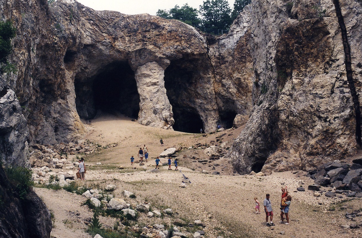
Ruggles Mine is an open-pit mine that was turned into a tourist attraction. It was closed but was recently[when?] sold and has reopened.[1] The mine is located 40 miles (64 km) northwest of Concord, New Hampshire, in the town of Grafton, a short distance from Route 4 at the village green. The spacious pit includes tunnels and underground chambers, some of which are filled with water. Visitors are allowed to keep any of the various minerals that they find on the mine floor or that can be hammered loose from the walls of the pit.[2][3]
Key Information


Geology
[edit]The mineral deposits found in the area, known as the Littleton Formation, date from the Devonian period and have been estimated by geologists to be roughly 350 million to 400 million years old. Over 150 minerals have been discovered at the mine, mica being the most prevalent, but also including feldspar, beryl, amethyst, rose/smoky quartz, and garnet.[4] Specimens of the rare uranium minerals, such as uranophane, torbernite, and autunite, have been found.[5]
History
[edit]Sam Ruggles (3 August 1770 – 27 May 1843) started the first commercial mica mine in the United States at the site that bears his name. Mica at the time was used to make, among other things, lamp chimneys and stove windows. Ruggles began as a grocer and was merchant of West India goods in Boston, Massachusetts. He was never a resident of New Hampshire (he was born, lived and died in Boston), and hired local workers in Grafton to operate the mine. Local lore states that the mine was started in 1803, but there is no documented evidence that supports the claim. Ruggles' first purchase of property on Isinglass Hill in Grafton was on 5 July 1805. He made subsequent purchases of adjoining properties in 1806 and 1810. His first advertisement for mica ("sheet isinglass") appeared in the Boston Semi-Weekly Advertiser on 9 November 1825. By 1831 his occupation was listed in the Boston Directory as a merchant of sheet isinglass. He had a storefront and warehouse in Boston where he sold mica.
Sam Ruggles sold his mine properties to his son George Haskell Ruggles (1802 – 6 May 1863) in 1834. Sam's son Charles (1809 – 13 April 1869) worked as clerk and bookkeeper for his father and brother. Sam and George managed the business together until Sam's death in 1843, after which George continued the family business on his own. After George's death in 1863, Joseph D. Gould (Sam Ruggles' nephew) was appointed trustee of the estate and managed the mica business until he was removed as trustee by Sam Ruggles' heirs in 1879. Sam Ruggles' grandsons George H., Charles L. and Samuel H. Randall (by Sam's daughter Sarah Ann and Henry Randall) ran the business until 1896 when it was abandoned amid bankruptcy and litigation.[6]
The operation grew over the years—by 1869, more than 26,000 pounds (12,000 kg) a year of mica was being extracted from the mine. The value of the mica mined at Ruggles was estimated to be about $12 million by the 1960s, by which time there were new applications for the mineral in cosmetics, cement block, asphalt roofing, and electrical insulators in appliances such as GE brand toasters.[4] Beginning in 1912, mining began for feldspar, which was used as a nonabrasive scour in the production of china glazes. Later on beryl was also mined.
In 1960, the mine was put up for sale. It was purchased that winter by the Wahlstrom family,[3] who bought it for its well-deserved reputation for top-quality mica. Soon thereafter, however, cheaper sources of mica from foreign suppliers became available and domestic demand correspondingly dropped. The Wahlstrom family decided to turn the mine into a tourist attraction, and in 1963 Ruggles Mine opened to the public.
Current status
[edit]
The mine was open to the public from mid-May to mid-October from 1963 through 2015.[7] The mine was closed in 2016 and put up for sale by its owners.[8] In 2018 an online petition was started by a local resident to turn the mine into a New Hampshire state park. The New Hampshire State Park Advisory Council was exploring the issue.[9]
In September 2019, the Searles family, who had bought the mine more than a half century earlier, sold it to Exciglow LLC, which was described as being "affiliated with a production company."[1]
On July 19, 2023, the mine was sold to Joe Bodge, from New Hampshire.[10]
As of June 21, 2024, the mine was reopened to the public under the new ownership.
To reach the mine, the drive up Isinglass Mountain is steep and over meandering back roads. At the top of the mountain, visitors are greeted by a panoramic view stretching for miles. After paying admission and gaining entrance, visitors walk down a steep descent into the mine. Visitors are allowed to keep the minerals that they find, up to a 5 gallon bucket, per person.
References
[edit]- ^ a b "Valley News - Grafton's Ruggles Mine changes hands".
- ^ Review Team. "Ruggles Mine (In Transition)". Roadside America. Retrieved July 5, 2016.
- ^ a b "Tuesday June 26: Digging for treasure at Ruggles Mine". WMUR. 27 June 2012. Retrieved July 5, 2016.
- ^ a b Don Wickman. "Outdoors: Dig Through Time at Ruggles Mine". Kearsarge Magazine. Retrieved July 5, 2016.
- ^ "Mineral Information and Links". Ruggles Mine. Retrieved July 5, 2016.
- ^ Davis, F. E. (2013) U.S. Mica Industry Pioneers: The Ruggles and Bowers Families. Amazon.com
- ^ "Fruitautomaten Online Spelen Voor Echt Geld – De Fruitautomaat Top 10".
- ^ Kristen Carosa (May 18, 2016). "Ruggles Mine up for sale after decades as tourist attraction". WMUR. Retrieved July 5, 2016.
- ^ Ramer, Holly (16 July 2018). "New Hampshire explores turning Ruggles Mine into state park". WMUR-TV. Manchester. Retrieved 17 July 2018.
- ^ "Two NH residents buy Ruggles Mine in Grafton". New Hampshire Public Radio. 2023-07-24. Retrieved 2024-08-09.
External links
[edit]- Official website
- Former website for Ruggles Mine (archived 2016)
- Ruggles Mine photos at pbase.com
- "Outdoors: Dig through Time at Ruggles Mine". Don Wickman, Kearsarge Magazine
Ruggles Mine
View on GrokipediaLocation and Description
Geographical Location
Ruggles Mine is situated in the town of Grafton, Grafton County, New Hampshire, United States, at coordinates 43°35'26"N 71°59'27"W.[2] The site occupies a 235-acre parcel atop Isinglass Mountain, an elevation rising to approximately 1,810 feet (551 meters) above sea level in the White Mountains region.[8][7] Access to the mine is via a steep, meandering road off New Hampshire Route 4, near the Village Green in Grafton, leading to the address 286 Underhill Road, Grafton, NH 03240.[9][10] The location places Ruggles Mine about 30 miles northwest of Concord and roughly 100 miles north of Boston, within a rural area characterized by forested hills and scenic vistas.[10][11] Known locally as the "Mine in the Sky," the open-pit quarry sits on the southeast slope of Isinglass Mountain, offering panoramic views of the surrounding New Hampshire countryside upon ascent.[9] The site's elevated position contributes to its appeal as a former mining operation now repurposed for tourism and rockhounding.[11]Physical Features
Ruggles Mine is an open-pit mica quarry situated on the southeast slope of Isinglass Mountain in Grafton, New Hampshire, characterized by a rugged, mountainous terrain that facilitates hiking and exploration. The primary excavation is a spacious open pit measuring approximately 368 feet in length, with varying widths of 153 feet at the northeast end, 113 feet at its narrowest waist, and 134 feet at the southwest end; the pit reaches a depth of up to 140 feet in places, exposing layered pegmatite formations.[4] The site's topography slopes downward from northeast to southwest, with early mining workings concentrated at lower elevations and later operations higher up, where waste material was dumped into older cuts to create leveled areas such as the current parking lot and overlook.[4] The mine features a network of underground tunnels and chambers, including the Northeast Entrance Tunnel, which was extended in the late 1950s to early 1960s from a blind drift and now connects directly to the parking area, and the Southwest Exit Tunnel, part of the 140-foot level known as Stope #2. These passages, some partially filled with water, branch off from the main pit and include stopes such as Stope #1—an open cut with a 25-foot-high room and raised stope that remains off-limits—and Stope #2, which expanded to over 400 feet in width by 1944. A notable stone arch structure spans between the tunnel exits, while remnants of a concrete mill building lie west of the main workings.[4][12] Historically, the pit evolved through the merger of smaller excavations, including Pit A (initially 115 by 75 feet, expanded to engulf Pit B by 1941), Pit C (expanded from 37 by 36 feet to 53 by 71 feet), and Pit D (grown from 39 by 59 feet to 93 by 120 feet by 1944), forming the current large open cut. The overall layout, as mapped in 1938 by E.L. Shaub, includes 5-foot elevation contours and cross-sections revealing a complex pegmatite body up to 300 feet wide at higher elevations. Today, the site's physical features support recreational mineral collecting across loose gravel areas and newly exposed sections, with trails winding through the quarry's irregular contours and water features.[4][9]Geology
Geological Context
Ruggles Mine is situated in the Grafton pegmatite district of west-central New Hampshire, part of the broader New England pegmatite belt that extends across the region. The mine occupies the southeastern slope of Isinglass Mountain in Grafton, Grafton County, where it intrudes into metamorphic rocks of the Devonian Littleton Formation. This formation consists primarily of quartz-mica schist, sillimanite-mica schist, biotite gneiss, and amphibolite, with the pegmatite body located a short distance east of the hangingwall contact of the Devonian Bethlehem pluton. The surrounding geology reflects the Acadian orogeny, involving intense folding, faulting, and metamorphism during the Late Devonian, which predates pegmatite emplacement.[13][14][3] The Ruggles pegmatite formed during the Carboniferous period, approximately 300 to 330 million years ago, as a late-stage magmatic intrusion associated with the crystallization of nearby granitic bodies such as the Concord granite or Bethlehem gneiss. These pegmatites are interpreted as fractionated melts derived from the partial melting of crustal rocks during post-orogenic magmatism, injecting discordantly into the foliation of the host schists and gneisses. The deposit belongs to the New Hampshire magma series, characterized by lithium- and beryllium-enriched compositions that facilitated the concentration of rare elements. Uranium-lead dating of uraninite crystals from the mine supports an age of around 302 to 329 million years, aligning with the broader timing of pegmatite formation in the region.[13][3][15] Structurally, the Ruggles pegmatite manifests as an irregular, lens-shaped body that strikes approximately N. 35° E and plunges doubly to the northeast and southwest. It measures up to 1,640 feet along strike, with a maximum width of 335 feet and thickness of 160 feet, though exposures vary due to mining and erosion. The body exhibits classic zoning typical of granitic pegmatites: a fine-grained aplitic border zone (0.5–4 inches thick) of quartz, plagioclase, and muscovite transitions into a wall zone (1–7 feet thick) rich in plagioclase, perthite, quartz, and muscovite. Interior zones include mica-rich intermediate layers, a biotite-tourmaline-bearing zone, massive perthite feldspar cores up to 120 feet thick, and discontinuous quartz pods or cores. Replacement features, such as scrap-mica bodies and tourmalinized schist inclusions, indicate metasomatic interactions between the pegmatite and host rocks during emplacement. This zoning reflects sequential crystallization from the margins inward, with volatile-rich fluids driving differentiation and mineral segregation.[13][14][3]Mineralogy
The Ruggles Mine is situated within a complex, zoned pegmatite body of the lithium-cesium-tantalum (LCT) family, emplaced in the Devonian Littleton Formation schists near the contact with the Bethlehem Gneiss. This pegmatite, striking N. 35° E and reaching up to 1,640 feet in length and 335 feet in width, exhibits internal zoning that controls mineral distribution, with wall zones rich in muscovite and graphic intergrowths transitioning to core areas dominated by massive quartz and perthitic feldspar. Over 48 mineral species have been identified, reflecting fractional crystallization processes that concentrated rare elements like lithium, beryllium, niobium, tantalum, and uranium.[2][14][3] The primary economic minerals include muscovite and feldspars. Muscovite, occurring as light yellowish-green books up to several inches across in sheet-mica zones, constitutes 50-75% of certain aggregates and was the chief product from 1803 onward, valued for its electrical insulating properties. Feldspars dominate the central zones: perthite (microcline-perthite intergrowths) forms massive lenses up to 450 feet long and 60 feet wide, mined for ceramics and abrasives like Bon Ami scouring powder; plagioclase (albite to oligoclase, An₀-An₅) appears platy as cleavelandite in border and replacement zones; and microcline occurs coarsely in quartz-rich cores. Quartz, gray to smoky in massive bodies up to 15 feet thick, often hosts these feldspars and serves as a gangue mineral. Beryl (Be₃Al₂Si₆O₁₈), green hexagonal crystals up to several inches, is a notable byproduct concentrated near pegmatite centers in quartz lenses, with minor production for beryllium extraction.[3][14][2] Accessory and rare minerals highlight the pegmatite's geochemical evolution. Black schorl tourmaline (NaFe₃Al₆Si₆O₁₈(BO₃)₃(OH)₃(OH)) is abundant in biotite and wall zones, often forming radiating sprays. Phosphate minerals such as triphylite (LiFePO₄) and lithiophilite (LiMnPO₄) occur in lithium-enriched pockets with cleavelandite, while fluorapatite (Ca₅(PO₄)₃F) forms hexagonal crystals intergrown with micas. Uranium-bearing species, including uraninite (UO₂) and its alteration product gummite (a mixture of U oxides and hydrates), are localized in the No. 1 feldspar zone, with secondary phases like autunite (Ca(UO₂)₂(PO₄)₂·10-12H₂O) and uranophane (Ca(UO₂)₂(SiO₃OH)₂·5H₂O) forming fluorescent crusts; these were prospected intermittently from the 1930s. Other gems and rarities include chrysoberyl (BeAl₂O₄), topaz (Al₂SiO₄(F,OH)₂), and zircon (ZrSiO₄), found in scattered crystals within quartz cores.[2][3][14]| Mineral | Chemical Formula | Occurrence and Significance |
|---|---|---|
| Muscovite | KAl₂(AlSi₃O₁₀)(OH)₂ | Sheet-mica zones; primary economic mineral for insulation.[3] |
| Perthite (Microcline) | K(AlSi₃O₈) with Na(AlSi₃O₈) lamellae | Core lenses; mined for feldspar in ceramics.[14] |
| Beryl | Be₃Al₂(Si₆O₁₈) | Quartz cores; byproduct for beryllium.[3] |
| Uraninite | UO₂ | No. 1 zone; source of uranium minerals.[2] |
| Triphylite | LiFePO₄ | Lithium pockets; indicates LCT fractionation.[3] |