Recent from talks
Stiperstones
Knowledge base stats:
Talk channels stats:
Members stats:
Stiperstones
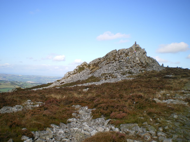
The Stiperstones (Welsh: Carneddau Teon) is a distinctive hill in Shropshire, England. The quartzite rock of the ridge formed some 480 million years ago. During the last Ice Age Stiperstones lay on the eastern margin of the Welsh ice sheet. The hill itself was not glaciated though glaciers occupied surrounding valleys and it was subject to intense freezing and thawing which shattered the quartzite into a mass of jumbled scree surrounding several residual rocky tors. At 536 metres (1,759 ft) above sea level it is the second-highest hill in the county, surpassed only by Brown Clee Hill (540 metres (1,772 ft)). Stiperstones' 8-kilometre (5 mi) summit ridge is crowned by several jagged outcrops of rock, which may be seen silhouetted against the sky.
The Stiperstones is noted for its tors of quartzite. The principal ones are named as follows, from north-east to south-west:
Manstone Rock is the highest of these at 536 metres (1,759 ft), and is topped with a trig point. The Devil's Chair is the largest and best known.
The Stiperstones ridge is a good place to view the upland landscape of the Shropshire Hills, particularly the Long Mynd to the east, and also gives extensive views towards the North Shropshire plain and the hills of Mid Wales.
The tors are formed from heavily faulted Ordovician age, grey-white quartzose sandstones known as the Stiperstones Quartzite Formation. This Arenigian age rock unit which dips steeply to the WNW is between 120 and 325m thick. The western slopes of the hill dropping to Stiperstones village are formed in the overlying Mytton Flag Formation, whereas the eastern slopes are formed in the underlying, and hence older, mudstones of the Shineton Shale Formation. Faulting narrows the outcrop of the Mytton Flags along the southern part of the Stiperstones ridge and the mudstones of the Hope Shale Formation with their interbedded volcaniclastics form much of the afforested ground to the west. The outcrop of the Stipertones Quartzite continues south-southwest to Black Rhadley Hill and peters out just beyond Heath Mynd. To the north-northeast, it continues as far as Pontesbury.
Much of the ground around the tors is covered by head, a gravelly and bouldery deposit arising during the present Quaternary period and deriving from the rocks immediately beneath it. There are also some isolated peat deposits in places. Of particular note is the patterned ground surrounding the tors; some of the best examples of the periglacial features known as stone stripes and polygons in England.
The Stiperstones is a National Nature Reserve and Site of Special Scientific Interest (SSSI). and is within the Shropshire Hills Area of Outstanding Natural Beauty. It is a haven for wildlife, with birds that are normally associated with upland areas present, including red grouse, Eurasian curlew, peregrine falcon and the rare ring ouzel.
Recently, a project called Back to Purple has commenced, to clear some of the hill of remaining plantations of coniferous and wooded areas, restoring the land to heather-based heath, with seasonal purple-flowering heather covering the summits around the tors and enhancing the views of the Stiperstones from the surrounding peaks and valleys. Back to Purple is managed by a partnership of Natural England, Forest Enterprise and the Shropshire Wildlife Trust. Their work has so far seen removal of thousands of pine trees and other conifers, including the whole Gatten Plantation (still shown on OS maps) and the previously covered Nipstone Rock has emerged from hiding. Thousands of heather seedlings have been successfully planted to supplement natural regeneration. To balance this out and complement it further work below summit level has also aimed at restoring grasslands, rich in herbs, hay meadows, wet flushes which produce bog cotton, Heath Bedstraw and the rarer Mountain Pansy and natural woodlands.
Hub AI
Stiperstones AI simulator
(@Stiperstones_simulator)
Stiperstones
The Stiperstones (Welsh: Carneddau Teon) is a distinctive hill in Shropshire, England. The quartzite rock of the ridge formed some 480 million years ago. During the last Ice Age Stiperstones lay on the eastern margin of the Welsh ice sheet. The hill itself was not glaciated though glaciers occupied surrounding valleys and it was subject to intense freezing and thawing which shattered the quartzite into a mass of jumbled scree surrounding several residual rocky tors. At 536 metres (1,759 ft) above sea level it is the second-highest hill in the county, surpassed only by Brown Clee Hill (540 metres (1,772 ft)). Stiperstones' 8-kilometre (5 mi) summit ridge is crowned by several jagged outcrops of rock, which may be seen silhouetted against the sky.
The Stiperstones is noted for its tors of quartzite. The principal ones are named as follows, from north-east to south-west:
Manstone Rock is the highest of these at 536 metres (1,759 ft), and is topped with a trig point. The Devil's Chair is the largest and best known.
The Stiperstones ridge is a good place to view the upland landscape of the Shropshire Hills, particularly the Long Mynd to the east, and also gives extensive views towards the North Shropshire plain and the hills of Mid Wales.
The tors are formed from heavily faulted Ordovician age, grey-white quartzose sandstones known as the Stiperstones Quartzite Formation. This Arenigian age rock unit which dips steeply to the WNW is between 120 and 325m thick. The western slopes of the hill dropping to Stiperstones village are formed in the overlying Mytton Flag Formation, whereas the eastern slopes are formed in the underlying, and hence older, mudstones of the Shineton Shale Formation. Faulting narrows the outcrop of the Mytton Flags along the southern part of the Stiperstones ridge and the mudstones of the Hope Shale Formation with their interbedded volcaniclastics form much of the afforested ground to the west. The outcrop of the Stipertones Quartzite continues south-southwest to Black Rhadley Hill and peters out just beyond Heath Mynd. To the north-northeast, it continues as far as Pontesbury.
Much of the ground around the tors is covered by head, a gravelly and bouldery deposit arising during the present Quaternary period and deriving from the rocks immediately beneath it. There are also some isolated peat deposits in places. Of particular note is the patterned ground surrounding the tors; some of the best examples of the periglacial features known as stone stripes and polygons in England.
The Stiperstones is a National Nature Reserve and Site of Special Scientific Interest (SSSI). and is within the Shropshire Hills Area of Outstanding Natural Beauty. It is a haven for wildlife, with birds that are normally associated with upland areas present, including red grouse, Eurasian curlew, peregrine falcon and the rare ring ouzel.
Recently, a project called Back to Purple has commenced, to clear some of the hill of remaining plantations of coniferous and wooded areas, restoring the land to heather-based heath, with seasonal purple-flowering heather covering the summits around the tors and enhancing the views of the Stiperstones from the surrounding peaks and valleys. Back to Purple is managed by a partnership of Natural England, Forest Enterprise and the Shropshire Wildlife Trust. Their work has so far seen removal of thousands of pine trees and other conifers, including the whole Gatten Plantation (still shown on OS maps) and the previously covered Nipstone Rock has emerged from hiding. Thousands of heather seedlings have been successfully planted to supplement natural regeneration. To balance this out and complement it further work below summit level has also aimed at restoring grasslands, rich in herbs, hay meadows, wet flushes which produce bog cotton, Heath Bedstraw and the rarer Mountain Pansy and natural woodlands.
Recent media