Hubbry Logo
Stockton LakeStockton LakeMain
Open search
Stockton Lake
Community hub
Stockton Lake
logo
8 pages, 0 posts
0 subscribers
Be the first to start a discussion here.
Stockton Lake
Stockton Lake
from Wikipedia

Stockton Lake is a reservoir located in southeastern Cedar County, northeastern Dade County, and southwestern Polk County, Missouri. The lake is V-shaped, and covers 39 square miles (100 km2), with 298 miles (480 km) of shoreline. It has three marinas, and 10 public-use areas. It has a "non-development policy," and is surrounded by unspoiled, tree-covered hills. Its banks are owned and operated by the Army Corps of Engineers.

Key Information

Boaters anchored together enjoying a day on Stockton Lake.

Stockton Lake is one of Missouri's seven major lakes, all man-made. It was formed by damming the Sac River near the city of Stockton in 1969. The lake is crossed by three state highways over a network of six bridges. A pipeline carries water from Stockton Lake to Fellows Lake in northern Greene County to help supplement water for the city of Springfield. Stockton lake has numerous coves protected from the wind making it a great lake to wakeboard, water ski or other water sports.

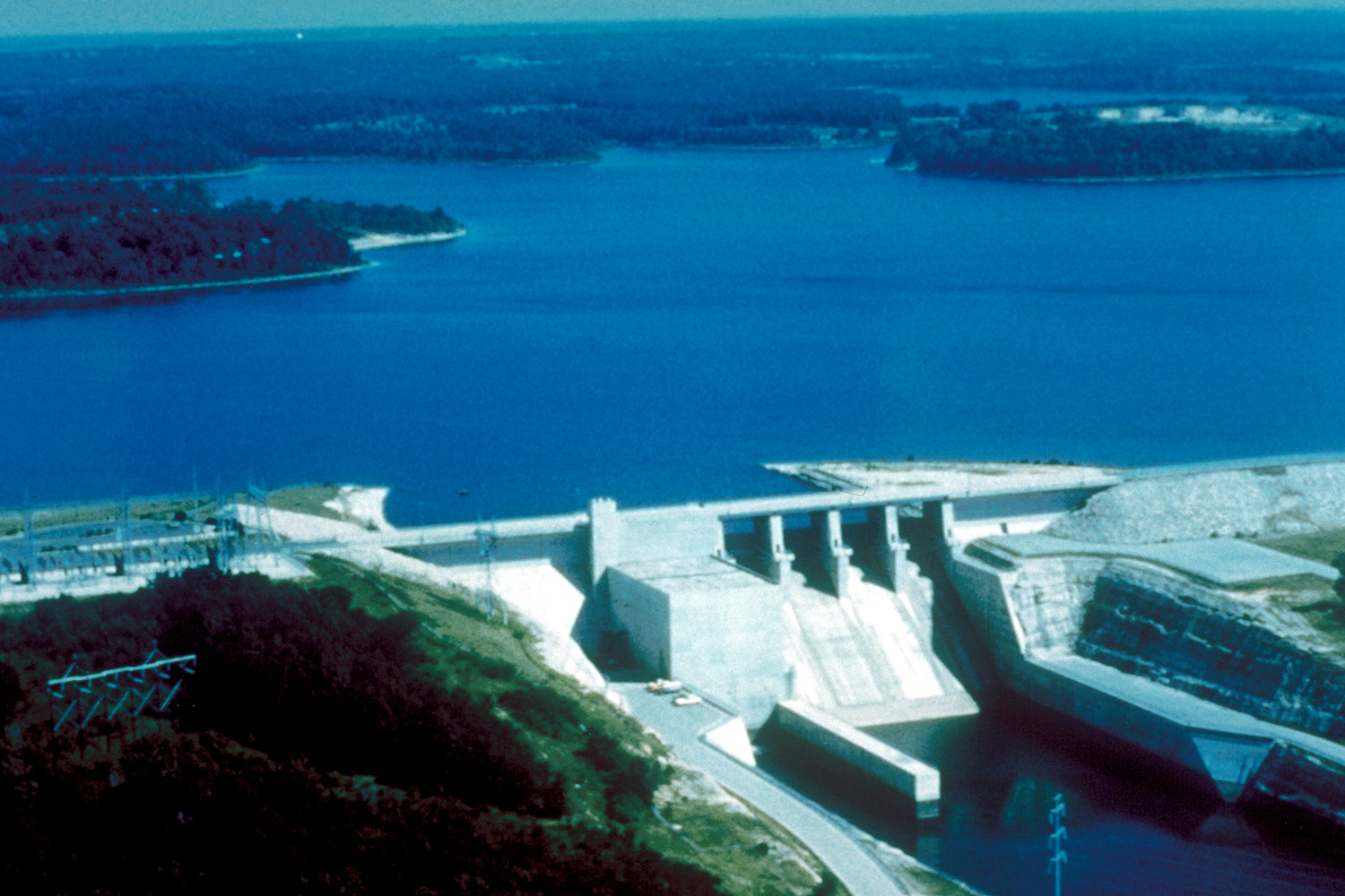
Stockton Dam and hydroelectric power plant

[edit]

After the USACE construction was complete on the 5,100-foot (1,600 m) dam, the lake began filling in 1969.[1][2] The dam rises 153 feet (47 m) above the Sac River streambed.[1] The lake is about 24,900 acres (10,100 ha) with 298 miles (480 km) of shoreline. Normal pool is at 867 feet (264 m) above mean sea level (msl) with storage of 875,000 acre-feet (1.079×10⁹ m3).[1] The flood storage capacity of the lake is 1,674,000 acre-feet (2.065×10⁹ m3) of water at an elevation of 892 feet (272 m) msl, during which the surface area of the reservoir grows to 63,200 acres (25,600 ha). Stockton Lake is operated primarily for flood control and hydroelectric generation and originally had an installed capacity of 45.2 MW in a single electric generator.[1][3]

The original powerhouse of the dam had a single 280-inch (7.112 m) six-bladed Kaplan turbine designed by Newport News Shipbuilding and Dry Dock Company and a General Electric generator rated at 45.2 MW.[4] The original turbine was placed in service in 1973.[5] After years of heavy vibration and a poorly matched turbine design, one of the blades catastrophically failed in February 2009, causing an immediate shutdown of the plant.[6] The sheared off blade, weighing 9,000 pounds (4,100 kg), was later recovered from the river.[4][5][7] The turbine runner was repaired in 2010 by welding the old blade back in place. Other cracks were also discovered and repaired at this time.[4]

While the repaired turbine was operating, the Corps of Engineers and contractors tried to determine how to correct the issues at Stockton Dam. Analysis concluded that the original turbine was likely rated for a much different site due to its ability to spin at nearly full power without tilting the blades past their "full flat" setting.[4] Why the turbine and generator were mismatched has not been determined. Due to the significant issues and age of the turbine, an entirely new one was custom designed for replacement in 2014-2015. Upgrades for the $48 million project include:

  • The new 71,700-horsepower Kaplan turbine runner,[4] with 7 bolt on blades (rather than 6),[5] 75 rpm
  • rewiring the generator windings of the rotor and stator
  • electrical rating increase to 52 MW[5][7]
  • new digital excitation system, surface air coolers, and digital governor for the generator
  • refurbishment of the mechanical accessories
  • 161 kV main power transformer replacement
  • Intake gate and draft tube bulkhead repairs
  • Salvage and in-place blade repair
  • emergency diesel generator replacement
  • asbestos abatement and lead paint removal.[4]

The Stockton Power Plant is a peaking plant that produces 55 GWh of average annual energy valued at $8.3 million.[4][5] The new, more efficient turbine was installed in 2014[5] and became operational in January 2015.[6] Part of the costs of the repair were offset by the American Recovery and Reinvestment Act. The old turbine was placed on a pedestal above the road which crosses the dam.[5]

Stockton Equestrian Trail

[edit]

Stockton Lake features an equestrian trail that is approximately 15 miles long and travels in close proximity along the lake shore from Hawker Point to Orleans Trail Campgrounds.[8] This is a multi use trail for Hikers and Mountain biking, there are no motorized vehicles allowed.

Sailing at Stockton

[edit]
Sailing is a very popular activity at Stockton Lake.

The great sailing conditions are fueled by winds from Oklahoma and Kansas, consistently blowing from west to east across the lake. About one-third of the 300 mile lake is accessible to sailboats, the bridges across the lake on Highway 215 and 245 prevent most sail boats from going farther on the lake, but this section of lake is still an ideal location for sailing. The Stockton Yacht club holds annual races on the lake that usually draw large numbers of boats, with the most prestigious of these races being the Governor's Cup Regatta.

References

[edit]
[edit]
Revisions and contributorsEdit on WikipediaRead on Wikipedia
from Grokipedia
Stockton Lake is a 24,900-acre reservoir in southwestern Missouri, spanning Cedar, Dade, and Polk counties approximately 50 miles northwest of Springfield, formed by the impoundment of the Sac River via a dam constructed by the U.S. Army Corps of Engineers and completed in 1969. The lake serves multiple purposes as part of the Corps' network for managing the Missouri and Mississippi River basins, including flood damage reduction for downstream areas, hydroelectric power generation marketed through the Southwestern Power Administration, water supply storage for entities like City Utilities of Springfield, Missouri (including a 2025 allocation providing an additional 38 million gallons per day as of March 2025), and enhancements to fish and wildlife management, downstream water quality, and navigation flows. The project encompasses 61,000 acres of combined land and water under Corps management, with 16,572 acres leased to the Missouri Department of Conservation for additional conservation efforts. Recreation is a cornerstone of Stockton Lake's role, drawing visitors to its clear waters and surrounding Ozark Plateau landscape for activities such as , , , , , , , , and wildlife viewing. The lake supports robust fisheries, managed jointly by the Corps and Missouri Department of Conservation, with notable populations of (good prospects in 2025, with over half exceeding 10 inches), (excellent, with 83% over 15 inches due to annual stocking since 2011), , , and , aided by more than 500 fish attractors. Facilities like provide boat launches, a swimming beach, campsites, and cabins, making it a key destination in the region.

Geography and Hydrology

Location and Formation

Stockton Lake is situated in the southwestern part of , primarily in southeastern Cedar County, with portions extending into northeastern Dade County and southwestern Polk County. The reservoir is centered at approximately 37°41′N 93°46′W, encompassing a diverse landscape shaped by the region's geology and hydrology. The lake was formed through the impoundment of the Sac River, a significant tributary of the Osage River, which ultimately drains into the Basin. Construction of the Stockton Dam in the late 1960s created this reservoir as part of a broader federal initiative to manage in the . The Sac River originates in the Springfield Plateau and flows northward for about 118 miles before reaching the dam site, where it was harnessed to form the 24,900-acre lake. Positioned at the boundary between the Ozark Plateau to the south and the expansive prairie lands to the north, Stockton Lake occupies an ecological transition zone that blends forested hills with open grasslands. This location influences the lake's biodiversity, supporting a mix of Ozarkian woodlands and prairie-adapted species along its 298 miles of shoreline. Before the dam's completion, the Sac River exhibited highly variable flows, with average annual discharges around 500 cubic feet per second at the Stockton gauging station, but it was notoriously flood-prone due to intense seasonal rainfall and rapid runoff from its 1,160-square-mile drainage area. Major floods, such as those in 1943 and 1944, devastated downstream communities and farmlands, highlighting the need for control measures. These events directly contributed to the authorization of the Stockton project under the Flood Control Act of 1944, which aimed to reduce flood risks across the Osage River watershed.

Physical Characteristics

Stockton Lake covers a surface area of approximately 24,900 acres at its normal pool elevation of 867 feet above mean . The reservoir reaches a maximum depth of 110 feet near the and maintains an average depth of about 40 feet across its basin. Its shoreline extends over 298 miles, encompassing numerous coves, islands, and irregular contours that enhance its ecological and recreational diversity. The lake serves critical hydrological functions, primarily providing flood storage capacity of 780,000 acre-feet to mitigate downstream flooding in the Osage River basin. In 2025, the U.S. Army Corps of Engineers reallocated storage to increase yield, supplying via a dedicated to , with a capacity of up to 38 million gallons per day to support municipal and industrial needs. Additionally, regulated releases from the reservoir contribute to low-flow augmentation, aiding on the interconnected and systems. Formed by impounding the Sac River, the lake's water levels experience seasonal fluctuations, which are actively managed by the U.S. Army Corps of Engineers to balance these objectives. Water quality in Stockton Lake is generally clear, characterized by low attributable to its upland watershed with minimal sediment inputs from agricultural and forested lands. The U.S. Army Corps of Engineers monitors and maintains these conditions through operational protocols that minimize loading and preserve the reservoir's oligotrophic to mesotrophic status.

History

Pre-Construction

Prior to the construction of Stockton Dam, the region encompassing the future Stockton Lake along the Sac River in southwest was under the control of the Osage Indians until the early . The Osage, a Siouan-speaking people, dominated much of present-day , including the Sac River basin, where they established villages and utilized the fertile river valley for hunting and deer, fishing abundant species such as and bass, and facilitating trade networks with neighboring tribes and early European explorers. The 1808 Treaty of Fort Clark, signed between the Osage and the , ceded vast territories east of the , including the Sac River area, marking the beginning of their displacement westward and opening the region to increased non-Native incursion. European American settlement accelerated in the mid-19th century, transforming the Sac River valley into a hub for milling and agrarian activities. Caplinger Mills, established around 1849 in Cedar County by Samuel Caplinger, exemplifies this era; the community featured operational grist mills powered by the river, wooden bridges for wagon traffic, and small dams that harnessed water flow for grinding corn and wheat to support local farms. These structures not only bolstered the economic viability of early homesteaders but also fostered small trading posts and ferries, though many were later partially submerged by the lake or relocated for preservation, such as remnants of the historic now maintained as a state historic site. Entering the 20th century, Cedar County's economy centered on agriculture, with family-operated farms producing corn, livestock, and dairy products amid a landscape of small towns like Stockton and El Dorado Springs. This rural character persisted, but the Sac River's propensity for flooding posed recurrent threats, as documented in major events such as the July 1909 crest reaching 29.3 feet and 92,000 cubic feet per second, which inundated lowlands and damaged mills and croplands, and the more devastating May 1943 flood peaking at 31.8 feet and 120,000 cubic feet per second, exacerbating erosion and agricultural losses in the basin. The pre-construction era's cultural significance is underscored by archaeological surveys conducted in the and early , which uncovered over 90 sites and 24 isolated prehistoric artifacts across the proposed reservoir area, including Osage-era tools, pottery, and projectile points indicative of long-term Native American occupation, alongside pioneer-era relics such as mill components and homestead foundations. These findings, systematically recorded by the U.S. Army Corps of Engineers, revealed a layered history of indigenous sustenance practices and adaptation to the riverine environment.

Construction and Development

The Stockton Lake project was authorized by the U.S. Congress through the Flood Control Act of 1954, which empowered the U.S. Army Corps of Engineers to construct a dam and hydroelectric generator on the Sac River near , as part of a broader multi-purpose initiative encompassing flood control, power generation, water supply, and recreation. The Kansas City District of the Corps led the planning and design, emphasizing integrated resource management to address recurring floods in the Osage River basin while supporting regional . Construction commenced in 1963, with the Amis Construction Company of , , awarded the primary contract for the dam; a formal occurred in 1964 following initial site preparations and land acquisitions. The project progressed through the mid-1960s, involving extensive earthwork, placement, and rerouting, culminating in the closure of the dam's gates on December 12, 1969, which initiated reservoir filling. Full operational completion and official dedication followed later that year, marking the lake's readiness for its intended purposes under Corps management. The total cost of the project reached approximately $80 million—originally estimated at $40 million—reflecting the scale of engineering required to manage 25,000 acres of surface and over 60,000 acres of surrounding , including the relocation of highways, utilities, and several communities to accommodate inundation. Immediate impacts included the displacement of numerous farms, homes, and businesses in the Sac River valley, with graves relocated and historic structures either moved or submerged, fundamentally altering local landscapes and pre-existing settlements. Since its inception, the reservoir has prevented an estimated $320 million in downstream flood damages, underscoring its enduring value in hazard mitigation.

Infrastructure

Stockton Dam

The Stockton Dam is an earth-fill embankment structure designed for multi-purpose water management, primarily flood control, with a hydraulic height of 153 feet and a length of 5,100 feet along the main embankment. Its crest sits at an elevation of 911.4 feet above mean sea level, providing structural integrity against high water loads. The dam features a gated spillway equipped with four tainter gates (each 40 feet wide by 30.5 feet high) for controlled overflow and auxiliary outlet works consisting of intake structures and two 12-foot diameter conduits for low-level releases. Construction employed compacted earth and rock for the embankment body, reinforced with concrete elements in the spillway and outlet components, all founded on stable rock to ensure long-term stability and seepage control. The impervious core and zoned fill design minimize internal erosion risks, with the foundation supporting the full load of the structure. Operationally, the dam regulates Stockton Lake levels to mitigate downstream flooding along the Sac and Osage Rivers, storing floodwaters up to 18 feet above the normal conservation pool elevation of 867 feet through phased pool management. During high inflow events, water is released via the gates or outlet works to augment downstream flows, maintaining channel capacities and reducing peak discharges in the basin. Guide curves dictate release rates based on inflow, pool rise, and forecast conditions to balance storage and conveyance. Maintenance responsibilities fall under the U.S. Army Corps of Engineers, which conducts annual visual inspections, biennial comprehensive evaluations, and periodic instrumentation monitoring for settlement, seepage, and structural integrity. Risk-informed assessments, including seismic and hydrologic reviews, ensure compliance with federal dam safety standards; the structure has experienced no major failures since impoundment began in 1969.

Hydroelectric Power Plant

The hydroelectric power plant at Stockton Dam is an integral component of the overall dam structure, designed to harness the energy from water releases for . The facility features a single vertical-axis Kaplan turbine-generator unit that came online in 1973, with an original installed capacity of 45.2 megawatts (MW). This run-of-river system operates by directing water through the turbine during controlled releases from the , converting hydraulic energy into electrical power without significant upstream storage for peaking beyond daily demand cycles. The plant's power output is marketed and transmitted by the Southwestern Power Administration (SWPA), a federal agency under the U.S. Department of Energy responsible for delivering renewable from multiple U.S. of Engineers projects. In peaking operations, fluctuates daily to meet regional demand, with real-time schedules and data publicly available through SWPA's online resources and hotline. The average annual production is estimated at 55,000 megawatt-hours (MWh), sufficient to power approximately 5,000 average U.S. households, though actual output varies based on water availability and operational priorities like flood control. To enhance and reliability, the facility has undergone targeted modernizations. In 2009, following a , the U.S. Army Corps of Engineers invested $33.5 million in American Recovery and Reinvestment Act (ARRA) funds for repairs, including replacement, refurbishment, transformer upgrades, and generator rewinding, minimizing downtime and environmental impacts from discharges. Further improvements occurred in 2014 with the installation of a new featuring an additional , increasing the capacity to 52 MW while reducing usage per megawatt generated by about 16 percent, thereby improving overall without altering the run-of-river . These upgrades ensure the plant continues to provide clean, low-impact as part of the broader Osage River Basin network.

Ecology and Environment

Aquatic and Terrestrial Ecosystems

Stockton Lake functions as a mesotrophic , characterized by moderate nutrient levels and clear water with an average transparency of 2.4 meters, supporting a productive yet balanced . The lake's waters host diverse communities, including indicated by chlorophyll a concentrations that reflect good algal productivity without excessive blooms, alongside occasional low-level occurrences of . Submerged aquatic vegetation, such as coontail () and watermilfoil ( spp.), thrives in shallower areas, providing habitat and contributing to the for and . These habitats extend to include four permanent streams, ephemeral pools, springs, and man-made ponds within the management lands, fostering a range of aquatic microenvironments. The terrestrial ecosystems surrounding Stockton Lake encompass approximately 61,000 acres of public land, representing a transitional zone between the forested Ozark Plateau and the western Missouri prairies. Dominant vegetation includes oak-hickory forests covering much of the rolling hills, interspersed with native prairie grasslands, old fields, and small wetland areas comprising less than 1% of the managed acreage. These diverse zones, including glades and savannas, support a mosaic of habitats that buffer the shoreline and contribute to overall landscape connectivity, with riparian corridors featuring native woody species to stabilize stream banks. Water quality in Stockton Lake is maintained through ongoing monitoring of nutrients and sediments from its 1,160-square-mile watershed in the Sac River Basin, where total phosphorus and nitrogen levels remain below state and ecoregion thresholds, preventing eutrophication. Invasive species pose challenges, with efforts focused on preventing and controlling zebra mussels (Dreissena polymorpha), which have been detected in nearby Corps of Engineers watersheds and threaten to alter native mussel communities and water clarity. As of 2025, zebra mussels remain absent from Stockton Lake but are monitored closely due to their presence in nearby reservoirs, with the Missouri Department of Conservation emphasizing boat inspections to prevent introduction. Asian carp species, such as silver and bighead carp, are monitored as potential invaders in the region, with management strategies including boat inspections and targeted removal to protect the ecosystem; no established populations have been reported in Stockton Lake as of 2025. These interventions, combined with riparian restoration, help sustain habitat integrity across both aquatic and terrestrial realms. Biodiversity at Stockton Lake is notable, particularly among avian species, with over 100 bird species documented in the area, including wintering bald eagles (Haliaeetus leucocephalus) that frequent the open waters and shorelines. Amphibians and reptiles find suitable refugia in the lake's coves, rocky shorelines, and adjacent wetlands, benefiting from the varied microhabitats formed by streams and forested edges. This rich assemblage underscores the lake's role as a key ecological hub in the Ozarks-prairie transition.

Wildlife Management and Conservation

The Missouri Department of Conservation (MDC) plays a central role in at Stockton Lake, annually stocking fingerlings measuring 1-2 inches to support the population and enhance opportunities. The lake is renowned for its trophy , with fish commonly reaching 15 inches within two years of stocking, contributing to excellent prospects. In collaboration with the U.S. Army Corps of Engineers (USACE), MDC maintains over 500 fish attractors to bolster habitat for species including bass and , while enforcing creel limits and length regulations such as a 15-inch minimum for largemouth and , a 12-inch minimum for , and a 10-inch minimum for with a daily limit of 15. Terrestrial conservation efforts focus on the 16,572 acres surrounding the lake leased by USACE to MDC for habitat management and public use. These lands feature a mix of grasslands, timbered areas, glades, and old fields, where MDC employs practices such as timber management, grassland restoration, and maintenance of old fields to support small game species like and rabbits. Prescribed burns are utilized as a key tool to restore and maintain these habitats, reducing risk while promoting native vegetation beneficial to wildlife. The lake's ecosystems provide habitat for protected species, including the endangered and , which rely on forested riparian zones and woodlands for roosting and foraging. nesting success serves as an indicator of improving , with active nests reflecting a healthy environment. Partnerships between USACE and MDC ensure coordinated management, including the lease of lands for conservation and the installation of fish habitat structures. Public access areas allow and under statewide regulations, with exceptions such as annual approvals for deer and , while foraging activities like mushroom collection follow general MDC guidelines to protect resources.

Recreation and Tourism

Water-Based Activities

Stockton Lake provides diverse boating opportunities, supported by multiple public boat ramps and full-service accessible year-round. The U.S. Army Corps of Engineers maintains at least nine public boat ramps, including those at Cedar Ridge, Crabtree Cove, Hawker Point, High Point, and Mutton Creek, facilitating easy launches for motorized and non-motorized vessels. such as Stockton Marina and Orleans Trail Marina offer rentals including pontoon boats, boats, kayaks, and canoes, along with fuel, slips, and repair services. No-wake zones in protected coves, like Mutton Creek Cove, ensure safer navigation for smaller craft and paddlers. Fishing at Stockton Lake is available year-round, attracting anglers with its abundant populations of , , , , , and . Spring typically marks peak crappie activity as fish move into shallower coves and brushy structures, while fall sees heightened catches along the dam and river channels due to cooling waters. The Missouri Department of Conservation stocks annually, contributing to strong populations that support both recreational and tournament fishing. Events such as those hosted by American Bass Anglers and Missouri Bass Nation draw competitors, highlighting the lake's reputation for quality bass and fisheries. Swimming and diving are popular at designated beaches and underwater sites around the lake. Stockton features a gravel beach suitable for swimming, while the U.S. Army Corps of Engineers designates five safe swimming areas, including Orleans Trail Beach and Cedar Ridge Beach, monitored for . opportunities exist in the lake's deeper channels, reaching up to 100 feet, though visibility generally ranges from 5 to 10 feet depending on conditions and location. Paddlers can explore the 6.65-mile Stockton Water Trail, which hugs over five miles of shoreline and offers scenic views of forested bluffs and , with trailheads at the and Hartley Cove for easy access. Sailing thrives on Stockton Lake due to its consistent winds and expansive 25,000-acre surface, earning it recognition as one of the top 10 lakes in the United States. Prevailing breezes of 10 to 20 , often from the or west, provide ideal conditions for both novice and experienced sailors. The Lake Stockton organizes annual regattas, including the Governor's Cup and Gumbo Cup, fostering a vibrant community. instruction is available through American Sailing Association-certified programs at Lake Stockton Boat Works, located near the , offering courses for beginners and advanced racers.

Land-Based Activities

Stockton State Park provides a variety of options, including over 70 campsites divided between the East and West campgrounds, with electric and water hookups available at many sites, modern restrooms, hot showers, and laundry facilities. The park also features seven log cabins and nine duplex units equipped with full kitchens, , and , suitable for families or small groups, as well as two special-use primitive camping areas for groups requiring reservations. Beyond the state park, the U.S. Army Corps of Engineers (USACE) manages several designated campgrounds around the lake, such as Cedar Ridge and Ruark Bluff East, offering a combined total of over 350 sites with electric hookups, dump stations, and shower houses, though dispersed camping on USACE lands typically requires permits and is limited to established areas. The lake's shoreline supports extensive trail networks for and biking, with Stockton alone featuring more than five miles of paths, including the moderate 8-mile Lakeview Trail that winds through woodlands and offers scenic overlooks of the water. is permitted on designated multi-use trails within the park, such as sections of the Umber Ridge Trail, a 1.6-mile loop suitable for intermediate riders navigating forested terrain. Equestrian activities are prominent on the 15-mile Stockton Lake Equestrian Trail, which connects Hawker Point and Orleans Trail campgrounds, traversing forests, prairies, and open lands managed for multi-use recreation. Picnicking areas are abundant, with two reservable shelters in —one overlooking the lake with and —equipped with grills and tables for gatherings. Wildlife viewing opportunities enhance these sites, particularly for , as overlooks and interpretive trails like Nyblad Trail highlight local species such as bald eagles and great blue herons amid the surrounding bottomland forests and uplands. Additional land-based pursuits include on park-designated paths, as noted earlier, and seasonal on USACE and Department of Conservation management lands, where opportunities target during archery and firearms seasons, as well as in spring and fall, subject to statewide regulations and permits.

References

Add your contribution
Related Hubs
User Avatar
No comments yet.