

Community hub
Recent from talks
Contribute something
Nothing was collected or created yet.
New Taipei City
View on WikipediaKey Information

.jpg)

.jpeg)


| New Taipei City | |||||||||||||||||||||||||||||||||
|---|---|---|---|---|---|---|---|---|---|---|---|---|---|---|---|---|---|---|---|---|---|---|---|---|---|---|---|---|---|---|---|---|---|
| Chinese | 新北市 | ||||||||||||||||||||||||||||||||
| Literal meaning | New North City | ||||||||||||||||||||||||||||||||
| |||||||||||||||||||||||||||||||||
New Taipei City[I] is a special municipality located in northern Taiwan. The city is home to an estimated population of 4,004,367 as of January 2023,[3] making it the most populous city in Taiwan, and also the second largest special municipality by area, behind Kaohsiung. The top-level administrative divisions bordering New Taipei City are Keelung to the northeast, Yilan County to the southeast, and Taoyuan to the southwest, and it completely encloses the capital city of Taipei. Banqiao District is its municipal seat and biggest commercial area.
Before the establishment of Spanish and Dutch outposts in Tamsui in 1626, the area of present-day New Taipei City was mostly inhabited by Taiwanese indigenous peoples, mainly the Ketagalan people. From the late Qing era, the port of Tamsui was opened up to foreign traders as one of the treaty ports after the Qing dynasty of China signed the Treaty of Tientsin in June 1858. By the 1890s, the port of Tamsui accounted for 63 percent of the overall trade for entire Taiwan,[5] port towns in the middle course of Tamsui River had also developed into bustling business and transportation centers. During the Japanese rule of Taiwan, the entire area of New Taipei City was organized as part of the Taihoku Prefecture. After the Republic of China took control of Taiwan in 1945, the present-day New Taipei City was designated on 7 January 1946 as Taipei County in Taiwan Province, which was constituted from the former Taihoku Prefecture, but not including present-day divisions of Taipei City, Keelung and Yilan County, the latter of which became detached from Taipei County on 10 October 1950. Its county status remained until 25 December 2010 when it was promoted to special municipal status and renamed as "New Taipei City".
New Taipei City is a conurbation which was merged from numbers of regiopolis, suburban business districts or commuter towns to form one continuous polycentric urban area. Together with cities of Taipei and Keelung, New Taipei City constitutes a substantional part of the Taipei-Keelung metropolitan area which spans from the island's northern coastline to the mountainous Xueshan Range, and encompasses the entire Taipei Basin within its boundaries. The city is well-connected to other major cities in proximity or other parts of the island by various public transports such as Metro services, high-speed rail and an airport line commuting to Taoyuan International Airport, a major hub airport in northern Taiwan. The Port of Taipei, an artificial international seaport, is situated in the northwestern coast of the city in Bali District.
Name
[edit]New Taipei City was formerly known as Taipei County before its promotion to special municipality status in 2010. The name of the new municipality (新北市, literally "New Northern City") was initially rendered in English as Xinbei City via pinyin romanization,[6][7] but both candidates for the city's first mayoral election opposed the name. Consequently, citing public opinion, the inaugural mayor, Eric Chu, requested and received approval from the Ministry of the Interior (MOI) to render the name in English as New Taipei City.[8][9] This rendering became official on 31 December 2010.
History
[edit]Early history
[edit]Archeological records show that New Taipei City had been inhabited since the Neolithic period, with artifacts dug in Bali District having shown remains as early as 7000 to 4700 BC. The region around New Taipei City area was once inhabited by Ketagalan plains aborigines, and evidence shows that the Atayal had inhabited Wulai District. The earliest recorded migration by people from mainland China dated back as early as 1620, when the local tribes were driven into the mountain areas. Over the years, many of the aborigines have assimilated into the general population.[10]
Qing dynasty
[edit]During the Qing Dynasty rule of Taiwan, the Han Chinese people began to settle in the area now designated as New Taipei City in 1694 and the number of immigrants from mainland China had further increased. After decades of development and prosperity, Tamsui had become an international commercial port by 1850. British consulate and stores were established in the region, which helped promote the local tea business, resulting in massive tea leaf exports to Europe. In 1875, Shen Baozhen called for the establishment of Taipeh Prefecture. Fujian-Taiwan-Province was declared in 1887 and the present-day New Taipei City area fell under the jurisdiction of Taipeh Prefecture.[11][12]
Japanese rule
[edit]In 1895, Taiwan was ceded by the Qing dynasty to the Empire of Japan. During Japanese rule, the New Taipei City area was administered under Taihoku Prefecture together with modern-day Taipei, Keelung and Yilan County. Gold and other mineral deposits were discovered at Keelung Mountain, triggering a mining boom in the region. In October 1896, Japanese government divided the mining area around Keelung Mountain into two districts: an eastern district, designated as Kinkaseki, and a western district, designated as Kyūfun. Both districts are now parts of Ruifang District. They also issued regulations barring local Taiwanese mining companies from mining in the area, giving the mining rights to Japanese companies instead.[13]
Republic of China
[edit]After the handover of Taiwan from Japan to the Republic of China in October 1945, from 25 December of the same year, the present New Taipei City area was administered as Taipei County with Banqiao City as the county seat. In July 1949, the size of Taipei County was reduced when Beitou and Shilin townships were put under the jurisdiction of the newly created Caoshan Administrative Bureau, which would later be renamed the Yangmingshan Administrative Bureau. The southeastern part of Taipei County, became Yilan County on 10 October 1950, while Taipei City was detached from Taipei County from a provincial city to a special municipality on 1 July 1967. On 1 July 1968, the size of Taipei County was further reduced by 205.16 km2 (79.21 sq mi) when Jingmei, Muzha, Nangang and Neihu townships, along with Beitou and Shilin, were merged into Taipei City.
The county afterward had ten county-administered cities (Banqiao, Luzhou, Sanchong, Shulin, Tucheng, Xizhi, Xindian, Yonghe, Zhonghe); four urban townships (Ruifang, Sanxia, Tamsui, Yingge); and fifteen rural townships (Bali, Gongliao, Jinshan, Linkou, Pinglin, Pingxi, Sanzhi, Shenkeng, Shiding, Shimen, Shuangxi, Taishan, Wanli, Wugu, Wulai). It was further divided into 1,017 villages and 21,683 neighborhoods.[14] In August 1992, due to the adjustment of the demarcation line between Taipei City and Taipei County around Neigou and Daking Creeks, the area of Taipei County was decreased by 0.03 km2 (0.012 sq mi).[15] On 25 December 2010, Taipei County was upgraded to a special municipality as New Taipei City consisting of 29 districts with the modern Banqiao District as the municipal seat.[16]
Geography
[edit].jpg)
New Taipei City is located at the northern tip of Taiwan Island. It covers a vast territory with a varied topology, including mountains, hills, plains and basins. In the northern part lies 120 km (75 mi) of coastline with gorgeous shorelines and beaches. The Tamsui River is the main river flowing through New Taipei City. Other large tributaries are the Xindian, Keelung and Dahan rivers, sections of which constitute riverside parks. The tallest peak in the city is Mount Zhuzi, standing at 1,094 m and located in the Sanzhi District.[11]
Climate
[edit]The climate of the city is characterized as a humid subtropical climate with seasonal monsoons and ample rainfall evenly distributed throughout the year. Seasonal variations of temperatures are noticeable although temperatures typically varies from warm to hot throughout the year, except when cold fronts strikes during the winter months when temperatures can sometimes dip below 10 °C (50 °F). January is typically the coolest month and July is usually the warmest.
| Climate data for Tamsui District, New Taipei City (1991–2020 normals, extremes 1942–present) | |||||||||||||
|---|---|---|---|---|---|---|---|---|---|---|---|---|---|
| Month | Jan | Feb | Mar | Apr | May | Jun | Jul | Aug | Sep | Oct | Nov | Dec | Year |
| Record high °C (°F) | 28.4 (83.1) |
29.0 (84.2) |
31.9 (89.4) |
33.6 (92.5) |
35.8 (96.4) |
37.3 (99.1) |
38.8 (101.8) |
38.5 (101.3) |
37.4 (99.3) |
35.8 (96.4) |
32.8 (91.0) |
30.5 (86.9) |
38.8 (101.8) |
| Mean daily maximum °C (°F) | 18.8 (65.8) |
19.3 (66.7) |
21.6 (70.9) |
25.4 (77.7) |
28.8 (83.8) |
31.3 (88.3) |
33.3 (91.9) |
33.1 (91.6) |
30.9 (87.6) |
27.1 (80.8) |
24.4 (75.9) |
20.6 (69.1) |
26.2 (79.2) |
| Daily mean °C (°F) | 15.4 (59.7) |
15.7 (60.3) |
17.7 (63.9) |
21.4 (70.5) |
24.7 (76.5) |
27.3 (81.1) |
29.0 (84.2) |
28.7 (83.7) |
26.9 (80.4) |
24.6 (76.3) |
21.0 (69.8) |
17.3 (63.1) |
22.5 (72.5) |
| Mean daily minimum °C (°F) | 12.7 (54.9) |
13.0 (55.4) |
14.7 (58.5) |
18.3 (64.9) |
21.6 (70.9) |
24.2 (75.6) |
25.7 (78.3) |
25.5 (77.9) |
23.8 (74.8) |
20.9 (69.6) |
18.3 (64.9) |
14.6 (58.3) |
19.4 (67.0) |
| Record low °C (°F) | 2.3 (36.1) |
3.2 (37.8) |
3.1 (37.6) |
6.7 (44.1) |
13.4 (56.1) |
15.4 (59.7) |
20.4 (68.7) |
19.6 (67.3) |
15.5 (59.9) |
10.6 (51.1) |
7.6 (45.7) |
4.2 (39.6) |
2.3 (36.1) |
| Average precipitation mm (inches) | 105.9 (4.17) |
178.0 (7.01) |
153.4 (6.04) |
157.6 (6.20) |
239.8 (9.44) |
257.4 (10.13) |
119.8 (4.72) |
218.3 (8.59) |
290.1 (11.42) |
165.8 (6.53) |
104.2 (4.10) |
112.4 (4.43) |
2,102.7 (82.78) |
| Average rainy days (≥ 0.1 mm) | 13.9 | 13.8 | 15.2 | 13.6 | 12.6 | 12.2 | 8.3 | 10.9 | 11.8 | 12.3 | 12.4 | 12.5 | 149.5 |
| Average relative humidity (%) | 80.8 | 82.4 | 81.9 | 79.9 | 79.2 | 79.9 | 75.9 | 76.0 | 76.1 | 77.8 | 78.5 | 79.0 | 79.0 |
| Mean monthly sunshine hours | 83.1 | 70.4 | 92.7 | 105.9 | 135.6 | 155.9 | 226.9 | 208.6 | 171.7 | 127.5 | 101.9 | 84.1 | 1,564.3 |
| Source: Central Weather Bureau[17] | |||||||||||||
Cityscape
[edit].jpg)

Government
[edit]
(2018–)


New Taipei City is a special municipality directly under the central government of the Republic of China. The New Taipei City Government is headed by an elected mayor and is headquartered at the New Taipei City Hall at Banqiao District. The current mayor of New Taipei City is Hou Yu-ih of the Kuomintang.
Municipal administration
[edit]New Taipei City controls 28 districts (區; qū) and 1 mountain indigenous district (山地原住民區; shāndì yuánzhùmín qū).[18] The sub-city entities consists of 1,017 villages (里; lǐ), which in turn are divided into 21,683 neighborhoods (鄰; lín). The municipal seat is located at Banqiao District.
| Map of New Taipei |
|---|
| Region | Name | Chinese | Taiwanese | Hakka | Formosan | Population | Area (km2) |
|---|---|---|---|---|---|---|---|
| Tamsui River South[citation needed] |
Banqiao | 板橋區 | Pang-kiô | Piông-khièu | 554,008 | 23.1373 | |
| Zhonghe | 中和區 | Tiong-hô | Chûng-fò | 414,356 | 20.1440 | ||
| Yonghe | 永和區 | Éng-hô | Yún-fò | 225,353 | 5.7138 | ||
| Tucheng | 土城區 | Thô͘-siâⁿ | Thú-sàng | 238,646 | 29.5578 | ||
| Shulin | 樹林區 | Chhiū-nâ | Su-nà | 184,329 | 33.1288 | ||
| Sanxia | 三峽區 | Sam-kiap | Sâm-hia̍p | 112,775 | 191.4508 | ||
| Yingge | 鶯歌區 | Eng-ko | Yîn-kô | 87,931 | 21.1248 | ||
| Tamsui River North[citation needed] |
Xinzhuang | 新莊區 | Sin-chng | Sîn-chông | 413,443 | 19.7383 | |
| Sanchong | 三重區 | Sam-tiông/Saⁿ-tēng-po͘ | Sâm-chhùng | 388,386 | 16.3170 | ||
| Luzhou | 蘆洲區 | Lô͘-chiu | Lù-chû | 200,055 | 8.321 | ||
| Wugu | 五股區 | Gō͘-kó͘ | Ńg-kú | 82,983 | 34.8632 | ||
| Taishan | 泰山區 | Thài-san | Thai-sân | 78,801 | 19.1603 | ||
| Linkou | 林口區 | Nâ-khàu | Nà-khiéu | 100,554 | 54.1519 | ||
| North Western Coast[citation needed] |
Tamsui | 淡水區 | Tām-chuí | Thâm-súi | 162,441 | 70.6565 | |
| Bali | 八里區 | Pat-lí | Pat-lî | 37,711 | 39.4933 | ||
| Sanzhi | 三芝區 | Sam-chi | Sâm-chṳ | 23,452 | 65.9909 | ||
| Shimen | 石門區 | Chio̍h-mn̂g | Sa̍k-mùn | 12,645 | 51.2645 | ||
| North Eastern Coast[citation needed] |
Jinshan | 金山區 | Kim-san | Kîm-sân | 22,273 | 49.2132 | |
| Wanli | 萬里區 | Bān-lí | Van-lî | 22,634 | 63.3766 | ||
| Xizhi | 汐止區 | Se̍k-chí | Sip-chṳ | 196,150 | 71.2354 | ||
| Ruifang | 瑞芳區 | Sūi-hong | Lui-fông | 40,922 | 70.7336 | ||
| Gongliao | 貢寮區 | Kòng-liâu | Kung-liàu | 12,858 | 99.9734 | ||
| Pingxi | 平溪區 | Pêng-khe | Phìn-hâi | 4,872 | 71.3382 | ||
| Shuangxi | 雙溪區 | Siang-khe | Sûng-hâi | 9,233 | 146.2484 | ||
| Southern[citation needed] | Xindian | 新店區 | Sin-tiàm | Sîn-tiam | 300,283 | 120.2255 | |
| Shenkeng | 深坑區 | Chhim-kheⁿ | Chhṳ̂m-hâng | 23,614 | 20.5787 | ||
| Shiding | 石碇區 | Chio̍h-tēng | Sa̍k-tàng | 7,857 | 144.3498 | ||
| Pinglin | 坪林區 | Pêⁿ-nâ | Phiâng-lìm | 6,503 | 170.8350 | ||
| Mountain indigenous district |
Wulai | 烏來區 | U-lai | Vû-lòi | UlayAtayal | 6,182 | 321.1306 |
Colors indicates the common languages status of Formosan languages within each division.
Central government
[edit]Many agencies of the central government are located in New Taipei City due to its proximity to the capital Taipei City. The Council of Indigenous Peoples, Hakka Affairs Council and Ministry of Culture are headquartered in Xinzhuang District at the Xinzhuang Joint Office Tower. The Architecture and Building Research Institute, Taiwan Transportation Safety Board and National Airborne Service Corps, National Fire Agency of the Ministry of the Interior and the National Science and Technology Center for Disaster Reduction of the Ministry of Science and Technology are located in Xindian District.[19] Financial Supervisory Commission is located at Banqiao District. The Atomic Energy Council is located at Yonghe District. The National Academy for Educational Research of the Ministry of Education is located at Sanxia District.
Demographics
[edit].svg)
| Year | Pop. | ±% |
|---|---|---|
| 1960 | 829,012 | — |
| 1970 | 1,240,576 | +49.6% |
| 1980 | 2,258,757 | +82.1% |
| 1990 | 3,065,779 | +35.7% |
| 2000 | 3,722,082 | +21.4% |
| 2010 | 4,054,467 | +8.9% |
| 2020 | 4,365,947 | +7.7% |
| Source: [20][21] | ||
New Taipei City has an estimated population of 4 million.[22] Over 80% of New Taipei City's residents live in the 10 districts that were formerly county-administered cities (Banqiao, Luzhou, Sanchong, Shulin, Tucheng, Xizhi, Xindian, Xinzhuang, Yonghe and Zhonghe), which account for one-sixth of the area. 28.80% of the residents moved into the area from Taipei City.[clarification needed] Around 70% of the population living in New Taipei City come from different parts of Taiwan, and there are around 73,000[citation needed] foreigners residing in the city, making New Taipei City the third largest municipality in Taiwan in terms of foreign resident population.[23]
Religion
[edit]The city is home to 952 registered temples and 120 churches, including 160 Buddhist-Taoist temples and more than 3,000 Taoist shrines. The city also houses five major Buddhist monasteries, such as the Dharma Drum Mountain in Jinshan District and Ling-jiou Mountain Monastery in Gongliao District. On average, there are two worship places in every square kilometer around the city. Xizhi District and Sanxia District have the highest number of registered temples, while Wulai District has the fewest. New Taipei City houses the Museum of World Religions in Yonghe District.[24]
Sports
[edit]Taiwan's Chinese Professional Baseball League has a professional baseball team, Fubon Guardians, based in New Taipei City.[25]
New Taipei City also has two professional basketball teams, the New Taipei CTBC DEA of the T1 League[26] and the New Taipei Kings of the P. League+.[27]
Below is a list of recent sporting events held by the city:
- 2010 BWF Super Series Finals
- 2013 World Baseball Classic – Qualifier 4
- 2016 International Children's Games: the first major international sports event held by New Taipei City.
- 2017 Asian Baseball Championship (Co-hosted with Taipei)
- 2018 AFC Futsal Championship (Co-hosted with Taipei)
- 2025 Summer World Masters Games: New Taipei City co-hosted the international multi-sport event with Taipei.[28]
Recurring major sporting events held by the city:
- New Taipei City Wan Jin Shi Marathon: the first and only IAAF Silver Label marathon race in Taiwan.
- Mercuries Taiwan Masters
- William Jones Cup
New Taipei City is home to the Banqiao Stadium and Xinzhuang Baseball Stadium.
Economy
[edit]
Due to its strategic location, New Taipei City is the second major city of business industries after Taipei, with over 250,000 privately owned companies (including Acer Computers Inc.) and 20,000 factories scattered around five industrial parks with a total capital of NT$1.8 trillion. There are also many high technology industry, service industry and tourism industry, contributing a significant amount of GDP to Taiwan.[12][22] The five major industries in the city are information technology (IT), telecommunications, digital contents, biotechnology and precision instruments. The city is among the top three cities in the global market in terms of IT product production volume, securing more than 50% of the global market share for products such as motherboards, notebooks, LCD monitors and CRT monitors.[10]
Creative industries
[edit]New Taipei City is also filled with many cultural and creative industries, such as pottery in Yingge District, Liuli industry in Tamsui District, drum industry in Xinzhuang District, dye industry in Sanxia District, noble metal processing industry in Ruifang District, sky lantern industry in Pingxi District, etc. The Taiwan Film Culture Center is planned to be built in Xinzhuang District for the key resource of the development of film industries in Taiwan. The Knowledge Industry Park is also planned to be built in the same district to encourage the clustering and expansion of digital content companies and will help turn the city into a virtual digital entertainment park.[29]
Logistic industries
[edit]The Port of Taipei located in Bali District has the capability of fitting container ships weighing up to 80,000 tons and transporting more than 2 million TEUs annually. The Tamsui Fisherman's Wharf in Tamsui District serves as the main port for fishing boats, as well as for sightseeing and leisure.
Manufacturing industries
[edit]Foxconn is based in New Taipei City. The company is the international major company for electronic OEM/ODM products. Foxconn produces iPhones for Apple.
New Taipei is also the hometown of Giant Bicycles. In the 1980s Fairly Cycle was founded in New Taipei. The company produces 450 to 550 bikes a day for brands like Felt, Canyon (Germany), Kona, Willier and others as an OEM.[30]
Education
[edit]
Education in New Taipei City is governed by the Education Department of New Taipei City Government. The city population is highly educated, with over 38% of the people received higher education.
Universities and colleges
[edit]There are currently 24 colleges and universities in New Taipei City. Fu Jen Catholic University is the representative university[clarification needed] of New Taipei City by QS Most Affordable Cities for Students Ranking.[31] Mayor of New Taipei City Hou Yu-ih once pointed out in 2021 that "Fu Jen is the core of talent, academics and medical care in New Taipei City".[32][33]
Some of the other universities and colleges in the city are Aletheia University, Asia Eastern University of Science and Technology, Cardinal Tien College of Healthcare and Management, Huafan University, HungKuo Delin University of Technology, Hwa Hsia University of Technology, Hsing Wu University, Lee-Ming Institute of Technology, Mackay Medical College, Ming Chi University of Technology, St. John's University, Taipei University of Marine Technology etc.
Public libraries
[edit]Founded in 1914, the National Taiwan Library, the oldest public library in Taiwan, is located in the city at Zhonghe District.
Education centers
[edit]Opened in January 2008, the Sustainable Development Education Center in Bali District is a center for wetland conservation education.
Energy
[edit]
Power generation
[edit]New Taipei City houses one of Taiwan's current active nuclear power plants, the Kuosheng Nuclear Power Plant in Wanli District. The planned fourth nuclear power plant, Lungmen Nuclear Power Plant, located at Gongliao District has currently been halted due to public opposition. Other power generators in the city are the Linkou Coal-Fired Power Plant in Linkou District and Feitsui Hydroelectric Power Plant in Shiding District.
Green energy and energy saving
[edit]New Taipei City is developing to be a Green Future City. The city provides a Carbon Reduction Clinic for houses and businesses with general consultation and on-site inspections for greener equipment, in which it is helped by the low-carbon community subsidies. The city also implements the Assist Industries with Cleaner Production Plan to help businesses adapt to the efforts toward becoming green industries. The city government also actively promoting green energy industries and smart electric vehicles.[34]
In January 2016, New Taipei City was the top in terms of electricity saving in Taiwan, in which electricity consumption for the period April–November 2015 was cut down by 1.24%.[35]
Main sights
[edit]


New Taipei City has a wide range of historical, natural and cultural attractions for tourists. Tourism-related industries in the city are governed by the Tourism and Travel Department of New Taipei City Government.
Historical
[edit]Historical attractions include Bitoujiao Lighthouse, Chin Pao San, Fort Santo Domingo, Hobe Fort, Ōgon Shrine, Tamsui Old Street, Lin Family Mansion and Garden, Fuguijiao Lighthouse, Cape San Diego Lighthouse, Wuzhi Mountain Military Cemetery and Qing dynasty remnants in Tamsui and the old mining towns of Jiufen, Jinguashi and Jingtong in the east. Sanxia houses the historic Sanxia Old Street.
Temples
[edit]Temples in the city include the Changfu Temple in Sanxia District, Gongbei Temple in Xizhi District and Temple of the Eighteen Lords in Shimen District. The international headquarter of Dharma Drum Mountain, one of the "Four Great Mountains" or four major Buddhist organizations of Taiwanese Buddhism, is situated in Jinshan District.
Museums and galleries
[edit]There are numerous museums and galleries, such as Drop of Water Memorial Hall, Gold Museum, Jing-Mei White Terror Memorial Park, Jingtong Mining Industry Museum, Ju Ming Museum, Li Mei-shu Memorial Gallery, Li Tien-lu Hand Puppet Historical Museum, Museum of World Religions, New Taipei City Hakka Museum, New Taipei City Yingge Ceramics Museum, Ping-Lin Tea Museum, Sanxia History Museum, Shihsanhang Museum of Archaeology, Taiwan Coal Mine Museum, Taiwan Nougat Creativity Museum, Tamkang University Maritime Museum, Tamsui Art Gallery, Teng Feng Fish Ball Museum, Wulai Atayal Museum, Wulai Forestry Life Museum and Xinzhuang Culture and Arts Center.[original research?]
Natural
[edit]Natural attractions include the Golden, Lingjiao, Shifen and Wulai waterfalls, Bitan, Wulai Hot Spring, Stone Sculpture Park, Cape Santiago, Twin Candlestick Islets, Xinhai Constructed Wetland, hoodoo geological formations at the Yehliu seacoast, and hiking in Mount Guanyin, Wulai, Pingxi and the northeast coast. Tamsui Fisherman's Wharf along the Tamsui River is a popular place for leisure and sightseeing. Popular beaches include Fulong, Yanliao and Baisha Bay.[original research?]
Theme parks and resorts
[edit]Theme parks and resorts in the city include Yehliu Ocean World, Yun Hsien Resort etc.[original research?]
Night markets
[edit]Night markets in the city are Lehua Night Market, Jingmei Night Market, and Nanya Night Market.
Festivals
[edit]New Taipei City regularly hosts around 5,000 annual art, music and cultural festivals, such as the Hohaiyan Rock Festival in Gongliao District.[29] The Lantern Festival is held regularly in the city particularly in Pingxi District, where sky lanterns are made throughout the year for people to buy. Guests can also learn how to make their own lanterns, paint their hopes, dreams and wishes on them, then release them to the sky in the hopes that their prayers will be answered.[36]
Other festivals include the Yeliu Religious Festival, Cherry Blossom Season, Ching Shui Tsu Shih Rituals, Mazu Cultural Festival, Zhonghe Water Festival, Green Bamboo Shoot Festival, Tung Blossom Festival, Fulong Sand Sculpture Festival, Shimen International Kite Festival, Taishan Lion Dance Culture Festival, Color Play Asia etc.[37]
Transportation
[edit]

Rail
[edit]The area is served by Taiwan High Speed Rail through the Banqiao Station, which is an intermodal station with Taiwan Railways Administration (TRA) and Taipei Metro.
The TRA's Yilan Line runs through Gongliao, Shuangxi and Ruifang. The Western Line runs through Xizhi, Banqiao, Shulin and Yingge. The Pingxi Line connects Pingxi to Ruifang.
Wulai District houses the Wulai Scenic Train.
Metro
[edit]The Taipei Metro serves the area through the following four lines. Taipei Metro is the best way to access the city's northern, southern, and western sections.[citation needed]
The government's New Taipei Metro the following line:
The Taoyuan Metro also serves the area through the following line:
Light rail
[edit]The government's New Taipei Metro operates the following light rail line:
Road
[edit]A famous[citation needed] bridge in New Taipei City is the Taipei Bridge, connecting New Taipei City with Taipei over the Tamsui River. Another famous bridge is the New Taipei Bridge.
Air
[edit]The area's air traffic is served by Taiwan Taoyuan International Airport in neighboring Taoyuan City and Songshan Airport in Taipei.
See also
[edit]- Asteroid 200033 Newtaipei, named in honor of the city in 2018
- List of cities in Taiwan
Notes
[edit]References
[edit]- ^ 《中華民國統計資訊網》縣市重要統計指標查詢系統網 (in Traditional Chinese). Archived from the original on 12 June 2016. Retrieved 13 June 2016.
- ^ "Demographia World Urban Areas PDF (April 2016)" (PDF). Demographia. Archived (PDF) from the original on 3 May 2018. Retrieved 13 June 2016.
- ^ a b 人口統計(110年12月)列表 (in Chinese (Taiwan)). Department of civil affairs, New Taipei City Government. 10 January 2018. Archived from the original on 21 January 2022. Retrieved 20 January 2022.
- ^ "Demographia World Urban Areas PDF" (PDF). Demographia. Archived (PDF) from the original on 3 May 2018. Retrieved 30 November 2019.
- ^ "Reclaiming The Tamsui River". Taiwan Today. 1 July 1987. Archived from the original on 13 November 2022. Retrieved 12 November 2022.
- ^ 標準地名譯寫準則. Ministry of Justice of the Republic of China. 9 November 2009. Archived from the original on 28 March 2019. Retrieved 23 December 2010.
- ^ 中文譯音使用原則 (PDF). Ministry of Education of the Republic of China. 18 December 2008. Archived (PDF) from the original on 12 February 2011. Retrieved 23 December 2010.
- ^ 新北市譯名 朱立倫依多數民意. Central News Agency. 20 December 2010. Archived from the original on 3 March 2012. Retrieved 23 December 2010.
- ^ 尊重新北市政府的意見,新北市譯寫為「New Taipei City」 (Press release). Ministry of Interior of the Republic of China. 31 December 2010. Archived from the original on 8 November 2011. Retrieved 31 December 2010.
- ^ a b "Cincinnati Sister Cities". Archived from the original on 5 July 2015. Retrieved 4 July 2015.
- ^ a b "New Taipei City Government - History". Archived from the original on 5 July 2015. Retrieved 4 July 2015.
- ^ a b "New Taipei City - A Metropolis Redefined". YouTube. 17 August 2012. Archived from the original on 10 March 2016. Retrieved 20 November 2015.
- ^ "Historical background". taiwan.gov.tw. Archived from the original on 27 May 2014.
- ^ "Great Taipei Travel: Great Taipei Tours, Maps, Hotels, Attractions & Travel News(旅遊王TravelKing)". Archived from the original on 6 July 2015. Retrieved 4 July 2015.
- ^ "3. Land Area" (PDF). Taipei City Statistical Abstract. Archived from the original (PDF) on 23 May 2018. Retrieved 27 June 2025.
- ^ "New Taipei City Government - Introduction". Foreigner.ntpc.gov.tw. Archived from the original on 24 October 2013. Retrieved 15 May 2014.
- ^ "Monthly Mean". Central Weather Bureau. Archived from the original on 9 December 2022. Retrieved 29 November 2022.
- ^ 臺灣地區鄉鎮市區級以上行政區域名稱中英對照表 [Comparison Table of Chinese and English Names for Administrative Divisions at the Township, City, and District Levels and Above in the Taiwan Area] (PDF). Online Translation System of Geographic Name, Ministry of Interior. 16 June 2011. pp. 1–2. Archived from the original (PDF) on 25 March 2012.
- ^ "Contact ASC Archived 15 February 2011 at the Wayback Machine." Aviation Safety Council. Retrieved on 10 June 2009. "Address: 11th Floor, 200, Section 3, Beixin Road, Xindian District, New Taipei City 231, Taiwan (R.O.C.)"
- ^ "Populations by city and country in Taiwan". Ministry of the Interior. May 2018.
- ^ "Statistical Tables". National Statistics, Republic of China (Taiwan).
- ^ a b "New Taipei City Government - Introduction". ntpc.gov.tw. Archived from the original on 19 August 2014. Retrieved 15 August 2014.
- ^ "New Taipei City Government - Population". ntpc.gov.tw. Archived from the original on 21 December 2014. Retrieved 15 August 2014.
- ^ Tseng, Te-feng; Pan, Jason (10 January 2013). "New Taipei City focusing on religion". Taipei Times. Archived from the original on 14 September 2018. Retrieved 16 November 2021.
- ^ "Guardians". CPBL. Chinese Professional Baseball League. Archived from the original on 1 January 2023. Retrieved 1 January 2023.
- ^ "關於T1". T1 League. Archived from the original on 1 January 2023. Retrieved 1 January 2023.
- ^ "關於 P. League+". P. League+. Archived from the original on 20 January 2022. Retrieved 1 January 2023.
- ^ "Mayors sign hosting deal for World Masters Games". The Taipei Times. Archived from the original on 11 December 2020. Retrieved 30 December 2020.
- ^ a b "New Taipei City Government - Culture & Creativity". Archived from the original on 5 July 2015. Retrieved 4 July 2015.
- ^ Neidhart, Christoph (14 July 2017). "Rad für die Welt". Süddeutsche.de (in German). Archived from the original on 10 April 2022. Retrieved 10 April 2022.
- ^ "Taipei". QS Top Universities. Quacquarelli Symonds Limited. 30 November 2015. Archived from the original on 28 June 2016. Retrieved 27 May 2016.
- ^ "輔大歡慶60周年出版專書 侯友宜:輔大就是新北市的中心" [Fu Jen Catholic University celebrates its sixtieth anniversary with a special publication. Hou Yu-ih claims Fu Jen Catholic University is the center of New Taipei City.]. 翻爆. 旺旺中時媒體集團. 23 November 2021. Archived from the original on 18 July 2022. Retrieved 25 March 2022.
- ^ "划向未來的方舟發表會 侯:感謝輔大共生共榮" [Presenting the Ark Sailing Toward the Future – Hou Yu-ih is Grateful to Fu Jen Catholic University for Thriving Together]. 22 November 2021. Archived from the original on 18 July 2022. Retrieved 25 March 2022.
- ^ "New Taipei City Government - Going Green". Archived from the original on 5 July 2015. Retrieved 4 July 2015.
- ^ "New Taipei crowned national energy-saving champion". Taiwan Today. 13 January 2016. Archived from the original on 4 March 2016. Retrieved 14 January 2016.
- ^ "New Taipei City Government - Popular Attractions". ntpc.gov.tw. Archived from the original on 3 May 2015. Retrieved 15 August 2014.
- ^ "NTPC Travel - Pingxi Sky Lanterns Festival". ntpc.gov.tw. Archived from the original on 19 August 2014. Retrieved 17 August 2014.
External links
[edit] Definitions from Wiktionary
 Media from Commons
 News from Wikinews
 Quotations from Wikiquote
 Texts from Wikisource
 Textbooks from Wikibooks
 Resources from Wikiversity
 Travel information from Wikivoyage
 Data from Wikidata
- Official website
 (in English)
 - Taipeipedia – a city wiki for foreigners (archived)
 Geographic data related to New Taipei City at OpenStreetMap
Places adjacent to New Taipei City | ||||||||||||||||
|---|---|---|---|---|---|---|---|---|---|---|---|---|---|---|---|---|
| ||||||||||||||||
| International | |
|---|---|
| National | |
| Geographic | |
| Other | |
New Taipei City
View on GrokipediaEtymology
Name origin and historical designations
The official Chinese name of the municipality is 新北市 (Xīnběi Shì), literally translating to "New North City," where "north" references its position in northern Taiwan, akin to the etymology of "Taipei" (臺北, Táiběi) as "Taiwan North" or "northern Taiwan." The name was selected in 2010 during its upgrade to special municipality status to signify continuity with its prior identity as Taipei County while emphasizing its expanded urban role and distinction from the adjacent Taipei City.[3] Prior to formal administrative designations, the region's early Han Chinese settlers in the 17th–18th centuries used names derived from geographic landmarks, such as Danshui (淡水, from reddish river waters observed by indigenous Ketagalan people) and various mountain- or river-linked township appellations like Shulin (樹林, "tree forest") tied to forested terrains.[4] Under Qing Dynasty rule, the area fell within Taipei Prefecture (臺北府), established in 1885 following Shen Baozhen's 1875 proposal to administer northern Taiwan separately, with "Taipei" denoting its northern locale relative to then-provincial centers.[4] During Japanese colonial administration from 1895, the territory was organized as Taipei County (臺北郡), with subsequent adjustments including the abolition of the county in favor of district halls (廳) amid territorial reorganizations, though the "Taipei" designation persisted for its northern positioning.[4] Upon Republic of China control after 1945, it retained the name Taipei County (臺北縣), encompassing expansive rural and suburban districts surrounding Taipei City, until December 25, 2010, when legislative reforms elevated it to New Taipei City based on its population surpassing 3.9 million residents, meeting criteria for special municipality status under Taiwan's Local Government Act.[5] The English rendering "New Taipei City" was officially adopted over alternatives like "Xinbei City" to better convey inheritance from Taipei County and alignment with public preference for recognizability.[3]History
Indigenous and early settlement
The region encompassing modern New Taipei City, part of the broader Taipei Basin, exhibits archaeological evidence of Neolithic settlements dating to approximately 6000 years ago, associated with early Austronesian peoples who practiced rice and millet cultivation alongside fishing and foraging.[6] These inhabitants left behind artifacts such as cord-marked pottery and stone tools, indicative of semi-permanent villages adapted to the basin's alluvial plains and riverine environments, including areas along the Tamsui River.[7] Plains indigenous groups, notably the Ketagalan (凱達格蘭族; a Pingpu subgroup), dominated the coastal and lowland areas of northern Taiwan, including Tamsui and surrounding districts, from prehistoric times through early historical contact.[8] The Ketagalan engaged in slash-and-burn agriculture, millet farming, and marine resource exploitation, with settlements clustered near estuaries for trade and defense; linguistic and oral records, corroborated by Dutch-era accounts, place their territory extending from the Keelung River to Tamsui.[9] In upland zones like Wulai District, Atayal groups maintained hunting-fishing economies, utilizing mountainous terrain for seasonal migrations, as evidenced by later ethnographic parallels and limited prehistoric finds.[10] Han Chinese migration to the area commenced in the early 17th century, primarily from Fujian Province, driven by economic incentives including land clearance for rice and sugar under Dutch encouragement rather than widespread mainland famines.[11] Initial settlements formed as fishing hamlets and trading outposts in Tamsui by the 1620s, where Han laborers interacted with indigenous populations, establishing rudimentary ports that facilitated salt and deerskin exchange; by mid-century, Han numbers in Taiwan reached around 50,000, with Tamsui emerging as a key frontier site.[12][13] These early enclaves relied on interethnic alliances for survival, though tensions arose from land competition, setting patterns for later assimilation.[11]Qing Dynasty era
Following the Qing conquest of Taiwan in 1683, led by Admiral Shi Lang, the island was incorporated into the empire as Taiwan Prefecture under Fujian Province, with northern coastal areas—including the Tamsui (Danshui) region encompassing much of present-day New Taipei—initially placed under minimal direct administration to prioritize containment of Ming loyalists and limit Han settlement. [14] [15] Early governance emphasized resource extraction from western plains, where rice cultivation dominated due to fertile alluvial soils and irrigation from rivers like the Tamsui, supporting subsistence farming by small-scale Hoklo migrants who defied emigration bans through clandestine crossings from Fujian. [16] Population in northern Taiwan remained sparse, with Han settlers numbering fewer than 100,000 by the mid-18th century, confined largely to coastal forts and agricultural pockets amid indigenous territories. [17] By the early 19th century, administrative reforms subdivided Taiwan Prefecture, establishing Danshui Subprefecture in 1805 to oversee northern districts, facilitating tax collection on rice yields that reached approximately 1 million dan (about 60,000 metric tons) annually island-wide by 1850, though northern output focused on wet-rice paddies in lowlands like Linkou and Sanchong. [18] Economic expansion accelerated with tea cultivation in hilly interiors such as Pinglin and Shiding, where oolong varieties imported from Fujian thrived on sloping terrains unsuitable for rice; exports via Tamsui port surged from negligible in 1860 to over 10,000 tons yearly by the 1880s, driving merchant enclaves in Bangka and proto-urbanization through trade surpluses that funded infrastructure like wharves. [16] [19] This shift reflected causal incentives of export demand—primarily from U.S. markets—outweighing subsistence risks, with land clearance by Hakka migrants increasing cultivated acreage by roughly 50% in northern counties between 1850 and 1890. [20] Foreign pressures prompted defensive buildup, including the 1874 Mudan Incident, which led to the 1875 creation of Taipeh Prefecture from northern Taiwan Prefecture territories, formalizing oversight of Tamsui as a treaty port opened to Western trade under unequal concessions. [21] During the Sino-French War of 1884–1885, French forces attempted amphibious landings at Tamsui on October 2 and 8, targeting the port's strategic river mouth; Qing troops, bolstered by local militias and rudimentary earthwork forts like those at Huwei, repelled the incursions with minimal losses—around 20 Qing dead versus 17 French—using guerrilla tactics and tidal advantages that stranded invaders. [22] [23] These events underscored vulnerabilities, spurring post-war reinforcements under Liu Mingchuan, Taiwan's first provincial governor in 1885, but also accelerated mainland migration, swelling northern Han numbers to over 500,000 by 1895 through lifted bans and economic pull factors, laying demographic foundations for denser settlement without reliance on coercive narratives. [24]Japanese colonial period
The Japanese colonial administration annexed Taiwan, including the territories now forming New Taipei City, on May 8, 1895, following the Treaty of Shimonoseki, establishing Taihoku Prefecture to oversee northern regions such as Tamsui and Banqiao.[25] Initial governance emphasized resource extraction and modernization to support Japan's imperial economy, initiating cadastral surveys under the Taiwan Cadastral Regulations from 1898 onward to map land parcels, formalize ownership, and enable efficient taxation and agricultural intensification.[26] These reforms, while clarifying ambiguous Qing-era land rights, disproportionately allocated prime holdings to Japanese settlers and corporations, displacing local farmers into tenancy under extractive contracts that prioritized export crops over subsistence. Infrastructure development accelerated irrigation networks in northern Taiwan, including canal expansions along the Tamsui River basin by the early 1900s, which increased irrigated farmland by integrating reservoirs and pumps to boost rice and sugarcane yields for Japanese markets.[27] Railroad construction complemented this, with the completion of the Taipei-Badagang line in 1899 linking Banqiao station to central Taipei and extending southward, facilitating rapid transport of raw materials and reducing freight costs by over 50% compared to pre-colonial methods; however, lines were designed to serve industrial hubs controlled by Japanese firms, limiting local access and profits. Urban planning in Banqiao introduced grid-pattern streets and administrative buildings by the 1910s, oriented toward Japanese officials and merchants, while Tamsui evolved into a secondary port and residential enclave despite silting, underscoring prioritization of settler convenience over indigenous or Han Taiwanese equity.[28] Early industrialization focused on sugar refineries, with facilities established in northern districts by 1905 under Japanese monopolies like the Taiwan Sugar Company, processing cane from expanded plantations that employed Taiwanese laborers at wages 30-50% below Japanese counterparts, often under coercive contracts amid poor housing and health safeguards.[29] Sanitation drives, including water chlorination and plague vector controls from 1896, halved mortality rates from infectious diseases in urban areas like Banqiao by 1920, contributing to Taiwan's overall population doubling from roughly 3 million in 1905 to 6 million by 1940; yet these gains stemmed from technocratic efficiency aimed at sustaining a productive workforce for export industries, with rural Taiwanese bearing disproportionate disease burdens and minimal access to advanced care reserved for colonizers. This model yielded causal trade-offs: infrastructural legacies enabled economic scaling, but entrenched labor exploitation and resource outflows, as Japanese firms repatriated surpluses while locals faced tenancy insecurity and wartime conscription intensifying by the 1930s.[30]Republic of China administration
Following Japan's surrender in World War II, the Republic of China (ROC) government assumed administrative control over Taiwan, including the Taipei area, on October 25, 1945, ending 50 years of Japanese colonial rule.[14] The Kuomintang (KMT)-led ROC administration reorganized local governance, retaining much of the Japanese-era structure for Taipei County while integrating it into the provincial system under Taiwan Province. Amid the Chinese Civil War, the KMT retreated to Taiwan in late 1949, declaring martial law on May 20, 1949, which imposed centralized authoritarian control until its lifting in 1987.[31] This period facilitated rapid infrastructure development, such as highways and roads connecting Taipei County to the capital, by suppressing dissent and enabling decisive policy execution amid the influx of over 1 million mainland refugees.[32][33] Land reforms implemented between 1949 and 1953 were pivotal in transforming agrarian structures in Taipei County's rural districts, capping rents at 37.5% of crop yields in 1949, redistributing public lands to tenants starting in 1951, and enforcing the "land-to-the-tiller" program by 1953.[34] These measures increased agricultural productivity—rice output rose significantly—and generated capital for smallholder farmers, laying the groundwork for rural stability and eventual suburbanization as urban migration accelerated.[35] Under martial law's stability, the reforms contributed to broader economic shifts, with authoritarian oversight minimizing social unrest that could have disrupted implementation. From the 1970s to the 1990s, Taipei County underwent industrialization as part of Taiwan's export-led "economic miracle," transitioning from paddy fields to manufacturing hubs and commuter suburbs supplying labor to Taipei City.[16] Export processing incentives and industrial parks in areas like Linkou and Bali attracted light industries, electronics assembly, and later heavy manufacturing, with annual manufacturing growth exceeding 10% in the region during peak export booms.[36] Martial law's controls ensured policy continuity and foreign investment inflows by maintaining order, though they limited political pluralism; this framework supported infrastructure expansions, including electrification and transport networks, fueling suburban population growth to over 3 million by the 1990s.[37] By 2010, with the population approaching 4 million, the county's administrative elevation to special municipality status was pursued to enhance governance efficiency over its sprawling urban-rural expanse.[38]Formation as a special municipality
The upgrade of Taipei County to New Taipei City as a special municipality took effect on December 25, 2010, reorganizing its 29 townships into an equivalent number of districts under a single municipal administration to consolidate governance and promote integrated development.[2] This administrative elevation was authorized by 2009 amendments to the Local Government Act, which empowered the central government to restructure local entities meeting criteria such as a population exceeding 1.25 million, enabling special municipalities to handle broader political, economic, and cultural functions independently of provincial oversight.[39][40] The restructuring causally reduced bureaucratic layers by eliminating township-level autonomy, channeling resources through district offices directly accountable to the mayor, which facilitated unified urban planning and infrastructure coordination across the 2,052 square kilometers encircling Taipei City.[41] At inception, New Taipei's population stood at 4,054,467, granting it enhanced fiscal transfers from the central budget—approximately NT$50 billion annually in initial special allocations—bolstering capacity for metropolitan-scale projects like flood control and mass transit extensions.[42] By 2025, the population had grown to an estimated 4,563,850, driven by suburban migration, underscoring the municipality's role in absorbing Taipei's sprawl while straining service demands.[43] Critics of the 2009 reforms argued that elevating counties to special status intensified centralization, potentially eroding localized decision-making in rural districts, though empirical metrics post-2010 show improvements in aggregated service delivery, including a 15% rise in per-capita public infrastructure investment and reduced administrative processing times for permits from months to weeks.[44] Proponents, citing legislative intent, emphasized causal efficiencies from economies of scale, as the unified structure enabled cross-district resource pooling, evident in coordinated responses to events like Typhoon Morakot recovery, where fragmented township efforts had previously delayed aid.[45] These changes positioned New Taipei as Taiwan's largest special municipality by area, prioritizing sprawl management through zoning reforms that integrated former agricultural townships into urban frameworks without subsuming pre-existing local identities.[46]Geography
Topography and boundaries
New Taipei City spans an area of 2,052 square kilometers, comprising approximately 6% of Taiwan's land surface, and features a diverse topography that includes alluvial plains, hilly terrains, and coastal zones. The western and northern extents incorporate low-lying coastal plains along the Taiwan Strait, while inland areas rise into hills and plateaus such as the Linkou Plateau, situated southwest of the Tamsui River and extending into adjacent districts. These topographic variations, with elevations averaging around 410 meters in plateau regions, have historically directed settlement toward flatter basins and river valleys conducive to agriculture and transport.[47][48] The municipality's boundaries enclose Taipei City to the east and north, forming a continuous urban envelope around the capital, while abutting Taoyuan to the southwest, Keelung to the northeast, and Yilan County to the southeast. This configuration positions New Taipei as a transitional zone between metropolitan Taipei and broader northern Taiwan landscapes, with the Tamsui River delineating key internal divisions and serving as a natural corridor to the strait. The coastal interface, particularly in districts like Tamsui, marks the confluence of river systems with marine environments, influencing early port development patterns.[49] Due to its placement on the convergent boundary between the Philippine Sea Plate and the Eurasian Plate, New Taipei lies within a seismically active region prone to earthquakes from subduction processes advancing at 80-90 mm per year. Empirical seismic hazard assessments, including peak ground acceleration maps for the Taipei metropolitan area, highlight elevated risks in northern Taiwan's tectonic framework, with riverine lowlands additionally susceptible to flooding from seasonal typhoons and overflow in systems like the Tamsui and Dahan Rivers. These geophysical constraints underscore causal links between terrain suitability and concentrated human occupancy in hazard-vulnerable plains.[50][51][52]Climate patterns
New Taipei City experiences a humid subtropical climate classified under the Köppen system as Cfa, characterized by hot, humid summers and mild winters with no distinct dry season.[53] Annual average temperatures hover around 22°C, with monthly means ranging from approximately 16°C in January to 29°C in July.[54] Precipitation totals about 2,200 mm per year, predominantly during the rainy season from May to October, when the East Asian monsoon brings heavy downpours concentrated in summer months.[55] The typhoon season, typically spanning June to November, contributes significantly to annual rainfall extremes, with tropical cyclones often intensifying monsoon effects and leading to flooding in low-lying urban and riverine areas.[56] Urban expansion has amplified local temperature variations through the urban heat island effect, with observational data indicating warming rates of approximately 1.57°C per century since the mid-1980s, exacerbated by sprawl in densely developed districts near Taoyuan Airport.[57] This trend aligns with broader post-1980 temperature increases across northern Taiwan, where urban development has outpaced regional averages by 1-1.5°C in recent decades.[58] Notable historical extremes include Typhoon Morakot in August 2009, which dumped record rainfall exceeding 2,000 mm in parts of Taiwan, triggering widespread flooding and landslides that inflicted billions in damages nationwide, including disruptions to infrastructure in New Taipei's river basins.[56] Long-term records from nearby stations underscore consistent variability, with summer highs occasionally surpassing 35°C and winter lows dipping below 10°C, though extremes remain moderated by the region's maritime influences.[59]Natural resources and hazards
New Taipei City possesses limited exploitable mineral resources, with historical deposits of coal in areas like Pingxi District and gold in the Keelung Mountain region, though commercial mining has largely ceased due to exhaustion and environmental regulations.[60][61] Forest cover in the city's mountainous districts, such as Pinglin and Shiding, contributes to local ecosystems and tea cultivation but offers minimal timber for export, as Taiwan's overall forest resources prioritize conservation over large-scale harvesting amid a national coverage rate of approximately 60%.[62][63] Groundwater from the Taipei Basin aquifers, underlying parts of New Taipei, historically supported industrial and agricultural needs but led to significant land subsidence from overpumping starting in the 1950s, with rates exceeding 10 cm per year in some areas by the 1970s.[64] Pumping restrictions implemented in the late 1990s reversed this trend, enabling aquifer recovery and basin uplift of up to several centimeters annually through elastic rebound, though localized subsidence persists during droughts due to variable recharge.[65] This dependence underscores vulnerabilities from Taiwan's broader resource scarcity, where over 98% of energy and most industrial minerals are imported, exposing the region to supply chain disruptions.[36] The Feitsui Reservoir in Shiding District serves as a critical surface water source, designed to deliver up to 3.45 million cubic meters daily to the Greater Taipei area, comprising a substantial portion of northern Taiwan's supply amid recurrent siltation risks that have halved effective storage in some periods without dredging.[66][67] Geological hazards dominate risks, with New Taipei's proximity to active faults amplifying earthquake impacts; the 1999 Chi-Chi event (Mw 7.6), centered 150 km south, generated peak ground accelerations over 0.2g in northern areas, collapsing structures like a 12-story hotel in adjacent Taipei and highlighting basin amplification effects.[68][69] Annual major earthquake rates around the city average 2.79 events above Mw 6.0, per Monte Carlo simulations incorporating historical data.[70] Landslides pose acute threats in steep terrains of districts like Pinglin, where heavy rainfall or seismic triggers have prompted frequent red alerts—such as 77 in northern Taiwan during October 2025 storms—and historical debris flows, exacerbated by fragile geology and typhoon-prone conditions averaging 3-4 events yearly.[71][72] These hazards compound resource strains, as seismic or slide-induced disruptions to infrastructure like the Feitsui system could intensify water shortages in an import-reliant economy.[73]Administrative Structure
Districts and subdivisions
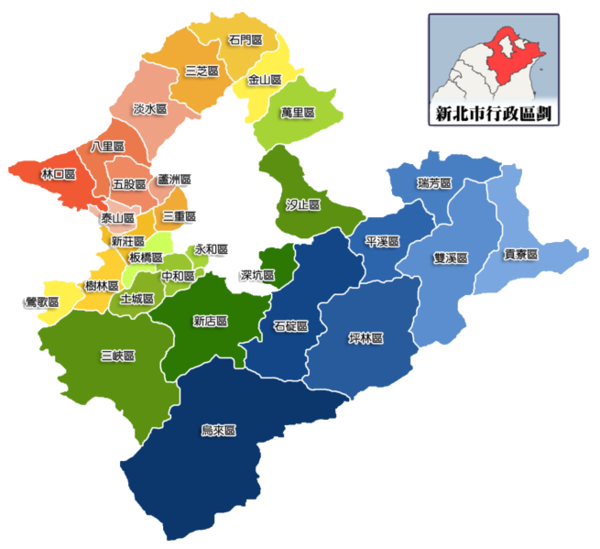
New Taipei City is subdivided into 29 districts, formed by reorganizing the previous administrative units of Taipei County—including cities, towns, and rural townships—upon its elevation to special municipality status in 2010. These districts reflect a mix of urban, suburban, and rural characteristics, with historical urban centers such as Banqiao, Sanchong, Zhonghe, Yonghe, and Xinzhuang serving as densely populated cores adjacent to Taipei City proper. Rural districts like Yingge and Wulai, in contrast, maintain agricultural and indigenous influences with lower development intensity. The 29 districts are:| District | Description |
|---|---|
| Bali District (八里區) | Coastal district with historical ports and tourism focus. |
| Banqiao District (板橋區) | Municipal administrative center and major transport hub. |
| Gongliao District (貢寮區) | Eastern rural area with coastal features and energy facilities. |
| Jinshan District (金山區) | Northern coastal district known for beaches and temples. |
| Linkou District (林口區) | Suburban area with residential and commercial development near Taoyuan Airport. |
| Pingxi District (平溪區) | Mountainous district famous for sky lantern festival and railways. |
| Pinglin District (坪林區) | Tea-producing mountainous area with scenic trails. |
| Ruifang District (瑞芳區) | District with mining history and proximity to tourist sites like Jiufen. |
| Sanchong District (三重區) | Urban district with high population density and manufacturing. |
| Sanxia District (三峽區) | Known for historic old street and educational institutions. |
| Sanzhi District (三芝區) | Coastal agricultural district with wave energy experiments. |
| Shenkeng District (深坑區) | Small district noted for tofu production. |
| Shiding District (石碇區) | Mountainous area with tofu cuisine and waterfalls. |
| Shimen District (石門區) | Northernmost district with caves and aquaculture. |
| Shuangxi District (雙溪區) | Rural eastern district with low density and natural preservation. |
| Shulin District (樹林區) | Suburban residential area with rail connectivity. |
| Tamsui District (淡水區) | Historic port district with riverside tourism and universities. |
| Taishan District (泰山區) | Industrial district supporting aviation logistics. |
| Tucheng District (土城區) | Suburban urban area with growing residential zones. |
| Wanli District (萬里區) | Coastal district with pottery industry and hot springs. |
| Wugu District (五股區) | Logistics and industrial hub near the airport. |
| Wulai District (烏來區) | Indigenous district with hot springs and waterfalls. |
| Xindian District (新店區) | Suburban district with scenic lake and tech parks. |
| Yingge District (鶯歌區) | Famous for ceramics industry and pottery museums. |
| Yonghe District (永和區) | Highly dense urban district with commercial activity. |
| Zhonghe District (中和區) | Residential and commercial district adjacent to Taipei. |
| Xinzhuang District (新莊區) | Historical urban center with sports facilities. |
| Luzhou District (蘆洲區) | Urban district with high density and river views. |
| Fuxing District (復興區) | Rural mountainous district with indigenous communities and reservoirs.[47] |
Governance framework
New Taipei City employs a mayor-council form of government, with the directly elected mayor exercising executive authority over administrative operations and the unicameral city council, comprising 66 members apportioned across 12 electoral districts, handling legislative oversight including budget approval and policy review.[77] The councilors, serving four-year terms, convene in committees focused on areas such as finance, urban development, and public works to scrutinize municipal proposals.[78] The city's fiscal operations are supported by an annual budget exceeding NT$220 billion as of recent years, derived mainly from local revenue sources including property taxes, land value increment taxes, and business taxes, supplemented by central government transfers for infrastructure projects.[79] This funding structure enables allocation across key sectors, with expenditures prioritized for urban renewal, transportation, and environmental management to address the municipality's dense population and expansive territory. Administrative functions are executed through specialized bureaus, including the Department of Urban Development, which oversees land use planning, building permits, and zoning regulations to manage growth in a peri-urban context, and the Environmental Protection Department, responsible for pollution control, waste management, and sustainable development strategies such as green building incentives.[80] [81] Inter-municipal coordination occurs via frameworks in the Greater Taipei metropolitan area, encompassing joint agreements with Taipei City on cross-jurisdictional issues like mass transit expansion and flood mitigation, facilitated by shared regional planning bodies to optimize resource use across boundaries.[82] Efficiency in operations is evidenced by initiatives like the Smart Pavement Management Center, which integrates data analytics for proactive road condition monitoring and repair scheduling, reducing maintenance costs and improving pavement quality metrics through real-time assessments.[83]Politics and Government
Municipal leadership and elections
Hou Yu-ih of the Kuomintang (KMT) has served as mayor since December 25, 2018, following his victory in the 2018 local elections and re-election in 2022.[84] As of October 2025, he continues in office for the 2022–2026 term.[85] Prior to his tenure, Eric Chu (KMT) was the inaugural mayor, elected in 2010 and re-elected in 2014, serving until his resignation on October 20, 2015, to contest the 2016 presidential election.[86] The mayoralty has remained under KMT control since New Taipei City's formation as a special municipality on December 25, 2010, with no successful challenges from the Democratic Progressive Party (DPP). This continuity stems from the KMT's established voter base in the city's suburban and semi-rural districts, where priorities like housing affordability and transport infrastructure align with the party's platform of pragmatic local development over national ideological debates. In the 2018 election, Hou secured the position by emphasizing crime reduction and urban renewal, drawing on his background as a former police chief.[87] The 2022 election saw Hou win a second term with a decisive margin over DPP candidate Lin Chi-hsiao, amid voter concerns over housing costs and economic pressures exacerbated by the COVID-19 pandemic.[88] Turnout approximated 60%, consistent with patterns in special municipality races where local issues drive participation more than partisan loyalty alone. KMT dominance reflects causal factors including the party's effective mobilization of older demographics and its record of advancing infrastructure projects, such as roadway expansions, which address the commuting needs of New Taipei's population reliant on links to Taipei proper. These policies have sustained support by delivering tangible growth amid rapid urbanization.[89]Central government relations
New Taipei City's fiscal operations exhibit a high degree of dependency on central government transfers, which constitute a major portion of its budget and constrain local autonomy in resource allocation. According to analysis by the Taiwan People's Party, central financial transfers accounted for approximately 58.57% of New Taipei's fiscal resources in recent years, underscoring vulnerabilities to national budget priorities and potential cuts that could impact infrastructure and welfare programs.[90] In 2025, for instance, proposed reductions led to the loss of NT$3.04 billion in central funding for key areas like education and emergency services, prompting local officials to decry the move as undermining municipal stability.[91] Major infrastructure projects, such as metro line extensions, further illustrate this reliance, with central approval and funding essential for execution. The Taipei Metro system, serving New Taipei extensively, draws joint financing from the central government, Taipei City, and New Taipei City; recent extensions, including the NT$16.06 billion New Taipei-Taoyuan link approved in August 2025, saw the central government cover NT$9.12 billion, or over half the cost, while local authorities urged faster national approvals to avoid delays in urban connectivity.[92][93] Similarly, land use and urban planning initiatives require oversight and approval from the Ministry of the Interior, as evidenced by New Taipei's regional plan, the first such to be endorsed nationally, which balances development but subjects local zoning to central spatial planning mandates.[94] Resource management tensions highlight instances of central overreach impeding local priorities, particularly in water allocation from nationally controlled reservoirs like Feitsui. As an upstream headwater municipality, New Taipei has experienced territorial conflicts with downstream Taipei over supply distribution, exacerbated by centralized governance that prioritizes metropolitan needs amid droughts, limiting New Taipei's leverage despite its contributions to regional reservoirs.[95] Cooperative elements persist in cross-jurisdictional ventures, such as the Taoyuan Airport MRT, which extends through New Taipei districts and integrates with local networks to enhance northern Taiwan's logistics, though ultimate operational control remains under central aviation authorities.[96] These dynamics reveal a pattern where central fiscal and regulatory dominance can delay autonomous development, fostering calls for greater local fiscal independence to mitigate politicized funding fluctuations.[97]Political controversies and corruption
In New Taipei City, allegations of corruption have frequently centered on urban planning and construction permitting processes, where developers have been accused of exerting undue influence through bribes to secure favorable rezoning and approvals. A notable case emerged in June 2017, when prosecutors raided New Taipei City Hall offices, including the Urban and Rural Development Department, investigating officials for allegedly accepting bribes from developers to issue permits for illegal structures and overlook building code violations.[98] This probe highlighted systemic weaknesses in oversight, as rapid urbanization in the Taipei metropolitan area incentivized shortcuts in enforcement to accommodate developer interests.[99] Further scrutiny arose in 2022 when Farglory Group founder Chao Teng-hsiung was sentenced to 10 years in prison for bribery related to influencing New Taipei City Councilor Chou Sheng-kao, who received a three-year term for accepting illicit payments tied to development projects.[100] The case underscored how large developers could leverage political connections to advance rezoning initiatives, often at the expense of public interest in sustainable planning. In May 2023, Democratic Progressive Party councilors questioned Mayor Hou Yu-yi over purported ties to bribery and bid-rigging scandals in Shihding District, including a NT$1.2 billion procurement irregularity, though Hou denied involvement and no formal charges were filed against him.[101] These incidents reflect broader criticisms of post-democratization policies that prioritized developer-led growth, fostering a housing price surge in New Taipei City—rising 145 percent from 1995 to 2015 to NT$368,000 per ping—and contributing to affordability challenges amid weak regulatory checks.[102] Such favoritism has been linked causally to inflated land values through lax rezoning, exacerbating bubbles in the metropolitan periphery without commensurate infrastructure gains.[103] Prosecutorial efforts have intensified, but persistent developer sway in local governance continues to undermine transparent decision-making.[99]Demographics
Population dynamics and trends
New Taipei City, established on December 25, 2010, from the former Taipei County, began with a population of 4,054,467 residents.[42] This figure reflected decades of suburban expansion as a commuter belt for Taipei, drawing internal migrants from rural Taiwan areas for industrial and service jobs. By 2023, the population had stabilized at approximately 4 million, with estimates projecting modest growth to around 4.05 million by mid-decade amid national demographic pressures.[75] Natural increase remains constrained by Taiwan's persistently low total fertility rate, estimated at 0.87 children per woman in New Taipei City as of 2023, far below the 2.1 replacement level required for population stability without migration.[104] Births have declined sharply, with only limited offsets from in-migration; annual net inflows from other Taiwanese regions, primarily southern provinces, total tens of thousands, supporting slow urban consolidation but insufficient to counter aging and out-migration to Taipei proper. The demographic structure is shifting toward senescence, with roughly 15-18% of residents aged 65 or older by 2023, mirroring Taiwan's national rate of 19.8% and exacerbating pressures on local infrastructure, including elder care facilities and workforce-dependent services.[105] This aging trend, driven by extended life expectancies and sub-replacement fertility, forecasts further dependency ratio increases, potentially reaching super-aged status akin to the national projection of over 20% elderly by late 2025.[106]Ethnic and cultural composition
New Taipei City's ethnic composition is overwhelmingly Han Chinese, accounting for over 95% of the population, mirroring national patterns where Han ancestry dominates due to centuries of migration and assimilation.[107] Within this group, subgroups include Hoklo (descendants of early Fujianese migrants), Hakka (from Guangdong and Fujian origins), and waishengren (post-1949 mainland Chinese arrivals), though precise local breakdowns are not distinctly tabulated beyond national estimates of roughly 70% Hoklo, 15% Hakka, and 10% waishengren overall.[108] Indigenous Austronesian peoples constitute approximately 2%, primarily Atayal in mountainous Wulai District, with their numbers reflecting broader demographic pressures from urbanization and intermarriage rather than isolated preservation.[109] Foreign residents and new immigrants (predominantly from Southeast Asia via marriage migration) represent a small fraction, around 2.6% or over 100,000 individuals as of late 2019, often integrating into Han-dominated communities without forming distinct ethnic enclaves. Cultural expressions show Han assimilation dynamics, with Hakka influences evident in districts like Sanxia through traditions such as the Yimin Festival and indigo dyeing heritage, preserved amid urban expansion.[110] Mandarin serves as the dominant language, used as the primary tongue by over 80% in northern Taiwan including New Taipei, supplanting native dialects like Hoklo or Hakka in daily and official contexts due to post-1945 education policies. Indigenous integration faces challenges, including land tenure disputes in areas like Wulai, where traditional territories overlap with development; some cases have seen partial resolutions via administrative courts in the 2010s, affirming limited indigenous claims against state allocations but often prioritizing broader infrastructure needs.[111] These dynamics underscore a pattern of gradual cultural absorption into Han norms, with empirical data indicating declining native language proficiency among younger indigenous residents.[112] In January 2026, the New Taipei City Council passed the Indigenous Peoples Development Autonomy Ordinance, a local regulation comprising 18 articles aimed at safeguarding indigenous rights. This includes provisions for indigenous language interpretation and mediation committees, cultural and language preservation, educational advancement, social welfare, and housing justice initiatives. Official details are available on the New Taipei City Indigenous Peoples Bureau website.[113]Religious affiliations
Religious affiliations in New Taipei City mirror national Taiwanese trends, characterized by syncretic practices blending Buddhism, Taoism, and Chinese folk religions, which foster social cohesion through shared rituals and community events. Surveys indicate that approximately 66% of the population engages with these traditions, with 19.8% identifying as Buddhist, 18.7% as Taoist, and 27.9% adhering exclusively to folk religions, though overlaps are common as many practitioners incorporate elements from multiple faiths.[114] Christians, including Protestants (around 3.9-5.5%) and Catholics (1.4%), comprise about 6-7% of residents.[115] Roughly 24% report no religious affiliation.[114] Temples maintain high per capita density across Taiwan, estimated at one per square kilometer nationally, with New Taipei hosting numerous sites that function as vital community hubs for worship, dispute resolution, and festivals.[116] Examples include the Zhulinshan Guanyin Temple in Linkou District, a prominent Buddhist site drawing pilgrims for its Guanyin statue and role in local gatherings.[117] Such institutions underscore the embedded role of religion in daily life, supporting social networks amid urbanization. Secularization trends are evident, particularly among youth, with non-religious identification rising due to education, urbanization, and exposure to global influences; national data show a shift away from exclusive Daoist or folk affiliations, contributing to broader disaffiliation rates increasing by several percentage points over recent decades.[118][119] This pattern aligns with East Asian patterns where childhood religious upbringing often gives way to unaffiliated status in adulthood.[120]Economy
Industrial base and growth drivers
New Taipei City's gross domestic product reached approximately NT$2 trillion in 2023, accounting for roughly 10% of Taiwan's national total. This output underscores the city's role as a vital extension of the Taipei metropolitan economy, where geographic adjacency enables seamless supply chain linkages and labor mobility with the capital's high-tech ecosystem, fostering export-oriented production without reliance on heavy state directives.[121] Historically, the region transitioned from an agriculture-dominant base—comprising over 30% of Taiwan's GDP in the early 1950s—to a manufacturing and services-led structure by the post-1980s era, with agricultural output now below 1% of local value added. This shift was propelled by private entrepreneurs responding to global market signals, land reforms that boosted productivity and released rural labor, and incremental infrastructure investments that prioritized trade facilitation over comprehensive industrial policy myths. Empirical evidence from Taiwan's sustained per capita growth, averaging 7-8% annually from 1960-1990, attributes success to decentralized firm-level adaptations and foreign demand rather than top-down intervention.[36] Economic expansion in 2024 approximated 4%, aligning with national figures amid global headwinds, sustained by robust external orders in precision manufacturing despite subdued domestic consumption. This resilience highlights causal drivers like supply chain efficiencies and investor confidence in the region's rule-of-law environment, enabling outperformance relative to more interventionist peers.[122]Manufacturing and high-tech sectors
New Taipei City's high-tech manufacturing is characterized by specialized clusters that leverage geographic proximity and supply chain synergies, exemplifying the efficiencies of private enterprise-driven agglomeration. Xinzhuang District serves as a key hub for electronics production, hosting facilities of firms such as ElectroCraft and Excel Cell Electronic Co., Ltd., which focus on components and assembly for global markets.[123][124] These concentrations facilitate rapid knowledge spillovers and cost reductions through dense networks of suppliers and specialized labor, without reliance on centralized planning. In emerging sectors like biotechnology, New Taipei has pursued consortium-based initiatives to foster innovation, with the city government establishing a dedicated biotech development group in districts including Linkou to integrate startups and research.[125] Linkou's startup infrastructure, such as the Taiwan Startup Terrace hub, supports tech ventures that complement manufacturing by advancing R&D in adjacent high-tech fields.[126] The area also accommodates suppliers to leading semiconductor firms like TSMC, benefiting from Taiwan's overall ecosystem where localized production of materials and equipment has expanded to include advanced nodes.[127] Manufacturing employment underscores the sector's dominance, comprising approximately 36% of total employment as of the latest detailed census data from 2010, reflecting sustained industrial orientation amid Taiwan's shift toward high-value production.[128] Recent transit-oriented development (TOD) projects, including the LG16 metro line agreement signed in 2025, enhance cluster viability by improving access to industrial zones, enabling renewal efforts that link manufacturing sites to urban infrastructure and potentially elevating land values through better connectivity.[129] This private-led clustering has driven output resilience, as evidenced by the persistence of electronics and biotech firms despite global supply disruptions.Logistics and trade hubs
The Port of Taipei, located in Bali District, serves as a primary maritime gateway for New Taipei City, facilitating substantial cargo throughput integral to regional trade. With an annual capacity of approximately 27.9 million tons of cargo, including containers, bulk goods, and general freight, the port supports diverse logistics operations such as automotive distribution and international transshipment.[130][131] This infrastructure, encompassing multiple terminals, enables handling of vessels up to 80,000 tons and over 2 million TEUs annually, positioning it as a key node in Taiwan's northern logistics network.[131] Adjacent to the Port of Taipei, the Port of Taipei Free Trade Zone spans 269.9 hectares across east, south, and north terminal areas, optimizing sea-air intermodal transport and value-added services like warehousing and assembly.[132] This zone, integrated with nearby Wugu District's industrial parks, streamlines customs procedures with zero-duty transactions for approved activities, enhancing efficiency for exporters and importers.[132] The proximity to Taoyuan International Airport, approximately 20-30 kilometers away, fosters seamless multimodal logistics, where sea cargo can transfer to air freight for time-sensitive shipments, bolstering New Taipei's role in global supply chains.[132][133] National Highway 1 (NH1), traversing New Taipei City, interconnects the port facilities with inland industrial zones and Taoyuan Airport, enabling rapid just-in-time delivery critical for high-tech and manufacturing logistics.[134] This highway infrastructure reduces transit times, supporting efficient inventory management and minimizing delays in regional trade flows.[134] While Taiwan's ports remain under public management via the Taiwan International Ports Corporation, operational enhancements have improved throughput, though full privatization impacts on efficiency remain limited in this state-dominated sector.[135]Economic challenges and inequalities
New Taipei City grapples with pronounced economic inequalities, mirroring Taiwan's national household Gini coefficient of 0.339 in 2023, which indicates moderate but persistent income disparities driven by concentrated wealth in urban real estate and high-tech sectors.[136] These gaps are amplified within the city by contrasts between densely industrialized core districts like Banqiao and peripheral rural areas such as Pinglin, where limited access to advanced manufacturing and logistics hubs results in lower wage growth and higher vulnerability to economic shocks.[137] Policy constraints, including rigid zoning laws that preserve agricultural land and restrict urban expansion, have hindered equitable development by favoring established property interests over broad supply increases, thereby entrenching wealth divides.[138] A central challenge is the housing affordability crisis, where median home prices in New Taipei reached ratios of approximately 15 to 20 times annual household income by 2023, far exceeding global benchmarks and pricing out younger workers and lower-income families.[139] [140] This stems from over-regulation in land conversion and building approvals, which, despite intentions to protect farmland, have suppressed new construction amid population pressures from the city's role as Taipei's commuter belt, leading to rental burdens exceeding 30% of income for many households.[141] Consequently, homeownership rates among those under 40 have stagnated, exacerbating intergenerational inequality as asset appreciation accrues disproportionately to existing owners.[142] Post-COVID recovery has unevenly affected small and medium-sized enterprises (SMEs), which dominate New Taipei's economy outside high-tech enclaves, with traditional manufacturing firms facing heightened closure risks due to supply chain disruptions and subdued domestic demand in 2023.[143] While overall unemployment remained low at around 3.9% historically in the city, youth joblessness peaked at over 12% nationally in 2025, reflecting skill mismatches and slower reabsorption of labor in peripheral districts reliant on labor-intensive industries.[144] [145] These dynamics underscore policy shortcomings in fostering SME resilience through deregulation and targeted retraining, rather than relying on broad subsidies that fail to address structural rigidities.[146]Infrastructure and Transportation
Rail and mass transit systems
New Taipei City's rail and mass transit infrastructure integrates extensions of the Taipei Metro with dedicated New Taipei Metro lines, facilitating high-volume commuter flows across its urban and suburban districts. Key components include Taiwan Railways Administration (TRA) lines such as the Yilan and Pingxi branches serving eastern areas like Ruifang and Shifen, alongside urban rapid transit focused on western population centers. The Taiwan High Speed Rail (THSR) connects via Banqiao Station, a multimodal hub linking THSR, TRA, Taipei Metro's Bannan (Blue) and Xiaonanmen (Green) lines, and New Taipei Metro services, enabling seamless transfers for intercity and local travel.[147][148] The New Taipei Metro operates the Danhai Light Rail, a 14.2 km automated line from Tamsui to New Taipei Industrial Park opened in January 2020, alongside the 7.7 km Ankeng Light Rail serving southern districts since December 2023. These light rail systems prioritize accessibility in lower-density zones, with recent upgrades increasing Danhai's operational speeds from 10 km/h to 60 km/h at manual switches to boost efficiency. The Circular Line's Phase 1, a 15.4 km elevated and automated segment with 14 stations from Dapinglin to New Taipei Industrial Park, commenced operations on January 31, 2020, encircling core industrial and residential nodes to alleviate radial congestion on legacy MRT lines.[97][149][150] Collectively, these systems handle approximately 100,000 daily passengers across Danhai, Ankeng, and Circular Line operations as of mid-2025, reflecting robust uptake driven by fare policies kept low to encourage ridership in expanding suburbs. Since Phase 1 launches in late 2018, overall New Taipei Metro passenger volumes have surged 830%, underscoring the causal efficacy of targeted extensions in high-commute corridors like Banqiao, where per capita density exceeds 20,000 residents per square kilometer, justifying infrastructure costs through reduced private vehicle dependency and modal shifts evidenced by system-wide growth.[151][97] Ongoing expansions, including the Sanying Line under construction and the Wanda-Zhonghe Line projected for 2027 completion at 81.7% progress, emphasize integration with existing networks to scale capacity amid population pressures, with ridership metrics indicating positive returns on investment via sustained volume increases rather than isolated cost metrics.[152][97]Road networks and traffic management
New Taipei City's road network features key segments of National Freeway 1, known as the Sun Yat-sen Freeway, and National Freeway 3, which traverse the municipality and connect it to Taipei City and other regions, supporting high-volume interurban travel.[153] These highways incorporate electronic toll collection (ETC) systems with multi-lane free-flow gantries and distance-based pricing, implemented nationwide since 2013 to streamline payments, reduce queuing delays, and promote usage-based charges over flat fees or subsidies.[154] ETC adoption, facilitated by eTags offering a 10% discount for participants, has enhanced throughput on these corridors by minimizing stops and enabling dynamic traffic flow management.[155] The city registers over 3 million motor vehicles, contributing to dense traffic loads exacerbated by urban sprawl and mixed vehicle types, including scooters and larger automobiles designed for right-hand drive systems that hinder efficient merging.[156] [157] Intelligent transportation initiatives, such as AI-assisted signal controls and real-time violation detection, aim to mitigate peaks; similar systems in adjacent areas have cut average delays by up to 14.5% through adaptive timing.[158] [159] Despite investments, congestion persists due to high population density and inadequate segregation of pedestrians, vehicles, and parking, with sprawl amplifying bottlenecks on peripheral routes.[160] Market-oriented tolling via ETC demonstrates superior causal efficacy in curbing overuse compared to expanded subsidies for road building, as distance charges internalize congestion costs without distorting incentives through non-price rationing.[154] Critics note that without broader application of variable pricing, infrastructure expansions alone fail to address induced demand from low marginal costs.[161]Air and port connectivity
New Taipei City maintains strong air connectivity through its proximity to Taiwan Taoyuan International Airport (TPE) in adjacent Taoyuan City, the principal international hub for northern Taiwan and a key driver of regional economic activity. In 2024, TPE processed approximately 44 million passengers, nearing pre-pandemic levels and generating spillovers in logistics, tourism, and trade that bolster New Taipei's industrial and service sectors, including employment in cargo handling and ancillary services.[162] The airport's cargo throughput, exceeding 1.1 million metric tons in the first half of 2024 alone, supports New Taipei's export-oriented manufacturing via integrated logistics networks and dedicated terminals accessible from the city.[163] Access to TPE is facilitated by Freeway No. 1 and the Taoyuan Airport MRT system, which links the airport to Taipei Main Station in about 35 minutes, enabling efficient commuter and freight movement into New Taipei districts like Linkou and Taishan; however, expressway congestion during peak hours creates bottlenecks, exacerbating delays for airport-bound traffic from the densely populated areas.[96] The Port of Taipei in Bali District provides essential maritime connectivity, handling containers and bulk cargo as part of Taiwan International Ports Corporation's (TIPC) network, which achieved 13.93 million TEU in total throughput for 2024 amid ongoing capacity enhancements.[164] Recent upgrades, including land reclamation in the logistics zone, have improved berthing and handling efficiency, contributing to national port revenue highs of NT$22.8 billion despite modest localized growth rates.[165] These developments sustain New Taipei's role in regional trade, particularly for northern industrial exports, though the port's scale remains secondary to southern facilities like Kaohsiung.[166] Expressway linkages, such as Provincial Highway No. 61, connect the port to inland hubs, but similar peak-period traffic constraints apply.Urban development projects
New Taipei City has advanced urban renewal through projects emphasizing mixed-use development and infrastructure upgrades to support its population exceeding 4 million. The Xinban Special District in Banqiao District exemplifies this approach, covering 54 hectares as a central hub for administration, commerce, and transit since its conceptualization in the 1990s and phased construction from the 2000s. This initiative integrates high-density residential towers, retail spaces, and connectivity via New Banqiao Station, fostering economic activity while aiming to alleviate congestion in adjacent Taipei.[167][168] Transit-oriented development (TOD) strategies have targeted areas near mass rapid transit stations to densify land use and boost property values. In Sanchong District, 2020s rezoning and projects like "Wandering with Wind" have expanded green plazas, widened sidewalks, and removed barriers to enhance urban livability, aligning with broader regional plans dividing the city into multi-core growth zones. These efforts promote compact expansion, with studies on high-density metropolises indicating potential for 20-30% value uplifts in station-proximate zones through improved accessibility, though specific New Taipei metrics remain context-dependent.[169][94][170] Urban renewal has yielded over 100,000 new housing units since 2010, including social housing to address affordability, amid national additions of 200,000 units by 2024. Projects like transfer of development rights in historic areas seek to balance preservation with modernization, mitigating displacement by allowing coexistence of traditional industries and new builds. However, growth benefits are tempered by risks of resident displacement in renewal zones and inadequate coordination, as evidenced by 2024 analyses critiquing developer-driven sprawl and persistent policy gaps.[139][171][172] Flood vulnerabilities persist in low-lying developed areas, where rapid urbanization has intensified exposure despite resiliency measures, with simulations showing substantial risk under extreme events. Critics highlight unsustainable expansion exacerbating these hazards, underscoring needs for better integrated planning to avoid crisis-reactive approaches.[173][174][175]Education and Research
Higher education institutions
New Taipei City hosts several prominent higher education institutions, with major universities collectively enrolling over 50,000 students as of recent data. Key establishments include National Taipei University (NTPU) in Sanxia District, with approximately 7,667 students focused on business administration, law, and social sciences alongside engineering disciplines; Fu Jen Catholic University (FJU) in Xinzhuang District, enrolling about 20,339 students across comprehensive programs including engineering and management; Tamkang University (TKU) in Tamsui District, with 21,656 students emphasizing engineering, business, and technology fields; and Ming Chi University of Technology (MCUT) in Taishan District, serving 4,124 students primarily in applied engineering and technical programs.[176][177][178][179] These institutions align their curricula with New Taipei's technology-driven economy, prioritizing engineering and business education to foster industrial innovation; for instance, TKU and MCUT maintain strong emphases on mechanical, electrical, and materials engineering, while NTPU integrates e-business research with industrial economics.[180][181] Research outputs are empirically mid-tier nationally, with NTPU ranking 26th in Taiwan across 97 evaluated topics, achieving top-50% performance in areas like engineering and business management, though patent filings per capita lag behind elite institutions like National Taiwan University.[182] FJU and TKU similarly contribute to regional outputs in applied sciences, but overall institutional innovation metrics, including citations from patents, place them below top national performers per SCImago assessments.[183] Smaller institutions like Aletheia University in Tamsui, with 4,299 students, offer liberal arts and social sciences but face enrollment challenges, registering below 60% capacity in recent admissions cycles.[184][185] Empirical evaluations highlight these universities' roles in supporting local high-tech sectors through targeted programs, though research impact remains constrained by funding and scale compared to Taipei-based peers.[186]Public education system
New Taipei City's public K-12 education system operates under Taiwan's national framework of 12-year compulsory basic education, encompassing kindergartens, elementary schools (grades 1-6), junior high schools (grades 7-9), and senior high schools or vocational schools (grades 10-12). The system includes over 400 public institutions serving approximately 300,000 students, reflecting the city's large youth population amid Taiwan's overall enrollment of about 2.5 million in primary and secondary levels.[187][188] Performance metrics highlight strengths in quantitative subjects, with Taiwan's 15-year-olds, including those from New Taipei, scoring 547 in mathematics on the 2022 PISA assessment—well above the OECD average of 472—alongside 537 in science and 515 in reading compared to OECD baselines of 485 and 476, respectively. These outcomes stem from a curriculum emphasizing rigorous drill in foundational skills, though critics argue this approach fosters rote memorization at the expense of creativity and problem-solving, as evidenced by persistent domestic dissatisfaction despite international rankings.[189][190][191][192] Challenges include teacher shortages, particularly in rural and remote districts like Pingxi and Shiding, where over 2,600 national vacancies were reported at the start of the 2025 academic year, exacerbating staffing issues in less urbanized areas due to lower incentives for relocation. Dropout rates in compulsory education remain low, with junior high enrollment exceeding 99.9%, though indirect metrics such as rising student stress—reported by 75.9% in a 2024 survey—and alternative education pathways suggest underlying disengagement from the rigid central guidelines.[193][194] To enhance competitiveness, New Taipei launched bilingual education initiatives in the late 2010s, expanding through the Bilingual School Program to integrate English immersion in select elementary and secondary schools by the 2020s, aiming to cultivate global proficiency amid criticisms of uneven implementation and teacher qualifications.[195][196]Libraries and research centers
New Taipei City maintains the largest public library system in Taiwan, consisting of 107 branches distributed across its 29 administrative districts, ensuring broad accessibility for residents.[197] The flagship New Taipei City Main Library, operational since 2015, incorporates advanced features such as 24-hour self-service checkout stations powered by UHF RFID technology, marking it as a pioneer in automated library operations.[198] Digital transformations have enhanced service efficiency, including IoT-enabled inventory management, online seat reservations, and a mobile app for borrowing and returns, which streamline user interactions and reduce physical bottlenecks.[199] These innovations correlate with observed upticks in engagement, such as a 50% rise in visitors at upgraded branches like Taishan compared to prior periods.[200] Public funding supports ongoing enhancements, with the city allocating NT$5.3 billion in 2025 for library upgrades and a second main library to sustain growth amid rising demand.[201] Key research facilities include the National Taiwan Library in Zhonghe District, which houses specialized collections for Taiwan studies, reference services, and multimedia resources dedicated to scholarly inquiry.[202] While prominent industrial research entities like the Industrial Technology Research Institute maintain primary operations outside the city, local satellites and affiliated programs contribute to applied technology development in sectors such as materials and electronics, though detailed branch impacts remain limited in public records.[203] These centers emphasize empirical data access, supporting regional innovation without overlapping higher education mandates.Culture and Society
Religious sites and practices
New Taipei City features numerous temples that embody the syncretic fusion of Taoism, Buddhism, and Chinese folk religion prevalent in Taiwan, where deities from multiple traditions coexist in shared worship spaces. Prominent sites include the Sansia Zushi Temple, renowned for its intricate wood carvings and dedication to the Zushi deities, and the Wuji Tianyuan Temple, noted for its elaborate architecture and Taoist practices. Other key locations encompass the Tian Yuen Temple and Banqiao Cihui Temple, which attract devotees for rituals involving incense offerings, joss paper burning, and divination methods such as kau-chim bamboo cups.[204][205][206] These temples serve vital community functions beyond worship, functioning as hubs for social support networks, particularly in disaster response. During typhoons, such as recent events in 2025, temples have been repurposed as coordination centers for relief distribution, shelter, and aid mobilization, leveraging their established local ties to facilitate rapid assistance. Buddhist organizations like Tzu Chi, with roots in temple-based philanthropy, have exemplified this role since establishing standardized relief models after Typhoon Nora in 1973, extending operations across regions including New Taipei.[207][208] Attendance at these sites remains high among older demographics for routine rituals, yet surveys reveal a marked decline in youth participation, with half of East Asian adults, including Taiwanese, disaffiliating from childhood religions by adulthood. This trend aligns with broader patterns of reduced public ritual engagement in secularizing societies, though temples continue drawing crowds for specific practices amid Taiwan's overall religious landscape of over 12,000 temples nationwide.[120][209][210]Sports and recreational facilities
New Taipei City features several prominent sports venues that support professional and amateur competitions. The Banqiao Stadium, a multi-purpose facility in Banqiao District opened in 1987, has a seating capacity of 30,000 and primarily hosts football matches along with track and field events.[211] The Xinzhuang Baseball Stadium in Xinzhuang District, established in 1997, accommodates 12,500 spectators and serves as the home ground for the Fubon Guardians, a team in Taiwan's Chinese Professional Baseball League (CPBL), which draws significant local attendance for regular season games and playoffs.[212][213] These stadiums facilitate community engagement in team sports, contributing to Taiwan's national baseball prominence, where CPBL participation has sustained high viewership despite post-pandemic adjustments.[213] Recreational infrastructure includes extensive trail networks and urban parks designed for public health and outdoor activities. The Smile Trails system comprises 108 kilometers of accessible mountain paths connecting urban areas to nearby hills, promoting hiking and light exercise for residents.[214] The New Taipei Metropolitan Park offers nearly 10 kilometers of riverside paths integrated with green spaces, supporting cycling, jogging, and family outings.[215] These facilities have bolstered physical activity levels, aligning with Taiwan-wide trends where regular sports participation reached 82.6% of the population in 2023, reflecting a modest rebound from COVID-19 disruptions through increased outdoor usage.[216] Local training programs at these venues have supported athletic development, with facilities like Xinzhuang contributing to the pipeline for national competitors in baseball and other disciplines, though specific Olympic qualifiers from New Taipei remain integrated into broader Taiwanese representation rather than city-attributed achievements.[217] Overall, such infrastructure correlates with improved community health metrics, as evidenced by sustained engagement in organized sports and recreation amid rising national exercise rates post-2020.[216]Festivals and night markets
Night markets in New Taipei City, such as Banqiao and Nanya, function as essential economic and cultural venues, providing informal employment opportunities and distributing agricultural products to urban consumers. These markets support local vendors by offering a low-barrier entry for small-scale entrepreneurs, contributing to Taiwan's broader night market economy, which generated NT$508.1 billion in revenue in 2008 alone.[218][219] The Pingxi Sky Lantern Festival, aligned with the annual Lantern Festival, draws over 100,000 visitors to the district, where participants release illuminated sky lanterns, stimulating short-term economic activity through related tourism and vendor sales.[220] In 2025, thousands gathered in Pingxi for the event, underscoring its role in preserving local traditions while boosting nearby commerce.[221] Despite their vibrancy, night markets encounter hygiene and safety challenges stemming from high vendor density and inconsistent practices, including limited food safety knowledge among operators. Research highlights poor hygiene adherence, such as inadequate handwashing and food handling, elevating risks of contamination in humid conditions.[222] Local authorities have responded with certifications like Taipei's Food Safety Smile program to monitor standards, though enforcement varies.[223]Environment and Sustainability
Energy production and consumption
New Taipei City's electricity supply is integrated into Taiwan's national grid operated by Taiwan Power Company (Taipower), with consumption driven primarily by dense industrial activity in districts such as Xinzhuang and Sanchong. In 2017, the city's total electricity consumption reached approximately 21 million thousand kWh, reflecting its role as a manufacturing hub for electronics and petrochemicals.[224] Per capita electricity use aligns closely with Taiwan's national average of about 12.1 MWh annually as of 2024, though industrial sectors elevate demand beyond residential levels, contributing to higher overall intensity compared to less urbanized regions.[225] Local energy production is limited and heavily dependent on imported fuels, exemplified by the Linkou Thermal Power Plant in Linkou District, which has an installed capacity of 2,400 MW from supercritical coal-fired units commissioned in the 2010s.[226] Taiwan imports over 97% of its total energy requirements, with fossil fuels—primarily coal, oil, and natural gas—dominating the mix and comprising roughly 80% of Taipower's generation in recent years.[227][228] This import reliance exposes New Taipei's energy security to geopolitical risks, supply disruptions, and fluctuating global prices, as domestic resources are negligible and coal for facilities like Linkou must be sourced abroad. National policies aim to reduce coal's share in electricity generation, though Linkou units continue operating amid delays in broader phase-out timelines originally targeted for 2025.[229] Taipower's grid delivers reliable service to New Taipei, with infrequent major blackouts—only three island-wide incidents recorded in the past seven years as of 2024—despite occasional localized outages from equipment failures or maintenance.[230] Such stability supports the city's economic output but underscores the fragility of fossil fuel-dependent systems, where external shocks could amplify vulnerabilities given the absence of significant local alternatives.[231]Green initiatives and policies
New Taipei City became the first locality in Taiwan to publish a Voluntary Local Review (VLR) on the United Nations Sustainable Development Goals in October 2019, marking it as the tenth city globally to do so; the report outlined localized progress and commitments across environmental indicators, including energy efficiency and emissions reduction.[232] In November 2020, the city issued Taiwan's inaugural Climate Emergency Declaration, accompanied by a "5 + 5" strategy framework targeting key 2030 climate objectives such as emissions cuts and resilience building.[233] The city's Climate Action Plan emphasizes measurable interventions, including the replacement of over 110,000 traditional streetlights with LED fixtures by 2020, which has yielded annual electricity savings estimated at NT$150 million for municipal operations.[234] These retrofits, utilizing recyclable materials in over 90% of components, are projected to avert approximately 90,000 tons of CO2 emissions over their lifespan, based on reduced energy consumption relative to prior sodium-vapor systems, though net environmental gains hinge on grid decarbonization rates.[235] Progress under the plan is monitored through periodic reviews of carbon reduction metrics, with the 2022 achievement of coal-free industrial status—eliminating coal dependency in local manufacturing ahead of timeline—serving as a concrete milestone in fossil fuel phase-out.[236][237] In 2022, New Taipei advanced its long-term framework with the release of a 2050 Net-Zero Roadmap and Climate Action White Paper, shifting from incremental low-carbon measures to comprehensive zero-emission pathways, including incentives for clean energy adoption in businesses and public-private partnerships for efficiency upgrades.[238] These policies promote solar and renewable integration alongside afforestation to bolster carbon sinks, though verifiable city-level renewable penetration remains tied to national grid dynamics, with Taiwan's overall solar capacity reaching about 12.5 GW by late 2024 against a 20 GW target.[239][81][240]Environmental criticisms and risks
New Taipei City faces persistent air quality challenges, particularly from fine particulate matter (PM2.5), with annual averages in the region around 16-20 µg/m³, exceeding the World Health Organization's guideline of 5 µg/m³ by a factor of 3-4 times.[241][242] Winter conditions exacerbate this, as stagnant weather patterns combined with industrial emissions and traffic can drive PM2.5 concentrations to peaks of 56 µg/m³ or higher, surpassing WHO 24-hour interim targets of 15 µg/m³ and contributing to health risks like respiratory issues.[243] These levels stem partly from nearby manufacturing zones in districts like Linkou and industrial activities along the Danshui River, where emissions monitoring data indicate ongoing contributions from secondary aerosols and volatile organics.[241] Urbanization has intensified flood risks through the expansion of impervious surfaces, which reduce natural infiltration and amplify runoff during heavy rains—a phenomenon documented in vulnerability assessments showing heightened exposure in low-lying areas like Tamsui and Xinzhuang.[244] Studies from 2021 onward highlight evolving flood patterns, with urban sprawl replacing permeable land and increasing peak discharge rates, as evidenced by post-typhoon events where drainage overloads led to widespread inundation despite infrastructure upgrades.[174] This built-environment shift, accelerated since the city's 2010 formation, has outpaced adaptive measures in some districts, resulting in recurrent flash flooding that endangers over 4 million residents.[245] Critics of urban renewal initiatives argue they often prioritize density over ecology, leading to net losses in usable greenspace and fragmented habitats amid high-rise developments in areas like Banqiao and Sanchong.[246] Evaluations indicate unequal greenspace access affects nearly 64% of planning zones, with renewal projects sometimes converting informal or peripheral green areas into concrete, diminishing biodiversity buffers against heat and pollution.[247] Coordination shortcomings between municipal agencies and central authorities further impede holistic adaptation, as siloed planning in coastal zones like Tamsui fails to integrate sea-level rise projections with land-use decisions, leaving vulnerabilities unaddressed despite available modeling tools.[248][174]Tourism and Attractions
Historical and cultural landmarks
Fort San Domingo, located in Tamsui District, stands as one of New Taipei City's premier historical landmarks, originally constructed as a wooden fort by Spanish colonists in 1628 to assert control over local populations and facilitate trade.[249] The structure changed hands multiple times, passing to Dutch forces in 1641, Qing Dynasty control in 1683, and later serving British consular purposes until 1874 before Japanese occupation and post-war Taiwanese administration.[250] Designated a class 1 historical monument by Taiwan's Ministry of the Interior on May 26, 1983, it exemplifies colonial-era fortifications and draws visitors interested in maritime history.[251] The Lin Family Mansion and Garden in Banqiao District represents Taiwan's most intact example of traditional Chinese garden architecture, built starting in 1847 by the affluent Lin Ben Yuan family, merchants who amassed wealth through salt and shipping trades.[252] Preservation efforts have focused on restoring structures to their original Qing-era configurations, minimizing modern alterations to maintain historical fidelity, with some family descendants still residing in portions of the complex.[253] As a designated national historical monument, it highlights 19th-century elite residential design, including pavilions, ponds, and rockeries, contributing to cultural tourism without specified restoration cost disclosures in public records. In Ruifang District, the Gold Museum, established in 2004 by New Taipei City government, preserves the legacy of Taiwan's early 20th-century gold mining boom under Japanese colonial rule, utilizing former mining facilities and ecology park grounds for exhibits on extraction techniques and economic impacts.[254] The site attracted approximately 1 million visitors in 2024, underscoring its role in educational tourism and local revenue generation from entry fees and related activities.[255] Jiufen's old streets in Ruifang District form a cultural landmark tied to the same mining heritage, with narrow lanes lined by teahouses and shops evoking early 20th-century mining town aesthetics, drawing over 3.2 million tourists in 2024.[255] However, rapid commercialization has sparked concerns over authenticity erosion, as souvenir vendors and mass tourism dilute original residential and industrial character, prompting calls for sustainable management to balance economic benefits against cultural preservation.[256][257]Natural and recreational sites
Shifen Waterfall, located in Pingxi District, stands as one of New Taipei City's premier natural attractions, measuring 20 meters in height and 40 meters in width as a curtain-style cascade on the upper Keelung River.[258] Its horseshoe shape and frequent rainbows in the mist have earned it the nickname "Taiwan's Little Niagara," drawing visitors via the nearby Pingxi Railway Line for short hikes to viewing platforms.[259] The site's accessibility supports recreational activities like photography and light trekking, though seasonal water flow varies significantly.[260] Yehliu Geopark in Wanli District exemplifies coastal geological features formed by wave erosion on a 1.7-kilometer cape, featuring hoodoo rocks and the prominent Queen's Head, a mushroom-shaped formation resembling a profile that developed over approximately 4,000 years through differential erosion of softer sandstone layers.[261] Other notable structures include the Fairy's Shoe and Candle Rock, illustrating processes like sea erosion and wind abrasion that continue to alter the landscape, with conservation measures in place to mitigate damage from high visitor traffic exceeding millions annually.[262] The geopark serves as an educational recreational site, with boardwalks guiding tourists through mushroom rocks and fossil-embedded strata, emphasizing the area's tectonic history tied to the Datun Volcano Group.[263] Bitan Scenic Area in Xindian District provides riverine recreation along the Xindian River gorge, where visitors engage in boating, paddleboarding, and pedestrian walks across the 150-meter Bitan Suspension Bridge, offering panoramic views of cliffs and water features.[264] The zone includes trails like the Hermeishan Hiking Trail for moderate exertion amid subtropical vegetation, supporting activities such as fishing and picnicking on terraced banks.[265] Public infrastructure, including illuminated night paths, enhances year-round usability, though water levels influence boating availability.[266] New Taipei Metropolitan Park in Wugu District integrates 68 hectares of wetlands, ponds, and trails for urban recreation and biodiversity observation, featuring boardwalks over marshes that host bird species and aquatic plants as part of flood mitigation design.[267] These sites collectively preserve pockets of Taiwan's coastal and riverine ecosystems, with geoparks and waterfalls contributing to local endemism in flora and fauna, though urban encroachment poses ongoing habitat pressures.[268]Theme parks and entertainment
Yehliu Ocean World in Wanli District operates as Taiwan's inaugural oceanarium, showcasing marine species through exhibits and live performances including dolphin shows and diving demonstrations.[269] The facility draws families seeking interactive aquatic entertainment, with ticketed access emphasizing educational elements alongside spectacle.[270] New Taipei Metropolitan Park in Sanchong District incorporates extensive amusement features, notably Taiwan's largest array of 31 public slides varying in size and thrill level, complemented by over 100 recreational installations suitable for all ages.[271] These free facilities, accessible via direct MRT integration including a prominent slide from the station exit, promote inclusive play without entry fees, fostering high local utilization as a low-barrier family destination.[272] Zepp New Taipei, situated in Xinzhuang District and inaugurated in 2020, functions as a premier concert hall accommodating up to 2,245 standing patrons or 1,025 seated.[273] The venue hosts diverse programming from domestic indie acts to global tours, capitalizing on New Taipei's urban density for scalable attendance. Such performance spaces generate revenue through ticketing and concessions, though specific annual figures remain undisclosed; broader Taiwanese cultural subsidies for music production have faced scrutiny for favoring insiders over market-driven outcomes, potentially distorting efficient resource allocation.[274] These entertainment options sustain modest draws relative to Taiwan's major theme parks elsewhere, with operational reliance on proximity to Taipei's visitor base rather than standalone subsidies, which appear absent or minimal for these sites based on available public records. Post-2010 infrastructure enhancements across regional parks have prioritized safety through standardized equipment and maintenance protocols, yielding fewer reported incidents compared to earlier decades.[275] Overall economic contributions align with New Taipei's tourism role, channeling expenditures into adjacent commerce without dominating regional GDP metrics.[276]References
- https://en.wikivoyage.org/wiki/New_Taipei