Hubbry Logo
WroxeterWroxeterMain
Open search
Wroxeter
Community hub
Wroxeter
logo
8 pages, 0 posts
0 subscribers
Be the first to start a discussion here.
Contribute something
Wroxeter
Wroxeter
from Wikipedia

Wroxeter (/ˈrɒksɪtər/ ROK-sit-ər) is a village and former civil parish, now in the parish of Wroxeter and Uppington, in the Shropshire district, in the ceremonial county of Shropshire, England. It is beside the River Severn, 5 miles (8.0 km) east-south-east of Shrewsbury. In 1961 the parish had a population of 657.[1]

Key Information

Viroconium Cornoviorum, the fourth largest city in Roman Britain, was sited here, and is gradually being excavated. In 2024, archaeologists uncovered a 2,000-year-old mosaic depicting dolphins and fish.[2]

The village contains one of Shropshire's commercial vineyards.

History

[edit]

Roman Wroxeter, near the end of the Watling Street Roman road that ran across Romanised Celtic Britain from Dubris (Dover), was a key frontier position lying on the bank of the River Severn whose valley penetrated deep into what later became known as Wales, and also on a route south leading to the Wye valley.

Archaeology has shown that the site of the later city first was established about AD 55 as a frontier post for a Thracian legionary cohort located at a fort near the Severn river crossing.[3] A few years later a legionary fortress (castrum) was built within the site of the later city for the Legio XIV Gemina during their invasion of Wales.

The local British tribe of the Cornovii had their original capital (also thought to have been named *Uiroconion) at the hillfort on the Wrekin. When the Cornovii were eventually subdued their capital was moved to Wroxeter and given its Roman name.

This legion XIV Gemina was later replaced by the Legio XX Valeria Victrix which in turn relocated to Chester around AD 88. As the military abandoned the fortress the site was taken over by the Cornovians' civilian settlement.

The name of the settlement, meaning "Viroconium of the Cornovians", preserves a native Brittonic name that has been reconstructed as *Uiroconion ("[the city] of *Uirokū"), where *Uiro-ku (lit. "man"-"wolf") is believed to have been a masculine given name meaning "werewolf".[4][5]

The ruins of Viroconium's public baths at Wroxeter

Viroconium prospered over the next century, with the construction of many public buildings, including thermae and a colonnaded forum. At its peak, it is thought to have been the 4th-largest settlement in Roman Britain, with a population of more than 15,000.[6]

The Roman city is first documented in Ptolemy's 2nd century Geography as one of the cities of the Cornovii tribe, along with Chester (Deva Victrix).

Following the Roman withdrawal from Britain around AD 410, the Cornovians seem to have divided into Pengwern and Powys, although the territorial name may have continued into this period.[7] The minor Magonsæte sub-kingdom also emerged in the area in the interlude between Powysian and Mercian rule. Viroconium may have served as the early post-Roman capital of Powys prior to its removal to Mathrafal sometime before 717, following famine and plague in the area. The city has been variously identified with the Cair Urnarc[8] and Cair Guricon[9] which appeared in the 9th-century History of the Britons's list of the 28 cities of Britain.[10]

A lidar view of Wroxeter and part of the old Roman city wall

N. J. Higham proposes that Wroxeter became the eponymous capital of an early sub-Roman kingdom known as the Wrocensaete, which he asserts was the successor territorial unit to Cornovia. The literal meaning of Wrocensaete is 'those dwelling at Wrocen', which Higham interprets as Wroxeter. It may refer quite specifically to the royal court itself, in the first instance, and only by extension to the territory administered from the court.[11] The Roman city was rediscovered in 1859 when workmen began excavating the baths complex.[12][16] A replica Roman villa was constructed in 2010 for a Channel 4 television programme called Rome Wasn't Built in a Day and was opened to the public on 19 February 2011.[17]

On 1 April 1986 the parish was abolished and merged with Uppington to form "Uppington & Wroxeter".[18]
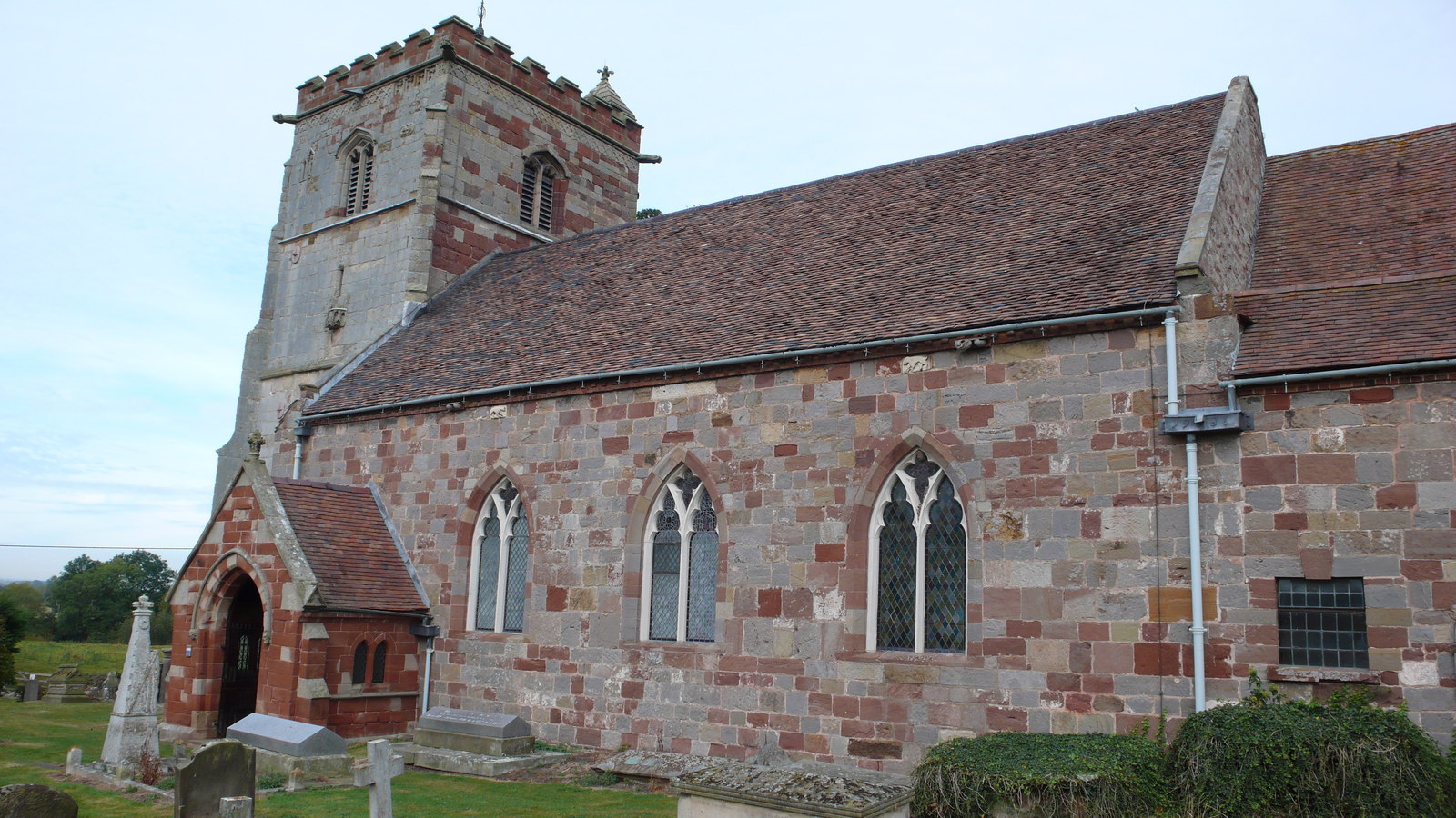
St Andrew's

[edit]

At the centre of Wroxeter village is Saint Andrew's parish church, some of which is built from re-used Roman masonry. The oldest visible section of the church is the Anglo-Saxon part of the north wall which is built of Roman monumental stone blocks. The chancel and the lower part of the tower are Norman.[19] The gatepiers to the churchyard are a pair of Roman columns and the font in the church was made by hollowing out the capital of a Roman column.[20] Later additions to the church incorporate remains of an Anglo-Saxon preaching cross and carvings salvaged from nearby Haughmond Abbey following the Dissolution of the Monasteries.

St. Andrew's was declared redundant in 1980 and is now managed by The Churches Conservation Trust. St. Andrew's parish is now united with that of St. Mary, Eaton Constantine.[21]

Literary reference

[edit]

A. E. Housman visited the site and was impressed enough to write of "when Uricon the city stood", the poem ending "Today the Roman and his trouble Are ashes under Uricon."[22]

Bernard Cornwell has the main character of The Saxon Stories visit Wroxeter in Death of Kings, referring to it as an ancient Roman city that was "as big as London" and using it as an illustration of his pagan beliefs that the World will end in chaos.[23]

Sport

[edit]

The village previously had a football team named Wroxeter Rovers. In 2017, the club relocated to nearby Shrewsbury and was renamed to Shrewsbury Juniors, in order to provide a senior football team for children progressing through the club's junior football system to take part in after the age of 16–17.[citation needed] The club were champions of the Shropshire County League Premier Division in 2020-21.

See also

[edit]

References

[edit]

Further reading

[edit]
[edit]
Revisions and contributorsEdit on WikipediaRead on Wikipedia
from Grokipedia
Wroxeter Roman City, anciently known as , is the archaeological remains of a major Roman settlement in , , situated between the modern towns of and . Founded in the mid-1st century AD as a military fortress during the , it evolved into a thriving civilian city that became the fourth largest in , with a peak population of around 15,000, spanning approximately 78 hectares and serving as the tribal capital of the Cornovii people. The site originated around AD 47 when the constructed a fortress there, which was later occupied by the by AD 68. Around AD 90, the military installation transitioned to a civilian settlement, with the core fortress area redeveloped into a featuring a , forum, and public baths completed between AD 130 and 150. The city expanded to include over 240 houses, a temple, a mansio ( inn), and defensive walls added in the late 2nd or early , reflecting its role as a key administrative and economic hub connected by roads to other Roman centers. flourished, with evidence of imported goods and local industry, underscoring Wroxeter's integration into the wider . Wroxeter stands out for its exceptional preservation, comparable in scale to Pompeii and offering one of the most complete pictures of urban life in due to its abandonment in the mid-5th century and limited subsequent disturbance. Visible highlights include the towering "Old Work" wall of the public bath house, rising to 7 meters, remnants of the vast , and a reconstructed 4th-century town house demonstrating domestic . The site's defenses, including ramparts and ditches, are discernible from aerial views and roadside vantage points, while geophysical surveys have mapped unexcavated areas without widespread digging, preserving the site's integrity. Key excavations, such as those led by in the 1930s, have revealed insights into housing, economy, and daily life, making Wroxeter a cornerstone for understanding Roman Britain's urban development. After the Roman withdrawal around AD 410, Wroxeter was largely deserted, though a small community lingered near a ford on the River Severn, incorporating Roman stone into the 10th- or 11th-century Church of St Andrew. Today, managed by English Heritage, the site serves as a major archaeological attraction, with an on-site museum, viewing platforms, and educational reconstructions that illuminate its historical narrative for visitors. Its pioneering use of non-invasive techniques, including the first full geophysical survey of a Roman town in the 1990s, continues to advance archaeological methods.

Geography and Demographics

Location and Environment

Wroxeter is a village located in , , approximately 5 miles (8 km) southeast of and situated directly beside the . Its precise position is given by the grid reference SJ564082 and geographic coordinates 52.6697°N, 2.6462°W. The village lies on the flat expanse of the Shropshire Plain, a region characterized by low-lying, fertile agricultural land shaped by the meandering , which provides rich alluvial soils ideal for farming. Nearby, the prominent hill rises to 407 meters (1,335 feet), serving as a distinctive landmark on the horizon and influencing local drainage patterns. Wroxeter's setting also benefits from its proximity to the , approximately 20 miles to the southwest, which enhances the area's scenic and ecological diversity. Wroxeter experiences a temperate maritime climate typical of the West Midlands region, featuring mild winters with average temperatures around 5–7°C (41–45°F) and cool summers reaching 18–20°C (64–68°F). Annual rainfall averages 700–800 mm, distributed fairly evenly throughout the year, which supports the region's agriculture, including local vineyards such as the Wroxeter Roman Vineyard that thrive in the sheltered, well-drained soils. This environmental context contributed to the ancient Roman city's strategic placement along the Severn for trade and defense.

Population

The civil parish of Wroxeter and Uppington, encompassing the village of Wroxeter, has exhibited a pattern of modest growth in the 19th and early 20th centuries followed by decline and recent stabilization, reflecting broader trends in rural Shropshire settlements since medieval times when such areas supported small agrarian communities with limited recorded populations. Historical census data indicate a population of 544 in 1801, increasing slightly to 566 in the civil parish by 1901 amid agricultural and local economic shifts. By the late 20th century, numbers had decreased to 348 in 2001, before a small rebound to 382 in 2011 and stabilization at 386 residents in 2021, suggesting a low annual growth rate of about 0.10% over the most recent decade. Demographic profiles from the 2021 Census highlight a characteristically rural composition, with a higher proportion of older residents aligned with Shropshire's ageing trends—only 29.9% of residents county-wide were aged 29 and under, down from 32.1% in 2011. remains overwhelmingly , accounting for over 96% of Shropshire's total , indicative of low diversity in remote villages like Wroxeter. Household structures typically include families and older single occupants, while migration trends show minimal net change, with most residents born in the and limited internal movement to or from urban centers such as . Socioeconomic indicators underscore stability in this small , with Shropshire's overall rate at 2.4% in 2021—below the national figure of 3.5% for those aged 16 and over—reflecting resilient local conditions. attainment levels mirror county averages, where more than 30% of residents aged 16 and over hold Level 4 qualifications or higher, supporting a skilled yet traditionally rural . The Roman heritage site's draw has helped maintain this demographic equilibrium by fostering subtle economic steadiness without significant influxes.

History

Ancient and Roman Era

Prior to the Roman conquest, the region encompassing Wroxeter was part of the territory occupied by the Cornovii tribe, whose members primarily engaged in farming and pastoral activities. Archaeological evidence indicates the presence of defensive hillforts in the vicinity, including a prominent one atop hill, which overlooked the future site and was fortified by the Cornovii against early Roman advances; this hillfort was ultimately attacked and destroyed by Roman forces during the . The Roman military presence began in the mid-1st century AD, with the establishment of a legionary fortress at Wroxeter around AD 55 by , serving as a strategic base for campaigns into western Britain, particularly . This fortress, built on elevated ground above the River Severn, initially housed around 5,000 troops and supported the consolidation of Roman control over the Cornovii lands following the . By the late 1st century, specifically the 90s AD, the military installation transitioned to a civilian settlement named , marking the shift from fortification to urban development as the region stabilized under Roman administration. During the AD, Viroconium experienced significant expansion, with the construction of key public structures including a large forum, , and bath complex, underscoring its emergence as a prosperous urban center. As the administrative capital of the Cornovii , the city facilitated , , and cultural integration across the tribal territory, reaching a peak population of approximately 15,000 inhabitants and ranking as the fourth-largest Roman settlement in Britain. From the onward, however, Viroconium underwent gradual decline influenced by economic disruptions, reduced imperial support, and external pressures from migrations and invasions, culminating in its effective abandonment by the early . Some surviving Roman from the site was later incorporated into local structures, such as St Andrew's Church.

Medieval to Modern

Following the Roman withdrawal from Britain in the early 5th century, Wroxeter experienced a period of decline, with much of the former city abandoned by the mid-5th century, though a small community persisted near the River Severn ford, centered on what would become the site of St Andrew's Church. Excavations by Philip Barker from 1966 to 1990 uncovered evidence suggesting possible continued occupation into the 5th and 6th centuries, including timber buildings and artifacts that have led some scholars to propose the site served as a for a British chieftain during this transitional phase, though recent reanalysis indicates the activity may have been more limited and ended earlier. By the 7th or , Anglo-Saxon settlement emerged, evidenced by an Anglo-Saxon cross discovered near the church, marking the integration of the area into emerging English kingdoms. The Domesday Book of 1086 recorded Wroxeter, listed as "Wroexestre," as a modest settlement in the hundred of Wrockwardine, with 23 households comprising 7 villagers, 6 smallholders, and 10 slaves, under the lordship of Reginald the sheriff; it included 1.5 lord's plough teams, 4 men's plough teams, woodland measuring 1 league in length, and a church, valued at 2 pounds annually. Under Norman rule, the manor passed to influential families, including the Fitz-Alans, who constructed a fortified manor house—known as Wroxeter Castle—overlying earlier structures in the medieval period, reflecting the consolidation of feudal control in Shropshire. The local economy centered on agriculture, leveraging the fertile soils of the Severn floodplain for arable farming and pastoral activities, with the manor supporting a self-sufficient rural community typical of medieval Shropshire estates. Roman stone from the ruins was reused in constructing St Andrew's Church, whose earliest fabric dates to the 10th or 11th century, with a 12th-century chancel addition. In the , Wroxeter underwent rural transformations through parliamentary acts, beginning in the and intensifying by the 18th, which consolidated open fields into private holdings and shifted land use toward more efficient farming practices amid broader agrarian changes in . The had limited direct impact due to the area's rural isolation, sparing it from urbanization while nearby regions like the industrialized; Wroxeter remained focused on agriculture. By the , the visible Roman ruins, particularly the "Old Work" wall, drew antiquarian interest, with early excavations and surveys by figures such as Wright sparking renewed appreciation for the site's classical heritage and contributing to the growth of British . The 20th century saw Wroxeter's rural character preserved, aided by its remote location, which minimized modern development and protected the archaeological remains; post-World War II efforts by (formerly the Ministry of Works) included site stabilization and public access initiatives starting in the 1950s. In recent decades, the village has experienced minor population shifts tied to broader rural trends in , with community governance evolving through the formation of the Wroxeter and Uppington Parish Council to address local affairs. In 2009, Wroxeter integrated into the newly established , replacing the previous two-tier system and streamlining administration across the county. In 2024, a major excavation in the city center uncovered a well-preserved depicting dolphins and fish, providing new insights into the urban layout of Viroconium.

Roman Heritage

Viroconium Cornoviorum

, founded in the 90s AD as a civilian settlement succeeding a legionary fortress, developed into one of Roman Britain's largest , with a defended urban area spanning approximately 78 hectares (193 acres), roughly comparable in scale to Pompeii. The city followed a classic Roman , divided into 48 insulae or city blocks by a network of straight streets, including the via principalis running east-west through the center and the decumanus maximus extending northeast-southwest, intersecting at the forum to facilitate movement and organization. This layout supported a estimated at over 15,000 at its peak, underscoring the city's role as a regional hub. Key public structures defined the civic core, constructed primarily between AD 130 and 150. The and adjacent forum functioned as the administrative heart and marketplace, featuring a large colonnaded hall for judicial proceedings, , and social gatherings, surrounded by shops and a . The extensive public baths complex, among the largest in and covering about 4 acres, included heated rooms, cold plunge pools, and exercise areas, serving communal hygiene and leisure needs. Temples dotted the urban landscape, with remnants suggesting dedications to major deities like . Residential quarters occupied much of the central and western areas, comprising around 240 stone-founded houses with timber and clay upper stories, many incorporating advanced features such as underfloor heating, colorful mosaics on floors, and connections to a municipal system via channels and cisterns. Society in Viroconium reflected a multicultural blend of local Cornovii Britons, Roman veterans and officials, their families, and itinerant traders from across the empire, fostering a dynamic that adopted Roman customs while retaining indigenous elements. The revolved around , with rearing of and sheep prominent in the surrounding fertile lands, supplemented by along the River Severn for exporting goods and importing luxuries like , wine, and glassware. Crafts thrived, including leatherworking, production, and , supported by the canabae—a of traders and artisans outside the main defenses. Daily life involved Romanized practices such as using coinage and Latin, with homes equipped for comfort via hypocausts and mosaics depicting local motifs; religious life centered on temple worship and rituals, evidenced by offerings, though no confirmed Mithraea indicate possible mystery cults alongside state-sanctioned deities.

Archaeological Site and Museum

The archaeological site at Wroxeter, encompassing the remains of the Roman city of , has been subject to systematic investigation since the , revealing significant insights into Roman urban life. Initial discoveries of Roman artifacts and structures were recorded in the by local antiquarians, with more structured explorations beginning in 1859 under archaeologist Thomas Wright, who led excavations of the public bath complex, uncovering its underfloor heating system and other architectural features. In the , excavations intensified, with J.P. Bushe-Fox directing works from 1912 to 1914 that illuminated the development of in the . From the to the 1990s, teams from the , including notable contributions by Graham Webster and Philip Barker, conducted extensive digs at the baths basilica and surrounding areas, recovering over 35,000 artifacts such as pottery, coins, animal bones, and inscriptions, many of which are now housed in collections at Shrewsbury Museum and Art Gallery and the archives. Recent efforts have incorporated non-invasive methods, with ongoing geophysical surveys using magnetometry and since the mapping over 240 buildings and contributing to understanding the city's layout. A major 2024 excavation, co-directed by the , uncovered a well-preserved early 2nd-century in a near the forum, depicting dolphins and fish in vibrant colors, alongside a roadside and additional artifacts like coins and pottery. The site, spanning approximately 57 acres of accessible ruins, has been owned and managed by since 1986, ensuring its preservation as a . An on-site , refurbished and reopened in 2023, features interactive displays, handling collections of Roman tools and jewelry, and replicas of artifacts to engage visitors with daily life in . Conservation efforts address challenges such as erosion from the nearby , which threatens exposed structures through flooding and soil instability. In , following enhanced interpretation projects, the site attracted 57,278 visitors. Visitor numbers have increased in recent years, aligning with English Heritage's record family visits across sites in 2023. The site supports educational programs including free self-led school visits, expert-led tours, and family trails focused on .

Community and Culture

St Andrew's Church

St Andrew's Church in Wroxeter features a rich architectural history blending Anglo-Saxon, Norman, and later medieval elements, constructed largely from recycled materials sourced from the nearby Roman city of Viroconium Cornoviorum. The earliest surviving components include a 9th-century Anglo-Saxon cross shaft embedded in the north wall of the nave, featuring carved dragon and foliage motifs, alongside possible Anglo-Saxon stonework in the chancel base. The church's Norman origins are evident in the late 12th-century chancel arch and a blocked Norman doorway, with the structure extended during this period; the tower was added in stages beginning in the 15th century, incorporating carved stones likely from the dissolved Haughmond Abbey. Further modifications include the rebuilding of the south aisle and wall in 1763, a major restoration around 1863, and the reconstruction of the porch in 1870. Throughout the building, extensive reuse of Roman stone is prominent, such as in the walls of the nave and chancel, the enormous font formed from an inverted Roman column base, and gateposts made from Roman columns—all derived from the ruins of Viroconium. The church's layout consists of a nave, chancel, and western tower, with the interior preserving a mix of medieval and later furnishings that highlight its evolution. The nave features an 18th-century coved ceiling, a west gallery dating to 1772 (altered around 1870), Jacobean box pews, and a 17th-century pulpit with matching communion rails; the floor is covered in ledger stones from 1684 to 1857. In the chancel, the 12th-century arch frames an early 16th-century roof, Elizabethan and Jacobean choir stalls, and notable 16th-century alabaster tomb chests, including those of Sir Richard Newport (d. 1570) and others with recumbent effigies. Memorials include brass plates from 1627, 1735, and 1743, alongside 17th-century wall monuments to figures like Lord Chief Justice Bromley (d. 1555), and 19th- to early 20th-century Jenkins family tablets. Stained glass enhances the space, with the east window depicting the 12 apostles (installed 1860), fragments of 15th-century glass, and a 1902 window by Morris & Co. in the south wall. As the of Wroxeter, St Andrew's has served the community since at least the , recorded in the of 1086 as having four priests. It functioned continuously as the local through medieval and modern times, though the parish struggled with maintenance amid declining congregations in the late . The church was declared redundant on 1 December 1980 due to these challenges. Today, St Andrew's is a Grade I listed building under the care of the Churches Conservation Trust, to which it was vested on 18 May 1987 following repairs. It remains open to visitors daily from 10 a.m. to 4 p.m., offering access to its historical features, while hosting occasional services, events, and educational activities to preserve its heritage.

Literary and Cultural References

Wroxeter's Roman ruins, known anciently as Viroconium Cornoviorum or Uriconium, have long served as a poignant symbol of impermanence in literature, inspiring reflections on the decay of empires. In A. E. Housman's collection A Shropshire Lad (1896), Poem XXXI, "On Wenlock Edge the wood's in trouble," evokes the site's lost grandeur by imagining fierce winds that once ravaged the ancient city, now reduced to "ashes under Uricon," underscoring themes of mortality and the relentless passage of time amid Shropshire's landscape. This literary motif persists in historical fiction, where Wroxeter represents Britain's fractured post-Roman heritage. Bernard Cornwell's novel Death of Kings (2011), the sixth installment in the Saxon Stories series, depicts the protagonist Uhtred of Bebbanburg encountering the overgrown ruins of the former Roman city, portrayed as a sprawling, eerie remnant "as big as London" that highlights the transition from Roman civilization to Saxon turmoil. Antiquarian interest in the 18th and early 19th centuries further embedded Wroxeter in cultural imagination through artistic and written depictions that romanticized its ruins as emblems of classical antiquity. Artists such as Thomas Girtin produced watercolors based on sketches by antiquarian James Moore, capturing the "Old Work"—the surviving wall of the basilica—in evocative, ivy-clad decay that influenced perceptions of Britain's Roman past. These works, alongside textual accounts in periodicals like The Gentleman's Magazine, fueled a growing fascination with the site's archaeological potential and its role in national identity formation. In modern media, Wroxeter features prominently in documentaries exploring , such as the series Rome Wasn't Built in a Day (), which reconstructs a on the site to illustrate daily life in Viroconium and its enduring legacy. Local heritage events, including English Heritage's annual "Romans Return" reenactments at the site, bring this history to life through immersive performances of Roman drills and civilian activities, engaging visitors with the city's vibrant past. Wroxeter symbolizes Britain's Roman legacy in educational curricula and campaigns, often highlighted in resources from organizations like to teach about urban development and cultural continuity in ancient Britain. Its preservation efforts underscore a broader cultural commitment to interpreting Roman as integral to understanding modern British identity.

Economy and Leisure

Local Economy

The local economy of Wroxeter is primarily driven by , with arable farming predominant on the fertile soils of the Severn floodplain, supporting crops suited to the valley's conditions. and production are also widespread in the surrounding area, contributing to the region's traditional rural economic base. Tourism plays a vital role, centered on the Roman heritage site, which draws significant visitors and supports local services such as and retail. In 2023, Wroxeter Roman recorded its highest visitor numbers since 2011, enhancing economic activity in the area. The Wroxeter Roman Vineyard, planted in 1991, produces still and sparkling wines from seven grape varieties and offers guided tours and events that further bolster the rural economy through . Other businesses include the Wroxeter Hotel, a key events venue hosting weddings, functions, and corporate gatherings, alongside small-scale crafts and bed-and-breakfast accommodations that cater to tourists. These activities integrate with Shropshire's broader economy, where the cultural sector accounts for approximately 7% of . Rural challenges like depopulation are mitigated by heritage-driven , while the area benefits from Shropshire's low rate of 2.6% as of March 2025, with reports indicating further declines by late 2025.

Sports and Recreation

Wroxeter has a history of community football through Wroxeter Rovers FC, which competed in local leagues including the County Premier Football League, participating in matches such as a 5-3 victory over Oakengates Athletic in . The club featured in regional competitions during the mid-2000s and 2010s, contributing to village sports engagement before its activities diminished. Residents enjoy access to the River Severn for recreational activities like , , and walking, with the waterway supporting canoeing and opportunities near the village. The proximity to hill, approximately 5 miles away, provides popular hiking routes, including woodland trails with up to 1,000 feet of elevation gain suitable for various fitness levels. Informal cricket is available through the Wroxeter & Uppington Cricket Club, which maintains grounds for local play and family-oriented matches. Tennis and other racket sports can be accessed via nearby parish facilities in the broader area, supporting casual community games. Recreational paths around the Wroxeter Roman City site offer opportunities for cycling, integrated into regional routes like the for scenic rides through historic landscapes. Vineyard tours at the Wroxeter Roman provide a activity focused on and production history, with guided experiences highlighting the site's Roman connections. Annual events, such as heritage open days at the Roman site, feature exhibitions and family activities commemorating the area's archaeological significance. The Wroxeter and Uppington Council supports recreational green spaces, holding authority over pleasure grounds and open areas to facilitate community leisure and maintenance of local amenities. These efforts align with Shropshire's emphasis on outdoor , promoting activities like , , and watersports across the county's natural landscapes.

References

Add your contribution
Related Hubs
Contribute something
User Avatar
No comments yet.