")

Community hub
Recent from talks
Contribute something
Nothing was collected or created yet.
Amazonian (Mars)
View on Wikipedia
| Amazonian | |
|---|---|
 MOLA colorized relief map of Amazonis Planitia, the type area for the Amazonian System. Amazonis Planitia is characterized by low rates of meteorite and asteroid impacts. Colors indicate elevation, with red highest, yellow intermediate, and green/blue lowest. | |
| Usage information | |
| Celestial body | Mars |
| Time scale(s) used | Martian Geologic Timescale |
| Definition | |
| Chronological unit | Period |
| Stratigraphic unit | System |
| Type section | Amazonis Planitia |
The Amazonian is a geologic system and time period on the planet Mars characterized by low rates of meteorite and asteroid impacts and by cold, hyperarid conditions broadly similar to those on Mars today.[1][2] The transition from the preceding Hesperian period is somewhat poorly defined. The Amazonian is thought to have begun around 3 billion years ago, although error bars on this date are extremely large (~500 million years).[3] The period is sometimes subdivided into the Early, Middle, and Late Amazonian. The Amazonian continues to the present day.
The Amazonian period has been dominated by impact crater formation and Aeolian processes with ongoing isolated volcanism occurring in the Tharsis region and Cerberus Fossae, including signs of activity as recently as a tens of thousands of years ago in the latter[4] and within the past few million years on Olympus Mons, implying they may still be active but dormant in the present.[5]
Description and name origin
[edit]The Amazonian System and Period is named after Amazonis Planitia, which has a sparse crater density over a wide area. Such densities are representative of many Amazonian-aged surfaces. The type area of the Amazonian System is in the Amazonis quadrangle (MC-8) around 15°N 158°W / 15°N 158°W.

Amazonian chronology and stratigraphy
[edit]
Because it is the youngest of the Martian periods, the chronology of the Amazonian is comparatively well understood through traditional geological laws of superposition coupled to the relative dating technique of crater counting. The scarcity of craters characteristic of the Amazonian also means that unlike the older periods, fine scale (<100 m) surface features are preserved.[6] This enables detailed, process-orientated study of many Amazonian-age surface features of Mars as the necessary details of form of the surface are still visible.
Furthermore, the relative youth of this period means that over the past few hundred million years it remains possible to reconstruct the statistics of the orbital mechanics of the Sun, Mars, and Jupiter without the patterns being overwhelmed by chaotic effects, and from this to reconstruct the variation of solar insolation – the amount of heat from the sun – reaching Mars through time.[7] Climatic variations have been shown to occur in cycles not dissimilar in magnitude and duration to terrestrial Milankovich cycles.
Together, these features – good preservation, and an understanding of the imposed solar flux – mean that much research on the Amazonian of Mars has focussed on understanding its climate, and the surface processes that respond to the climate. This has included:
- glacial dynamics and landforms,[8]
- the advance and retreat of ice across the planet,[9]
- the behavior of ground ice and the periglacial forms which it produces,[10]
- melt processes and small scale fluvial geomorphology,[11][12]
- variation in atmospheric properties,[13]
- groundwater dynamics,[14]
- ice cap dynamics,[15]
- CO2 frost dynamics, and exotic surface features related to them such as "spiders"[16]
- the effects of wind on deposits of sand and dust and general aeolian sedimentology,[17][18]
- and the modelling of past climate conditions (wind fields, temperatures, cloud properties, atmospheric chemistry) themselves.[19][20]
Good preservation has also enabled detailed studies of other geological processes on Amazonian Mars, notably volcanic processes,[21][22][23] brittle tectonics,[24][25] and cratering processes.[26][27][28]
System vs. Period
[edit]| Segments of rock (strata) in chronostratigraphy | Periods of time in geochronology | Notes (Mars) |
|---|---|---|
| Eonothem | Eon | not used for Mars |
| Erathem | Era | not used for Mars |
| System | Period | 3 total; 108 to 109 years in length |
| Series | Epoch | 8 total; 107 to 108 years in length |
| Stage | Age | not used for Mars |
| Chronozone | Chron | smaller than an age/stage; not used by the ICS timescale |
System and Period are not interchangeable terms in formal stratigraphic nomenclature, although they are frequently confused in popular literature. A system is an idealized stratigraphic column based on the physical rock record of a type area (type section) correlated with rocks sections from many different locations planetwide.[30] A system is bound above and below by strata with distinctly different characteristics (on Earth, usually index fossils) that indicate dramatic (often abrupt) changes in the dominant fauna or environmental conditions. (See Cretaceous–Paleogene boundary as example.)
At any location, rock sections in a given system are apt to contain gaps (unconformities) analogous to missing pages from a book. In some places, rocks from the system are absent entirely due to nondeposition or later erosion. For example, rocks of the Cretaceous System are absent throughout much of the eastern central interior of the United States. However, the time interval of the Cretaceous (Cretaceous Period) still occurred there. Thus, a geologic period represents the time interval over which the strata of a system were deposited, including any unknown amounts of time present in gaps.[30] Periods are measured in years, determined by radioactive dating. On Mars, radiometric ages are not available except from Martian meteorites whose provenance and stratigraphic context are unknown. Instead, absolute ages on Mars are determined by impact crater density, which is heavily dependent upon models of crater formation over time.[31] Accordingly, the beginning and end dates for Martian periods are uncertain, especially for the Hesperian/Amazonian boundary, which may be in error by a factor of 2 or 3.[32][33]
Images
[edit]-
 Pedestal crater in Amazonis with Dark Slope Streaks, as seen by HiRISE.
 -
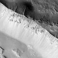
 Wall of Tooting Crater, as seen by HiRISE.
 -
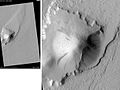
 Pettit Crater rim, as seen by HiRISE.
 -
 Nicholson mound with dark streaks, as seen by HiRISE.
 -
 Lycus Sulci, as seen by HiRISE.
 -
 Streamlined Island in Marte Vallis, as seen by HiRISE.
 -
 Tartarus Colles channel, as seen by HiRISE.
 -
 Channels From Fissure, as seen by HiRISE.
 -
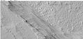
 Narrow ridges, as seen by HiRISE.
 -
 Plateau made up of Medusae Fossae materials and rootless cones, as seen by HiRISE.
 -
 Surfaces in Amazonis quadrangle, as seen by HiRISE.


See also
[edit]Notes and references
[edit]- ^ Tanaka, K.L. (1986). The Stratigraphy of Mars. J. Geophys. Res., Seventeenth Lunar and Planetary Science Conference Part 1, 91(B13), E139–E158.
- ^ Carr, M.H. (2006), The Surface of Mars. Cambridge Planetary Science Series, Cambridge University Press.
- ^ Werner, S. C., and K. L. Tanaka (2011), Redefinition of the crater-density and absolute-age boundaries for the chronostratigraphic system of Mars, Icarus, 215(2), 603–607, doi:10.1016/j.icarus.2011.07.024.
- ^ Horvath, David G.; et al. (2021). "Evidence for geologically recent explosive volcanism in Elysium Planitia, Mars". Icarus. 365 114499. arXiv:2011.05956v1. Bibcode:2021Icar..36514499H. doi:10.1016/j.icarus.2021.114499. S2CID 226299879.
- ^ Martel, Linda M. V. (January 31, 2005). "Recent Activity on Mars: Fire and Ice". Planetary Science Research Discoveries. Retrieved July 11, 2006.
- ^ Irwin, R.P., Tanaka, K.L., and Robbins, S.J., 2013, Distribution of Early, Middle, and Late Noachian cratered surfaces in the Martian highlands: Implications for resurfacing events and processes: Journal of Geophysical Research, v. 118, p. 278–291, doi:10.1002/jgre.20053.
- ^ Laskar, J., Correia, A.C.M., Gastineau, M., Joutel, F., Levrard, B., and Robutel, P., 2004, Long term evolution and chaotic diffusion of the insolation quantities of Mars: Icarus, v. 170, no. 2, p. 343–364, doi:10.1016/j.icarus.2004.04.005.
- ^ Dickson, J.L., Head, J.W., III, and Marchant, D.R., 2010, Kilometer-thick ice accumulation and glaciation in the northern mid-latitudes of Mars: Evidence for crater-filling events in the Late Amazonian at the Phlegra Montes: Earth and Planetary Science Letters, v. 294, no. 3–4, p. 332–342, doi:10.1016/j.epsl.2009.08.031.
- ^ Head, J.W., III, Mustard, J.F., Kreslavsky, M.A., Milliken, R.E., and Marchant, D.R., 2003, Recent ice ages on Mars: Nature, v. 426, p. 797–802.
- ^ Levy, J.S., Head, J.W., III, and Marchant, D.R., 2009, Concentric crater fill in Utopia Planitia: History and interaction between glacial "brain terrain" and periglacial mantle processes: Icarus, v. 202, p. 462–476, doi:10.1016/j.icarus.2009.02.018.
- ^ Fassett, C.I., Dickson, J.L., Head, J.W., III, Levy, J.S., and Marchant, D.R., 2010, Supraglacial and proglacial valleys on Amazonian Mars: Icarus, v. 208, no. 1, p. 86–100, doi:10.1016/j.icarus.2010.02.021.
- ^ Salese, F., G. Di Achille, A. Neesemann, G. G. Ori, and E. Hauber (2016), Hydrological and sedimentary analyses of well-preserved paleofluvial-paleolacustrine systems at Moa Valles, Mars, J. Geophys. Res. Planets, 121, 194–232, doi:10.1002/2015JE004891.
- ^ Leblanc, F., and R. E. Johnson. "Role of molecular species in pickup ion sputtering of the Martian atmosphere." Journal of Geophysical Research: Planets (1991–2012) 107.E2 (2002): 5–1.
- ^ Burr, D.M., Grier, J.A., McEwen, A.S., and Keszthelyi, L.P., 2002, Repeated Aqueous Flooding from the Cerberus Fossae: Evidence for Very Recently Extant, Deep Groundwater on Mars: Icarus, v. 159, no. 1, p. 53–73, doi:10.1006/icar.2002.6921.
- ^ Kolb, Eric J., and Kenneth L. Tanaka. "Geologic history of the polar regions of Mars based on Mars Global Surveyor data: II. Amazonian Period." Icarus 154.1 (2001): 22–39.
- ^ Kieffer, Hugh H., Philip R. Christensen, and Timothy N. Titus. "CO2 jets formed by sublimation beneath translucent slab ice in Mars' seasonal south polar ice cap." Nature 442.7104 (2006): 793–796.
- ^ Balme, Matt, et al. "Transverse aeolian ridges (TARs) on Mars." Geomorphology 101.4 (2008): 703–720.
- ^ Basu, Shabari, Mark I. Richardson, and R. John Wilson. "Simulation of the Martian dust cycle with the GFDL Mars GCM." Journal of Geophysical Research: Planets (1991–2012) 109.E11 (2004).
- ^ Read, Peter L., and Stephen R. Lewis. The Martian climate revisited: Atmosphere and environment of a desert planet. Springer Verlag, 2004.
- ^ Jakosky, Bruce M., and Roger J. Phillips. "Mars' volatile and climate history." nature 412.6843 (2001): 237–244.
- ^ Mangold, N., et al. "A Late Amazonian alteration layer related to local volcanism on Mars." Icarus 207.1 (2010): 265–276.
- ^ Hartmann, William K., and Daniel C. Berman. "Elysium Planitia lava flows: Crater count chronology and geological implications." Journal of Geophysical Research: Planets (1991–2012) 105.E6 (2000): 15011–15025.
- ^ Neukum, Gerhard, et al. "Recent and episodic volcanic and glacial activity on Mars revealed by the High Resolution Stereo Camera." Nature 432.7020 (2004): 971–979.
- ^ Márquez, Álvaro, et al. "New evidence for a volcanically, tectonically, and climatically active Mars." Icarus 172.2 (2004): 573–581.
- ^ Mueller, Karl, and Matthew Golombek. "Compressional structures on Mars." Annu. Rev. Earth Planet. Sci. 32 (2004): 435–464.
- ^ Robbins, Stuart J., and Brian M. Hynek. "Distant secondary craters from Lyot crater, Mars, and implications for surface ages of planetary bodies." Geophysical Research Letters 38.5 (2011).
- ^ Malin, Michael C., et al. "Present-day impact cratering rate and contemporary gully activity on Mars." science 314.5805 (2006): 1573–1577.
- ^ Popova, Olga, Ivan Nemtchinov, and William K. Hartmann. "Bolides in the present and past Martian atmosphere and effects on cratering processes." Meteoritics & Planetary Science 38.6 (2003): 905–925.
- ^ International Commission on Stratigraphy. "International Stratigraphic Chart" (PDF). Retrieved September 25, 2009.
- ^ a b Eicher, D.L.; McAlester, A.L. (1980).History of the Earth; Prentice-Hall: Englewood Cliffs, NJ, pp 143–146, ISBN 0-13-390047-9.
- ^ Masson, P.; Carr, M.H.; Costard, F.; Greeley, R.; Hauber, E.; Jaumann, R. (2001). Geomorphologic Evidence for Liquid Water. Space Science Reviews, 96, p. 352.
- ^ Nimmo, F.; Tanaka, K. (2005). Early Crustal Evolution of Mars. Annu. Rev. Earth Planet. Sci., 33, 133–161.
- ^ Hartmann, W.K.; Neukum, G. (2001). Cratering Chronology and Evolution of Mars. In Chronology and Evolution of Mars, Kallenbach, R. et al. Eds., Space Science Reviews, 96: 105–164.
Bibliography and recommended reading
[edit]- Boyce, Joseph, M. (2008). The Smithsonian Book of Mars; Konecky & Konecky: Old Saybrook, CT, ISBN 978-1-58834-074-0
- Carr, Michael, H. (2006). The Surface of Mars; Cambridge University Press: Cambridge, UK, ISBN 978-0-521-87201-0.
- Hartmann, William, K. (2003). A Traveler's Guide to Mars: The Mysterious Landscapes of the Red Planet; Workman: New York, ISBN 0-7611-2606-6.
- Morton, Oliver (2003). Mapping Mars: Science, Imagination, and the Birth of a World; Picador: New York, ISBN 0-312-42261-X.