Hubbry Logo
AnegadaAnegadaMain
Open search
Anegada
Community hub
Anegada
logo
8 pages, 0 posts
0 subscribers
Be the first to start a discussion here.
Anegada
Anegada
from Wikipedia

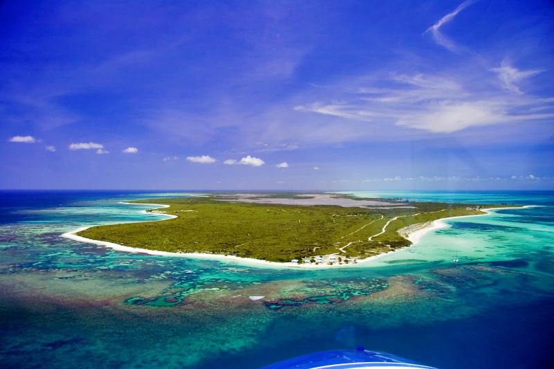
Anegada /ˌænəˈɡɑːdə/ is the northernmost of the British Virgin Islands (BVI), a group of islands that form part of the archipelago of the Virgin Islands. It lies about 15 miles (24 km) north of Virgin Gorda. Anegada is the only inhabited British Virgin Island formed from coral and limestone,[2] rather than of volcanic origin. While the other islands are mountainous, Anegada is flat and low. Its highest point is only about 28 feet (8.5 m) above sea level, earning it its name, which is from the Spanish for "flooded land", tierra anegada.[3]

Key Information

Additionally, Anegada is the only sliver of land directly south of Bermuda, another British overseas territory. Anegada lies directly west of Mauritania in Africa and east of all other islands in the British Virgin Islands.

At about 15 square miles (38 square kilometers), Anegada is the second-largest of the British Virgin Islands. With a population of 450 as of the 2024 census.[4] Most of Anegada's residents live in the only village, The Settlement.

Economy

[edit]
Horseshoe Reef extends southeastward from Anegada

The primary business of Anegada is tourism. On a typical day during the tourist season, the island has 200 to 300 visitors. Commercial fishing is also a substantial business on Anegada, with local fishermen providing most of the fresh fish and lobster catch for the rest of the British Virgin Islands. Its miles of south shore flats have a large population of bonefish, making Anegada a popular destination for fly fishing.

From 2008 to 2013 Anegada was home to one of the tallest Christmas trees in the Caribbean and had an official tree lighting ceremony and party each year.[5] The tree, donated by Adrian Johnson, was intended to help bring visitors to the island and provided a flotilla destination for many sailors.

Access

[edit]

Access to the island is via the small Auguste George Airport (NGD), thrice-weekly ferries, and private boat. Charter flights run directly to Anegada from Tortola, Virgin Gorda, San Juan, St. Thomas, Antigua, and St. Maarten.[6][check quotation syntax]

Horseshoe Reef

[edit]

Anegada is known for miles of white sand beaches and the 18-mile (29 km)-long Horseshoe Reef, one of the Caribbean's largest barrier coral reefs. The reef makes navigation to Anegada difficult. While charter boats freely sail among most of the other Virgin Islands, charter companies often forbid clients to sail to Anegada to avoid running aground on the reef.

The reef has caused hundreds of shipwrecks,[7] including HMS Astraea in 1808,[8] the Donna Paula (1819), and the MS Rocus (1929).[9] As such, it was once an important scuba diving destination. In an effort to protect the reef, the BVI government has made anchoring on Horseshoe Reef illegal.

Fauna

[edit]

Anegada is also known for the large salt ponds that cover much of its west end. These ponds, which support unique fauna, were designated a Ramsar Site on 11 May 1999. In the 1830s, thousands of Caribbean flamingos lived in these ponds, but they were hunted for food and feathers throughout the 19th and early 20th centuries and disappeared by 1950. They have since been re-established. As of 2016, the flamingo flock numbers approximately 200. The birds are another tourist draw, but officials are trying to keep the number of visitors to the flamingo areas at a level that allows the birds to flourish. BirdLife International has recognized the western salt ponds and south-eastern coastal mangroves as an Important Bird Area (IBA).[10]

Other rare or endangered animals include the Anegada rock iguana (Cyclura pinguis) and several species of turtle. Conch, Caribbean lobster (Metanephrops binghami), and many species of fish can be found near Anegada, particularly in the deep waters off the North Drop, north of the island.

The Ft. Worth Zoo now maintains an Anegada Rock "Headstart" facility in the Settlement. Newly hatched iguanas are caught in the wild, brought to the facility, and raised until they are large enough to defend themselves against the feral cats that are their only predator on Anegada. As of 2016, over 200 iguanas have been released from the Headstart program back into the wild. In addition, an annual Iguana Festival is held outside the Iguana Headstart Facility to celebrate the island's native species.

The reef adjacent to the Settlement was once one of the Caribbean's more fertile conch grounds, but overfishing has wiped out its conch population. Visitors to the Settlement are greeted by the sight of mountains of empty conch shells on the shore.[11]

There are also populations of feral cattle, donkeys, goats, cows, and sheep that live in all areas of the island.

Hurricanes

[edit]

Anegadians traditionally endured hurricanes by tying their dories to the trunks of mangroves with rope and covering them with tarps. Today, given sufficient warning, a few leave the island for Tortola until the storm passes.

On 30 August 2010, the eye of Hurricane Earl passed 15 to 20 miles (24 to 32 km) north of Anegada at category 4, with winds in excess of 135 mph (60 m/s). The close passage led to significant damage on the island, with major flooding on the south side from the storm surge and breaking waves. The north side experienced no storm surge, and Horseshoe Reef protected it from breaking waves. 24 hours before the storm arrived, the forecast was for the storm to pass well to the north. By the time it was apparent that the hurricane was going to have a major impact, all transportation services from Anegada (air and ferry) had been suspended. There were no reported serious injuries on the island.[12][13]

On 6 September 2017, the eye of Hurricane Irma passed 12 miles (19 km) south of Anegada at category 5, with winds in excess of 185 mph (83 m/s). Irma's northern eyewall passed directly over Anegada, causing major damage to the island. Some people evacuated to Tortola before the storm struck, but most people remained on the island. There was some flooding on the south side from the storm surge and breaking waves. The north side experienced no storm surge, and Horseshoe Reef protected it from breaking waves. There were no reported serious injuries on the island.[14]

Education

[edit]

About 70 students attend school at the Claudia Creque Educational Centre,[citation needed] formerly Anegada Primary and Secondary School.[15] This self-contained school is the only school on Anegada and handles pre-school, primary, and secondary levels. It is funded and operated by the British Virgin Islands government.

See also

[edit]

Further reading

[edit]

References

[edit]
[edit]
Revisions and contributorsEdit on WikipediaRead on Wikipedia
from Grokipedia
Anegada is the northernmost island of the (BVI), a British Overseas Territory in the northeastern , and the only coral atoll in an otherwise composed of volcanic islands.
Measuring approximately 15 square miles (39 km²) in area, with a maximum elevation of just 28 feet (8.5 m) above , the island's flat, low-lying —often obscured by the horizon—earned it the Spanish name Anegada, meaning "submerged" or "drowned land." Surrounded by the Horseshoe Reef, the largest barrier in the eastern at 18 miles (29 km) long, Anegada features 16 miles of pristine, white-sand beaches, extensive salt ponds, and mangrove wetlands that cover about half its surface.
Home to a small of approximately 450 residents (2024 est.), mostly concentrated in the main village of The Settlement, Anegada remains one of the most remote and least developed islands in the BVI, accessible primarily by ferry from (14 miles away) or small aircraft. The local economy centers on —a key export—and sustainable , drawing visitors for world-class and amid over 200 historic shipwrecks, as well as and beach relaxation at sites like Loblolly Bay and Cow Wreck Beach. Limited and salt production supplement livelihoods, though the island's nutrient-poor soils and low rainfall constrain large-scale farming. Evidence of pre-Columbian presence dates back over 800 years, marked by ancient shell middens, while European colonization in the 17th–18th centuries focused on plantations, salvage from the treacherous reefs, and salt extraction using enslaved labor. Today, Anegada is renowned for its biodiversity, including the critically endangered endemic Anegada ground iguana (Cyclura pinguis), over 100 bird species such as reintroduced Caribbean flamingos, and vital marine habitats supporting hawksbill and queen within protected areas like the Horseshoe Reef Fisheries Protected Area. Its fragile ecosystems face threats from , , and pressures, underscoring ongoing conservation efforts by organizations like the BVI National Parks Trust.

Geography

Location and geology

Anegada is situated in the northeastern as the northernmost island of the (BVI), forming part of the Puerto Rico Bank and positioned at the extreme northeastern edge of this shallow underwater platform. Its geographic coordinates are approximately 18°44′ N, 64°20′ W, placing it about 24 km north of and 33 km northeast of , the largest BVI island. As the northernmost of the archipelago, Anegada lies within the hurricane belt, separated from the open Atlantic by extensive reef systems and from the deeper to the north by a steep underwater slope. Geologically, Anegada stands out as the only in the BVI's predominantly volcanic chain, having formed as a submerged barrier system during the epoch, approximately 100,000 to 130,000 years ago. It consists of a flat platform composed primarily of coral-derived sediments, bioclastic sands, and marine-origin overlaying older igneous and metamorphic foundations typical of the Platform. The island's total area measures 38 km² (15 sq mi), with a maximum elevation of just 8.5 meters (28 ft) above , reached in the northeastern region near the airport. This low profile, earning it the Spanish name "Anegada" meaning "flooded" or "submerged land," reflects its emergence from shallow marine waters and vulnerability to inundation. The island's topography is characteristically flat and low-lying, contrasting sharply with the rugged, volcanic terrain of neighboring BVI islands like and . It features a division into an eastern limestone plain and a western dune and sand ridge formation, interspersed with wetlands, solution holes, and minimal elevation changes that facilitate water percolation and historical flooding. Surrounding the island are extensive coral reefs, including the prominent Horseshoe Reef to the southeast—the largest barrier coral reef in the eastern at 29 km (18 miles) long—which contributes to its isolation and shapes its coastal morphology. Historical fieldstone walls, constructed from local coral and , delineate about one-third of the island as a traditional agricultural zone.

Climate

Anegada experiences a moderated by persistent , which blow predominantly from the east-northeast direction and average 12–30 km/h (7–12 mph) during peak periods from June to July, dropping to around 7 km/h (4 mph) in October. These winds contribute to consistently warm conditions, with annual average high temperatures of 28.7°C (83.6°F) and lows of 21.4°C (70.6°F), based on proxy data from nearby ; summer highs reach approximately 32°C (89.6°F), while winter lows dip to about 21°C (69.8°F). Overall, the climate is hot and dry, characterized by high year-round rates driven by elevated temperatures and constant breezes, which exceed in many months and stress local . The island has distinct seasonal patterns, including a from to April—when February and March are the driest months—and a rainy season from May to , with peak occurring from late September to . Annual rainfall averages approximately 125 cm (49 inches), similar to the ' overall average of 115 cm due to Anegada's flatter and exposure to . These conditions, combined with the island's saline wetlands, support seasonal bird migrations, particularly during the wetter periods when habitats become more hospitable. The Atlantic hurricane season influences the region from to October, bringing potential for increased rainfall and storms, though often temper daily weather. Anegada's low elevation, with 40% of the land below 3–4 meters and a maximum height of 8.5 meters, heightens its vulnerability to —projected at 0.19–0.58 meters by 2100—and associated effects, amplifying flood risks and altering hydrological balances as noted in geological descriptions. This topography exacerbates impacts on wetlands, such as Flamingo Pond and the Western Salt Ponds, through recurrent inundation, , and heightened salinization during wet seasons or storm events. Beaches, including those along the northwest coast at Keel Point and West End Point, face accelerated from wave action and reduced retention, threatening coastal stability and habitats.

History

Pre-colonial and early settlement

Archaeological evidence indicates that Amerindians, including and Carib peoples, visited Anegada seasonally during the pre-colonial period, utilizing its abundant marine resources for fishing and shellfish gathering. from conch shell middens places this activity around AD 1245 ± 80, with artifacts such as Elenoid-series pottery shards, shell adzes, and fish bones suggesting temporary camps rather than permanent villages. These middens, located at sites like Anegada I near Budrock Pond and Anegada II near The Settlement, highlight exploitation of , , and possibly salt production, but the island's poor soils, low rainfall, and vulnerability to storms and tsunamis limited sustained habitation. No evidence of large-scale or year-round settlements has been found, pointing to sporadic use by groups from nearby islands in the archipelago. European contact with Anegada began in the early during Spanish exploration of the , with the island first appearing on maps around 1523, earning its Spanish name Anegada, meaning "flooded" or "drowned land," due to its low elevation often obscured by the horizon. The surrounding posed immediate navigational dangers, leading to the first recorded shipwrecks that year when two Spanish merchant naos ran aground, marking the start of over 200 documented wrecks in the area through the . These hazards, exacerbated by the reef's extension up to 17 miles offshore, resulted in significant losses for Spanish, Dutch, and later British vessels, with salvage activities becoming an early economic draw. The Spanish claimed the by discovery but made no attempts to settle Anegada, leaving it largely uninhabited amid broader regional colonization efforts. British interest in Anegada grew in the mid-17th century as part of the , with formal claims established in 1672 following the English capture of from the Dutch, incorporating Anegada and into the territory. Despite this, permanent settlement remained sparse until the 1780s, when small groups of English and African-descended settlers arrived, drawn by opportunities in shipwreck salvage, salt production, and resource extraction. By 1815, the population numbered around 141, including enslaved individuals, who developed self-sufficient communities centered on —yielding over 154,000 pounds annually—and limited agriculture, such as planting on the island's thin soils. These early inhabitants lived in wooden structures adapted to frequent hurricanes, relying on the reef's fisheries and small gardens for sustenance while avoiding the environmental constraints that had deterred prior habitation.

Colonial period and modern developments

Anegada was annexed by the British Crown in 1680 as part of the broader acquisition of the , following the capture of from the Dutch in 1672. The island formed part of the Colony from until 1956, during which British colonial administration emphasized limited settlement due to Anegada's challenging terrain of salt flats and thin soils. The local relied on small-scale , including modest plantations of crops like corn and sweet potatoes, alongside and salt production from the island's ponds, which supported a sparse of tenant farmers under a semi-feudal system. A pivotal event in the colonial era was the "Great March" of November 24, 1949, led by Anegada fisherman Theodolph H. Faulkner alongside Isaac G. Fonseca and Carlton L. de Castro. This demonstration, involving around 1,500 residents from across the , protested discriminatory colonial policies, including inadequate healthcare, lack of political representation, and exploitative land tenure practices that left many Anegadians as tenants without secure rights. The march catalyzed reforms, contributing to the push for greater and influencing subsequent land policies on Anegada. In the mid-20th century, Anegada saw brief involvement in international projects, including the construction of a U.S. tracking station at West End Point in the 1950s to monitor early space launches from , such as the 1962 Mercury mission Aurora 7. The station operated until the 1980s before being abandoned, leaving behind concrete structures. Meanwhile, the , including Anegada, achieved self-governing status as a under a new constitution in 1967, shifting administrative control toward local institutions while retaining British oversight for defense and foreign affairs. Efforts to modernize Anegada's included the 1961 Anegada Ordinance, which designated The Settlement— the island's primary community—as a reserved area of approximately 357 acres for resident use, granting limited ownership rights to occupants and addressing long-standing tenure insecurities. However, ambitious development proposals, such as British entrepreneur ' 1967 plan for the Anegada Development Corporation to build an airstrip, , and housing for up to 20,000 new residents on a 199-year lease, faced strong local opposition over fears of displacement and environmental harm, ultimately failing to materialize. Tourism emerged as a key driver of change from the onward, with the opening of the Anegada Reef Hotel in by local owners Lowell and Vivian Wheatley marking the start of organized visitor accommodations and boosting the island's profile for its beaches and . This growth helped diversify the economy beyond traditional fishing, though it remained modest to preserve Anegada's remote character. In recent years, Anegada's has stabilized at around 300 residents, reflecting limited migration and a focus on . Renewable energy initiatives gained momentum following 2013 proposals in the Electricity Corporation's power development plan, leading to the 2021 contract for a 1.25-megawatt solar photovoltaic array and battery storage system at West End; groundbreaking occurred in 2022, with commissioning expected in late 2025 following delays, to reduce reliance on diesel and support the island's grid. As of August 2025, the project is advancing toward supplying 90% of the island's power needs, marking a step toward the BVI's 60% mandate by 2030.

Demographics and society

Population and settlements

Anegada has an estimated population of approximately 350 residents as of 2024. This figure represents a modest increase from the 285 recorded in the 2010 census, reflecting the island's small and stable demographic amid its remote location. The community exhibits an aging profile, with a 2012 survey of residents indicating 47% aged 31–54 and another 47% aged 55 or older, alongside only 6% aged 30 or younger. Gender distribution in the same survey showed 60% male and 40% female respondents, while birthplace data revealed that 33% were born on Anegada specifically, with 66% originating from Anegada or elsewhere in the . The population has historically been migratory, with significant and return patterns influencing community composition. The primary settlement is The Settlement, the island's only formal village, which houses about 90% of the population and serves as the central hub for daily life and services. Located near coastal wetlands, it features around 50 structures documented in a 2012 architectural survey, including traditional board-and-shingle homes with foundations and galvanized roofs, though some are derelict or maintained as empty family properties. Beyond The Settlement, residents occupy scattered homes in areas such as Setting Point, Nutmeg Point, Loblolly Bay, and near beaches and salt ponds, often tied to family and access. Social dynamics in Anegada are shaped by ongoing concerns over land ownership, with 94% of 2012 survey respondents identifying uncertainty in as a very important issue, stemming from historical designations and unresolved allocation claims. The community, comprising families like the Faulkners, Whites, and Smiths, relies heavily on local jobs in and , fostering a tight-knit, resilient social fabric despite external migration pressures.

Education and culture

Anegada's educational landscape is anchored by the Claudia Creque Educational Centre, the island's sole public school located in The Settlement, which provides comprehensive instruction from pre-school through secondary levels and serves approximately 70 students. Operated and funded by the British Virgin Islands' Ministry of Education and Culture, the centre emphasizes foundational skills alongside practical community needs, including recent enhancements like classroom cooling systems to support learning in the tropical climate. Community engagement is strong, with initiatives such as reading weeks and marine safety workshops fostering student involvement and parental participation. A key aspect of on Anegada is the integration of environmental , reflecting the island's ecological vulnerabilities. A 2012 community survey conducted as part of the Anegada Environmental Profile revealed unanimous support—100% of respondents—among residents for expanding in schools and the broader community, highlighting priorities like fisheries conservation and habitat protection. This aligns with broader efforts by the Department of Conservation and Fisheries to incorporate topics into curricula, such as turtle nesting and management, to build eco-conscious values from an early age. Anegada's culture embodies a rich fusion of African, European, and indigenous influences, shaped by the ' historical migrations and colonial past, evident in daily practices and communal bonds. Traditions rooted in —central to the island's economy and identity—intertwine with sessions that preserve generational knowledge, often shared during family gatherings or informal beachside talks. Annual events like the Anegada Lobster Festival, held in late November, celebrate this heritage through culinary showcases of local , music, and dances, drawing residents and visitors to honor sustainable harvesting practices while reinforcing community ties. Due to Anegada's small population and remote location, formal cultural institutions remain limited, with preservation relying on efforts and oral histories rather than dedicated museums or theaters. These narratives, passed down through elders, vividly recount shipwrecks on the surrounding Horseshoe Reef—more than 200 shipwrecks—and devastating hurricanes, embedding lessons of resilience and into the collective identity. further sustains this heritage, with traditional stone-walled homes and wooden structures in The Settlement exemplifying adaptive, low-impact building techniques that echo indigenous and early settler ingenuity while promoting cultural continuity.

Government and economy

Administration and land use

Anegada forms part of the (BVI), a British Overseas Territory administered by the , where the represents the British monarch and oversees defense, foreign affairs, internal security, and the public service, while the locally elected and House of Assembly manage domestic affairs. The island operates as one of the BVI's four administrative districts, with essential services such as healthcare, , and utilities integrated through the central government in , , though delivery is often challenged by Anegada's remote location and limited infrastructure. Local governance involves the Anegada District Office, housed in the Anegada Administration Complex, which facilitates community decisions on issues like and minor infrastructure via an advisory committee, but the island currently shares the 9th representation with , prompting ongoing calls for dedicated district status to better address unique needs. Historically treated as used rent-free by inhabitants, Anegada's approximately 15,000 acres transitioned to predominantly following the 1961 Anegada Ordinance (Cap. 146), which vested most property in , designated The Settlement for resident plots of 0.5-1 acre, and reserved areas for cultivation, , and roads, while prohibiting sales and directing lease proceeds to a local account. This designation sparked contentious ownership disputes, including the failed 1967 Bates lease of 8,092 acres for 199 years (canceled in 1971), leading to bitterness over unfulfilled promises and unresolved claims marked by traditional stone walls, with regularization efforts like the 1987 Renwick Report and 2007 Lands Allocation Plan delayed by tenure uncertainties and, more recently as of 2025, additional scrutiny from the 2021 Commission of Inquiry into BVI . In a 2012 community survey, 94% of respondents identified land ownership uncertainty as a primary concern, exacerbating reluctance to invest and straining relations with the ; similar issues persisted into 2025, with residents awaiting promised land titles amid government assurances that distribution remains forthcoming. Land use regulations emphasize environmental preservation amid development pressures, governed by the Physical Planning Act (2004), which mandates Environmental Impact Assessments for major projects, and the National Physical Development Plan (2006), prioritizing small-scale, gradual growth in zones for residential, commercial, and agricultural activities while restricting alterations in sensitive coastal and wetland areas. Crown Land leasing, limited to Belongers (BVI citizens), allows 50-99 years for commercial uses and up to 5 years (renewable) for agriculture, with resale profits capped at 25% to prevent speculation, balancing conservation—such as through proposed turtle nesting beach protections—with limited infrastructure like solar farms and community parks. Unique to Anegada, proposals for UNESCO Biosphere Reserve status aim to integrate these elements, fostering sustainable livelihoods while safeguarding ecosystems like the Western Salt Ponds Ramsar site, though implementation remains pending.

Economic sectors

Anegada's economy centers on as a primary industry, with commercial activities focusing on such as , , , , snapper, and curry-mole mullet, often serving both local markets and demands. These fisheries have historically supported self-sufficiency, but , habitat degradation, and unsustainable practices like the use of monofilament nets and wire traps have led to significant depletion concerns, including for queen populations, where local fishermen have called for a 5- to 10-year ban to allow recovery. Reefs around the island are described as virtually fished out, with 81% of community members in a 2012 survey identifying marine reductions as a critical issue and 69% attributing it to pressures. Approximately 17% of the workforce was engaged full- or part-time in in 2012, though self-identification as fishermen reached up to 40% among respondents, reflecting its integral role in the local economy. As of 2025, remains key within the BVI's initiatives promoting sustainable and marine resources. Tourism provides essential support through small-scale accommodations and services, with growth accelerating since the 1970s as visitors sought the island's tranquil beaches, reefs, and watersports, including sport fishing for . Establishments like Neptune’s Treasure and the Anegada Reef Hotel exemplify this low-key approach, catering primarily to charter boat guests via restaurants and bars, while comprising about 22% of the 2012 workforce. Sustainability efforts include proposals for solar farms in 2013 to power and reduce reliance on diesel, aligning with community priorities for eco-tourism, which garnered 75% support in surveys. Access by and small has facilitated economic visitors, bolstering these services without overwhelming the island's scale; tourism continued to drive BVI economic recovery in 2024-2025, with record visitor numbers supporting Anegada's sector. Other sectors remain limited, with agriculture confined to small-scale livestock rearing of cattle, goats, sheep, and donkeys, supplemented by minor crops like pumpkins and melons, amid challenges from free-roaming animals and poor soils. Historically, Anegada achieved self-sufficiency through , , and salvaging shipwrecks until the mid-20th century, but post-World War II shifts toward a service-based increased imports and diversified income sources. Community opposition to large resorts was strong, with 70% rejecting such developments in a survey to preserve the island's character, favoring instead guesthouses and eco-initiatives at 75% approval.

Tourism

Access and transportation

Anegada's primary air access is through Captain Auguste George Airport (NGD), a small facility handling . Charter flights are available from , , San Juan, St. Thomas, , and St. Maarten through operators like , Island Birds, and Fly BVI. Sea travel provides the most common route to the island, with ferries departing from on and stops at , operated by Smith's Ferry Service on Mondays, Wednesdays, Fridays, and Sundays, with a journey time of approximately 2.5 hours. Island infrastructure supports limited ground transport, featuring a sparse network of unpaved and gravel roads totaling about 20 miles that link the main settlement, , and coastal areas. No public bus system exists, so visitors depend on on-demand taxis—readily available at Setting Point ferry dock and —or rentals of jeeps, scooters, and bicycles for exploration. In peak tourist season (December to April), Anegada accommodates roughly 200–300 daily visitors to maintain its low-impact character.

Key attractions

Anegada's key attractions revolve around its pristine beaches, eco-friendly pursuits, and distinctive culinary traditions, offering a serene contrast to the rugged, mountainous of the other . As the only in the , its flat landscape and surrounding reefs provide an unspoiled setting for relaxation and exploration. The island's beaches, such as Loblolly Bay and Cow Wreck Beach, draw visitors for their powdery white sands, clear turquoise waters, and opportunities for and lounging. Loblolly Bay, often ranked among the world's top beaches, features crystal-clear waters ideal for swimming and relaxation under shaded umbrellas, with a beach bar offering refreshments. Cow Wreck Beach, known for its vibrant waters and secluded vibe, serves as a prime spot for amid formations and for unwinding on quiet shores. These areas also support recreational activities like for in the shallow flats, a pursuit that highlights the island's abundant without requiring advanced equipment. Hiking trails, such as the nature path at Bones Bight through open grasslands, allow visitors to traverse the island's low-lying while enjoying panoramic views of the . Eco-tourism experiences emphasize Anegada's natural and historical features, including visits to the salt ponds for . These inland ponds, particularly around Flamingo Pond, host migratory birds and resident flamingos, accessible via lookout towers for observation. Maritime archaeology enthusiasts can join tours to explore historic shipwrecks, remnants of Spanish galleons and British vessels scattered along the reefs, providing insights into the island's seafaring past. Small-scale guesthouses in The Settlement offer intimate, community-oriented stays that align with practices. Unique to Anegada are its lobster feasts, a culinary highlight featuring fresh, locally caught prepared in various dishes at beachside spots. This tradition culminates in the annual Anegada Lobster Festival, a three-day event in late celebrating the island's fishing heritage with music, food stalls, and cultural activities. These attractions underscore Anegada's appeal as a low-key destination for sustainable, nature-based recreation.

Ecology

Flora and vegetation

Anegada's flora is characterized by a diverse array of adapted to its arid, environment, with approximately 332 species recorded in total, of which 228 are native. Among these, three species are endemic to the island, including the critically endangered tree Vachellia anegadensis (known locally as pokewood), which grows up to 8 meters tall and is distributed across much of Anegada but faces ongoing population declines due to habitat loss. Another endemic is the rare palm Sabal causiarum, with an estimated population of around 200 individuals, primarily seedlings, occurring in sheltered dune areas on the island's west end. Additionally, 65 "belonger" plant species—those native or regionally significant and well-adapted to the dry, saline conditions—play a key role in the island's ecological identity, including 24 endangered, 7 threatened, and 12 vulnerable taxa. The island's vegetation is dominated by several distinct types shaped by its low elevation, seasonal droughts, and coastal influences. Native grasslands, featuring species like Uniola virgata, cover coastal and central areas but are often degraded. Drought-deciduous woodlands, comprising over 75% species such as thorny shrubs and small trees, prevail in the interior and eastern regions, including the Limestone Plain east of Bumber Well Pond. communities, including red (Rhizophora mangle), white, and buttonwood species, form low woodlands along the southeastern shoreline and coasts, while seagrass beds—such as turtle grass (), manatee grass (Syringodium filiforme), and shoal grass (Halodule wrightii)—thrive in shallow marine areas, particularly on the south side. Anegada's wetlands, encompassing salt ponds like Flamingo Pond and the extensive Western and Eastern Ponds, represent the largest such systems in the , covering about half the island and supporting specialized halophytic vegetation. Significant threats to Anegada's flora include , feral , and human development. The Australian pine (), a widespread non-native , aggressively outcompetes native across grasslands, woodlands, and coastal zones, altering habitats and reducing . Feral , including cattle, goats, sheep, and donkeys, cause and soil trampling, severely impacting grasslands, woodlands, and wetlands. Development pressures, such as road construction, expansion, and coastal clearing, further degrade habitats, with surveys indicating that 63-75% of local stakeholders identify these as primary concerns for plant communities. Conservation measures, including the designation of protected areas like the 1,071-hectare Western Ponds and the Eastern Ponds, aim to mitigate these threats through habitat restoration, removal, and monitoring of endemic .

Fauna and conservation

Anegada's fauna is characterized by a mix of endemic, migratory, and , with significant in its wetlands, beaches, and coastal habitats. The island supports approximately 109 bird , including migratory shorebirds and resident seabirds that utilize the saline ponds and mangroves. Among mammals, two bat are recorded: the Jamaican fruit bat (Artibeus jamaicensis) and the velvety (Molossus molossus), both of which roost in limited cave and building sites. Reptilian highlights include the critically endangered Anegada rock iguana (Cyclura pinguis), with an estimated wild population of 300–600 individuals as of the early 2020s. Marine encompass sea turtles such as the endangered green (Chelonia mydas), hawksbill (Eretmochelys imbricata), and leatherback (Dermochelys coriacea), with fewer than 10 nesting females observed annually as of the mid-2000s across the island's beaches. The queen conch (Lobatus gigas) population is depleted due to historical overharvesting, as evidenced by large shell middens from pre-Columbian and colonial eras. Over 180 of reef-associated fish contribute to the island's marine diversity, though specific counts vary by survey. Several are now extinct or locally extirpated, including the West Indian whistling duck (Dendrocygna arborea) and the (Neomonachus tropicalis). Conservation efforts on Anegada focus on protecting these through designated and targeted recovery programs. The Western Salt Ponds, a Ramsar site of international importance spanning 1,071 hectares, was established in 1999 to safeguard tidal mudflats, mangroves, and saline lagoons that serve as critical habitats for , iguanas, and fish like mullet (Mugil cephalus). Flamingo Pond, designated as a sanctuary in 1977 covering 220 hectares, supports reintroduced populations of greater flamingos (Phoenicopterus ruber). The Horseshoe Reef Fisheries , implemented in 2003, encompasses marine environments to regulate and protect aquatic species, including and . A , developed under the Darwin Initiative from 2003 to 2006, assessed coastal ecosystems and prioritized recovery, leading to enhanced monitoring and habitat management. Key recovery initiatives include the headstart program for the Anegada rock iguana, initiated in 1997 by the National Parks Trust in collaboration with the ; over 200 juveniles have been released into the wild since its inception, with more than 160 since 2003 alone, boosting survival rates through captive rearing and predator protection. The reintroduction, started in 1992 with 22 birds sourced from and released into local ponds, has grown the population to approximately 433 individuals observed in 2022, primarily at Flamingo Pond, through ongoing monitoring and anti-poaching measures by the National Parks Trust. conservation adheres to the 1959 Turtles Ordinance, which prohibits nesting disturbances, while proposed initiatives like the Anegada Conch Restoration aim to address queen conch depletion via sustainable harvesting quotas. Community education programs enjoy near-universal support, with 100% of surveyed residents endorsing conservation actions in 2012 assessments. Major threats to Anegada's fauna include , which has reduced stocks of , turtles, and finfish; such as rats ( spp.), feral cats, and lionfish (Pterois volitans), which prey on eggs and juveniles; free-roaming livestock like and that degrade ; and from coastal development. Hurricanes Irma and Maria in 2017 caused significant damage to wetlands and mangroves, with recovery efforts ongoing as of 2023. These pressures are exacerbated by climate change impacts on wetlands, prompting ongoing efforts like eradication trials and restoration within Ramsar sites to ensure long-term resilience.

Natural history and hazards

Horseshoe Reef and marine features

Horseshoe Reef is a barrier that encircles much of Anegada, extending approximately 18 miles (29 km) in length and recognized as one of the largest in the . This expansive structure, shaped like a horseshoe, lies just beneath the surface and has historically posed significant navigational challenges due to its shallow depths and proximity to major shipping routes through the Anegada Passage. The ancient Horseshoe Reef, dated to over 125,000 years old, surrounds much of Anegada. The reef's treacherous nature has led to numerous shipwrecks over centuries, with records indicating hundreds of vessels lost since the , including the British HMS Astraea in 1808. The Astraea, a 32-gun ship en route from to , struck the reef amid poor visibility, resulting in the loss of four crew members and most of its cargo; remnants of the wreck, including cannons, remain embedded in the coral today. Other notable incidents include the Donna Paula in 1819 and the MS Rocus freighter in 1929, underscoring the reef's role as a maritime hazard that has claimed hundreds of ships over the centuries. These wrecks highlight the reef's historical significance and offer potential for , with artifacts occasionally surfacing to support educational tourism initiatives on Anegada. Ecologically, Horseshoe Reef supports a vibrant , harboring diverse populations with surveys documenting an average of 52 per site, including , groupers, and snappers. Designated as a Fisheries Protected Area under the Fisheries Regulations of 2003, the reef spans key zones southeast of Anegada to safeguard habitats for commercially important like and . To preserve this , anchoring within the reef is prohibited, ensuring minimal disturbance to the coral structures and associated .

Hurricanes and other risks

Anegada lies within the Atlantic hurricane belt, where the season typically peaks from to , increasing the island's exposure to intense tropical cyclones. , a Category 4 , passed near Anegada in 1960, with its eye approximately 15 km to the south of the island and generating counterclockwise winds from the north that caused significant overwash and coastal alterations through and deposition. In August 2010, Hurricane Earl, also a Category 4, passed approximately 30 km north of Anegada, leading to widespread flooding and wrack deposition along the shores, though effects were less severe than direct hits. Hurricane Irma, a Category 5, devastated Anegada in September 2017 as its eyewall crossed the island, producing winds exceeding 170 mph and a storm surge reaching 3.8 m above sea level on the north shore, resulting in major structural damage but no serious injuries. Beyond hurricanes, Anegada faces , particularly along its low-lying shores, exacerbated by storm surges that rework sediments and narrow beaches. Sea level rise poses a growing threat, contributing to increased flooding and inundation risks for the island's fringing reefs and low-elevation areas. Geological evidence indicates past tsunamis affecting Anegada, including coral boulders deposited between AD 1200–1450 and overwash deposits from 1650–1800, likely from seismic activity near the . Wetland degradation, driven by development and climate stressors, diminishes natural buffers against flooding in Anegada's salt ponds and mangroves. Marine debris and , including plastics accumulating on eastern shores, further strain the island's coastal ecosystems through ongoing challenges. These hazards have caused recurrent flooding, especially on Anegada's south side during storms, threatening like docks and homes as well as ecological features such as wetlands. In response to recent events like Irma, has been bolstered through initiatives such as retrofitted emergency shelters and local teams, aiding rapid recovery and hazard mitigation.

References

Add your contribution
Related Hubs
User Avatar
No comments yet.