Ardwick
View on Wikipedia
Ardwick is an area of Manchester, England, one mile (1.5 kilometres) southeast of the city centre. The population at the 2011 census was 19,250.[1]
Key Information


Historically in Lancashire, by the mid-nineteenth century Ardwick had grown from being a village into a pleasant and wealthy suburb of Manchester, but by the end of that century became heavily industrialised.[2][3] When its industries fell into decline so did Ardwick, becoming one of the city's most deprived areas. Substantial development has since taken place, including the construction of facilities for the 2002 Commonwealth Games at the nearby City of Manchester Stadium.
In the late nineteenth century, Ardwick had many places of entertainment, but the only remnant of that today is the Art Deco-style Manchester Apollo, a venue for pop and rock music concerts.[3]
History
[edit]Before the Industrial Revolution, Ardwick was a small village just outside Manchester in open countryside. The principal residents were the Birch family, one of whom was a major general when Oliver Cromwell (briefly) instituted direct military rule.
One Samuel Birch was instrumental in providing a small chapel of ease, dedicated to St. Thomas, and consecrated in 1741. This soon expanded into a Georgian church, to which a brick campanile was added in 1836.[4] It contained a very rare Samuel Green organ, installed in 1787 or 1788, the first in which the sharp keys were distinguished in black. When the building ceased to be used as a church in 1978, the organ was rescued by an organ builder called George Sixsmith, and installed in St Paul's Church, Pendleton.[5][6] There was also a memorial chapel to the dead of the First World War, chiefly men of the local territorial unit.[4] These have been removed, and the building has been used as offices for voluntary organisations. The structure is now Grade II Listed.[7][8]
Grand terraces of regency houses (some of which still survive) were built either side of the church, and these were fronted by Ardwick Green, a private park for the residents, containing a pond. Similar housing developments to those around the Green took place along Higher Ardwick and the area known as the Polygon.
Early inhabitants included members of Sir Robert Peel’s family. Charles Dickens drew many of his characters from life, and was a frequent visitor to Manchester. It is said that Dickens based the character of the crippled Tiny Tim in A Christmas Carol on the invalid son of a friend who owned a cotton mill in Ardwick.[9]
Ardwick Cemetery was established in 1838 as a prestigious place for fashionable burials. By the time the cemetery closed in 1950, around 80,000 people had been buried there. John Dalton, the chemist and physicist best known for his advocacy of atomic theory, was amongst them. It was reported that some 100 coaches followed the funeral cortege to the cemetery on the day of his burial in 1844. Other notable interments, recorded on a plaque when the grounds were turned into a sports field in 1966, included Sir Thomas Potter, the first mayor of Manchester, who died in 1845, the Chartist Ernest Charles Jones, who died in 1869, and Buglar Robert Hawthorne, of the 52nd Light Infantry, who was awarded the Victoria Cross in 1857. Following the closure, the granite top of Dalton's tomb was relocated to the John Dalton building of Manchester Metropolitan University, where it lies beside a statue of the man.[10]
The Grade II* listed Church of St Benedict on Bennet Street was erected in 1880 by the noted Gothic Revival architect J. S. Crowther. Although no longer in use as a place of worship, it still stands today and its tall red brick tower is visible for miles around.[11]
Ardwick once had its own football team, Ardwick AFC, but following a meeting at the Hyde Road Hotel in 1894, it became Manchester City F.C. The Hyde Road ground, close to the maze of railway tracks extending outwards from Manchester Piccadilly station, was extended in a piecemeal fashion until it could hold crowds of 40,000, but the main stand was destroyed by a fire in 1923, and the club moved to a new stadium on Maine Road, Moss Side.[12]
Industrial Revolution
[edit]During the nineteenth century, Ardwick became heavily industrialised and it was characterised by factories, railways and rows of back-to-back terraced houses being juxtaposed. Large numbers of Irish immigrants settled here, as they did throughout Manchester. Ardwick railway station is at a junction where the Manchester and Birmingham Railway, later the London and North Western Railway diverged from the line to Sheffield that became the Great Central Railway. Nicholls Hospital, a neo-gothic building that was later a school, was constructed on Hyde Road in the last quarter of the nineteenth century. More recently it has become the Nicholls Campus of the Manchester College.[13]
The railway bridge across Hyde Road was known by older residents as the "Fenian Arch".[14] On 18 September 1867 it was the scene of an attack upon a prison van carrying two Fenian prisoners to the former Belle Vue jail. One police officer was shot dead. Three Irishmen involved in the affray were caught, tried and executed. The men are referred to by their supporters as the "Manchester Martyrs".[15]
Close to the bridge, which has been replaced by a modern concrete structure, is a family-run business called Hyde Road Wheels and Tyres. In 2005 they abandoned their premises in the railway arches, which had become run down, and completed the construction of a new glass-fronted building in November 2005. The project was an unexpected recipient of a "Built in Quality" award in February 2006. Twelve awards are given annually, and the garage was awarded the recognition, despite there being over 2,600 other construction projects in Manchester which were considered.[16]
20th Century
[edit]
In 1904, a new variety theatre, the Ardwick Empire, opened on the corner of Hyde Road and Higher Ardwick overlooking Ardwick Green. It was an opulent building designed by the noted theatre architect Frank Matcham for Oswald Stoll. It became established as a centre of variety entertainment and billed performers such as Fred Karno, Dan Leno, Charlie Chaplin, Buster Keaton and Harry Lauder. Occasional Bioscope shows proved popular, and in 1930 it became a cinema, but continued to present variety acts on its stage. Stoll also owned another theatre in Manchester, the Manchester Hippodrome on Oxford Street. When this was demolished in 1935 to make way for a new Gaumont cinema, Stoll refurbished the Ardwick Empire and renamed it the New Manchester Hippodrome Theatre. Variety stars continued to appear on the stage, including Larry Adler, Max Wall and Joe Loss, and musical theatre shows such as The White Horse Inn and The Student Prince were staged. After 57 of popular entertainment, the New Hippodrome closed in 1961. There was a plan to concert it into a bowling allay, but the building was destroyed by fire in 1964 and subsequently demolished. Today, the site of the former Ardwick Empire remains empty and is used as a car park.[17][18][19]
- Historic architecture of Ardwick
-
 The Italianate St Thomas's, Ardwick
 -
 The Gothic Revival St Benedict's Church
 -
 The Regency-style Fenton House on Higher Ardwick
 -
 Nicholls Hospital on Hyde Road
 -
 Regency houses on Manor Street


Governance
[edit]_2018.png)
Ardwick ward is represented by three councillors, Amna Abdullatif (Ind),[20] Abdigafar Muse (Lab),[21] and Tina Hewitson (Lab).[22] Former councillor Mavis Smitheman (2008–09) served as Lord Mayor of Manchester.[23]
| Election | Councillor | Councillor | Councillor | |||
|---|---|---|---|---|---|---|
| 2004 | Mavis Smitheman (Lab) | Bernard Priest (Lab) | Tom O'Callaghan (Lab) | |||
| 2006 | Mavis Smitheman (Lab) | Bernard Priest (Lab) | Tom O'Callaghan (Lab) | |||
| 2007 | Mavis Smitheman (Lab) | Bernard Priest (Lab) | Tom O'Callaghan (Lab) | |||
| 2008 | Mavis Smitheman (Lab) | Bernard Priest (Lab) | Tom O'Callaghan (Lab) | |||
| 2010 | Mavis Smitheman (Lab) | Bernard Priest (Lab) | Tom O'Callaghan (Lab) | |||
| 2011 | Mavis Smitheman (Lab) | Bernard Priest (Lab) | Tom O'Callaghan (Lab) | |||
| 2012 | Mavis Smitheman (Lab) | Bernard Priest (Lab) | Tom O'Callaghan (Lab) | |||
| By-election 15 November 2012[24][25] |
Mavis Smitheman (Lab) | Bernard Priest (Lab) | Tina Hewitson (Lab) | |||
| 2014 | Mavis Smitheman (Lab) | Bernard Priest (Lab) | Tina Hewitson(Lab) | |||
| 2015 | Mavis Smitheman (Lab) | Bernard Priest (Lab) | Tina Hewitson(Lab) | |||
| 2016 | Mavis Smitheman (Lab) | Bernard Priest (Lab) | Tina Hewitson (Lab) | |||
| 2018 | Mavis Smitheman (Lab) | Bernard Priest (Lab) | Tina Hewitson (Lab) | |||
| 2019 | Amna Abdullatif (Lab) | Bernard Priest (Lab) | Tina Hewitson (Lab) | |||
| 2021 | Amna Abdullatif (Lab) | Bernard Priest (Lab) | Tina Hewitson (Lab) | |||
| 2022 | Amna Abdullatif (Lab) | Bernard Priest (Lab) | Tina Hewitson (Lab) | |||
| 2023 | Amna Abdullatif (Lab) | Abdiafgar Muse (Lab) | Tina Hewitson (Lab) | |||
| Oct 2023 | Amna Abdullatif (Ind) | Abdiafgar Muse (Lab) | Tina Hewitson (Lab) | |||
indicates seat up for re-election. indicates seat won in by-election. indicates councillor changed party.
Geography and administration
[edit]Civic history
[edit]The village of Ardwick can be traced back to 1282, when it was known as Atherdwic and the road between Manchester and Stockport runs through it. From mediaeval times Ardwick was an independent township in the ancient parish of Manchester within the Salford hundred of Lancashire.[26] It became part of the Borough of Manchester on the borough's creation in 1838. The historic boundary between Ardwick and Manchester was the River Medlock. In 1866 Ardwick became a separate civil parish, on 26 March 1896 the parish was abolished to form South Manchester.[27] In 1891 the parish had a population of 35,021.[28]
Transport
[edit]Railway
[edit]Ardwick railway station is on the Hope Valley Line and is served by only one service every weekday from Manchester Piccadilly to Rose Hill Marple.
The station opened in 1842 and was operated by a number of railway companies over the years. There were plans to close it in the 1980s and its future looked bleak for a long period after that, but closure plans were finally scrapped in 2006. The current service is operated by Northern. The station consists of a waiting shelter on a single island platform between the tracks, access to which requires the use of steps.[29] The station is the site of a memorial to Paul McLaughlin, who died there on 13 December 1997.[30]
Ardwick railway depot is a passenger multiple unit traction maintenance depot, located on the Hope Valley Line. It was opened in 2006 for the servicing of Siemens-built Class 185 DMUs, which are used on the TransPennine Express franchise. It was electrified in 2012–13 to allow the servicing of Siemens Class 350/4 EMUs.
Buses
[edit]Bus services in the area are provided by Stagecoach Manchester. The following routes serve Ardwick:
- 192: Manchester – Longsight – Levenshulme – Stockport – Stepping Hill Hospital – Hazel Grove
- 201: Manchester – Gorton – Denton – Hyde – Hattersley
- 202: Manchester – Gorton – Denton – Haughton Green – Hyde – Gee Cross
- 203: Manchester – Reddish – Belle Vue – Stockport
- 205: Manchester – Ardwick – West Gorton – Gorton – Dane Bank
- 219: Manchester – Openshaw – Guide Bridge – Ashton-under-Lyne – Stalybridge
- 220: Manchester – Openshaw – Audenshaw – Dukinfield – Stalybridge
- 221: Manchester – Openshaw – Audenshaw – Dukinfield
Present day
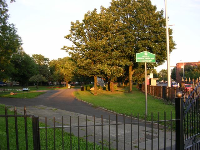
[edit]Ardwick Green Park has recently been refurbished, and though the pond is no more, it still contains an interesting glacial erratic in the form of a boulder.[31] There is also a cenotaph commemorating the Eighth Ardwicks, once a Territorial Army unit of the Manchester Regiment. Ardwick Green Barracks is a fine Victorian castellated structure bearing the old volunteer motto "Defence Not Defiance". It is still in military use today.[32]
The Manchester Apollo, a 1930s Art Deco theatre, is one of Ardwick's most famous landmarks: it was in use as a cinema from 1943 and was renamed the ABC Ardwick in 1962. An independent operator took over in 1977 and staged pop concerts interspersed with the occasional film, until dropping films entirely.[33] The venue now plays host to national and international performing artists.[34]
Extensive demolition of dilapidated Victorian terraces took place around Ardwick during the 1960s. Some residents remained in the area in new council-owned houses and flats, while others were moved to overspill estates[35] such as Hattersley.
Demographics
[edit](According to 2011 census[36])
- White British – 35.5%
- White Irish – 2.4%
- White Other – 5.4%
- Black or Black British – 17.7%
- Asian or Asian British – 27.4%
- Other – 5.5%
- Mixed Race – 6.0%
As of 2021, around 40% of Ardwick's residents were born outside of Europe.[37]
As of 2016, nearly half (48.9%) of all households in Ardwick may be in need of intensive levels of support in order to manage their own health and prevent over-dependence on health services in the future.[38] 61.9% of households in Ardwick may be described as 'deprived' in some way.
Notable people
[edit]- Nellie Beer Lord Mayor of Manchester
- Samuel Birch (1735–1811), military officer, was owner of the Ardwick estate (1780–1795)
- Samuel Hole (1819-1904), Anglican priest, author and horticulturalist, was born in Ardwick
- Stephen Bradbury. Artist and illustrator. Born and brought up as a boy in Ardwick. Heywood House, Bennet Street.
- Edward Brotherton, 1st Baron Brotherton, businessman and philanthropist
- Joe Brown (1930–2020), climber, was born in Ardwick
- Edward Evans, the last of the five Moors Murders victims, was from Ardwick. He was 17 years old when murdered. in October 1965. by Ian Brady in Hattersley.[39]
- Edmund Peck, the illegitimate son of Sir Edmund Buckley. Peck later took the surname Buckley and became Sir Edmund Buckley, 1st Baronet
- Tom Chantrell, designer of many film posters including The Sound of Music and Star Wars[40]
- Elizabeth Gaskell, lived in Gaskell House[41]
- J. Milton Hayes, actor and poet, best known for his 1911 dramatic monologue "The Green Eye of the Little Yellow God"
- Samuel Hibbert-Ware geologist
- Leslie Lever, Baron Lever, lawyer and politician, MP for Ardwick
- Johnny Marr, guitarist, most notably of the Smiths[42]
- Arthur Moreland, political cartoonist and artist[43]
- John Howard Nodal, journalist and philologist
- John Rylands, businessman and philanthropist
- Bill Tarmey (né William Piddington), actor and singer best known for his portrayal as Jack Duckworth in Coronation Street[44]
- Ellen Wilkinson, MP, the Ellen Wilkinson High School, was named after her.
- Harry H. Corbett Actor - moved to Ardwick after mother's death in Burma.[45]
See also
[edit]References
[edit]Notes
- ^ "City of Manchester Ward 2011". Retrieved 4 January 2016.
- ^ Lewis, Samuel (1848). "Appleford – Ardwick". A Topographical Dictionary of England. British History Online. pp. 66–69. Archived from the original on 6 June 2007. Retrieved 4 May 2007.
- ^ a b "Ardwick". Districts & Suburbs of Manchester. Manchester 2002. 2002. Archived from the original on 2 April 2003. Retrieved 4 May 2007.
- ^ a b "The Church of St Thomas, Ardwick". Lancashire OnLine Parish Clerks. Archived from the original on 12 January 2018.
- ^ "The History of Ardwick and St Thomas Centre". stthomascentre.org.uk. Archived from the original on 20 February 2020.
- ^ Wickens 1987, p. 130.
- ^ "St Thomas Centre". stthomascentre.org.uk. Archived from the original on 11 March 2018.
- ^ Historic England. "Former Church of St Thomas (1197828)". National Heritage List for England. Retrieved 20 February 2020.
- ^ Peacock, Doug. "Charles Dickens – writing from life". Cotton Times. Archived from the original on 20 July 2007. Retrieved 5 May 2007.
- ^ "The Ardwick Cemetery". manchesterhistory.net. Archived from the original on 12 October 2017. Retrieved 20 February 2020.
- ^ Historic England. "Anglican Church of St Benedict (1207939)". National Heritage List for England. Retrieved 5 October 2021.
- ^ Fletcher 2013, pp. 43–44.
- ^ O'Rourke, Adrian. "Nicholls Hospital". Retrieved 27 September 2010.
- ^ Fletcher 2013, p. 44.
- ^ Nicholls 2004, p. 58.
- ^ "Top building award goes to... a garage!". Manchester Evening News. 21 February 2006. Archived from the original on 21 February 2020.
- ^ Baker, Richard Anthony (31 May 2014). British Music Hall: An Illustrated History. Pen and Sword. p. 71. ISBN 978-1-78383-118-0.
- ^ "New Manchester Hippodrome Theatre in Manchester, GB - Cinema Treasures". cinematreasures.org. Archived from the original on 17 October 2022. Retrieved 12 October 2021.
- ^ "The Ardwick Empire Theatre, Higher Ardwick and Hyde Road, Ardwick Green, Manchester". www.arthurlloyd.co.uk. Archived from the original on 16 August 2021. Retrieved 12 October 2021.
- ^ "Amna Abdullatif". Manchester City Council. Archived from the original on 17 October 2022. Retrieved 20 February 2020.
- ^ "Abdigafar Muse". Manchester City Council. Retrieved 6 December 2023.
- ^ "Tina Hewitson". Manchester City Council. Archived from the original on 28 September 2020. Retrieved 16 May 2018.
- ^ "The Lord Mayor's Office: Former Lord Mayors of Manchester (1892-Present)". manchester.gov.uk. Manchester City Council. Archived from the original on 1 May 2017. Retrieved 24 March 2017.
- ^ Staff writer (5 October 2012). "Tributes after former Lord Mayor Tom O'Callaghan dies". Manchester Evening News. Trinity Mirror. Archived from the original on 17 October 2022. Retrieved 30 April 2017.
- ^ "Ardwick ward local by-election - Thursday 15 November 2012". manchester.gov.uk. Manchester City Council. 15 November 2012. Archived from the original on 17 October 2022. Retrieved 30 April 2017.
- ^ "History of Ardwick, in Manchester and Lancashire". A Vision of Britain through Time. Retrieved 26 October 2024.
- ^ "Relationships and changes Ardwick CP/Ch/Tn through time". A Vision of Britain through Time. Retrieved 26 October 2024.
- ^ "Population statistics Ardwick CP/Ch/Tn through time". A Vision of Britain through Time. Retrieved 25 October 2024.
- ^ "Trains to Ardwick". Trainline. Archived from the original on 20 February 2020. Retrieved 20 February 2020.
- ^ "Ardwick". chiark.greenend.org.uk. Archived from the original on 19 November 2017. Retrieved 20 February 2020.
- ^ "Geograph:: Glacial erratic at Ardwick Green". geograph.org.uk. Archived from the original on 19 October 2018. Retrieved 9 December 2017.
- ^ "Territorial Army Barracks - Ardwick Green". manchesterhistory.net. Archived from the original on 6 March 2016.
- ^ "O2 Apollo Manchester in Manchester, GB". Cinema Treasures. Archived from the original on 21 January 2020.
- ^ "O2 Apollo Manchester". o2apollomanchester.co.uk. Archived from the original on 6 March 2016.
- ^ Barlow, Nigel (25 June 2015). "Celebrating Ardwick's History". About Manchester. Archived from the original on 7 February 2020.
- ^ "Local area report for Ardwick". Office for National Statistics. Archived from the original on 17 October 2022. Retrieved 7 February 2020.
- ^ "Ardwick - Ward Statistics". Ward Statistics - Ardwick | Manchester City Council. 3 May 2025. Retrieved 3 May 2025.
- ^ Ardwick and Longsight Neighbourhood Mosaic Profile, Manchester City Council, 2016. p1. sourced from manchester.gov.uk
- ^ "Court cleared for Moors murder charges hearing". The Guardian. London: Guardian News and Media. 7 December 1965. Archived from the original on 17 October 2022. Retrieved 29 April 2010.
- ^ Branaghan, Sim (November 2011). "Biography: Tom Chantrell and the World of British Film Posters". Tom Chantrell Posters. Archived from the original on 28 July 2017. Retrieved 28 July 2017.
- ^ "Elizabeth Gaskell's House". 19 July 2023.
- ^ Walters, Sarah (22 March 2013). "Johnny Marr's coming home". Manchester Evening News. Archived from the original on 4 March 2016. Retrieved 24 March 2015.
- ^ Arthur Moreland and his Homage to Dickens, Postcard History, 26 September 2022
- ^ Ottewell, David (1 March 2010). "Coronation Street star Bill Tarney calls for NHS support". M.E.N. Media.
- ^ Corbett, S. (2012). Harry H. Corbett – The Front Legs of the Cow. The History Press, Stroud, Glos. ISBN 978-0-7524-7682-7
Bibliography
- Fletcher, Tony (2013). A Light That Never Goes Out - The Enduring Saga of the Smiths. Random House. ISBN 978-0-09-953792-2.
- Nicholls, Robert (2004). Curiosities of Greater Manchester. Stroud: Sutton. ISBN 978-0-7509-3661-3.
- Wickens, David C (1987). The Instruments of Samuel Green. Palgrave Macmillan. ISBN 978-1-349-09061-7. Archived from the original on 17 October 2022. Retrieved 21 September 2020.
Further reading
[edit]- Frangopulo, N. J. (1962) Rich Inheritance. Manchester: Education Committee; pp. 270–271 contain: "The history of a district, e.g. Ardwick", a list of documents held at Manchester Central Library
- Makepeace, Chris (1995). Looking Back at Hulme, Moss Side, Chorlton on Medlock & Ardwick. Timperley: Willow Publishing. ISBN 978-0-946361-34-2.
External links
[edit]| National | |
|---|---|
| Geographic | |
Ardwick
View on GrokipediaHistory
Pre-Industrial Origins
Ardwick emerged as a rural township within the ancient parish of Manchester, first recorded in 1282 as Atheriswyke, situated along the road from Manchester to Stockport amid open countryside.[10][2] The area featured sparse settlement, with principal landownership held by the Birch family, who possessed Ardwick Manor; Samuel Birch, father of Parliamentarian colonel John Birch, exemplified their prominence in the locality during the 17th century.[11] By the mid-18th century, Ardwick retained its agrarian character, supporting a modest population of 242 residents across 47 houses in 1773.[12] Key estates included Ardwick Hall, a substantial country house set in wooded grounds near Ardwick Green, as shown on contemporary maps depicting the surrounding leafy terrain.[13] To address the distance from Manchester's parish church, Samuel Birch donated land in 1740 for St Thomas Church, consecrated as a chapelry in 1741 to serve Ardwick and nearby Chorlton Row.[12] Population growth accelerated in the early 19th century due to Ardwick's adjacency to Manchester, reaching over 5,000 inhabitants by 1831 while still predominantly rural in form.[12] This expansion foreshadowed suburbanization but preceded widespread industrialization, with the township incorporating into Manchester borough only in 1838.[12][2]Industrial Expansion and Peak
Ardwick's incorporation into the Borough of Manchester in 1838 marked the onset of its integration into the city's expanding industrial framework, facilitating coordinated urban development amid the Industrial Revolution's demands for labor and infrastructure.[12] This administrative change aligned with Manchester's textile and manufacturing boom, as canal and later railway links—such as the Manchester and Sheffield Railway station opened nearby—enabled efficient transport of goods and workers, spurring Ardwick's transformation from rural outskirts to a densely populated suburb.[2] The area's population surged to approximately 15,793 by the 1851 census, driven by employment opportunities in proximate factories, and exceeded 40,000 by 1901, underscoring the causal pull of industrial expansion on migration and settlement patterns.[12][14] Factories proliferated, encompassing textile mills, engineering firms, brickworks, and chemical plants, which not only generated jobs but also necessitated rapid construction of terraced housing to accommodate influxes of operatives from rural areas and Ireland.[6][12] Infrastructure developments reflected this growth, including the 1831 enlargement of St Thomas Church—Manchester's third-oldest, originally consecrated in 1741—to serve the expanding community, alongside Ardwick Green's role as an early public recreational space amid urban densification.[15][16] By the early 20th century, cultural institutions emerged to cater to the prosperous working-class demographic, exemplified by the Ardwick Empire Theatre's opening in 1904 as a variety venue with capacity for around 3,000 patrons.[17] These elements collectively positioned Ardwick at the peak of its industrial vitality, intertwined with Manchester's dominance in cotton processing and mechanical engineering.[18]Post-War Decline and Deindustrialization
Following the Second World War, Ardwick experienced significant industrial contraction as Manchester's manufacturing base eroded, with the city losing approximately 207,000 manufacturing jobs between 1972 and 1984 amid broader national deindustrialization driven by global competition, technological shifts, and policy changes favoring service sectors.[19] In east Manchester, including Ardwick, nearly half of jobs vanished between 1975 and 1985, particularly in textiles and engineering, leaving few large employers and exacerbating structural unemployment that reached 20% citywide by the mid-1980s, far above national averages.[6][20] This shift severed community ties historically anchored in factory work, fostering dependency on state benefits and undermining local economic resilience without effective retraining or diversification initiatives. Local council housing policies compounded the downturn through ambitious but flawed high-rise developments, exemplified by Fort Ardwick (Coverdale Crescent), constructed in the early 1970s as part of Manchester's post-war slum clearance efforts to rehouse displaced workers.[21] Intended to provide modern, dense accommodation, the estate's brutalist design and isolation from street-level amenities instead promoted social fragmentation, vandalism, and maintenance failures, prompting resident complaints of ugliness and insecurity by the late 1970s.[22] Demolished in 1992 after less than two decades, it symbolized the unintended consequences of top-down urban planning that prioritized quantity over community cohesion, displacing families without addressing underlying job losses.[21] By the 1970s and 1980s, these factors manifested in escalating deprivation, with Ardwick registering high rates of long-term unemployment, poor health outcomes, and low educational attainment linked directly to industrial job evaporation rather than isolated policy errors.[6] National data on regional inequality highlight how such areas, reliant on declining sectors, saw persistent poverty traps, culminating in Ardwick's ranking among England's top 1% most deprived wards by 2011, reflecting cumulative effects of unmitigated deindustrialization and housing missteps that eroded social capital.[6] Local decisions, including over-reliance on welfare housing without industrial retention strategies, intensified these trends, prioritizing short-term relocation over sustainable employment transitions.[23]Geography
Location and Boundaries
Ardwick constitutes an inner-city district in eastern Manchester, Greater Manchester, England, positioned approximately 1.5 kilometres southeast of the city centre.[24] The area encompasses flat urban terrain typical of the surrounding Cheshire Plain, with elevations generally below 60 metres above sea level and featuring limited topographical variation aside from man-made structures and green spaces like Ardwick Green.[25] Its boundaries adjoin several neighbouring districts, including Longsight to the south, Gorton (historically West Gorton) to the east, Rusholme to the southwest, and Chorlton upon Medlock to the northwest, with the River Medlock serving as a traditional northern demarcation from central Manchester areas.[5] Key thoroughfares such as Hyde Road mark the southern edge, while the district lies proximate to the University of Manchester's facilities along Oxford Road to the west.[5] Ardwick primarily falls within postcode districts M12 and M13, corresponding to the modern Ardwick electoral ward of Manchester City Council, which covers an approximate area of 1.3 square kilometres based on population density data.[26][27]Key Landmarks and Features
Ardwick Green functions as the district's primary parkland, initially developed as a private recreational area for nearby residents before Manchester Corporation acquired it in 1867 for public use.[28] The site encompasses approximately 6 acres of maintained lawns, flowerbeds, shrubberies, and pedestrian paths, with a children's playground incorporated during a 1948 redesign.[29] Encircled by Grade II listed Georgian-era residences, the green preserves elements of Ardwick's early suburban character amid later urban encroachment.[30] The St Thomas Centre, originating as St. Thomas's Church, stands as a Grade II listed structure erected in 1741 in Italianate style, with expansions completed in 1777 and 1831 to accommodate growing congregations.[15] Converted from ecclesiastical to secular use, the building now operates as a conference and meeting venue, retaining its architectural prominence on Ardwick Green North.[31] Several notable edifices have been lost to demolition, underscoring architectural attrition in the area. Ardwick Hall, an early manor house tied to the district's pre-industrial estate, was razed circa 1929 for industrial redevelopment.[13] Similarly, the Ardwick Empire Theatre, a 1904 music hall later rebranded as the New Manchester Hippodrome, hosted variety performances until its closure and demolition in 1964.[32] Enduring structures include Fenton House, a Grade II listed Regency-style townhouse dating to the late 18th century with 19th-century modifications, located on Higher Ardwick.[33] The former Nicholls Hospital, a Gothic Revival complex designed by Thomas Worthington and constructed from 1878 to 1880 as a charitable institution funded by Benjamin Nicholls, persists as an educational facility on Hyde Road.[34][35] These sites, documented in preservation listings, highlight remnants of Victorian philanthropy and residential architecture amid industrial overlays.Governance and Administration
Incorporation and Civic Evolution
Ardwick originated as one of approximately 30 townships comprising the ancient parish of Manchester in Lancashire.[12] Prior to formal incorporation, it functioned under township governance, with local officials handling basic functions such as poor relief and road maintenance through vestry meetings.[36] On 23 October 1838, Ardwick was incorporated into the Borough of Manchester via royal charter under the Municipal Corporations Act 1835, alongside townships including Cheetham, Hulme, and Chorlton-on-Medlock.[37] This administrative consolidation transferred authority to a mayor, aldermen, and councillors, centralizing control over services like sanitation, policing, and infrastructure, which enhanced resource allocation compared to fragmented township management.[38] Population data indicate subsequent growth from over 5,000 residents in 1831 to 15,000 by 1851, correlating with borough-led improvements in water supply and street lighting that supported urban expansion.[12] Ecclesiastical evolution paralleled civic changes, with Ardwick designated a chapelry by the mid-19th century; St. Thomas's Church was consecrated in 1839 as part of the parish of Manchester, and by 1870 it encompassed three chapelries and a subdistrict for registration purposes.[5][39] The borough's governance framework extended to funding such developments, streamlining administrative oversight amid rapid industrialization. In the 20th century, as part of the City of Manchester—elevated from borough status in 1853—Ardwick's administration fell under expanded municipal powers, enabling large-scale interventions like post-war slum clearances authorized by the Housing Act 1936 and subsequent legislation.[38] Manchester City Council directed clearances of overcrowded terraces in Ardwick during the 1950s–1970s, displacing thousands and funding rehousing in council estates, including Fort Ardwick completed in 1972 with 500 units on Coverdale Crescent.[40] These efforts demonstrated centralized efficiency in addressing substandard housing—evidenced by reduced overcrowding rates from 20% in 1951 to under 5% by 1971 citywide—but also highlighted challenges in local responsiveness, as top-down planning contributed to social disruptions observed in subsequent estate deteriorations.[40]Current Administrative Status
Ardwick forms an electoral ward of Manchester City Council, one of 32 wards in the authority, each represented by three councillors who contribute to municipal governance on matters including community services, housing management, and local planning enforcement.[41] [7] Ward-level decisions are integrated into broader council policies, with councillors addressing resident concerns through mechanisms like ward forums and budget allocations for initiatives such as street maintenance and neighborhood policing partnerships.[42] The ward operates within the framework of the Greater Manchester Combined Authority (GMCA), a devolved body comprising Manchester City Council and nine other local authorities, responsible for regional oversight of transport infrastructure, skills training, and economic regeneration programs that impact Ardwick's connectivity and service delivery. GMCA's influence extends to policy coordination on cross-boundary issues, including fire and rescue services and spatial planning, enabling pooled funding for projects like improved public realm enhancements in inner-city wards.[43] Local funding for Ardwick's administrative functions relies on a combination of council tax precepts, central government revenue support grants, and devolved settlements from GMCA, which as of April 2025 include integrated funding streams for housing delivery and adult social care, totaling allocations that support targeted interventions amid fiscal constraints from national austerity measures.[44] Policing remains under Greater Manchester Police, with council input via community safety partnerships funded jointly at the ward and regional levels to address priorities like antisocial behavior and vulnerability safeguarding.Demographics
Population Dynamics
Ardwick's population surged during the 19th-century industrial boom, fueled by job creation in textiles, engineering, and rail infrastructure, which drew migrant workers to the area and transformed it from a rural township into a densely packed urban district. By the early 20th century, this expansion had pushed resident numbers to over 40,000, reflecting peak manufacturing employment before economic shifts began eroding the local base. Post-World War II deindustrialization, marked by factory closures and slum clearances under urban renewal policies, triggered a sharp contraction, as families relocated to suburbs or new housing estates amid job losses and infrastructure decay.[45] Census data illustrate the long-term trajectory: from a low of 13,884 residents in 2001—reflecting decades of out-migration tied to economic stagnation—the ward saw steady rebound to 19,409 by 2011 and 21,042 by 2021, coinciding with Manchester's broader urban regeneration and influx of students to nearby universities. This recent stabilization stems from causal factors like affordable housing relative to the city center, improved transport links, and demand for communal accommodations, with 17.4% of residents (approximately 3,650 individuals) living in such establishments in 2021, compared to 86.2% (17,392) in households.[7] High deprivation affecting 61.9% of households has tempered net growth by constraining family formation and retention, yet proximity to employment hubs has sustained young adult inflows.[7]| Census Year | Population |
|---|---|
| 2001 | 13,884 |
| 2011 | 19,409 |
| 2021 | 21,042 |