
Community hub
Recent from talks
Contribute something
Nothing was collected or created yet.
Beitbridge
View on Wikipedia
Beitbridge is a border town in the province of Matabeleland South, Zimbabwe. The name also refers to the border post and bridge spanning the Limpopo River, which forms the political border between South Africa and Zimbabwe. The border on the South African side of the river is also named Beitbridge.
Key Information


Background
[edit]The town lies just north of the Limpopo River about 1 km from the Alfred Beit Road Bridge which spans the Limpopo between South Africa and Zimbabwe. The main roads are the A6 highway to Bulawayo and the Victoria Falls, being 321 kilometres (199 mi) and 758 kilometres (471 mi) away respectively and the A4 to Masvingo and Harare. According to the 2012 population census, the town had a population of 41,767 dominated by the Venda and Ndebele people. There is a sizable percentage of Shona people from other provinces. This is a busy border post with traders from all over Zimbabwe. The Beitbridge border post is the busiest road border post in Southern Africa, and is best avoided during busy border-crossing seasons.
Climate
[edit]| Climate data for Beitbridge (1961–1990) | |||||||||||||
|---|---|---|---|---|---|---|---|---|---|---|---|---|---|
| Month | Jan | Feb | Mar | Apr | May | Jun | Jul | Aug | Sep | Oct | Nov | Dec | Year |
| Record high °C (°F) | 43.3 (109.9) |
42.3 (108.1) |
43.3 (109.9) |
39.4 (102.9) |
36.7 (98.1) |
36.6 (97.9) |
33.9 (93.0) |
40.2 (104.4) |
40.0 (104.0) |
43.3 (109.9) |
44.4 (111.9) |
44.7 (112.5) |
44.7 (112.5) |
| Mean daily maximum °C (°F) | 33.5 (92.3) |
32.8 (91.0) |
32.0 (89.6) |
30.4 (86.7) |
28.2 (82.8) |
25.4 (77.7) |
25.4 (77.7) |
27.6 (81.7) |
30.2 (86.4) |
31.8 (89.2) |
31.8 (89.2) |
33.1 (91.6) |
30.2 (86.4) |
| Mean daily minimum °C (°F) | 21.9 (71.4) |
21.5 (70.7) |
20.1 (68.2) |
17.0 (62.6) |
11.9 (53.4) |
8.2 (46.8) |
7.9 (46.2) |
10.7 (51.3) |
15.2 (59.4) |
18.6 (65.5) |
20.3 (68.5) |
21.2 (70.2) |
16.2 (61.2) |
| Record low °C (°F) | 12.8 (55.0) |
14.4 (57.9) |
11.7 (53.1) |
3.9 (39.0) |
2.8 (37.0) |
−1.1 (30.0) |
−0.6 (30.9) |
0.0 (32.0) |
4.4 (39.9) |
8.9 (48.0) |
11.1 (52.0) |
13.3 (55.9) |
−1.1 (30.0) |
| Average rainfall mm (inches) | 56.8 (2.24) |
54.8 (2.16) |
34.1 (1.34) |
25.6 (1.01) |
10.0 (0.39) |
3.1 (0.12) |
0.4 (0.02) |
1.5 (0.06) |
14.9 (0.59) |
28.4 (1.12) |
48.7 (1.92) |
53.7 (2.11) |
332.0 (13.07) |
| Average rainy days | 5 | 4 | 3 | 2 | 1 | 1 | 0 | 0 | 1 | 2 | 5 | 5 | 29 |
| Average relative humidity (%) | 62 | 64 | 60 | 58 | 52 | 56 | 51 | 46 | 46 | 48 | 53 | 57 | 54 |
| Mean monthly sunshine hours | 244.9 | 217.5 | 241.8 | 240.0 | 275.9 | 252.0 | 263.5 | 272.8 | 252.0 | 248.0 | 225.0 | 226.3 | 2,959.7 |
| Mean daily sunshine hours | 7.9 | 7.7 | 7.8 | 8.0 | 8.9 | 8.4 | 8.5 | 8.8 | 8.4 | 8.0 | 7.5 | 7.3 | 8.1 |
| Source 1: World Meteorological Organization[2] | |||||||||||||
| Source 2: Deutscher Wetterdienst (extremes, humidity, and sun)[3][4] | |||||||||||||
The Town
[edit]Beitbridge has an estimated 2,570 houses in formal settlements (primarily for government officials and mid-level private sector staff) and 3,000 in informal settlements. Formal-settlement dwellings are mainly two- to three-room brick houses, while those in the informal settlements are among the worst mud houses in Zimbabwe. The mud houses have since been demolished. Average house occupancy in the low-income and informal settlements varies considerably, as many people do not bring their families to Beitbridge, but includes at least four people. Recreational facilities are limited in low-income areas, consisting largely of bars and soccer pitches.
Labour
[edit]The major sources of local employment—freight, retail, construction, customs and the police—employ about 1,200 people. Informal sector activities—primarily vending and sex work—are as large as those in the formal sector, employing about 1,400. Outside of Beitbridge, farming is a major employer. A diamond mine recently closed, increasing unemployment and poverty. Most women rely on vending, sex work and cross-border trading for income. Truckers are present in the area with work coming from the border area of South Africa.
The Bridge
[edit]The Alfred Beit Road Bridge is named after Alfred Beit, founder of the De Beers diamond mining company and business associate of Cecil Rhodes. He was also a director of a number of companies, among them the British South Africa Company and Rhodesia Railways. The original bridge was constructed in 1929 at a cost of $600,000 and financed jointly between the Beit Railways Trust and the South African Railways.[5] The new bridge was completed in 1995, and was officially opened on 24 November. It was built by the Zimbabwean Government, which now benefits from the tolls levied on crossings. The new bridge can accommodate much heavier traffic than the old one could, which is now for rail traffic only.[citation needed]
Development
[edit]
On the South African side of the border the N1 Highway connects this border post to the main economic centres of Pretoria (463 km) and Johannesburg (521 km). The closest town is Musina (16 km). On the Zimbabwean side of the border post the road splits in two, with the A6 running to Bulawayo and the R1 to Masvingo. A railway also passes through this border post, side by side with the road, and splits into a line to Bulawayo and a line to Gweru via Rutenga.[citation needed]
Three railway lines meet at Beitbridge: the South African Spoornet line to Polokwane, the National Railways of Zimbabwe line to Gweru via Rutenga and the Beitbridge Bulawayo Railway.[citation needed]
Education
[edit]There are four primary schools in the town namely Beitbridge Mission, Beitbridge Government, Dulivhadzimo Primary and St Mary's Primary School. There is a private school in the town named under Oakleigh House Trust School. Two secondary schools, Vhembe High School and St Joseph's Secondary School, cater for the post primary education in the town. There is no tertiary education facility in the town and high school graduates travel to district outside Beitbridge for tertiary education.
Venue
[edit]Dulivhadzimu Stadium, a small multi-purpose arena in the town was chosen by the ZANU-PF led 21st February Movement to host the annual national celebration of Robert Mugabe's date of birth on Saturday, 23 February 2008. On 21 February, two days before, Mugabe had turned 84.[6] It was reported that workers repaired the potholes on the main roads in the city to make sure Mugabe's motorcade moved swiftly with a measure of comfort[citation needed].
Transportation
[edit]The Beitbridge Bulawayo Railway serves the town with train services to Bulawayo.
See also
[edit]References
[edit]- ^ Citypopulation.de Population of cities & urban localities in Zimbabwe
- ^ "World Weather Information Service – Beitbridge". World Meteorological Organization. Retrieved 12 May 2016.
- ^ "Klimatafel von Beitbridge / Simbabwe" (PDF). Baseline climate means (1961–1990) from stations all over the world (in German). Deutscher Wetterdienst. Retrieved 12 May 2016.
- ^ "67991: Beitbridge (Zimbabwe)". ogimet.com. OGIMET. 13 December 2024. Retrieved 13 December 2024.
- ^ New Alfred Beit Bridge is opened Montreal Gazette, 2 September 1929
- ^ Beitbridge readies of Mugabe [1] Archived 28 February 2008 at the Wayback Machine (accessed 20 February 2008)
External links
[edit]- Covid-19 poser as trucks overwhelm Beitbridge Border Post As of 12 June 2020.
| International | |
|---|---|
| National | |
| Other | |
Capital: Beitbridge | |
| Wards | |
| Rivers | |
| Dams/reservoirs | |
| Landforms | |
| Settlements | |
| Transport | |
| Protected areas | |
| Education |
|
| Culture and sport | |
| Notable people | |
| Constituencies | |
Beitbridge
View on GrokipediaBeitbridge is a border town in Zimbabwe's Matabeleland South Province, situated at the southernmost point of the country along the Limpopo River, directly opposite Musina in South Africa. It functions as the administrative center of Beitbridge District and is defined by the Beitbridge Border Post, the primary official land crossing between Zimbabwe and South Africa, which handles over 15,000 daily movements of people and vehicles, making it the busiest such post in sub-Saharan Africa.[1][2] Established in 1929 and named after British philanthropist Alfred Beit, whose funded bridge spans the Limpopo, the town originated as a railway terminus connecting to South Africa until the line's extension in 1974.[1] Its population reached 58,574 in the 2022 census, reflecting rapid growth driven by border-related opportunities, with an economy anchored in freight transport, cross-border commerce, and services supporting regional trade flows exceeding thousands of trucks weekly.[3][4] Beitbridge's strategic role has spurred infrastructure upgrades, including border post modernization that alleviated chronic congestion, alongside developments like a special economic zone targeting mining, processing, and energy investments to diversify beyond transit dependencies.[5][6] The locality contends with persistent informal crossings—over 20 undocumented points along the border—and migration pressures, yet sustains essential connectivity for southern African economic integration.[2]
Geography
Location and Borders
Beitbridge is situated in Matabeleland South Province, Zimbabwe, serving as the administrative center of Beitbridge District. The town lies at geographical coordinates of approximately 22°13′S 30°00′E.[7][8] It is positioned on the northern bank of the Limpopo River, approximately 18 kilometers north of Musina in South Africa's Limpopo Province.[9] The town's primary border is the international boundary with South Africa, demarcated by the Limpopo River, which forms a natural divide. This border facilitates significant cross-border trade and movement, with Beitbridge functioning as Zimbabwe's main gateway to South Africa.[10] The district represents the southernmost extent of Zimbabwean territory, with the river serving as the southern limit.[11] Internally, Beitbridge District adjoins other districts within Matabeleland South Province to the north and west, though specific boundaries are defined by provincial administrative lines.
Topography and Climate
Beitbridge lies in Zimbabwe's Lowveld region, part of the broader Limpopo River basin, at an elevation of approximately 457 meters (1,499 feet) above sea level. The local topography features flat to gently undulating plains dominated by Kalahari-type sandy soils and savanna grasslands, with the Limpopo River forming the southern boundary and influencing seasonal flooding in adjacent floodplains. Relief is minimal, with elevations in the surrounding district averaging 480 to 640 meters, supporting sparse thornveld vegetation and extensive cattle grazing lands rather than intensive agriculture due to the shallow soils and low relief.[12][13][14] The area has a hot semi-arid climate classified as BSh under the Köppen system, marked by high temperatures year-round and erratic precipitation. Average annual rainfall totals 400 to 600 millimeters, with over 80% falling during the wet season from November to March, peaking at around 76 millimeters in January; the dry season from April to October receives negligible amounts, often less than 10 millimeters monthly. Mean daily temperatures range from 24°C to 27°C annually, with summer highs frequently exceeding 35°C (October to March) and winter minimums dipping to 5°C or lower (June to August), accompanied by occasional frost in low-lying areas.[15][16][17]History
Colonial Origins and Bridge Construction
The region encompassing modern Beitbridge formed part of Southern Rhodesia, a British colony that achieved self-governing status in 1923 after decades of administration by the British South Africa Company, which had occupied the territory from Matabeleland northward since the 1890s. Before permanent infrastructure, the Limpopo River served as a natural boundary, with informal crossings such as Liebig's Drift enabling limited trade, cattle drives, and migration between Southern Rhodesia and the neighboring Union of South Africa, though subject to seasonal flooding and rudimentary ferry operations.[18] To enhance connectivity for rail and road transport vital to colonial economic interests, including mineral exports and agricultural trade, the site for a bridge was selected in 1926 near Liebig's Drift. Construction commenced in 1928 under the design of engineer Ralph Freeman of Douglas Fox and Partners, with Dorman Long as the contractor and James Mackenzie providing supervision; the project yielded a steel deck bridge spanning 462 meters and weighing 1,876 tons.[18][19] Financed at a cost of $600,000 primarily by the trustees of the Beit Railway Trust—established via the 1906 will of Alfred Beit, the German-born financier and associate of Cecil Rhodes who amassed wealth through diamond and gold ventures in southern Africa—the bridge served as a memorial to Beit and supported broader colonial infrastructure goals. Additional funding came from the South African Railways, reflecting joint colonial interests in linking the Union's network to Southern Rhodesia's lines.[18][19][20] The Alfred Beit Road Bridge opened on 31 August 1929, initially operated by the South African Railways and Harbours Administration per an inter-governmental agreement, before joint custody by the two administrations; it immediately boosted freight movement, with rail lines extended to the border to integrate Southern Rhodesia's economy more firmly with South African ports. This development spurred the formal establishment of Beitbridge as a border town in 1929, laying the foundational infrastructure for subsequent growth amid Rhodesia's colonial expansion.[18][19]Rhodesian Era and Early Independence
During the period following Rhodesia's Unilateral Declaration of Independence on November 11, 1965, Beitbridge emerged as a pivotal border crossing, sustaining the economy through unregulated trade with South Africa, which refrained from fully enforcing international sanctions. The post facilitated the import of critical goods, including oil, via road convoys that became a primary artery for sanctions evasion, underscoring the Limpopo River bridge's strategic value in circumventing global isolation.[21][22] As the Rhodesian Bush War intensified from the mid-1970s, the Beitbridge-Beatrice road was recognized as vital infrastructure, prompting the government to mandate armed escorts for all vehicular traffic starting around 1977 to counter guerrilla ambushes and sabotage. Incidents included the explosion of a landmine or device that derailed a Rhodesia Railways train on the Beitbridge-Rutenga line approximately 20 kilometers from the border on May 30, 1979, highlighting vulnerabilities in southern supply routes despite lower insurgent activity compared to northern frontiers. The border post itself saw militarization by units such as the Guard Force, with operations focused on preventing infiltrations from Botswana and securing the area amid broader counterinsurgency efforts.[23][24][25] Zimbabwe's independence on April 18, 1980, transitioned Beitbridge into the new nation's chief southern gateway, with sanctions lifted enabling expanded trade volumes and initial economic optimism in the 1980s. However, political instability persisted in Matabeleland South, where ethnic and partisan rivalries between ZANU-PF and ZAPU forces led to sporadic violence; notably, on November 10, 1984, twenty ZAPU supporters were killed in clashes at Beitbridge amid escalating tensions that foreshadowed broader disturbances. The post's operations adapted to integrate former Rhodesian security personnel and ex-guerrillas, though cross-border dynamics with South Africa remained tense due to regional conflicts.[26][27]Post-2000 Economic and Political Shifts
Zimbabwe's fast-track land reform program, initiated in 2000, precipitated a national economic downturn that severely impacted Beitbridge, transforming its role from a conduit for formal agricultural exports to a hub for informal survival economies. The reforms, which involved violent seizures of commercial farms, led to a 60% drop in tobacco production by 2008 and broader agricultural collapse, exacerbating foreign exchange shortages and fueling hyperinflation that reached 89.7 sextillion percent in November 2008.[28][29] In Beitbridge, this manifested as widespread border transgressions, including smuggling of commodities like fuel and goods, as informal cross-border traders exploited porous controls to circumvent official exchange rates and sanctions-induced shortages.[30][31][32] The hyperinflation era prompted adaptive political responses at the border, including protests in the early 2000s against government bans on fuel imports, which aimed to ration scarce resources but instead spurred black market activities and cross-border arbitrage.[28][33] Under ZANU-PF dominance, local governance in Beitbridge aligned with national policies of state-centric control, yet the economic distress amplified migration and remittances, with cross-border flows supporting household incomes in border communities.[34] By 2009, the government's adoption of a multi-currency system, anchored to the U.S. dollar, halted hyperinflation and revived trade volumes, positioning Beitbridge as a critical artery for Zimbabwe's re-engagement with South African markets.[35][29] Post-2009 stabilization efforts included infrastructure upgrades at the Beitbridge border post, such as the introduction of electronic systems and bilateral agreements with South Africa for a one-stop border post, which reduced commercial truck crossing times from 35-65 hours to 14 hours by 2018.[36] These changes, handling over 13,000 daily travelers, 400 buses, and 750 trucks, aimed to formalize trade and curb smuggling, though informal economies persisted amid ongoing policy inconsistencies following Robert Mugabe's 2017 ouster.[37] Politically, the shift to Emmerson Mnangagwa's administration emphasized economic re-engagement, but entrenched corruption and elite capture limited gains, with Beitbridge remaining a flashpoint for smuggling networks tied to survival amid stagnant formal growth.[38][39]Border Infrastructure
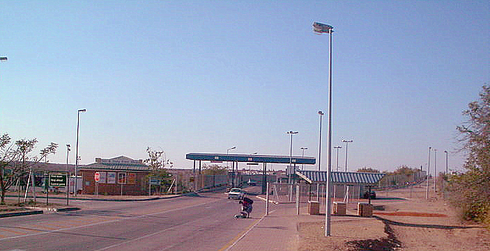
The Beit Bridge
The Alfred Beit Road Bridge, commonly known as the Beit Bridge, is a vital international crossing over the Limpopo River, connecting Beitbridge in Zimbabwe to Musina in South Africa.[40] Construction of the original bridge began in 1928 near Liebig's Drift and was completed in 1929 to establish road links between South Africa and Southern Rhodesia.[18] [41] Named after the financier Alfred Beit, who contributed to its funding through the Beit Railways Trust, the structure initially served vehicular traffic on what became a key trade route.[41] By the mid-1990s, escalating commercial volumes necessitated replacement for road use; a new parallel bridge, also designated the Alfred Beit Road Bridge, opened in 1995.[40] This modern iteration extends 462 meters in total length, supported by reinforced concrete piers, and features a wider and higher deck than the original to accommodate heavier loads, enhance traffic efficiency, and reduce vulnerability to seasonal flooding from the Limpopo River.[40] [42] The predecessor bridge was repurposed thereafter primarily for rail traffic, preserving its historical role while diverting road vehicles to the upgraded span.[43] As the primary artery for cross-border commerce in the region, the Beit Bridge facilitates the movement of goods and people along the N1 highway corridor, underpinning economic ties between Zimbabwe, South Africa, and broader Southern African markets despite periodic maintenance challenges from high usage and environmental factors.[42]Border Post Design and Operations
The Beitbridge Border Post on the Zimbabwean side features a modernized layout designed to accommodate high-volume cross-border traffic, including dedicated terminals for passengers, commercial vehicles, and cargo. The infrastructure incorporates separate lanes for different vehicle types, advanced scanning equipment for inspections, and expanded processing areas to streamline customs and immigration procedures. This design emerged from a Build-Operate-Transfer concession awarded to Zimborders Mauritius in 2018, which funded upgrades costing approximately USD 44 million through investments like the Private Infrastructure Development Group's Emerging Africa Infrastructure Fund.[44] [36] [45] Operational capacity at the post supports roughly 500 trucks and 20,000 individuals daily, though historical congestion has frequently exceeded this, leading to delays of 35-65 hours for commercial traffic prior to upgrades. Post-modernization, average crossing times dropped to 14 hours for trucks and 3 hours for non-commercial travelers, facilitated by digitized systems for data sharing, risk profiling, and automated clearance processes managed by agencies such as the Zimbabwe Revenue Authority and immigration services. These enhancements include real-time visibility into bottlenecks, enabling faster decision-making and reduced smuggling risks through better surveillance and infrastructure.[46] [36] [47] Coordination with the South African side remains partially separate, but joint initiatives toward a full One-Stop Border Post (OSBP) are advancing, with construction underway as of September 2025 to integrate operations and further cut redundancies. Ministers from both countries toured the upgraded facilities in September 2025, highlighting boosted capacity and efficiency standards for regional trade, though construction phases have temporarily impacted throughput. Ongoing assessments by the Southern African Development Community evaluate operating hours, procedural alignment, and technological interoperability to sustain improvements.[48] [49] [50]Economy
Trade Volumes and Regional Role
Beitbridge functions as the primary land border post for trade between Zimbabwe and South Africa, handling the bulk of bilateral freight movements and serving as a critical node in the North-South Corridor that links southern Africa to central and eastern regions.[51][52] As Zimbabwe's largest trading partner, South Africa accounts for a substantial share of Zimbabwe's imports, including refined petroleum, fertilizers, and machinery, with much of this volume transiting Beitbridge due to its position on the main highway route.[53][54] The post also supports informal cross-border trade, estimated to constitute 30-72% of regional formal trade value in southern Africa, involving goods like foodstuffs and consumer items that sustain local economies on both sides.[55] Recent enhancements, including integrated customs systems and one-stop border post initiatives, have boosted operational efficiency and trade flows, with Southern African Development Community (SADC) assessments in July 2025 noting reduced processing times and recommending accelerated implementation of shared border management.[51][56] Daily heavy goods vehicle traffic reached 1,580 trucks in August 2025, reflecting sustained high volumes despite occasional queues averaging 5.8 hours.[57] Imports of pre-owned vehicles through the post surged over 40% in the preceding eight months as of early 2025, underscoring its role in responding to regional demand fluctuations.[58] In the broader SADC context, Beitbridge underpins regional integration by enabling access for landlocked Zimbabwe to South African ports and onward connectivity to markets in Botswana, Malawi, and beyond, with ongoing bilateral efforts focusing on digital clearance and infrastructure upgrades to handle projected growth in mineral exports like gold and ferrochrome.[52][59] These dynamics position the post as a linchpin for economic interdependence, though challenges like informal trade evasion and capacity constraints persist.[60]Labour Market Dynamics
The labour market in Beitbridge is predominantly shaped by its role as a key border crossing point, with major employment sources including the freight and logistics industry, retail trade, construction activities, immigration and customs services, government administration, and operations of non-governmental organisations.[4] Informal cross-border trading constitutes a significant portion of economic activity, often involving small-scale operators, particularly women, who transport goods such as foodstuffs and consumer items between Zimbabwe and South Africa, though this sector faces challenges from regulatory hurdles and economic volatility.[61] Workforce participation is influenced by high population mobility, with substantial outflows of migrants from Beitbridge to South Africa—accounting for 46% of recorded migrant departures in July 2024—driven by better wage opportunities in mining, agriculture, and services across the border, leading to reliance on remittances for local household incomes.[62] Recent industrial developments have introduced formal job opportunities, as seen in the Palm River Energy Park, a steelworks and energy project that created 110 positions by September 2025, with a focus on local hiring from Beitbridge communities to support manufacturing and energy production.[63] Despite national unemployment estimates hovering around 8.6% in 2024—largely understated due to the dominance of informal self-employment—local dynamics reflect structural underemployment, with youth expressing frustration over limited formal prospects, as highlighted in community engagements with representatives as early as 2020.[64][65] Border infrastructure upgrades and trade facilitation efforts by regional bodies like SADC have sporadically boosted short-term construction and logistics jobs, yet persistent skills mismatches and economic informality constrain long-term labour absorption.[50]Urban and Social Development
Municipal Governance and Infrastructure
The Municipality of Beitbridge serves as the local authority for the town, having been established as a town council on 1 July 2007 under Zimbabwean urban governance legislation.[66] The municipal area is divided into six wards, each represented by an elected councillor who contributes to decision-making on service delivery and development priorities.[66] Its core mandate encompasses the provision of essential services to residents, including town planning, land development, water supply, sanitation, waste management, refuse collection, fire and rescue operations, and recreational facilities.[67] Infrastructure in Beitbridge includes a reliable potable water supply system, described by municipal authorities as constant and of high quality to meet local demands.[4] Electricity provision is sufficient for residential and commercial needs, supporting ongoing developments without reported shortages specific to the town.[4] Road maintenance within the municipal jurisdiction has benefited from national programs, such as the Zimbabwe National Road Administration's (ZINARA) Emergency Roads Rehabilitation Scheme, which addressed previously impassable routes in 2022.[68] Sanitation and stormwater management remain active priorities, with the municipality initiating drain cleaning operations across the town in October 2025 to mitigate flooding risks ahead of the rainy season.[69] Waste management services handle refuse collection systematically, aligning with broader local economic development goals that emphasize gender-inclusive practices in operations.[70] These efforts reflect incremental improvements, though broader Zimbabwean infrastructure constraints, such as intermittent national power grid issues, occasionally affect reliability despite local adequacy claims.[71]Education and Healthcare Facilities
Beitbridge's education infrastructure consists primarily of public primary and secondary schools supplemented by a limited number of private institutions, amid chronic shortages driven by rapid population growth and border-related migration. As of 2020, the district faced a deficit of 25 primary schools and 15 secondary schools to serve an estimated 250,000 learners, reflecting underinvestment relative to demographic pressures. Private schools have partially addressed gaps; Oakleigh House Trust School, founded in 2007, expanded in September 2025 to include 36 classrooms, a computer room, science laboratory, and STEM facilities for kindergarten through emerging college levels. Other notable facilities include Wellton Primary School, which emphasizes academic and technological skills development, and Tshabili Secondary School, enrolling 251 students with seven resident teachers as of 2025. Secondary options encompass Tromehus Training Centre, a registered institution in Beitbridge District, alongside smaller entities like Adriel Junior School in the New Medium Density area. Enrollment data remains sparse, but regional trends in Matabeleland South indicate higher secondary dropout rates among males (29.2% versus 20.1% for females as of 2024), attributable to economic migration and labor demands near the border, though district-specific figures are not disaggregated. These constraints perpetuate reliance on satellite or under-resourced schools, limiting access to quality education amid Zimbabwe's broader systemic challenges like teacher shortages and infrastructure decay. Healthcare services in Beitbridge center on the district hospital and a network of primary clinics, strained by serving both a local population of approximately 250,000 and daily cross-border transients numbering up to 15,000. Beitbridge District Hospital, a 140-bed referral facility established as the primary hub, handles emergencies, including road accident victims from the high-traffic N1 highway, while drawing from 17 feeder primary health centers; its capacity has proven inadequate, prompting government-planned expansions as of February 2025 to enhance emergency response and specialized units like renal dialysis and pediatric surgery. Recent upgrades include a completed larger pharmacy in 2025 and a 21-bed renal unit with pediatric operating theater additions, aimed at alleviating bottlenecks for the urban and rural catchment. Supplementary facilities include private clinics such as PSMI Beitbridge Medical Centre on Parklane Road and Dulibadzimu Surgery, alongside public rural health centers like Mtetengwe Clinic, Nottingham Rural Health Centre, and Chaswingo Clinic. The district overall maintains 19 primary health care facilities across urban, eastern, and western clusters, supporting village health workers in preventive care; however, resource strains from migrant influxes—catering to both Zimbabwean locals and South Africa-bound travelers—have historically overwhelmed diagnostics and bed availability, as evidenced by COVID-19 response enhancements in 2020 that trained over 80% of staff but highlighted persistent infrastructural limits.Housing and Demographic Trends
Beitbridge Urban recorded a population of 58,574 in the 2022 Zimbabwe Population and Housing Census, reflecting a 3.5% annual growth rate from the 2012 figure of approximately 42,000 residents.[3] This expansion is driven by migration from rural inland districts, attracted by cross-border trade opportunities with South Africa, resulting in a predominantly urban demographic with 99.1% of residents classified as urban dwellers.[3][66] The gender distribution shows 48.6% males and 51.4% females, with youth under 15 comprising about 30.9% of the population, indicating a relatively young demographic profile amid ongoing economic pull factors.[3] Housing trends in Beitbridge are characterized by acute shortages amid rapid urbanization, with the town council reporting a growing backlog exacerbated by population influx and limited serviced land.[72] In response, the municipality planned to service 1,600 additional high-density residential stands as of June 2025 to address demand, while a redevelopment project nearing completion in November 2024 added 16 blocks of garden and duplex flats to house 64 families, primarily targeting middle-class civil servants.[72][73] Government initiatives have also prioritized constructing accommodations for border post workers to mitigate shortages, though informal settlements persist due to unchecked physical expansion, with over 15,000 properties—many still developing—prompting a 2025 property survey for better urban planning.[74][75] Overall, housing remains relatively affordable compared to larger Zimbabwean cities, but semi-arid conditions and infrastructure lags contribute to challenges in formal development.[10]Transportation Networks
Road Connections and Upgrades
Beitbridge connects to Zimbabwe's national road network via the A4 highway, which extends northward approximately 580 kilometers to Harare through Masvingo and Chivhu, serving as a primary artery for freight and passenger traffic. This route integrates with the Chirundu-Beitbridge Regional Road Corridor, a designated Trans-African Highway segment linking South Africa's N1 highway across the border to Zambia's road system via Harare and Chirundu. The connection facilitates over 90% of Zimbabwe's formal trade with South Africa, handling millions of tons of cargo annually, including minerals, agricultural goods, and manufactured imports.[76][77] Upgrades to the Harare-Masvingo-Beitbridge highway, initiated under Zimbabwe's National Development Strategy 1, encompass rehabilitation, widening to up to 12.5 meters, and partial dual carriageway development to international standards, with an estimated total cost exceeding US$600 million. By September 16, 2025, 497 kilometers of the route were rehabilitated and open to traffic, leaving 83 kilometers under active construction, primarily focused on the final stretch near Beitbridge. Construction resumed on the remaining 88 kilometers in May 2025, prioritizing bridges, drainage, and surfacing to mitigate bottlenecks exacerbated by prior deterioration.[78][79][80] Parallel efforts include rehabilitation of the 314-kilometer Beitbridge-Bulawayo road, part of the North-South Corridor, to bolster connectivity to Zimbabwe's industrial hub and the Victoria Falls tourism route. A broader dual carriageway expansion from Beitbridge to Chirundu via Harare remains in advanced planning, with financing models such as build-operate-transfer under consideration to extend upgrades beyond current segments. These initiatives aim to reduce transit times by up to 30% and support regional integration within the Southern African Development Community.[81][82][83]Rail and Other Logistics
The Beitbridge-Bulawayo Railway (BBR), a privately owned freight operator, maintains a 340-kilometer rail line connecting Beitbridge on the Zimbabwe-South Africa border to Bulawayo, facilitating bulk cargo transport including dry goods, containers, and fuel as part of the North-South Corridor.[84] Grindrod, through its Zimbabwe subsidiary, has expanded operations by deploying three locomotives and 150 wagons since March 2024 to enhance freight volumes amid National Railways of Zimbabwe (NRZ) capacity constraints.[85] BBR's services emphasize data-driven efficiency and safety, handling intermodal transfers that integrate with South African rail networks at Beitbridge for regional exports like minerals and imports such as machinery.[84] NRZ supports complementary freight logistics at Beitbridge, offering siding facilities for wagon loading, secure storage, and transshipment to alleviate border road pressures, with operations focused on commodities like coal and agricultural products.[86] Passenger rail services to Beitbridge, introduced on branch lines from Bulawayo in 2003, have been limited, prioritizing freight amid infrastructure rehabilitation efforts.[87] Beyond rail, Beitbridge functions as a multimodal logistics node with dry port capabilities for container handling and warehousing, enabling one-stop clearance for road-rail hybrid shipments despite predominant truck traffic averaging 500 vehicles daily.[46] Recent digital supply chain integrations and border efficiency upgrades have improved throughput for non-rail logistics, including bonded warehouses that support just-in-time delivery for Zimbabwe's import-dependent economy.[88] These elements position Beitbridge as a decongested alternative to pure road reliance, though rail utilization remains under 20% of total cross-border freight due to historical underinvestment.[85]Challenges and Controversies
Operational Inefficiencies and Delays
The Beitbridge Border Post, handling over 13,000 travelers, 400 buses, and 750 trucks daily, has long been plagued by operational bottlenecks stemming from fragmented processes involving multiple agencies for customs, immigration, and policing, which create sequential delays rather than parallel processing.[36] Infrastructure limitations, including inadequate road capacity leading to the post and insufficient facilities for high-volume traffic, exacerbate congestion, with historical delays averaging 32 hours per crossing according to a Moving SA transport study.[89] Power outages from Eskom supply issues and procedural misalignments between Zimbabwean and South African authorities further compound these inefficiencies, occasionally halting operations entirely.[90] Recent data from Business Unity South Africa (BUSA) cargo movement updates illustrate persistent variability in processing times, with average queue durations fluctuating due to backlogs and increased traffic volumes. For instance, in early 2025, border crossing times hovered around 4.5 hours amid 4.4 km queues, while mid-year peaks reached 4.9 hours in July due to processing backlogs.[91][92] By August and September 2025, queues averaged 5.5–5.8 hours, reflecting a 14–17% increase linked to rising processing demands.[57][93] These metrics underscore how manual documentation and uncoordinated inspections—rather than automated systems—prolong clearance, costing hauliers in fuel, driver welfare, and perishable goods spoilage.| Date | Average Queue Time (hours) | Average Processing Time (hours) | Source |
|---|---|---|---|
| February 2025 | ~4.5 | ~4.5 | BUSA Update #2211[91] |
| May 2025 | 2.3 | 2.2 | BUSA Update #2331[94] |
| July 2025 | 4.9 | Increased (unspecified) | BUSA Update #2421[92] |
| August 2025 | 5.8 | 5.5 | BUSA Update #2461[57] |
| September 2025 | ~5.5 | Increased (unspecified) | BUSA Update #2531[93] |