

Community hub
Recent from talks
Contribute something
Nothing was collected or created yet.
Berkeley Springs, West Virginia
View on Wikipedia
Berkeley Springs, formally named Bath, is a town in Morgan County, West Virginia, United States, and its county seat.[5] The population was 758 at the 2020 census. In 1776, the Virginia Legislature incorporated a town around the springs and named it Bath. Since 1802, it has been referred to by the name of its original post office, Berkeley Springs. It is located in the eastern panhandle of West Virginia and is part of the Hagerstown–Martinsburg metropolitan area.
Key Information


_Highlighted.svg)


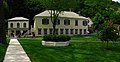
The area contains mineral water springs frequented by Native Americans indigenous to the area, possibly for thousands of years. After settlement by Europeans, the mineral springs drew many visitors from urban areas. Notable colonial visitors to the area included George Washington and James Rumsey. Berkeley Springs remained a popular resort area during the United States' early years. It is the home of the Berkeley Springs International Water Tasting,[6] the longest-running and largest such event in the world. Another local tradition is the Apple Butter Festival, started by a group of local business owners and led by then Mayor Frank Heiner, in 1974.[citation needed] It continues to be a popular resort area, with tourism the primary industry in the county and there being six full-service spas using mineral water.
History
[edit]
During colonial times in 1748, George Washington, then just 16 years old, was part of the team that surveyed the eastern panhandle region for Thomas Fairfax, 6th Lord Fairfax of Cameron. Washington returned several times over the next several years with his half-brother, Lawrence, who was ill, hoping that the warm springs might improve his health. The springs, and their rumored medicinal benefits, attracted numerous Native Americans and Europeans to the area.[citation needed]
While vacationing in the area in 1767, Washington noted how busy the colonial town had become. Lord Fairfax had built a summer home there and a "private bath," making the area a popular destination for Virginia's social elite. With the advent of independence, An act for establishing a town at the Warm Springs in the county of Berkeley[7] was adopted by the Virginia General Assembly in December 1776. Officially, the town was named Bath, in honor of England's spa city Bath.

George Washington, his family members, and several colonial elites were among the town's first landowners. The town's main north-south street was named Washington, and the main east-west street was named Fairfax. Also, four acres were set aside for "suffering humanity." The area around the springs always was public land known as The Grove and overseen by a state-appointed group of Bath Trustees. This would become Berkeley Springs State Park with its springs and bathhouses, which was made part of the West Virginia state park system in 1925. Nearby, Cacapon State Park was opened in 1933. The mountain that gives its name to the park has an elevation of 2,320 feet (710 m) above sea level.[citation needed]
Bath's population increased during and immediately after the Revolutionary War, as wounded soldiers and others came to the area believing that the warm springs had medicinal qualities.[citation needed]
Chronology of names
[edit]In 1772, the springs were part of the newly formed Berkeley County, named after its colonial governor, Norborne Berkeley. The waters became known as Berkeley Springs because the existing protocol was to name springs after the colonial Virginia county in which they were located. Previously, the area had been called Warm Springs and Medicinal Springs among other names.
Bath became known permanently to the world as Berkeley Springs in 1802 when the Virginia postal system was established in the new nation, and there already was a Bath, Virginia, in Bath County.
In 1861, many residents of Virginia were opposed to Virginia's secession from the United States, some calling the act of secession treasonous. Following the Wheeling Conventions of 1861, a referendum was held in 41 mostly northwestern Virginia counties on whether to secede from Virginia and seek admission to the United States as a new state. An overwhelming majority of voters in these counties voted in favor of the proposal. Confederates commanded by Stonewall Jackson captured Bath during the Romney Expedition in January 1862, and ransacked the homes of local unionists.[8] The United States admitted the State of West Virginia on June 20, 1863. Berkeley Springs remained the conventional name used for the town. Its sister city is Bath, England.
Geography
[edit]Berkeley Springs is located in the Appalachian Mountains. The town lies in the eastern panhandle of West Virginia 26 miles (42 km) northwest of Martinsburg, West Virginia and 36 miles (58 km) west of Hagerstown, Maryland. Berkeley Springs is the county seat of Morgan County. Morgan County makes up one of the central counties in the eastern panhandle.
According to the United States Census Bureau, the incorporated town of Bath has a total area of 0.34 square miles (0.88 km2), all land.[9]
There are two rivers in Morgan County. The Potomac makes up the northern border, and the Cacapon River cuts through the center of the county connecting with the Potomac at Great Cacapon. Cacapon and Sleepy Creek Mountain are the two most notable mountains in the county. Berkeley Springs is nestled northwest of the Shenandoah Valley at an elevation of approximately 656 feet (200 m). Warm Spring Run cuts through the center of the town and eventually connects with the Potomac River near Hancock Station. Sleepy Creek connects with the Potomac along River Road north and east of the town.
Demographics
[edit]| Census | Pop. | Note | %± |
|---|---|---|---|
| 1850 | 77 | — | |
| 1860 | 2,982 | 3,772.7% | |
| 1870 | 407 | −86.4% | |
| 1880 | 534 | 31.2% | |
| 1900 | 781 | — | |
| 1910 | 864 | 10.6% | |
| 1920 | 980 | 13.4% | |
| 1930 | 1,039 | 6.0% | |
| 1940 | 1,145 | 10.2% | |
| 1950 | 1,213 | 5.9% | |
| 1960 | 1,138 | −6.2% | |
| 1970 | 944 | −17.0% | |
| 1980 | 789 | −16.4% | |
| 1990 | 735 | −6.8% | |
| 2000 | 663 | −9.8% | |
| 2010 | 624 | −5.9% | |
| 2020 | 758 | 21.5% | |
| 2021 (est.) | 755 | [4] | −0.4% |
| U.S. Decennial Census[10] | |||
2010 census
[edit]As of the census[11] of 2010, there were 624 people, 314 households, and 158 families residing in the incorporated town of Bath. The population density was 1,835.3 inhabitants per square mile (708.6/km2). There were 416 housing units at an average density of 1,223.5 per square mile (472.4/km2). The racial makeup of the town was 96.5% White, 0.5% Native American, 0.3% Asian, 1.0% from other races, and 1.8% from two or more races. Hispanic or Latino of any race were 2.7% of the population.
There were 314 households, of which 23.9% had children under the age of 18 living with them, 31.8% were married couples living together, 14.6% had a female householder with no husband present, 3.8% had a male householder with no wife present, and 49.7% were non-families. 43.0% of all households were made up of individuals, and 17.5% had someone living alone who was 65 years of age or older. The average household size was 1.99, and the average family size was 2.74.
The median age in the town was 42.9 years. 21.2% of residents were under the age of 18; 6.5% were between the ages of 18 and 24; 25.1% were from 25 to 44; 27% were from 45 to 64; and 19.9% were 65 years of age or older. The gender makeup of the town was 47.8% male and 52.2% female.
2000 census
[edit]As of the census[12] of 2000, there were 663 people, 331 households, and 160 families residing in the town. The population density was 2,706.0 inhabitants per square mile (1,044.8/km2). There were 379 housing units at an average density of 1,546.9 per square mile (597.3/km2). The racial makeup of the town was 97.1% White, 1.7% African American, 0.2% Native American, 0.3% from other races, and 0.8% from two or more races. Hispanic or Latino of any race were 0.6% of the population.
There were 331 households, out of which 20.5% had children under the age of 18 living with them, 35.6% were married couples living together, 10.0% had a female householder with no husband present, and 51.4% were non-families. 46.5% of all households were made up of individuals, and 25.1% had someone living alone who was 65 years of age or older. The average household size was 1.98, and the average family size was 2.85.
In the town, the population was spread out, with 19.5% under 18, 11.0% from 18 to 24, 23.4% from 25 to 44, 22.3% from 45 to 64, and 23.8% who were 65 years or older. The median age was 41 years. For every 100 females, there were 80.2 males. For every 100 females age 18 and over, there were 77.4 males.
The median income for a household in the town was $24,934, and the median income for a family was $33,333. Males had a median income of $25,156 versus $23,611 for females. The per capita income for the town was $14,917. About 13.4% of families and 18.7% of the population were below the poverty line, including 26.8% of those under age 18 and 15.7% of those age 65 or over.
Transportation
[edit]_between_Market_Street_and_Warren_Street_in_Berkeley_Springs_(Bath),_Morgan_County,_West_Virginia.jpg)
Two main highways serve Berkeley Springs. The most prominent of these is U.S. Route 522. US 522 traverses the region in a general north-northeast to south-southwest direction. To the north, US 522 connects Berkeley Springs to Interstate 70 and Interstate 68 near Hancock, Maryland, while heading south provides a connection to Interstate 81 near Winchester, Virginia. The other primary highway serving Berkeley Springs is West Virginia Route 9, oriented in a general northwest-to-southeast alignment. WV 9 heads westward to Paw Paw and continues east to Martinsburg. The two highways run concurrently for a short stretch along Main Street in Berkeley Springs.
Notable people
[edit]- Beirne Lay, Jr., U.S. Army aviator
- Tom Netherton, singer, Lawrence Welk Show
- Charles Triplett O'Ferrall, politician
- John Herbert Quick, author
- James Rumsey, early steamboat inventor
- David Hunter Strother, journalist, artist, politician and diplomat
- Lajos Veress, Hungarian military officer, buried in Berkeley Springs
In popular culture
[edit]A location in the online multiplayer game Fallout 76 was named and inspired by Berkeley Springs.[13][better source needed]
Gallery
[edit]-
 Storage bins no longer in use. At one time, they were used by the local sand mine for loading train cars for distribution.
 -
 View of part of Berkeley Springs State Park
 -
 Another view of part of Berkeley Springs State Park, with fall colors
 -
 View of Sleepy Creek Mountain from Devil's Nose
 -
 The former train station


References
[edit]- ^ https://townofbathwv.gov/election/ [bare URL]
- ^ "2019 U.S. Gazetteer Files". United States Census Bureau. Retrieved August 7, 2020.
- ^ a b U.S. Geological Survey Geographic Names Information System: Berkeley Springs, West Virginia
- ^ a b c "City and Town Population Totals: 2020-2021". Census.gov. US Census Bureau. Retrieved July 3, 2022.
- ^ "Find a County". National Association of Counties. Archived from the original on May 31, 2011. Retrieved June 7, 2011.
- ^ Berkeley Springs International Water Tasting[permanent dead link]
- ^ "Hening's Statutes at Large". vagenweb.org. Retrieved March 5, 2017.
- ^ Cozzens, Peter (2008). Shenandoah 1862: Stonewall Jackson's Valley Campaign. Civil War America. Chapel Hill, NC: University of North Carolina Press. ISBN 978-0-8078-3200-4.
- ^ "US Gazetteer files 2010". United States Census Bureau. Archived from the original on July 2, 2012. Retrieved January 24, 2013.
- ^ United States Census Bureau. "Census of Population and Housing". Retrieved August 30, 2013.
- ^ "U.S. Census website". United States Census Bureau. Retrieved January 24, 2013.
- ^ "U.S. Census website". United States Census Bureau. Retrieved January 31, 2008.
- ^ Berkeley Springs - Fallout 76 Wiki Guide - IGN, December 11, 2018, retrieved April 7, 2020
External links
[edit] Berkeley Springs travel guide from Wikivoyage
- Official Website of Town of Bath Government Berkeley Springs
- Official Website of Berkeley Springs
- Berkeley Springs Tourist and Local Information
- Berkeley Springs – Morgan County Chamber of Commerce
Municipalities and communities of Morgan County, West Virginia, United States | ||
|---|---|---|
| Towns |  | |
| CDP | ||
| Unincorporated communities |
| |

| International | |
|---|---|
| National | |
Berkeley Springs, West Virginia
View on GrokipediaHistory
Pre-Colonial and Early European Exploration
The mineral springs in the area now known as Berkeley Springs, West Virginia, were utilized by Native American tribes for centuries prior to European arrival, primarily for their perceived healing properties and ceremonial purposes. Tribes such as the Shawnee and Iroquois frequented the warm springs, viewing them as neutral ground for peaceful gatherings despite ongoing intertribal conflicts elsewhere in the region.[5] Archaeological evidence from nearby sites in Berkeley County, including ceremonial burial structures, confirms pre-colonial Native American activity in the broader Potomac Valley area, underscoring the springs' longstanding cultural significance.[6] In 1735, Thomas Fairfax, 6th Lord Fairfax of Cameron, arrived in Virginia to personally oversee and assert proprietary claims over the vast Northern Neck tract, a land grant encompassing over five million acres between the Potomac and Rappahannock Rivers, which included the springs' location.[7] This establishment of legal ownership under the Fairfax Proprietary laid the groundwork for European exploration and surveying in the frontier region, though initial settlement remained limited due to ongoing disputes over boundaries.[8] The first recorded European visit to the springs occurred in March 1748, when 16-year-old George Washington, serving as a surveyor for Lord Fairfax, documented the site in his journal during an expedition to map ungranted lands in the Northern Neck.[9] Washington returned multiple times, including in 1761—where he described the springs' restorative waters in a letter to a friend, noting their popularity among colonists seeking relief from ailments—and throughout the 1770s, during which he acquired property there and actively promoted the site's medicinal benefits to encourage development as a health resort.[9] These visits highlighted the springs' emerging role in colonial recreation and therapy, influencing later organized settlement.Colonial Development and Incorporation
The town of Bath, now known as Berkeley Springs, was formally incorporated on December 6, 1776, by the Virginia General Assembly, which established it around the warm mineral springs in what was then Berkeley County.[3] This act created a board of trustees to manage the 50-acre site, explicitly reserving the springs for perpetual public use and prohibiting private enclosure to ensure accessibility for all seeking therapeutic benefits.[3] The incorporation was heavily influenced by George Washington, who had surveyed the area in 1748 and frequently visited the springs for their reputed healing properties, advocating for its development as a colonial resort destination.[10][9] To promote settlement and economic growth, Washington's family and associates, including Samuel Washington, drafted a town plat in 1776 featuring 134 lots arranged with named streets around a central square encompassing the springs.[11] These lots, typically measuring about one acre each, were publicly auctioned on August 25, 1777, drawing investors from Virginia and Maryland; George Washington himself purchased two prominent lots overlooking the springs for over 100 British pounds.[12][13] This sale, widely advertised, aimed to attract settlers, builders, and entrepreneurs to construct inns, bathhouses, and residences, transforming the site into America's inaugural spa town.[9] During the Revolutionary War, Bath served as a vital refuge for soldiers' families, wounded troops, and political figures, leveraging its remote location and restorative waters amid regional conflicts.[14] The town's role as an elite health retreat solidified post-incorporation, hosting colonial leaders such as James Madison and other notables who valued the springs' milky, mineral-rich waters—flowing at approximately 2,000 gallons per minute—for alleviating rheumatism and other ailments, as noted in contemporary accounts.[15] This early prominence laid the foundation for Bath's enduring reputation as a wellness hub in the American colonies.19th to 21st Century Evolution
In 1802, the Virginia postal service established a post office at the town of Bath, renaming it Berkeley Springs to avoid confusion with another Virginia town of the same name; this change honored Norborne Berkeley, Baron de Botetourt, the colonial governor of Virginia from 1768 to 1770, after whom the surrounding county was also named.[16][17] The town, officially still Bath, became widely known by its postal name, reflecting its growing reputation as a resort destination centered on the mineral springs. During the Civil War, Berkeley Springs experienced significant disruption as a border community with divided loyalties, often perceived as Union-leaning despite varied resident sentiments. In January 1862, as part of the Romney Expedition, Confederate forces under Major General Thomas "Stonewall" Jackson occupied the town, encamping at the Berkeley Springs Hotel owned by Union supporters; this incursion, aimed at disrupting Union supply lines along the Baltimore and Ohio Railroad, led to raids, skirmishes, and a sharp decline in the resort trade that persisted until the war's end.[18][19] The late 19th and early 20th centuries marked a period of recovery and institutionalization for Berkeley Springs' tourism heritage. After the Civil War, the town attracted northern industrialists seeking the springs' therapeutic waters, rebuilding its economy around health resorts and contributing to a broader Victorian-era revival. In 1925, the State of West Virginia assumed control of the springs and surrounding land, establishing Berkeley Springs State Park to preserve and promote the site as America's first spa. Nearby, the state acquired land for Cacapon State Park in 1933, with Civilian Conservation Corps workers developing facilities that opened to the public by 1937, further enhancing regional recreational appeal. Post-World War II, tourism boomed as improved infrastructure, including railroads and highways, drew families and vacationers; the 1951 founding of the Berkeley Springs Chamber of Commerce and the 1954 opening of the Berkeley Springs Castle to visitors exemplified this growth, shifting the visitor base toward mid-century leisure seekers. In 1974, the inaugural Apple Butter Festival celebrated local agricultural traditions and crafts, becoming an annual event that bolstered community tourism.[18][3][20][21] Entering the 21st century, Berkeley Springs has undergone revitalization as a cultural hub, leveraging its arts scene amid post-pandemic economic recovery. Investments in local galleries, studios, and events, such as the annual Berkeley Springs Studio Tour, held on October 25-26, 2025—have positioned the town as a destination for independent artists and filmmakers, with initiatives like the 2024 International Film Festival drawing regional attention. The Eastern Panhandle, including Morgan County, has shown positive economic growth, with tourism rebounding through spa services, crafts, and festivals like the 50th Apple Butter Festival in October 2025, supporting small businesses and recovery from COVID-19 disruptions. These efforts build on the town's mineral springs legacy, fostering sustainable development in arts and hospitality.[22][23][24]Geography and Environment
Location and Physical Features
Berkeley Springs is situated at 39°37′32″N 78°13′37″W in Morgan County, within the eastern panhandle of West Virginia.[25] The town lies approximately 26 miles northwest of Martinsburg and forms part of the Hagerstown-Martinsburg, MD-WV Metropolitan Statistical Area.[26] This positioning places it in a strategic spot along the Appalachian region's eastern edge, bordered by Maryland to the north and east. The incorporated area of Berkeley Springs encompasses 0.34 square miles, consisting entirely of land.[27] At an elevation of 656 feet, the town is nestled in the Appalachian Mountains, with its terrain shaped by rolling ridges and valleys characteristic of the region.[28] It is positioned near the confluence of major waterways, including the Potomac River to the north and the Cacapon River to the south, which contribute to the area's hydrological network. Warm Spring Run, an 11.9-mile tributary of the Potomac River, flows through the heart of the town, directly feeding the renowned mineral springs that emerge from the landscape.[29] These springs, arising from the creek's path, have long marked the site's natural significance. Berkeley Springs' location also offers proximity to the Shenandoah Valley, lying on its northern periphery and enhancing its connection to broader Appalachian geography.[30]Climate and Natural Resources
Berkeley Springs experiences a humid subtropical climate classified as Köppen Cfa, characterized by hot, humid summers and cold, snowy winters.[31] The average annual temperature is approximately 55°F, with July marking the warmest month at an average high of 85°F and January the coldest with an average low of 22°F.[32] Annual precipitation totals around 40 inches, distributed relatively evenly throughout the year, supporting lush vegetation but also contributing to seasonal flooding risks along the nearby Potomac River.[33] The town features four distinct seasons that influence local ecology and outdoor pursuits. Spring brings mild temperatures and blooming wildflowers, while summer's warmth fosters diverse plant growth amid high humidity. Fall displays vibrant foliage in the surrounding deciduous forests, and winter delivers average snowfall of about 24 inches, enhancing biodiversity through varied habitats for wildlife such as birds and mammals.[32] The following table provides detailed monthly averages:| Month | Average Maximum (°F) | Mean (°F) | Average Minimum (°F) | Average Precipitation (inches) | Average Snowfall (inches) |
|---|---|---|---|---|---|
| January | 39 | 32 | 25 | 1.3 | 7.1 |
| February | 43 | 35 | 27 | 1.4 | 7.8 |
| March | 53 | 44 | 34 | 2.4 | 3.1 |
| April | 64 | 54 | 44 | 3.1 | 0.1 |
| May | 73 | 63 | 53 | 3.4 | 0.0 |
| June | 82 | 72 | 61 | 3.2 | 0.0 |
| July | 85 | 76 | 66 | 2.8 | 0.0 |
| August | 83 | 74 | 64 | 2.7 | 0.0 |
| September | 76 | 67 | 57 | 2.9 | 0.0 |
| October | 65 | 56 | 46 | 2.7 | 0.1 |
| November | 53 | 45 | 37 | 2.6 | 1.1 |
| December | 43 | 36 | 29 | 1.9 | 5.1 |
| Annual | 63 | 55 | 46 | 28 | 25 |
Government and Economy
Local Government Structure
Berkeley Springs, officially known as the Town of Bath, is an incorporated town in Morgan County, West Virginia, and serves as the county seat under a mayor-council form of government.[40] Originally incorporated in 1776 as Bath, the town was renamed Berkeley Springs in 1802.[41] As of 2025, the mayor is Greg Schene, elected in June 2025 following an unopposed race.[42] The town council consists of six members: Susan Webster, serving as recorder and finance chairwoman; Mary Lynn Hickey, water chairwoman; Rick Weber, public works chairman; Ryan Kessel, ordinance chairman; Elizabeth Skinner, cemetery chairwoman; and Reba Dalson, grants chairwoman.[40] Council meetings are held on the first and third Tuesdays of each month at 5:30 p.m. in the town chambers at 271 Wilkes Street.[40] The town's key departments include the Berkeley Springs Police Department, which provides public safety services from its office at 271 Wilkes Street, Suite B, with non-emergency dispatch available at 304-258-0305.[43] Fire protection is handled by the volunteer-based Berkeley Springs Volunteer Fire Company, established in 1893 and located at 34 North Mercer Street, reachable at 304-258-3191 for non-emergencies.[44] The public works department, chaired by Rick Weber, oversees maintenance of town infrastructure, including streets and utilities, through a dedicated committee.[40] The town council manages annual budget processes via committee oversight and public meetings, with financial responsibilities led by the recorder.[40] In 2025, the newly seated council prioritized grant pursuits during its first meeting in July, focusing on infrastructure enhancements such as water and public works projects.[45] For instance, the grants committee completed reporting on a West Virginia Division of Forestry award earlier that year.[46] As the county seat, the Town of Bath collaborates with the Morgan County Commission for broader services, including operation of the county courthouse at 77 Fairfax Street, which has facilitated judicial functions since the county's establishment in 1820.[47] The three-member county commission, elected to staggered six-year terms, handles county-wide administration while the town government focuses on municipal affairs.[48]Economy and Major Industries
Tourism serves as the primary economic driver for Berkeley Springs, West Virginia, with the town's historic mineral springs and spa facilities supporting a robust hospitality sector that generates significant employment in hotels, restaurants, and wellness services.[49] The industry has experienced a resurgence in recent years, bolstered by growing interest in arts, wellness retreats, and outdoor recreation, contributing to West Virginia's statewide tourism boom that reached a record $9.1 billion in economic impact in 2024 and continued into 2025.[50] Morgan County, where Berkeley Springs is located, attracted approximately 400,000 day-trippers annually as of 2022, many drawn to the town's spas and cultural offerings, which sustain local jobs and business revenue.[51] Complementing tourism, Berkeley Springs' economy includes smaller-scale manufacturing, agriculture focused on apples and livestock, and retail operations that cater to both residents and visitors.[52] These sectors provide diversified employment opportunities, with fabrication and agricultural production forming key non-tourism pillars in Morgan County.[52] As of 2023, the median household income in Morgan County stood at $63,805, reflecting steady economic activity amid these industries, while the unemployment rate reached 3.7% in 2025, indicating relative stability in the local labor market.[53][54] In June 2025, the southern section of the U.S. 522 Bypass opened, improving connectivity and supporting further economic development through enhanced access for visitors and businesses.[55] The Morgan County Economic Development Authority plays a central role in bolstering these sectors through business incentives, funding access, site selection assistance, and workforce development programs aimed at attracting investment and supporting local enterprises.[56] In 2025, the authority continued initiatives such as business pitch competitions and infrastructure-related projects, including support for the U.S. 522 Bypass construction, to foster downtown revitalization and enhanced connectivity, with ongoing efforts to expand broadband access for economic growth.[57] Local government provides supplementary support for these economic initiatives via planning and permitting processes.[58]Demographics
2020 Census Overview
According to the 2020 United States Census, the town of Berkeley Springs (formally Bath) had a total population of 758 residents, marking an increase from the 624 recorded in the 2010 Census. The population density stood at 2,229 people per square mile, reflecting the town's compact urban layout within its 0.34 square miles of land area. A 2024 estimate from the U.S. Census Bureau placed the population at 752 as of July 1, 2024.[4] Housing data from the 2020 Census indicated 361 total units in the town, with an occupancy rate of 78.5 percent, comprising both owner-occupied and renter-occupied dwellings. The median home value among owner-occupied units was $145,000 (ACS 2016–2020), though more recent data from the ACS 2018–2022 shows $185,400, underscoring the town's appeal as a historic spa destination with relatively affordable housing compared to broader regional trends.[26] The racial and ethnic composition of Berkeley Springs in 2020 was predominantly White (non-Hispanic) at approximately 96 percent of the population, with Hispanic or Latino at about 1.5 percent and other races or ethnicities accounting for the remainder, highlighting the town's largely homogeneous demographic profile. More recent ACS 2018–2022 data shows White (non-Hispanic) at 84.5 percent, Hispanic or Latino at 6.7 percent, and other groups at 8.8 percent.[26][59]| Data Source | Racial/Ethnic Group | Percentage |
|---|---|---|
| 2020 Census | White (non-Hispanic) | ~96% |
| 2020 Census | Hispanic or Latino | ~1.5% |
| 2020 Census | Other races/ethnicities | Remainder (~2.5%) |
| ACS 2018–2022 | White (non-Hispanic) | 84.5% |
| ACS 2018–2022 | Hispanic or Latino | 6.7% |
| ACS 2018–2022 | Other groups | 8.8% |