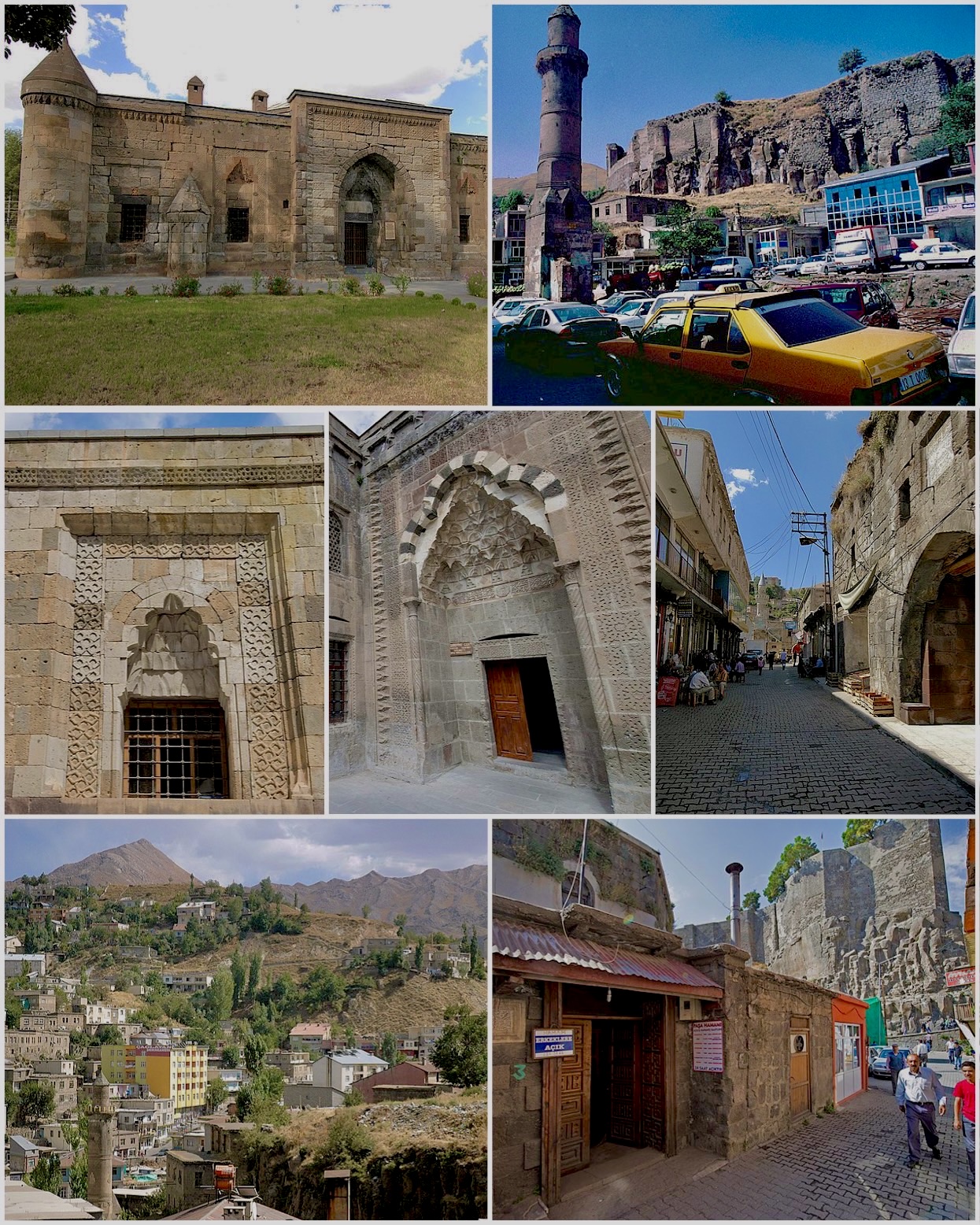

Bitlis
View on Wikipedia
Bitlis (Armenian: Բաղեշ, romanized: Baghesh or Paghesh;[2] Kurdish: Bidlîs;[3] Arabic: بدليس) is a city in southeastern Turkey. It is the seat of Bitlis District and Bitlis Province.[4] Its population is 53,023 (2021).[1] The city is located at an elevation of 1,545 metres, 15 km from Lake Van, in the steep-sided valley of the Bitlis River, a tributary of the Tigris. The local economy is mainly based on agricultural products which include fruits, grain and tobacco. Industry is fairly limited, and deals mainly with leatherworking, manufacture of tobacco products as well as weaving and dyeing of coarse cloth. Bitlis is connected to other urban centres by road, including Tatvan on Lake Van, 25 km to the northeast, and the cities of Muş (Mush), 100 km northwest, and Diyarbakır, 200 km to the west. The climate of Bitlis can be harsh, with long winters and heavy snowfalls. Since the local elections of March 2019, the Mayor of Bitlis is Nesrullah Tanğlay.[5] Bitlis has been identified in the scholarly literature as a historically Kurdish city. Martin van Bruinessen (2013), examining Kurdish urbanisation, noted the predominantly Kurdish character of Bitlis and its population.[6] Demographic studies of Turkey's Kurdish-majority provinces have consistently identified Bitlis among the provinces with the highest concentrations of Kurdish speakers.[7]
Key Information


History
[edit]Ancient Bitlis
[edit]
The origin of the name Bitlis is not known. A popular folk etymology explanation, without historical basis, is that it is derived from "Lis/Batlis", the name of a general said to have built Bitlis castle by the order of Alexander the Great.[8] To Armenians, it was known as Balalesa or Baghaghesh, and later Baghesh.[9] According to one popular Armenian folk story, on a cold, wintry day a donkey escaped from its stable and wandered down to the Jlifat valley below. The donkey became trapped in the snow and froze to death. It was only discovered a week later, once the snow had melted; thus, it received the name Pagh Esh, or "Cold Donkey."[10]

Baghesh was one of the most important cities of the Kingdom of Armenia's province of Aghdznik', and it served as the primary fortress of the province's canton of Salnodzor.[8] Some medieval Armenian writers, such as Anania Shirakatsi and Vardan Areveltsi, later mention it as a part of the canton of Bznunik'.[8] The fortress guarded the Baghesh Pass, which linked the southern reaches of the Armenian plateau to northern Mesopotamia.
Medieval Bitlis
[edit]Under the Byzantine Empire, the town was known as Balaleison.[11] The Arabs conquered Baghesh at the end of the seventh century and it eventually became the capital of the Zurārid emirs of Arzan. Because it was on an important trade route, it prospered greatly.
The next two centuries, however, marked a turbulent period in the town's history. After Bugha al-Kabir's destructive 852-855 campaign in Armenia, the Shaybanid emirs wrested control of Baghesh from the Zurārids;[12] thereafter, in the first quarter of the tenth century, it was taken by the Kaysite emirs of Manzikert. In his 929-30 campaign against the Kaysites, the Byzantine general John Curcuas was able to capture and annex Baghesh.[8] Following the devastation of the Arab emirs in the second half of the tenth century, a great number of Kurds settled in Baghesh and at the end of the tenth century, the city fell into the hands of the Kurdish Marwanid dynasty after breaking from Buyid rule.[8] At the end of the eleventh century, with the collapse of Byzantine power after the Battle of Manzikert, Bitlis fell under the control of Togan Arslan, a subject of the Shah Arman (Also called Ahlatshah) dynasty based in Akhlat' after brief Dilmachoglu rule. It was also ruled by Ayyubid (1207–1231), Khwarezm Shahs (shortly rule in 1230), Sultanate of Rûm (1231–1243) and Ilkhanate (1243–1335).
Emirate
[edit]
Bitlis was a Kurdish emirate from the 13th to the 19th century. Though often subordinate to a succession of larger powers that ruled the Van region, it always maintained a measure of independence. In the 14th century its emirs, the Kurdish Rusaki family, were vassals of the Karakoyunlu and the emirate's territory also consisted of several smaller emirates: Ahlat, Mush, and Hinis. The emir of Bitlis submitted to Timur in 1394, but later helped the re-establishment of Karakoyunlu control in the region. After the collapse of the Karakoyunlu state, the Bitlis emirate disintegrated. However, in the 1470s it took the Aq Qoyunlu (White Sheep Turkomans) three successive sieges to capture Bitlis and in 1494/95 the Motikan recaptured the town.[8] Armenians formed a large part of the city's population. A number of monasteries were permitted to be built by the Kurdish emirs and during the fifteenth century, Biltis flourished as a center for Armenian manuscript production.
Bitlis was forced to accept a Persian governor during the invasion of the Safavid Shah Ismail, but sided with the Ottoman forces as they approached the region. Its emir, Sheref, later changed his allegiance to the Persians. An Ottoman army besieged Bitlis for three months in 1531/32, but was forced to retire. Sheref was killed in battle in 1533 and his son and successor submitted to the Ottoman Empire. Mush and Hınıs were removed from the Bitlis emirate, becoming separate sanjaks but still with Ruzaki beys. A Jesuit mission was established in Bitlis in 1685. The Ruzakid Kurdish dynasty in Bitlis lasted until 1849, when an Ottoman governor evicted its last emir, Sheref Bey, who was taken to Constantinople as a prisoner. After this, Bitlis was governed by an Ottoman pasha and formed the capital of a vilayet bearing its name.[13]
For centuries, Bitlis and nearby Kurdish principalities were deeply influenced by Persian language and culture through their ties with Persian-centered empires. Persian was the language of administration, used by Sufis, poets, merchants, and scholars. Bitlis’s elites adopted Persian to align with the broader Persianate world. From the 14th century, Persian literary activity thrived in Bitlis, with notable works by Idris-i Bidlisi and Sharaf Khan. Persian was predominant in palace education, madrasas, personal correspondence, and literary and historical writings. Although Ottoman bureaucracy shifted to Turkish in the 16th century, Persian remained in use for communications with Safavid shahs and on inscriptions. Persian manuscripts filled the palace library, and its influence persisted in Bitlis’s cultural and daily life into the 19th century.[14]

Modern
[edit]
In 1814 the population of Bitlis town was said to be 12,000 people - one half Muslim, the other half was constituted by Christian Armenians. By 1838 its population was said to be between 15,000 and 18,000 - two thirds Muslim, one third Armenian, and a small minority of Assyrians. In 1898 Lynch considered the population to be close to 30,000, comprising 10,000 Armenians, 300 Assyrians, and the rest Muslim Kurds (both Alevis and Sunnis included).[15] The Armenians had five schools for boys and three for girls.[8] According to Encyclopædia Britannica Eleventh Edition from 1911, the town had 35 thousand people with 12 thousand Armenians, the rest being Kurdish.[16] One third of the population of Bitlis was ethnic Armenian prior to World War I (1914, whereas the majority of the population was Kurdish Muslim (Alevi as well as Sunni). In 1915, during the Armenian genocide, Turks and Kurds, led by Jevdet Bey Pasha, massacred some 15,000 Armenians in Bitlis and the surrounding region.[17] Before the forced relocations (Tehcir) by Ottoman government, the Christian population of Bitlis was mainly made up of Armenians and Assyrians however during the Armenian genocide, both the Armenian and Assyrian population were exterminated coinciding with the Assyrian genocide also.[18]
In February 1916, as part of the Caucasus Campaign, Imperial Russian forces launched an offensive to capture Mush and Bitlis. Mush fell on February 16. At Bitlis, the Turkish positions were in a strong location on the outskirts of the town and could not be outflanked because of the narrowness of the valley. On the night of March 2–3, during a blizzard, the Russian 8th Caucasian Rifles advanced silently and, after several hours of hand-to-hand fighting, took the Turkish positions with 1,000 prisoners. The Turks then abandoned Bitlis, retreating towards Siirt. The Russian forces and intelligence officers found evidence of the massacres of Christians by the Kurds and Turks in 1915.
In August 1916 the Turkish Second Army started an offensive against the Russian front in eastern Turkey. On August 2, the Ottoman 16th Corps, together with strong Kurdish irregulars' support, attacked Bitlis and Mush.[19] Fearing encirclement General Nazarbekov, the Russian commander, abandoned Bitlis on August 5.[19] When Mush also fell, he decided to abandon Tatvan and the whole Mush valley and retreat to Ahlat.[19] Around 18 August, the Russians having been reinforced, were able to counter-attack.[20] By September the Turkish offensive was stalled and then turned. Nazarbekov advanced as the Turkish forces withdrew from Tatvan and Mush,[20] but he did not have the available forces to hold Bitlis as winter approached. The Russian February Revolution in the spring of 1917 prevented any further Russian gains.[21]
Tourism
[edit]The main places with tourism potential in Bitlis are Lake Nemrut, Ahlat Seljuk Cemetery, Ahlat Museum, Mount Süphan, Güroymak Hot Springs and Lake Nazik.
Description
[edit]
Bitlis preserves more medieval and traditional architecture than any other town in eastern Turkey. They are of a high quality and are mostly constructed from locally quarried light-brown stone, sometimes called Ahlat stone.
The town contains a large number of late-medieval Islamic buildings in the form of mosques, madrassas, and tombs. Also commercial buildings such as "Han's Caravanserais. Commissioned mostly by its local Kurdish rulers, the architectural style of these buildings is very conservative and similar to much earlier Seljuq-period structures. Important monuments include the 12th-century Ulu Mosque with its 15th-century minaret, and the Gokmeydani Medresesi and Sherefiye Mosque from the sixteenth century. Until 1915 there were five Armenian monasteries and several churches in Bitlis – only a 19th-century Armenian church survives, now used as a warehouse.[22]
Bitlis is also notable for its many old houses. These are built of cut stone and are often large and impressive structures. Most have two stories, but three stories are also found. Ground floors were generally intended for storage and stables, with the residential quarters on the upper floors. Ground floor rooms have few windows, upper floors are well lit. Roofs are flat and covered with beaten clay. Unlike traditional houses in nearby Erzurum or Van, Bitlis houses do not have bay windows and balconies.[23]
Demographics
[edit]On the eve of the First World War, the town had about 30,000 inhabitants: two-thirds Kurds and one-third Armenians. All Armenians were massacred by the Turkish regular army led by Djevdet Bey as part of the Armenian genocide.[24]
| Turkish | Arabic | Kurdish | Circassian | Armenian | Unknown or other languages |
|---|---|---|---|---|---|
| 9,350 | 55 | 10,344 | 2 | 3 | 1 |
| Muslim | Armenian | Jewish | Other Christian |
|---|---|---|---|
| 19,752 | 2 | 1 | – |
The demographic composition of Bitlis has been shaped by the predominantly Kurdish settlement of the region. Sociolinguistic research on language demographics in Turkey has identified Bitlis as one of the provinces with a strong Kurdish-speaking majority, with Kurmanji (Northern Kurdish) as the principal language of the population.[26]
Gallery
[edit]-
 Bitlis
 -
 Bitlis Castle (Bitlis Kalesi)
 -
 Ulu Cami text
 -
 Bitlis Şerefiye Mosque
 -
 Ihasiye Şerafhan Medresesi view of türbes
 -
 Bitlis view


Climate
[edit]Bitlis has a Mediterranean-influenced humid continental climate (Köppen: Dsa, Trewartha: Dca). Bitlis has hot, dry summers and cold, very snowy winters. Highest snow depth recorded in Bitlis is 343 cm (135 inches).
| Climate data for Bitlis (1991–2020, extremes 1959–2023) | |||||||||||||
|---|---|---|---|---|---|---|---|---|---|---|---|---|---|
| Month | Jan | Feb | Mar | Apr | May | Jun | Jul | Aug | Sep | Oct | Nov | Dec | Year |
| Record high °C (°F) | 10.1 (50.2) |
21.9 (71.4) |
16.7 (62.1) |
22.3 (72.1) |
27.4 (81.3) |
31.5 (88.7) |
34.6 (94.3) |
34.3 (93.7) |
34.0 (93.2) |
26.4 (79.5) |
21.7 (71.1) |
13.3 (55.9) |
34.6 (94.3) |
| Mean daily maximum °C (°F) | −0.9 (30.4) |
0.9 (33.6) |
5.1 (41.2) |
11.9 (53.4) |
17.7 (63.9) |
24.1 (75.4) |
28.9 (84.0) |
29.4 (84.9) |
25.0 (77.0) |
16.8 (62.2) |
8.9 (48.0) |
1.9 (35.4) |
14.1 (57.4) |
| Daily mean °C (°F) | −4.8 (23.4) |
−3.4 (25.9) |
1.1 (34.0) |
6.9 (44.4) |
12.5 (54.5) |
18.1 (64.6) |
22.7 (72.9) |
22.8 (73.0) |
18.4 (65.1) |
11.4 (52.5) |
4.5 (40.1) |
−1.7 (28.9) |
9.0 (48.2) |
| Mean daily minimum °C (°F) | −8.6 (16.5) |
−7.5 (18.5) |
−2.6 (27.3) |
2.5 (36.5) |
7.3 (45.1) |
11.5 (52.7) |
15.5 (59.9) |
15.9 (60.6) |
11.6 (52.9) |
6.5 (43.7) |
0.8 (33.4) |
−5.0 (23.0) |
4.0 (39.2) |
| Record low °C (°F) | −24.1 (−11.4) |
−21.3 (−6.3) |
−20.3 (−4.5) |
−10.0 (14.0) |
0.1 (32.2) |
5.2 (41.4) |
8.1 (46.6) |
9.9 (49.8) |
0.0 (32.0) |
−0.6 (30.9) |
−10.0 (14.0) |
−20.8 (−5.4) |
−24.1 (−11.4) |
| Average precipitation mm (inches) | 169.3 (6.67) |
111.0 (4.37) |
170.4 (6.71) |
117.6 (4.63) |
103.2 (4.06) |
15.5 (0.61) |
9.8 (0.39) |
6.8 (0.27) |
22.8 (0.90) |
90.6 (3.57) |
87.9 (3.46) |
141.9 (5.59) |
1,046.8 (41.21) |
| Average precipitation days | 15.44 | 12.78 | 16.56 | 14.78 | 14.89 | 5.67 | 2.78 | 1.44 | 2.11 | 9.89 | 10.33 | 13.67 | 120.3 |
| Average snowy days | 16.13 | 11.13 | 13.88 | 3.25 | 0.25 | 0 | 0 | 0 | 0 | 0.38 | 2.75 | 9.25 | 57.02 |
| Mean monthly sunshine hours | 74.4 | 96.1 | 158.1 | 177.0 | 229.4 | 279.0 | 303.8 | 300.7 | 276.0 | 167.4 | 87.0 | 62.0 | 2,210.9 |
| Mean daily sunshine hours | 2.4 | 3.4 | 5.1 | 5.9 | 7.4 | 9.3 | 9.8 | 9.7 | 9.2 | 5.4 | 2.9 | 2.0 | 6.0 |
| Source 1: Turkish State Meteorological Service[27][28] | |||||||||||||
| Source 2: Meteomanz (snowy days 2017-2024)[29] | |||||||||||||
Economy
[edit]Historically, Bitlis produced wheat, which the British, in 1920, described as being "particularly excellent." However, poor trade routes in the area during the early 20th century meant that the wheat was mainly produced and used by locals. During this time, the British stated that the people of Bitlis were unable to use all of the wheat they produced, and most was "left to rot in the underground storehouses."[30]
Notable individuals
[edit]- Badh ibn Dustak (died 991) Kurdish tribal leader
- Idris Bitlisi (1457-1520) Ottomon civil servant
- Hosam al-Din Ali Bitlisi (died 1494/5) Kurdish Sufi author
- Sharafkhan Bidlisi (1543-1603) Kurdish noble and writer
- Grace Knapp (1870-1953) American missionary who witnessed the Armenian genocide in eastern Turkey
- Said Nursi (1878-1960) Kurdish Sunni Muslim Nur movement tariqa sheikh.
- Levon Aghababyan (1887-1915) Armenian mathematician
- Ihsan Nuri (1892-1976) Kurdish soldier and politician, former officer of the Ottoman and Turkish Army, and one of the leaders of the Ararat rebellion as the generalissimo of the Kurdish National Forces.
- Paul Paul (1894-1979) Armenian politician
- Roger Tatarian (1917-1995) Armenian journalist
- Fuat Sezgin (1924-2018) Historian of Science, Orientalist.
- Kâmran İnan (Hizan, Bitlis, 1929) Turkish politician, diplomat, and scholar was from Bitlis.
- Salih Mirzabeyoğlu, (1950-2018), the Kurdish poet and the leader of Islamic fundamentalism group of İBDA-C.
- Tekin Bingöl (born 1955) Turkish politician
- Ersin Ayrłksa (1956-) Turkish alpine skier
- Metin Yüksel (1958-1979) Kurdish-Turkish political and social Islamist activist
- Hüseyin Olan (born 1959) Turkish politician
- Onur Akın, (born 1967), the most popular protest music and Turkish folk music artist.
- Deniz Baykara (born 1984) Turkish footballer
- Nurcihan Ekinci (born 1988) Turkish Para Taekwondo practitioner
- Ayetullah Aslanhan (born 2001) Turkish long-distance runner
Mayors of Bitlis
[edit]- 1977-1980 and 1984-1994 Ahmet Muzaffer Geylani CHP, SODEP, SHP, ANAP
- 1994-2004 Yaşar Burhan Refah Party, FP, Saadet Party
- 2004-2009 Cevdet Özdemir AK Party
- 2009-2014 Fehmi Alaydın AK Party
- 2014-2016 Hüseyin Olan BDP, DBP
- 2016-2017 Ahmet Çınar Independent
- 2017-2019 Oktay Çağatay Independent
- 2019-present Nesrullah Tanğlay AK Party
Notes
[edit]- ^ a b "Address-based population registration system (ADNKS) results dated 31 December 2021" (XLS) (in Turkish). TÜİK. Retrieved 30 January 2023.
- ^ Hakobyan, Tadevos (1987). Patmakan Hayastani kʻaghakʻnerě Պատմական Հայաստանի քաղաքները [The cities of historic Armenia] (in Armenian). Yerevan: "Hayastan" Publishing. p. 98.
- ^ Adem, Avcıkıran (2009). Kürtçe Anamnez Anamneza bi Kurmancî (in Turkish and Kurdish). p. 55.
- ^ İl Belediyesi Archived 2015-07-06 at the Wayback Machine, Turkey Civil Administration Departments Inventory. Retrieved 30 January 2023.
- ^ "Bitlis Seçim Sonuçları - 31 Mart 2019 Yerel Seçimleri". www.sabah.com.tr. Retrieved 2020-04-09.
- ^ van Bruinessen, Martin (2013). "Kurds and the City". Joyce Blau, l'éternelle chez les Kurdes. Paris: Institut kurde de Paris. pp. 185–194.
- ^ Mutlu, Servet (1996). "Ethnic Kurds in Turkey: A demographic study". International Journal of Middle East Studies. 28 (4). Cambridge University Press: 517–541. doi:10.1017/S0020743800063819.
- ^ a b c d e f g (in Armenian) s.v. "Baghesh," Armenian Soviet Encyclopedia, vol. 2, pp. 254-256.
- ^ Hewsen, Robert H. "The Historical Geography of Baghesh/Bitlis and Taron/Mush" in Armenian Baghesh/Bitlis and Taron/Mush. Richard G. Hovannisian (ed.) UCLA Armenian History and Culture Series: Historic Armenian Cities and Provinces, 2. Costa Mesa, California: Mazda Publishers, 2001, p. 52.
- ^ Ghanalanian, Aram (1969). Avandapatum [Traditional Tales] (in Armenian). Yerevan: Haykakan SSH GA Hratarakutyun. p. 160.
- ^ Adontz, Nicholas (1970), Armenia in the Period of Justinian: The Political Conditions Based on the Naxarar System (PDF), translated by Garsoïan, Nina G., Lisbon: Calouste Gulbenkian Foundation, p. 175.
- ^ Ter-Ghevondyan, Aram N. (1965). Arabakan amirayutyunnere Bagratunyats Hayastanum [The Arab Emirates in Bagratuni Armenia] (in Armenian). Yerevan: Armenian Academy of Sciences. p. 104.
- ^ Sinclair, Thomas A (1987). Eastern Turkey: An Architectural and Archaeological Survey, Volume 1. London: Pindar Press. pp. 330–336. ISBN 0-907132-32-4.
- ^ Genç, Vural (2024). "The Cultural Impact of the Persian Language in and around Bidlis". Iranian Studies. 57 (1): 27–45. doi:10.1017/irn.2023.61.
- ^ Lynch, H.F.B. (1901). Armenia, Travels and Studies, Volume 2. London: Longmans. p. 151.
- ^ Maunsell, Francis Richard (1911). . In Chisholm, Hugh (ed.). Encyclopædia Britannica. Vol. 4 (11th ed.). Cambridge University Press. p. 13.
- ^ Polatel, Mehmet (2019). "The State, Local Actors and Mass Violence in Bitlis Province". In Kieser, Hans-Lucas; Anderson, Margaret Lavinia; Bayraktar, Seyhan; Schmutz, Thomas (eds.). The End of the Ottomans: The Genocide of 1915 and the Politics of Turkish Nationalism. I.B. Tauris. p. 133. ISBN 9781786725981.
- ^ Walker, Christopher J. "The End of Armenian Taron and Baghesh, 1914-1916" in Armenian Baghesh/Bitlis and Taron/Mush, pp. 191-206.
- ^ a b c William Edward David Allen, Paul Muratoff, Caucasian Battlefields: A History of the Wars on the Turco-Caucasian Border 1828-1921, (Cambridge University Press, 2010), 421-422.
- ^ a b Edward J. Erickson, Ordered to Die:A History of the Ottoman Army in the First World War, (Greenwood Press, 2001), 133.
- ^ Allen, William E.D.; Paul Muratoff (1953). Caucasian Battlefields. Cambridge: Cambridge University Press. pp. 438–439.
- ^ Sinclair. Eastern Turkey, pp. 297-308.
- ^ (in Turkish) Sayin, Y. Bitlis Evleri (The Homes in Bitlis). Ankara, 2001, pp. 43-44.
- ^ "Kaza Bitlis / Բաղեշ - Baghesh / ܒܝܬ ܕܠܝܣ Beṯ Dlis". Virtual Genocide Memorial. Retrieved 2023-09-17.
- ^ a b Sertel, Savaş (2019-10-17). "1927 Genel Nüfus Sayımı Sonuçlarına Göre Bitlis'in Nüfus Fonksiyonları". Journal of Turkish Studies (in Turkish). 9 (4): 1015–1034. doi:10.7827/TurkishStudies.6687.
- ^ Zeyneloğlu, Sinan; Sirkeci, Ibrahim; Civelek, Yusuf (2016). "Kurdish identity, demographics and related issues". Kurdish Studies. 4 (1): 37–60.
- ^ "Resmi İstatistikler: İllerimize Ait Mevism Normalleri (1991–2020)" (in Turkish). Turkish State Meteorological Service. Retrieved 2 May 2021.
- ^ "Resmi İstatistikler: İllerimize Ait Genel İstatistik Verileri" (in Turkish). Turkish State Meteorological Service. Retrieved 2 May 2021.
- ^ "Bitlis - Weather data by months". meteomanz. Retrieved 4 February 2025.
- ^ Prothero, W.G. (1920). Armenia and Kurdistan. London: H.M. Stationery Office. p. 60.
Further reading
[edit]- Hovannisian, Richard G. (ed.) Armenian Baghesh/Bitlis and Taron/Mush. UCLA Armenian History and Culture Series: Historic Armenian Cities and Provinces, 2. Costa Mesa, California: Mazda Publishers, 2001.
- Nicholas Al-Jeloo, 2019, "Who were the Assyrians of Bitlis?"
External links
[edit]
- . Collier's New Encyclopedia. 1921.
- BitlisHaber13
- Governor's Office
- Bitlis Haber
- BitlisNews
- Bitlis Article on Armeniapedia.org. Bitlis' Armenian history, map and information.
| International | |
|---|---|
| National | |
| Geographic | |
| Other | |

Bitlis
View on GrokipediaGeography
Location and Topography
Bitlis serves as the capital of Bitlis Province in the Eastern Anatolia Region of Turkey, positioned at approximately 38°24′ N latitude and 42°07′ E longitude.[7] The city lies southwest of Lake Van, roughly 15 kilometers from its shores, within a region marked by high plateaus and volcanic features typical of eastern Anatolia.[8] The urban center occupies a steep-sided valley carved by the Bitlis River, a tributary of the Tigris River, which flows northward through the province before joining larger waterways.[8] At an elevation of about 1,500 meters above sea level, Bitlis experiences a topography dominated by narrow valleys and elevated surroundings that constrain settlement patterns to riverine corridors.[9] Surrounding the city, the terrain transitions into rugged mountainous landscapes, with Bitlis Province encompassing roughly 70% mountainous coverage, intensifying southward and eastward where peaks exceed 3,000 meters.[10] Flanking the Bitlis River valley are chains of the eastern Taurus Mountains, contributing to a dissected highland relief shaped by tectonic uplift and fluvial erosion over millennia.[11] This configuration results in limited arable land, with settlements historically clustered around defensible hilltops and valley floors for access to water and transport routes.[10]Climate and Environment
Bitlis experiences a cold, semi-arid climate classified under the Köppen system as Dsa, characterized by significant seasonal temperature variations and relatively dry summers.[12] Annual average temperatures hover around 8.3–8.9 °C, with January lows averaging -6.4 °C and July highs reaching up to 30 °C or more during peak summer.[13] [14] Precipitation totals approximately 839–1023 mm per year, concentrated in winter and spring months, leading to snowy winters and occasional heavy rains in April, while summers remain arid with minimal rainfall.[13] [12] The region's environment is dominated by rugged, volcanic topography, including the Nemrut Caldera and surrounding mountains such as Nimrod and Sofan, which contribute to its isolation and biodiversity hotspots.[15] [16] Freshwater crater lakes like Lake Nemrut, Lake Nazik, and Lake Aygır support alpine meadows with over 70 herb species, diverse bird populations (at least 26 documented), and evidence of mammalian life. [16] Wetlands in the province, such as those near Lake Sodalı, serve as critical habitats approximately 15–25 km from the city center, though the overall landscape features semi-arid plateaus west of Lake Van and limited forest cover due to elevation and aridity.[17] Human activities have not significantly altered these features in documented records, preserving a wild, mountainous character.[18]History
Ancient and Medieval Periods
Archaeological evidence indicates human settlement in the Bitlis region dating back to the Neolithic period, with traces of life uncovered in Delikli Cave estimated at around 8000 years old, extending into the Urartian era.[19] The area formed part of the Iron Age Kingdom of Urartu, which dominated the Armenian Highlands from the mid-9th century BCE to the 6th century BCE, with Assyrian records noting Bitlis (referred to as Uesi or Uaisis) as a frontier site occupied by Urartian forces.[20][21] Urartian constructions, such as Kef Kalesi in Bitlis province, feature monumental architecture including basalt elephant-foot column bases and tools, dating to circa 700 BCE, highlighting advanced engineering and ritual practices.[22][23] Following Urartu's collapse around 590 BCE under Median pressure, the Bitlis region transitioned through Achaemenid Persian satrapies after 550 BCE and experienced Hellenistic influences post-Alexander the Great's campaigns in 331 BCE.[24] Subsequent control shifted among Armenian dynasties like the Artaxiads (189 BCE–12 CE), Roman and Parthian spheres during the 1st centuries BCE–CE, and Sassanid Persia from the 3rd century CE onward.[25] The Arab conquests of the 640s CE incorporated the area into the Rashidun Caliphate, marking the onset of Islamic administration amid ongoing Byzantine-Sassanid conflicts.[25] In the medieval period, Byzantine forces briefly reasserted influence until the Seljuk Turks' victory at the Battle of Manzikert in 1071 facilitated Turkic settlement and control over eastern Anatolia, including Bitlis.[26] The 13th century brought Mongol incursions, with raids targeting Bitlis alongside nearby cities like Akhlat in 1231, disrupting Seljuk authority and ushering in Ilkhanid overlordship.[27] Amid this turmoil, the Kurdish Rojki (Rozagi) tribe established the semi-autonomous Principality of Bitlis around 1182, evolving into a Persianate Kurdish emirate that maintained local rule under suzerains such as the Kara Koyunlu and Aq Qoyunlu confederations through the 15th century.[5] This emirate preserved cultural and administrative continuity, with architectural remnants like the Ihasiye Şerafhan Medresesi constructed in 1454 exemplifying Timurid-influenced styles.[28]Ottoman Era and Emirate of Bitlis
The Emirate of Bitlis, under the rule of the Kurdish Rožekī dynasty, entered Ottoman suzerainty after the Battle of Çaldıran in 1514, when Sultan Selim I confirmed Šaraf Khan as ruler for supporting the Ottoman campaign against the Safavids.[29] This alignment granted the emirs the title of Noble Khans and preserved their considerable autonomy, despite the principality's subordination to the Ottoman Empire.[18] The Rožekī khans maintained a Persianate Kurdish court culture while navigating regional power dynamics.[29] In 1531–1532, Šaraf Khan defected to Safavid allegiance, prompting Ottoman intervention; he was killed in 1533, leading to direct imperial governance under Olāma Takkalū until 1578.[29] Sultan Murad III then restored hereditary rule to Šaraf-al-Dīn, Šaraf Khan's grandson, reinstating semi-independence.[29] Subsequent rulers, such as Abdāl Khan in the mid-17th century, exercised significant local power and patronage amid ongoing Ottoman-Safavid rivalries, sustaining the emirate's precarious autonomy except during brief direct Ottoman control periods.[29] The emirate's independent status ended in 1847 with the Tanzimat reforms, which abolished hereditary principalities and placed Bitlis under direct Ottoman provincial administration, marking the integration of the region into centralized imperial structures.[18][29]Late Ottoman Conflicts and World War I
In the late 19th century, Bitlis experienced ethnic violence amid the Ottoman Empire's suppression of Armenian reform demands and perceived insurgencies. During the Hamidian massacres of 1894–1896, Ottoman forces and irregulars targeted Armenian communities in Bitlis town and surrounding districts such as Hizan and Şirvan, with killings erupting in October 1895 following the Sublime Porte's acceptance of an international reform proposal on October 17.[30] [31] These events resulted in hundreds to thousands of Armenian deaths in Bitlis vilayet, driven by local Kurdish tribesmen and Hamidiye cavalry units responding to Armenian nationalist activities and church-led protests, though Ottoman records framed them as countermeasures to rebellion.[32] During World War I, Bitlis vilayet became a flashpoint due to its Armenian population's alleged collaboration with invading Russian forces, prompting preemptive Ottoman deportations in 1915 as part of broader measures against perceived internal threats amid Russian promises of autonomy.[33] [34] Deportation orders for Bitlis Armenians, issued under the Tehcir Law of May 27, 1915, led to mass removals eastward, with eyewitness accounts describing massacres en route rather than organized relocation in some cases; Ottoman authorities cited security imperatives tied to Armenian desertions and sabotage in the Caucasus theater.[35] [34] Russian advances intensified the conflict, culminating in the capture of Bitlis on March 3, 1916, when approximately 10,000 Russian troops launched a nighttime bayonet assault during a blizzard, overwhelming Ottoman defenders and taking around 1,000 prisoners without significant gunfire.[36] This severed Ottoman lines between Muş and Lake Urmia forces, enabling Russian pushes toward Mesopotamia, though Bitlis's strategic value lay in blocking access to central Anatolia.[36] The brief occupation, administered amid interethnic reprisals favoring returning Armenians, ended with an Ottoman counteroffensive; in August 1916, elements of the Ottoman Third Army under Mustafa Kemal recaptured Bitlis and Muş, exploiting Russian overextension.[37] [38] These reversals contributed to Bitlis's demographic decline, with its prewar population of over 100,000 reduced by wartime losses and migrations.[37]Republican Turkey and Modern Developments
Following the establishment of the Republic of Turkey on October 29, 1923, Bitlis was incorporated as one of the eastern provinces, with its administrative boundaries largely retained from the Ottoman era despite broader territorial losses under the Treaty of Lausanne.[39] The region, predominantly Kurdish and conservative, faced immediate centralization efforts under Mustafa Kemal Atatürk's reforms, including the abolition of the caliphate in 1924, which fueled local resistance.[40] The Sheikh Said Rebellion erupted on February 13, 1925, in the surrounding areas of Diyarbakır and Genç (now Bingöl), rapidly spreading to Bitlis where tribes like the Rokutan and Kharbut attacked and partially occupied the city, amid demands for sharia restoration and Kurdish autonomy supported by the Azadî organization.[41] Turkish forces, bolstered by aerial support, suppressed the uprising by April 1925, executing Sheikh Said on June 29 in Diyarbakır; the event prompted the 1925 Takrir-i Sükûn Kanunu, enabling one-party rule and further secularization, while causing significant civilian casualties estimated in the thousands across the southeast.[42] Bitlis's involvement highlighted ethnic and religious tensions, with post-rebellion policies accelerating Turkification, including village relocations and suppression of Kurdish identity markers.[40] Through the mid-20th century, Bitlis remained underdeveloped, with agriculture and pastoralism dominant amid limited infrastructure; multi-party elections began in 1950, but the province's deputies in the Grand National Assembly reflected elite tribal and bureaucratic ties rather than broad representation.[39] The 1970s saw rising Kurdish political mobilization, culminating in the PKK's insurgency launch on August 15, 1984, which engulfed Bitlis in guerrilla warfare, ambushes, and counteroperations; by 2017, the conflict had claimed over 40,000 lives nationwide, with Bitlis experiencing frequent clashes, including a December 2015 roadside bomb killing two soldiers.[43] Turkish security forces conducted operations like the Eren series, neutralizing PKK militants in Bitlis's mountainous terrain as recently as July 2022.[44] In recent decades, government initiatives have targeted economic integration to counter separatism; President Recep Tayyip Erdoğan inaugurated 12 textile facilities in Bitlis on August 25, 2023, positioning it as a production hub with investments exceeding prior private sector hesitancy due to security risks.[45] Urban renewal in Bitlis's historical center, including Atatürk and Devrim neighborhoods, transformed 98 structures by August 2024, enhancing tourism alongside agriculture-based growth.[46] Environmental pushback halted a solar project in a Bitlis nature reserve in November 2024 over ecological concerns from local communities.[47] Despite progress, persistent underdevelopment and conflict legacies maintain high unemployment and migration outflows.Demographics and Ethnic Composition
Population Trends
The population of Bitlis Province, as recorded in Turkey's first Republican-era census, was 90,631 in 1927.[48] This figure reflected a region recovering from late Ottoman conflicts, including World War I and associated demographic disruptions such as population displacements. By the mid-20th century, growth resumed amid broader national demographic expansion driven by improved health conditions and high fertility rates typical of rural eastern Anatolia. Subsequent data indicate steady but decelerating increases. The province's population reached approximately 307,483 around 2000, before climbing to 341,474 by 2017 and 359,747 in 2023.[49] [50] [51] From 2014 to 2024, annual growth averaged about 0.6%, rising from 338,023 to 359,808, lower than Turkey's overall rate due to persistent net out-migration to western industrial centers.[50] [52]| Year | Population |
|---|---|
| 1927 | 90,631[48] |
| 2000 | 307,483[49] |
| 2014 | 338,023[50] |
| 2017 | 341,474[50] |
| 2023 | 359,747[51] |
| 2024 | 359,808[52] |
Ethnic and Religious Breakdown
The population of Bitlis Province was recorded at 353,988 in 2022, with the provincial capital Bitlis city numbering around 53,023 residents as of 2021. Ethnically, the province features a Kurdish majority, aligning with the demographic patterns of southeastern Turkey's Kurdish-inhabited areas, where Kurds predominate in rural and urban settings alike. Turkish authorities do not officially enumerate ethnicity, classifying residents uniformly as Turkish citizens, but independent analyses and regional reports consistently identify Kurds as the primary group, comprising an estimated 70-90% or more based on linguistic, cultural, and settlement indicators. Smaller proportions include ethnic Turks, concentrated in administrative or settled enclaves, and marginal presences of other minorities such as Zazas or recent Meskhetian Turk (Ahıska) resettlements in districts like Ahlat, which have sparked local debates over demographic engineering.[54][55] Religiously, Bitlis is nearly homogeneously Muslim, with Sunni Islam dominant among the Kurdish population, reflecting the province's integration into Turkey's broader Islamic-majority framework. Historical Christian communities, including Armenians and Assyrians who formed significant minorities prior to World War I—accounting for up to one-third in the city of Bitlis—were decimated during the 1915 events and subsequent migrations, leaving no verifiable non-Muslim populations of note in contemporary censuses or surveys. Alevi subgroups exist among some Kurds, but they represent a small fraction without distinct geographic concentration, and official statistics from TÜİK omit religious breakdowns, underscoring the uniformity of Sunni adherence in public life and institutions.[56][57]Historical Demographic Shifts
In the late 19th century, the Bitlis vilayet's population was marked by a substantial Armenian minority alongside a Muslim majority, primarily Kurds, with Armenians comprising approximately 31.9% according to Ottoman census data from 1897.[58] This proportion reflected slower Armenian demographic growth compared to Muslims, who expanded at an annual rate of about 1.23% within Ottoman territories approximating modern Turkey's borders, driven by higher birth rates and inflows from nomadic tribes and refugees from Caucasian wars.[58] Kurdish settlement in the region dated to medieval periods, with the semi-autonomous Principality of Bitlis under Kurdish emirs maintaining a Muslim-dominant composition until direct Ottoman centralization in 1847 disrupted local tribal balances.[18] The Armenian insurrections of the 1890s, involving revolutionary committees demanding reforms or territorial autonomy amid Russian encouragement, precipitated the Hamidian massacres of 1894–1896, which targeted Armenian communities in eastern provinces including Bitlis, resulting in thousands of deaths, forced migrations, and conversions that eroded the minority's share.[18] By 1914, Ottoman records indicated Armenians at 27.2% of the vilayet's population, or roughly 119,000 individuals, underscoring a pre-war decline amid ongoing intercommunal tensions and emigration.[58] [59] World War I accelerated the shift, as Russian occupations from 1915–1916 and Armenian collaborations with invading forces—evidenced by uprisings in Van and elsewhere—prompted Ottoman relocation orders for eastern Armenian populations to prevent rear-guard sabotage, causing high mortality from exposure, disease, and local reprisals during the chaotic retreat.[18] This wartime measure, affecting Bitlis alongside other vilayets, reduced the Armenian presence to near zero by 1918, with survivors fleeing or perishing en masse, while Muslim Kurds, less affected due to loyalty alignments, consolidated numerically.[18] Post-armistice resettlements under the Turkish Republic further entrenched a homogeneous Muslim demographic, predominantly Kurdish, as Armenian properties were redistributed and return migrations were minimal amid Greco-Turkish and other exchanges.[18] By the 1927 Turkish census, Bitlis province reflected this transformation, with non-Muslims comprising under 1% amid policies favoring Turkish settlement and assimilation, though Kurdish cultural dominance endured despite centralizing efforts.[60] Subsequent decades saw modest Turkic influxes via state incentives, but the core ethnic fabric remained Kurdish Muslim, shaped by cumulative 19th–20th century upheavals rather than organic growth.[18]Government and Politics
Administrative Divisions
Bitlis Province is divided into seven districts (Turkish: ilçeler): Adilcevaz, Ahlat, Bitlis (the provincial capital), Güroymak, Hizan, Mutki, and Tatvan.[61][62] These administrative units are standard subdivisions of Turkish provinces, each headed by a kaymakam (district governor) appointed by the Ministry of Interior to manage local government operations, including public order, education, health services, and infrastructure development.[63] The structure reflects Turkey's centralized system, where districts further subdivide into neighborhoods (mahalleler), towns (belde), and villages (köy), totaling 13 municipalities, 6 towns, and 351 villages across the province as of recent counts.[62] Population distribution among districts is uneven, with Tatvan holding the largest share owing to its strategic position on Lake Van's western shore, facilitating trade and tourism. According to Turkey's Address-Based Population Registration System data for 2023, the districts had the following populations: Tatvan (103,752), Bitlis center (73,678), Güroymak (49,090), Ahlat (45,096), Hizan (31,911), Mutki (approximately 30,000), and Adilcevaz (29,697), contributing to the province's total of 359,747 residents.[50][64] Rural areas predominate in districts like Mutki and Hizan, where villages constitute a significant portion of land use, while urban centers in Tatvan and Bitlis drive denser settlement patterns.[65]| District | Population (2023) | Key Features |
|---|---|---|
| Adilcevaz | 29,697 | Lakeside location near Mount Süphan; agricultural focus on grains and livestock.[50] |
| Ahlat | 45,096 | Historical Seljuk heritage site with UNESCO-listed tombs; tourism and fishing economy.[52] |
| Bitlis | 73,678 | Provincial seat; administrative and commercial hub with medieval fortifications.[50] |
| Güroymak | 49,090 | Industrial growth in mining and textiles; proximity to Van.[50] |
| Hizan | 31,911 | Mountainous terrain; emphasis on forestry and pastoralism.[50] |
| Mutki | ~30,000 | Remote, rural district with high elevation; limited infrastructure development.[50] |
| Tatvan | 103,752 | Major port on Lake Van; rail and road connectivity boosting logistics.[50] |