Hubbry Logo
CroatanCroatanMain
Open search
Croatan
Community hub
Croatan
logo
8 pages, 0 posts
0 subscribers
Be the first to start a discussion here.
Croatan
Croatan
from Wikipedia

The Croatan were a small Native American ethnic group living in the coastal areas of what is now North Carolina. They might have been a branch of the larger Roanoke people or allied with them.[1] The Croatan lived in current Dare County, an area encompassing the Alligator River, Croatan Sound, Roanoke Island, Ocracoke Island, and parts of the Outer Banks, including Hatteras Island.

Key Information

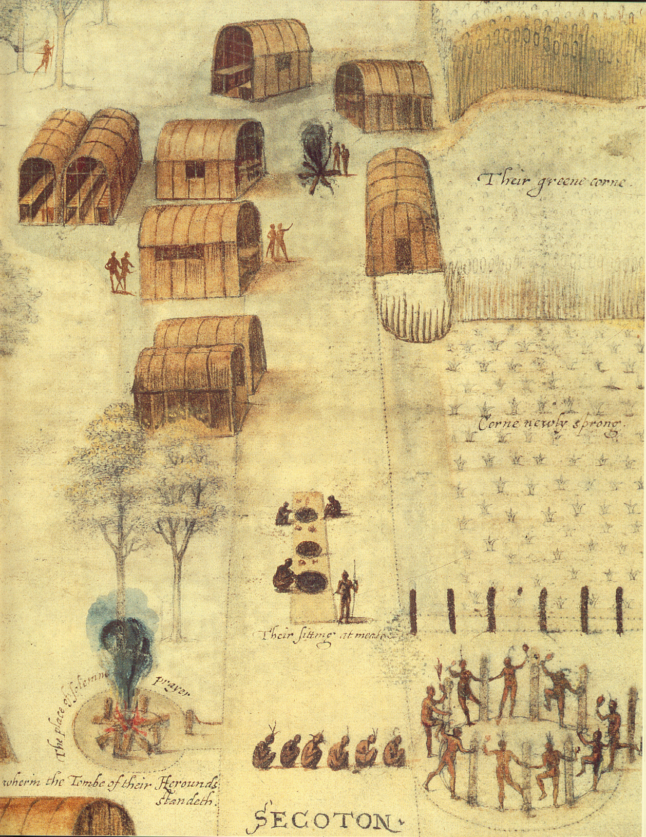
The chiefs, called werowances ("he who is rich"), each controlled up to 18 towns. The greatest were able to muster 700 or 800 fighting men.[citation needed] Chiefs and their families were held in great status and received respect, but they were not all-powerful. To pursue a collective goal, chiefs had to convince their followers that the action would be in the tribe's best interest. The chief was responsible for spreading wealth to his tribe, and, if unable to do so, they received less respect, or even lost respect entirely. [1]

Phillip W. Evans, a linguist, suggested the word Croatan means "council town" or "talk town", which likely indicates the residence of an important leader and a place where councils were held.[2]

The State-recognized Tribes claiming descent from the Croatan people have members who live predominantly in Cumberland, Sampson, and Harnett counties.[3][4]

Beliefs

[edit]

According to Thomas Harriot, the Native Americans living in coastal North Carolina believed there was "one only chief and great God, which has been from all eternity" and which made petty gods "to be used in the creation and government to follow."[5] They believed in the immortality of the soul. Upon death, the soul either enters heaven to live with the gods or goes to a place near the setting sun called Popogusso, to burn for eternity in a huge pit of fire. The concepts of heaven and hell[clarification needed] were impressed upon the common people to encourage them to respect leaders and live a life that would produce rewards in the afterlife.

Conjurors and priests were distinctive spiritual leaders. Priests were chosen for their knowledge and wisdom and were leaders of the organized religion. Conjurors, on the other hand, were chosen for their magical abilities. Conjurors were thought to have powers from a personal connection with a supernatural being (mostly spirits from the animal world).[6]

European colonization

[edit]

It is known that the arrival of English settlers upset some pre-existing tribal relationships. The Algonquian people advocated cooperation, while others (the Yamasee, Cherokee and Chickasaw, for example) resisted this approach. Later, this conflict between tribes and settlers would lead to the Yamasee War. Tribes that maintained mutually beneficial contact with the settlers gained power through their access to and control of European trade goods. While the English may have held great military superiority over the Carolina Algonquians, the Native Americans' control over food and natural resources was a much more decisive factor in the conflict with early settlers. Despite the varying relationships among tribes, the Roanoke and Croatan were believed to have been on good terms with English colonists of the Roanoke Colony. Wanchese, the last leader of the Roanoke, accompanied the English on a trip to England, although he was distrustful of the English.[7] In 1586, Wanchese finally severed his former good relations with the English, leaving Chief Manteo as the colonists' sole native ally.[8]

The Lost Colony

[edit]
Governor John White returned to Roanoke in 1590 to find the word "Croatoan" carved on a palisade.

Some of the survivors of the Lost Colony of Roanoke may have joined the Croatan. Governor White finally reached Roanoke Island on August 18, 1590, three years after he had last seen them there, but he found his colony had been long deserted. The buildings had collapsed and "the houses [were] taken down." The few clues about the colonists' whereabouts included the letters "CROATOAN" carved into a palisade. Croatoan was the name of a nearby island (likely modern-day Hatteras Island) in addition to the local tribe of Native Americans. Roanoke Island was not originally the planned location for the colony and the idea of moving elsewhere had been discussed. Before the Governor's departure, he and the colonists had agreed that a message would be carved into a tree if they had moved and would include an image of a Maltese Cross if the decision was made by force. White found no such cross and was hopeful that his family was still alive.[9]

Speculation of the fate of the "Lost Colony"

[edit]

In 1709, English explorer John Lawson wrote A New Voyage to Carolina, in which he recounts the history of North Carolina. He describes the remains of an English fort on Roanoke Island, and then conjectures that the "Hatteras Indians" were descended from the settlers at Roanoke, stating "A farther Confirmation of this we have from the Hatteras Indians, who either then lived on Ronoak-Island, or much frequented it. These tell us, that several of their Ancestors were white People, and could talk in a Book, as we do; the Truth of which is confirm’d by gray Eyes being found frequently amongst these Indians, and no others."[10]

Based on legend, some Lumbees, based in North Carolina, self-identified as descendants of the Croatan and survivors of the Lost Colony of Roanoke Island. In 1885, historian Hamilton McMillan proposed a connection between the Lumbees and the early English colonists who settled on Roanoke Island in 1587 and the Algonquian tribes who inhabited coastal North Carolina at the same time. McMillan's hypothesis contends that the colonists migrated with the Indians inland. In 1914, when Special Indian Agent O. M. McPherson was reporting on the rights of various Indian groups, he published a list of names of the Lost Colony, claiming names on the list were typical Indian names in the North Carolina counties of Robeson and Sampson, due to them interbreeding with other settlers, claiming many of the surnames included were those of Croatan Indians.[11][3] Historian Karen Blue states that connections between the Lumbee and specific earlier tribes cannot be traced in the historical record, and that many people repeat this theory, often adding more broken evidence.[12][13] Sociolinguist Walt Wolfram suggests that identifying with the prestige of Roanoke settler origin served to elevate their sense of privilege though association with European rather than African lineage, while simultaneously maintaining a Native American claim to identity.[14]

Research

[edit]

Researchers from the University of Bristol, United Kingdom, have also been excavating on Hatteras Island in conjunction with the Croatoan Archaeological Society.[15]

Roberta Estes founded the Lost Colony Center for Science and Research which excavated English artifacts within the territory of the former Croatan tribe. The artifacts may also be evidence of trade with the tribe or of Natives finding them at the former colony site. The center conducted the Lost Colony DNA Project to try to determine if there are European lines among Croatan descendants. However, no bones from the Lost Colony have been found to sequence DNA, and, as of 2019, the project had not identified any living descendants.[16]

Modern claimants

[edit]

Lumbee historian Malinda Maynor Lowery wrote that, in 1890, a group of about 100 people who self-identified as Croatan descendants, or Lumbees, left Robeson County, North Carolina, for southern Georgia. This group considered themselves to be "Indians". They headed back to Bulloch County where they could keep their people together as "Indians". They used the segregation of Jim Crow South to develop themselves as an entire community.[17] Later on, the self-identified Croatans faced both economic hardship and social injustice. As a result, most members of the community returned to North Carolina by 1920.[18] Lowery is "highly skeptical" of the theory of descent from the Lost Colony.[19]

In 1910, the North Carolina state legislature renamed the Croatan Indians in North Carolina to "Cherokee".[20] The North Carolina state legislature recognized the Croatan Indians of Robeson County and the Croatan Indians of Sampson County in 1911.[21] The General Assembly ruled "That said Indians and their descendants shall have separate schools for their children, school committees of their own race and color, and shall be allowed to select teachers of their own choice".[22] Today, these two groups are state-recognized tribes, known as the Lumbee Tribe of North Carolina and the Coharie Intra-tribal Council, Inc., respectively.[4] The Croatan Indian Tribe of South Carolina, an unrecognized organization, claims to descend from Croatan people.[23]

Notable people

[edit]
  • Manteo, ambassador and mediator; disappeared after 1587.

See also

[edit]

Notes

[edit]

References

[edit]
Revisions and contributorsEdit on WikipediaRead on Wikipedia
from Grokipedia
The Croatan were a small Algonquian-speaking Native American tribe inhabiting the barrier islands and coastal mainland of present-day , particularly areas now encompassing parts of Dare and Carteret counties. They subsisted primarily through , , and gathering in the region, maintaining a relatively peaceful existence amid intertribal dynamics. The tribe's chieftain, Manteo, forged an early alliance with English explorers during Sir Walter Raleigh's expeditions in the 1580s, distinguishing the Croatan from more hostile neighboring groups like the . Croatan's historical significance is inextricably linked to the Roanoke colonies, where Manteo served as a guide and intermediary, earning him baptism and the title "Lord thereof" from Queen Elizabeth I in 1587. Following the disappearance of the 1587 Lost Colony—comprising 115 English settlers—the sole explicit clue left behind was the word "CROATOAN" carved into a palisade post and the letters "CRO" on a nearby tree, suggesting relocation to Croatoan Island (modern-day Hatteras Island) or integration with the tribe, as per prior instructions from colony governor John White. This artifact, documented in White's firsthand account, has fueled enduring speculation about assimilation, though archaeological evidence remains inconclusive, with limited English artifacts found in associated sites pointing to possible cultural blending rather than mass survival. Recent analyses of historical maps challenge assumptions about the tribe's precise location, proposing inland or alternative coastal settlements over Hatteras exclusivity. The Croatan's legacy persists in debates over the Lost Colony's fate, influencing theories of genetic and cultural continuity among later groups like the , though direct empirical linkages lack definitive proof beyond circumstantial oral traditions and sparse material finds. Their alliance with the English highlights early patterns of Native-European interaction driven by mutual strategic interests, contrasting with broader conflicts, yet underscoring the fragility of such pacts amid supply failures and environmental pressures.

Etymology and Geography

Origins of the Name

The name Croatan, frequently spelled Croatoan in 16th-century English documents to reflect phonetic approximations of indigenous pronunciation, derives from the Algonquian language spoken by Native American tribes along the coast. It served as both a toponym for an island south of Roanoke—now associated with parts of modern —and an for the resident tribe, whose members included Manteo, a key ally to the English explorers who was captured during the 1584 voyage and later returned as a cultural intermediary. The term's initial recording in European sources occurred during the 1585 expedition under Sir , appearing on maps by John White that labeled "Croatoan" as a distinct coastal feature and settlement area, distinct from the Roanoke (Hatorask) locality. Linguistic analysis of Carolina Algonquian, an extinct Eastern Algonquian dialect, posits that "Croatoan" combines roots such as cro or cra- (related to speaking or council) with -tan (denoting a town or enclosed settlement), yielding interpretations like "talk town" or "council town"—a designation fitting for a locale serving as a hub for tribal deliberations or alliances. This etymology, while not directly attested in surviving vocabularies compiled by Thomas Harriot during the period, aligns with reconstructed patterns from related Algonquian languages and the site's documented role in intertribal interactions, as evidenced by Manteo's facilitation of English-native diplomacy. No alternative derivations, such as non-indigenous origins, find support in primary historical records or archaeological context.

Croatan Sound and Associated Locations

Croatan Sound is a coastal waterway in Dare County, North Carolina, situated between Roanoke Island to the east and the North Carolina mainland to the west. Approximately 10 miles long and varying in width from 2 to 5 miles, it forms part of the Intracoastal Waterway and links Albemarle Sound to the north with Pamlico Sound to the south, facilitating tidal exchange and supporting estuarine ecosystems with depths typically ranging from 15 to 20 feet without requiring dredging. The sound's name derives from the Croatan tribe, an Algonquian-speaking group whose territory encompassed adjacent coastal areas during the late 16th century. Key associated locations include , immediately east of the sound, where English explorers established temporary settlements in the 1580s, and the mainland ports such as Manns Harbor, connected via U.S. Highway 64/264 bridge spanning the sound near . To the south, across , lies , historically termed Croatoan Island in colonial records and traditionally linked to the Croatan tribe's primary village site based on John White's 1587 accounts of their residence there. However, recent analyses of 16th- and 17th-century maps by the First Colony Foundation indicate that Croatan tribal lands more likely centered around the Croatan Sound vicinity, , and parts of the Alligator River watershed, with no Croatan presence on after the early 1500s; instead, the Coree tribe occupied that area, challenging the long-held equation of Croatoan Island solely with Hatteras. This reinterpretation aligns with cartographic evidence showing "Croatan" labels near the sound rather than Hatteras, suggesting tribal migrations and name shifts influenced European mappings. The sound's hydrological role, influenced by tidal flows from both Albemarle and systems, creates brackish conditions supporting diverse habitats like salt marshes and shellfish beds, which sustained indigenous populations pre-colonially and continue to define the region's . Nearby Roanoke Sound, to the east of , parallels Croatan Sound and connects to the Atlantic via , forming a barrier island-lagoon complex that shaped early challenges for European vessels. These interconnected waterways, monitored for at sites like the U.S. 64/264 bridge (35.837°N, 75.697°W), remain integral to understanding 16th-century coastal dynamics amid the Lost Colony narrative.

Pre-Colonial Indigenous Context

Regional Tribes and Croatoan People

The coastal regions of present-day North Carolina, encompassing Roanoke Island, Croatan Sound, and adjacent areas, were home to several Algonquian-speaking indigenous groups prior to European contact in the late 16th century. These included the Secotan, who dominated the mainland north of Albemarle Sound with villages such as Secotan and Pamauik, exerting influence over nearby communities; the Roanoke tribe on Roanoke Island itself; and the Dasamonquepeuc further inland along river systems. Archaeological evidence and early accounts indicate these tribes maintained semi-autonomous villages, engaged in maize agriculture, fishing, and seasonal hunting, with populations likely numbering in the hundreds per group based on village sizes documented by explorers. Among these, the Croatoan people occupied Croatoan Island—now —and possibly Ocracoke Island, forming a distinct Carolina Algonquian tribe known for their maritime adaptation to environments. Their territory featured sandy soils supporting limited supplemented by abundant resources, including fish, , and waterfowl, which sustained small, dispersed settlements. Historical records from English expeditions identify Manteo, a Croatoan native whose mother led the tribe, as a key figure, highlighting their relatively amicable initial relations with Europeans compared to more hostile mainland groups like the under . Ethnographic sketches by John White depict Croatoan villages with thatched longhouses arranged in palisaded enclosures, reflecting defensive structures amid inter-tribal tensions. The Croatoan maintained alliances with island and coastal neighbors, potentially as part of a loose Secotan-influenced network, though they operated independently with their own leadership and customs. Linguistic and material cultural similarities—such as Algonquian dialects, shell-tempered pottery, and copper artifacts from trade—linked them to broader regional patterns, yet their island isolation fostered unique resilience against mainland epidemics and conflicts. By the 1580s, estimates suggest the Croatoan numbered around 500-700 individuals, inferred from expedition reports of village scales, though direct censuses are absent. Post-contact pressures, including disease and displacement, contributed to their eventual dispersal and integration with other groups, but pre-colonial records emphasize their role as intermediaries in the Albemarle-Carolina sound ecosystem.

Societal Structure and Environment

The Croatoan inhabited coastal barrier islands and adjacent mainland areas along the of present-day , including and regions near Croatan Sound. This environment encompassed protected sounds, marshes, and forests, fostering a diverse ecosystem rich in such as and , alongside terrestrial resources like deer and wildfowl, which supported subsistence through seasonal , , and gathering. Barrier islands mitigated storm impacts while enabling access to both Atlantic and estuarine habitats. Supplementing foraging, the Croatoan practiced , cultivating , beans, and cucurbits in fertile coastal soils, with fields cleared via controlled burning and tended by communal labor. Housing typically consisted of mat-covered longhouses or wigwams arranged in small villages, accommodating extended kin groups and facilitating social cohesion amid a prone to hurricanes. Societal organization followed Algonquian patterns, centered on autonomous villages governed by a werowance—a chief whose stemmed from accumulation, demonstrated prowess, and hereditary claims, with "werowance" denoting "he who is rich." Influence expanded through tribute from subordinate and alliances, as seen in the of Manteo's over the Croatoan . formed the basis of social units, with common and clans regulating marriage and inheritance. Village councils, comprising elders and priests, advised the werowance on decisions, integrating spiritual authority where shamans interpreted omens and conducted rituals tied to environmental cycles. Economic roles divided by gender, with men hunting and fishing, women farming and processing food, reflected adaptive strategies to the coastal niche. Population estimates for individual villages ranged from dozens to low hundreds, enabling flexible responses to resource variability.

Early European Encounters

Initial Expeditions (1580s)

The inaugural English reconnaissance to the coastal region of present-day , encompassing areas near Croatan Island, commenced in 1584 under captains Philip Amadas and Arthur Barlowe, dispatched by Sir Walter Raleigh on April 27 aboard two vessels. Arriving at Ocracoke Inlet by late June and proceeding northward along the , the explorers anchored initially near Hatteras (Hatorask), adjacent to Croatan territory, before sailing to approximately 15 miles north. There, they encountered Algonquian-speaking indigenous groups, including Secotans under chief (later Pemisapan), whose brother Granganimeo extended hospitality and supplied the English with provisions; Granganimeo also provided Manteo, a youth from the allied Croatoan tribe on the southern island, as an interpreter, facilitating initial communication and marking the first documented English contact with Croatoan individuals. Barlowe's subsequent narrative praised the region's abundant natural resources—such as fertile soils yielding corn, beans, and —and the ostensibly amicable native demeanor, though these accounts reflected exploratory optimism rather than sustained empirical verification. The expedition departed in October 1584, returning to with Manteo and Wanchese (a Roanoke native), whose presence later informed Raleigh's colonial ambitions. A subsequent military-oriented venture in 1585, led by Raleigh's cousin and numbering 107 men under governor , reinforced the Roanoke outpost after arriving in late June via seven ships. Manteo, returned from , served as a key intermediary, aiding Lane's inland expeditions to prospects and mainland villages like Aquascogoc, where English forces seized corn amid emerging tensions with leaders. Croatoan inhabitants, under Manteo's kin, maintained relatively cooperative ties, contrasting with deteriorating relations elsewhere; Lane's records note Croatoans as potential allies for relocation, though Pemisapan's feigned assistance—promising guides to Croatoan after dispersing his "visitors" (likely warriors)—highlighted indigenous strategic caution amid provisioning strains on the English. Escalating hostilities culminated in a May 1586 preemptive English assault on Dasemunkepeuc, Pemisapan's capital, where Lane's men killed the chief and allies; a prior nocturnal raid had erroneously slain Croatoan men mistaken for , underscoring navigational errors and fragilities in the fog-shrouded terrain. Supply shortages and Sir Francis Drake's June 1586 arrival prompted evacuation, with Lane's colony abandoning Roanoke by late summer, though Grenville left 15-18 men behind, possibly influencing later Croatoan associations. These expeditions yielded maps and reports emphasizing 's strategic proximity and native interoperability, yet revealed causal vulnerabilities in English dependency on indigenous goodwill and local ecology.

Alliances and Conflicts with Colonists

The English first encountered the Croatan people during the 1584 reconnaissance expedition commanded by Philip Amadas and Arthur Barlowe, establishing cordial relations through trade and hospitality on the , which led to Manteo—a young man affiliated with the Croatan weroansqua (female chief)—and Wanchese traveling to as cultural intermediaries. Manteo, originating from Croatoan territory, demonstrated consistent allegiance to the English, assisting with navigation, translation, and advocacy upon his return, while Wanchese, from the Roanoke tribe, grew increasingly antagonistic toward the newcomers. These early interactions laid the foundation for selective alliances, with the Croatans providing intelligence on regional tribes and resources, contrasting with broader Algonquian suspicions fueled by European demands for food and metal tools. Under Ralph Lane's governance of the 1585 military colony comprising 108 men on , Manteo continued to support English efforts by guiding exploratory parties inland during winter 1585–1586 and adopting European attire as a symbol of alignment. Direct conflicts with the Croatans remained absent, as Lane's aggressions targeted mainland groups like the Secotans—such as the July 1585 burning of Aquascogoc village over a stolen silver cup and the June 1, 1586, decapitation of Chief Pemisapan () amid famine-induced thefts—leaving the island-based Croatans relatively insulated due to Manteo's . These hostilities stemmed from English perceptions of native duplicity and resource scarcity, exacerbating regional animosities without extending to Croatan villages, which supplied limited aid amid the colony's abandonment in June 1586 following Sir Francis Drake's arrival. John White's 1587 civilian expedition of 118 settlers reinforced the Croatan alliance through Manteo's presence, who advocated for relocation southward and participated in retaliatory actions against persistent native raids. On July 31, 1587, Croatan informants alerted White to attacks by Roanoke and mainland warriors that killed one English assailant and wounded ten others, prompting defensive measures. An English assault on the hostile Dasemunkepeuc village on , 1587, guided by Manteo, inadvertently killed Croatan noncombatants mistaken in the fray, introducing friction despite Manteo's subsequent baptism and ennoblement as "Lord thereof" of Roanoke and Dasemunkepeuc on August 13, 1587. This episode highlighted the precariousness of alliances, where tribal affiliations blurred amid combat, yet the Croatans' overall cooperation—rooted in Manteo's kinship ties and mutual interests against common foes—persisted as a counterweight to widespread Algonquian resistance.

The Roanoke Lost Colony Connection

Establishment of the 1587 Colony

In January 1587, Sir Walter Raleigh incorporated the "Cittie of " as a chartered entity for permanent settlement, appointing artist and explorer John White as governor to lead a civilian expedition including families, unlike the prior military venture. The group, comprising approximately 118 men, women, and children—such as White's daughter and son-in-law —departed England in late April 1587 aboard three ships, with the intent to establish the colony along the for better agricultural prospects and distance from prior hostilities. Accompanying them was Manteo, a chieftain of the Croatoan tribe from nearby , who had previously aided English explorers and served as translator, fostering an alliance that positioned the Croatoans as key local partners against antagonistic tribes like the Roanokes. The voyage encountered delays from storms and provisioning stops, but pilot Simon Fernandes, master of the flagship Lion, unilaterally decided to anchor off on July 22, 1587, citing the need to resupply and check on the 15-man garrison left by in 1586, rather than proceeding to the Chesapeake as planned. Upon landing, White's party discovered the garrison's site abandoned, with only bleached bones and a severed hand indicating likely violent dispersal by indigenous forces, prompting Fernandes to refuse further transport and depart for , stranding the settlers at Roanoke despite White's protests. The colonists, now isolated on bordering Croatan Sound—a shallow separating it from Croatan lands—repaired Lane's dilapidated fort and houses, planted crops including barley and pease, and relied on Manteo for intelligence on regional threats and resources. Initial establishment efforts emphasized family-oriented permanence, marked by the baptism of Manteo on August 13, 1587, aboard the departing supply ship Lion, where Queen Elizabeth's name was invoked to confer upon him the title "Lord thereof" for the Roanoke territory, symbolically extending English sovereignty with Croatoan endorsement. Five days later, on August 18, Eleanor Dare gave birth to Virginia Dare, the first child of English parentage born in the Americas, underscoring the colony's demographic shift toward sustainability. Facing shortages of tools, arms, and provisions exacerbated by the unplanned location, the settlers urged White to return to England for relief on August 25, 1587; he sailed two days later aboard the Lion, leaving 117 behind under Dare's interim command, with instructions to signal relocation by carving a destination on a tree or post if abandoning Roanoke—explicitly referencing Croatoan as a potential refuge given its allied status and proximity.

The "CROATOAN" Clue and Departure

John White, governor of the Roanoke colony, departed for England on August 27, 1587, to secure supplies and reinforcements for the 115 settlers, including his daughter Eleanor Dare and granddaughter Virginia Dare, the first English child born in the New World. Delays caused by the Anglo-Spanish War, including the 1588 Spanish Armada invasion, prevented his return until August 18, 1590, aboard ships under Simon Fernandes. Upon landing at Roanoke Island, White found the site abandoned, with the houses dismantled in an orderly manner and the palisade fort partially taken down, suggesting a deliberate relocation rather than hasty flight or violence. No graves, skeletons, or signs of battle were observed, and colonists' personal items like armor and tools remained undisturbed except for damage from exposure. The sole explicit indicator of the settlers' fate was the word "CROATOAN" carved into a tall post of the fort's entrance and the letters "CRO" etched into a nearby tree trunk, without the agreed-upon symbol denoting distress or capture by hostile forces. Prior instructions from White had directed the colonists, if relocating due to hardship, to leave signage of their destination—specifically naming Croatoan Island (modern ) as a fallback site allied with Chief Manteo of the Croatoan tribe, who had been baptized and granted lordship over Roanoke by the settlers. This carving implied a voluntary move to join or seek aid from the Croatoans, consistent with earlier reports of strained relations with mainland tribes like the Secotans but amity with the islanders. White's party planned to sail to Croatoan to search but was thwarted by a severe storm on , 1590, which damaged vessels and forced departure for without further . The colonists' departure from Roanoke likely occurred between late 1587 and 1589, driven by acute supply shortages—exacerbated by Fernandes's earlier diversion of provisions—and seasonal challenges, as evidenced by the structured disassembly of structures and absence of distress markers. No contemporary accounts contradict this interpretation of planned migration over or starvation in place, though the exact timing and route remain unverified absent direct records from the settlers.

Assimilation Hypothesis and Empirical Evidence

The assimilation hypothesis posits that the 1587 Roanoke colonists, facing resource shortages and hostile relations with mainland tribes, relocated southward to Croatoan Island—modern —and integrated with the local Croatoan people through intermarriage, of indigenous survival practices, and cultural blending, rather than perishing en masse or dispersing northward. This theory aligns with Governor John White's 1590 discovery of the word "CROATOAN" carved on a palisade post without the agreed-upon distress of a , suggesting a planned move to the allied Croatoan territory under Chief Manteo, who had accompanied the colonists and received the title of thereof. Proponents argue this integration explains the absence of skeletal remains or signs of violence at Roanoke, as the group of approximately 115 settlers— including women and children—would have sought alliance with friendly Algonquian-speakers amid deteriorating conditions. Archaeological evidence supporting assimilation centers on Hatteras Island excavations, where European metalworking debris has been found in contexts indicative of prolonged cohabitation rather than mere trade. In 2024–2025 digs at sites linked to Croatoan villages, archaeologists uncovered large deposits of hammer scale—iron oxide flakes byproduct of blacksmithing—consistent with 16th-century English forging techniques, alongside Native American pottery and longhouse features, suggesting colonists contributed specialized skills like iron processing to sustain the community. A European copper ring and sword handle fragments intermixed with Algonquian ceramics in refuse middens further imply domestic integration, as such items exceed typical sporadic exchange volumes observed elsewhere. Elizabethan-era artifacts, including glass beads and metal tools, recovered from Croatoan sites on Hatteras since the 1990s, align temporally with the colony's disappearance around 1588–1590, though quantities remain modest and do not include structural remains of an English fort. Historical accounts provide circumstantial corroboration, with Jamestown explorer John Smith reporting in 1608 that Hatteras-area Natives described "manned howses" built with English tools and sightings of "five of their own nation" with fair skin and European attire among the Croatoans, interpreted by some as assimilated descendants. Earlier, in 1602, Jamestown settlers noted gray-eyed individuals with partial English garb on the , potentially referencing hybrid offspring. However, these reports are secondhand and unverified, derived from Native oral traditions filtered through English intermediaries, and lack direct confirmation from primary Roanoke records. Critics contend the evidence is inconclusive, as artifacts could result from pre-1587 trade or post-1600 scavenging, with no definitive DNA linkages or written colonist testimonies recovered to prove full assimilation over dispersal or annihilation. Ongoing research, including potential genomic analysis of Hatteras descendants, has yet to yield population-level markers of English ancestry amid predominant Algonquian heritage, underscoring that while integration remains the most parsimonious explanation given the "CROATOAN" directive and absence of catastrophe indicators, empirical substantiation falls short of certainty.

Post-Contact Evolution and Assimilation

17th-18th Century Dispersal and Integration

During the 17th century, the Croatan people's coastal territories underwent documented shifts, with maps indicating relocation from to mainland areas east of the Alligator River by 1671, as shown in the First Lords Proprietors . Subsequent surveys, such as the Maule survey of 1684 and map circa 1733, restricted Croatan presence to regions northwest of near modern Mashoes, reflecting gradual inland dispersal amid encroaching European settlement and intertribal dynamics. Archaeological middens from the period reveal sustained communities utilizing European iron tools and beads, suggesting adaptive rather than wholesale displacement. European contact exacerbated population declines through introduced diseases, reducing coastal Algonquian groups like the Croatan from pre-contact estimates exceeding 1,000 individuals to fragmented remnants by the early 1700s, though specific Croatan census data remains absent from colonial records. Intermarriage with English settlers contributed to this dispersal, as evidenced by explorer John Lawson's 1701 account of Hatteras descendants—successors to the Croatan—possessing "white ancestors" capable of reading English books. Similarly, Rev. John Irmstone's 1710 report described Hatteras inhabitants as "half Indian and half English," indicating widespread admixture that blurred tribal boundaries and facilitated cultural hybridization. By the mid-18th century, the distinct faded on the , supplanted by the Hatteras designation on and partial absorption by neighboring Coree groups, driven by marital alliances with other eastern Carolina . This integration preserved elements of Croatan , such as European-influenced artifacts in native sites, but eroded autonomous tribal structures amid colonial expansion and the absence of formal reservations for coastal remnants. Historical maps from 1775 onward omit explicit Croatan territories, underscoring a transition to dispersed, mixed communities rather than organized polities.

19th Century Reemergence as "Croatan Indians"

In the aftermath of the Civil War, mixed-ancestry communities in Robeson, Sampson, and adjacent counties of , previously enumerated as "free persons of color" or mulattoes in censuses, increasingly asserted a distinct Native American heritage to secure separate educational and social status amid intensifying . These groups, numbering around 2,500 in Robeson County by the late and owning approximately 60,000 acres along the , drew on oral traditions of descent from coastal tribes and early English settlers, rejecting classification with freed and refusing attendance at designated negro schools, which contributed to high adult illiteracy rates. Prior to state laws restricting their franchise and access, some had voted as freemen and enrolled children in white schools, but post-1835 exclusion fostered isolation and reliance on private subscription schools. Physician and state legislator Hamilton McMillan emerged as a central proponent of the "Croatan" designation in the , investigating local lore that positioned these communities as amalgamations of the historical Croatan Algonquians—associated with —and survivors of the 1587 Lost Colony, evidenced by shared surnames (e.g., Berry, Cooper, Dare) between colonists and local families, English proficiency, and lighter complexions noted in earlier accounts like John Lawson's 1709 observations of Hatteras-area Indians with gray eyes. McMillan's analysis, disseminated in his 1888 pamphlet Sir Walter Raleigh's Lost Colony, identified 41 surname matches and posited inland migration by the mid-17th century, aligning with settler reports from 1715 of English-speaking groups tilling soil along the . This narrative, rooted in circumstantial historical parallels rather than direct records, reframed longstanding family traditions—such as those among the Brewingtons, who traced maternal lines to Cherokee individuals acquiring land in 1807—as evidence of a preserved Croatan lineage. Community petitions formalized this identity push, including an 1887 request to federal authorities for aid supporting 1,165 school-age children based on Lost Colony descent claims, followed by a 54-signature to in 1888 seeking educational funding explicitly as Croatan Indians, which drew initial inquiry from the U.S. Indian Office but no tribal rights or appropriations due to lack of prior federal recognition. These efforts highlighted tensions between asserted coastal origins and the groups' inland Siouan-influenced heritage, as well as strategic motivations for separation in a of binary racial categorization, though McMillan's work attributed the identity revival to authentic traditions of and intermarriage avoidance with negroes.

Modern Recognition and Identity Debates

State Recognition in North Carolina (1885)

In 1885, amid the enforcement of laws in , the General Assembly responded to petitions from residents of Robeson County identifying as Indians by enacting legislation that formally acknowledged their distinct ethnic status. On February 10, 1885, Chapter 51 of the session laws, titled "An Act to Provide for Separate Schools for Croatan Indians in Robeson County," designated these individuals as "Croatan Indians" and authorized the establishment of separate public schools for them, excluding them from white and black educational systems. The act specified that the Croatan Indians resided primarily in Robeson County and directed county commissioners to appoint trustees for their schools, funded through a and property assessments levied exclusively on the group. This recognition stemmed from community leaders' claims of descent from the 1587 Roanoke colonists, who reportedly integrated with the Croatan tribe after leaving the "CROATOAN" inscription, a narrative that influenced the naming and served to differentiate them from African American and European American populations during the Jim Crow era. The legislation marked the first state-level acknowledgment of the group as Indians, enabling access to segregated but dedicated public resources and setting a for subsequent expansions, such as funding for additional facilities in 1889. However, it did not confer broader legal rights or federal status, and enforcement relied on local officials, reflecting the era's approach to non-binary racial classifications in the .

Transition to Lumbee Designation and Federal Efforts

In the early , the group originally designated as Croatan Indians by in 1885 shifted names multiple times amid debates over origins, adopting "Cherokee Indians of Robeson County" in 1911 and briefly "Siouan Indians" in 1913 before reverting to "Indians of Robeson County." By the 1950s, leaders sought a name tied to local geography rather than contested historical theories, leading to a 1952 community referendum under D.F. Lowrie's guidance that approved "," referencing the (later Lumbee) River in Robeson County. The formalized this change in 1953, designating them the Lumbee Indians and establishing the Lumbee Indian Fair to celebrate the transition. Federally, the Lumbee Act of 1956 (Public Law 84-570), signed by President on June 7, 1956, acknowledged the as an with historical presence in Robeson and surrounding counties but explicitly barred them from federal services available to recognized tribes and exempted them from the ' acknowledgment process. This partial recognition stemmed from congressional compromise amid Cold War-era concerns over tribal claims and avoided granting benefits like those under the , despite earlier petitions linking them to or other groups. Since 1956, the Tribe has pursued full federal recognition through legislative bills, including repeated introductions of the Lumbee Recognition Act and the Lumbee Fairness Act, aiming to amend the 1956 law and provide tribal status, eligibility, and services. Efforts intensified in the 21st century, with passage of recognition bills in 2009 and 2018 stalled by opposition citing insufficient evidence of continuous tribal existence under a single name and doubts over distinct indigenous ancestry versus mixed European, African, and Native heritage. As of 2025, no full recognition has been achieved, leaving the reliant on state services and partial federal acknowledgments for veterans and social programs.

Controversies Over Ancestry and Legitimacy

The Lumbee Tribe, formerly known as the , has claimed descent from the historical Croatoan people of the and possibly intermingled survivors of the 1587 Roanoke Lost Colony, a popularized in the late by figures like Hamilton McMillan to assert indigenous continuity. However, historical analyses indicate that these groups coalesced in the 18th and 19th centuries from diverse remnants of Siouan-speaking tribes such as the and Keyauwee, alongside and possibly escaped African slaves, forming what anthropologists term a "triracial isolate"—a mixed-heritage community with Indian, white, and black ancestries. This origin lacks documentation of unbroken tribal governance or distinct cultural practices tied to the Croatoan, with identity as "Indians" emerging primarily as a during Jim Crow-era segregation to avoid classification as "colored" and secure separate schools and . Anthropological assessments have fueled debates over their racial composition. In a 1973 serological study using blood group markers, physical anthropologist William Pollitzer concluded that the Lumbee exhibited more European ("white") and African ("Negro") ancestry than Native American, challenging petitions for federal recognition by undermining claims of predominant indigenous lineage. Such findings aligned with earlier observations of tri-racial admixture in Robeson County populations, where physical traits and historical intermarriages suggested dilution of any original Native elements through and isolation. Critics, including other federally recognized tribes, argue this positions the Lumbee not as a continuous Native entity but as a socio-racial construct, with speculative ties to Roanoke serving more as than verifiable . Genetic research reinforces skepticism regarding substantial Native ancestry. Commercial and forensic DNA databases, including Y-chromosome, mitochondrial, and autosomal analyses from Lumbee-identified samples, show haplogroups predominantly of European and African origin, with Native American markers appearing in fewer than 5% of lineages on average. A study of 106 Lumbee individuals using STR loci found no dominant indigenous genetic signature, consistent with triracial models where initial Native admixture was minimal and subsequently overwhelmed by other inputs. These results contrast with tribal assertions of Croatoan heritage, as peer-reviewed serological data and limited genomic surveys indicate that modern Lumbee genetics align more closely with mixed Southeastern U.S. populations than with Algonquian or Siouan tribal baselines. These ancestry disputes underpin ongoing legitimacy challenges, particularly in federal recognition efforts. The denied the petition in 1994, citing insufficient evidence of political continuity from a historical and reliance on 19th-century self-identification rather than treaty-based or blood quantum criteria. Proponents of recognition emphasize cultural persistence and state acknowledgment since 1885, yet opponents highlight the absence of reservations, distinct language, or artifacts linking to pre-colonial Croatoan society, viewing the group as a tri-racial community that adopted "Indian" identity for socioeconomic advantages amid racial binaries. Legislative pushes for recognition via , bypassing administrative criteria, have persisted into 2025 but face resistance from tribes like the , who prioritize empirical tribal sovereignty over ethnic self-identification.

Cultural and Genetic Legacy

Traditional Beliefs and Practices

The Croatan Indians of the late , primarily residing in Robeson and adjacent counties in , predominantly practiced Baptist Christianity, establishing separate congregations to maintain communal religious autonomy amid . In 1881, they formed the Burnt Swamp Baptist Association to serve their communities, initially as an independent body before seeking affiliation with broader Baptist conventions, reflecting a commitment to evangelical over any preserved indigenous spirituality. By 1885, the association adopted the name Burnt Swamp Indian Association of the Croatan Indians, underscoring their self-identified ethnic distinction while centering worship around Bible-based sermons, revivals, and moral instruction delivered by Indian ministers such as Rev. M. L. Brewington. These practices emphasized personal piety, community support, and separation from white and Black churches, with no documented continuity of pre-colonial rituals amid their historical assimilation into English-speaking, agrarian lifestyles. While the Croatan Indians invoked descent from the historical Croatoan tribe—an Algonquian-speaking group encountered by English explorers in the 1580s—their religious observances showed no empirical traces of ancestral or , likely extinguished through intermarriage, displacement, and missionary influence by the 18th century. The original Croatoan, as part of Carolina Algonquian peoples, adhered to a cosmology featuring a supreme eternal deity who delegated creation to lesser gods and spirits known as montoac, with priests interpreting omens and conducting ceremonies to appease these entities for bountiful harvests or protection. Beliefs included soul immortality and an determined by earthly conduct, but such systems dissolved among survivor descendants by the colonial era, supplanted by without hybrid forms evident in Croatan records. Isolated cultural echoes, such as skilled traditional dances performed by individuals like Nathan Brewington in the , appeared sporadically but lacked religious context or communal revival. Every claim requires citation; the absence of verifiable indigenous practices in primary accounts highlights assimilation's causal role, as intergroup unions and economic pressures eroded distinct spiritual traditions by the time of formal Croatan recognition in 1885. Their legacy thus manifests in devout Baptist institutionalism, including church-led education and mutual aid, rather than esoteric rites.

Archaeological and DNA Research Findings

Archaeological investigations on , historically associated with the Croatoan people, have yielded artifacts indicative of late 16th-century European-Native interaction. Excavations by the First Colony Foundation since 2009 at sites like the Elizabethan Gardens have recovered Algonquian-style pottery shards, charcoal from hearths dated to the 1580s via radiocarbon analysis, and European-origin items such as a smelted lump and a ring, suggesting technological exchange or cohabitation rather than isolated Native activity. A 2025 dig uncovered a refuse pit containing mixed refuse, including European glass beads alongside Croatoan ceramics, interpreted by lead Mark Horton as evidence of colonists assimilating into local society, though skeptics note the absence of definitive English skeletal remains or structures. Further support comes from sites, where 16th-century copper ore processing debris points to European metallurgical influence on Native groups, potentially extending to Croatoan networks via trade or relocation. No archaeological traces of the colonists appear in the region, aligning with historical accounts favoring a southern move to Croatoan territory over northern migration theories. DNA research on potential Croatan descendants, now largely identified as , remains inconclusive for direct Lost Colony linkage. The Lost Colony DNA Project, analyzing Y-chromosome markers from families with 1580s-era surnames (e.g., Cooper, Yates), has identified haplogroups like R-M269 common in but lacking unique matches to verified colonist lineages, with autosomal tests showing Lumbee admixture of approximately 55% European ancestry post-1600 rather than specifically Elizabethan English. Independent genetic surveys, including those by DNA Consultants, detect elevated Sephardic Jewish or Croatian signals in some Lumbee samples, but these are attributed to later colonial inflows and contested as non-peer-reviewed, with mainstream analyses emphasizing Siouan and Algonquian Native roots over Roanoke integration. No from confirmed Croatoan burials has been sequenced to test assimilation hypotheses, limiting claims to circumstantial genealogy.

Notable Individuals and Contributions

Manteo, a chief of the tribe in the late , allied with English explorers during the Roanoke expeditions, providing guidance and support to Lane's 1585–1586 colony and assisting John White's settlers in 1587. On August 13, 1587, Manteo was baptized by the English and honored as "Lord thereof" of , marking one of the earliest instances of formal recognition of a Native American leader by European colonizers. In the 19th century, among the mixed-ancestry group in Robeson and Sampson Counties who adopted the Croatan designation, Henry Berry Lowery emerged as a prominent figure leading the Lowry Gang from approximately 1866 to 1872. Lowery, born around 1845 to a family of Tuscarora, Lumbee, and Scottish descent, organized resistance against post-Civil War disenfranchisement and violence targeting the local Indian community, including the 1865 execution of his father and brother for possessing firearms. His actions, involving targeted killings of officials and property seizures, positioned him as a folk hero among the Croatan Indians despite official condemnation as an outlaw, with Lowery vanishing into the swamps around 1872. The Lowery family, including early land grantees Henry Berry and James Lowrie in 1732, remained influential leaders among the Croatan descendants in Robeson County, contributing to community organization and land stewardship amid settler encroachments. In Sampson County, prominent Croatan individuals such as those from the Bledsoe family, noted for their community standing, advocated for racial separation and educational opportunities, as detailed in contemporary accounts of Indian families. Enoch Emanuel and C.D. Brewington, Croatan residents of Sampson County, documented sketches of key Indian families in the early , preserving local history and supporting claims for separate schools amid debates over their racial status. These efforts highlighted contributions to and cultural documentation during the push for state recognition in and beyond.

References

Add your contribution
Related Hubs
User Avatar
No comments yet.