

Community hub
Recent from talks
Contribute something
Nothing was collected or created yet.
Transfăgărășan
View on Wikipedia | |
|---|---|
| Drumul Național 7C | |
| Transfăgărășan Transzfogarasi út | |
 | |
 | |
| Route information | |
| Maintained by Compania Națională de Autostrăzi și Drumuri Naționale din România | |
| Length | 151 km (94 mi) |
| Existed | 1974[1]–present |
| Major junctions | |
| From | Pitești |
| To | Arpașu de Jos |
| Location | |
| Country | Romania |
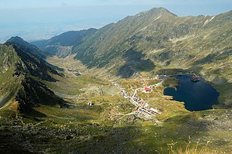
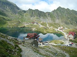
| Major cities | Căpățâneni, Bâlea Lake, Arpașu de Jos, Arefu, Pitești, Curtea de Argeș |
| Highway system | |
The Transfăgărășan (trans + Făgăraș; Hungarian: Transzfogarasi út) or DN7C is a paved mountain road crossing the southern section of the Carpathian Mountains of Romania. It has national-road ranking and is the second-highest paved road in the country after the Transalpina. It starts near the village of Bascov, near Pitești, and stretches 90 kilometres (56 mi) to the crossroad between the DN1 and Sibiu, between the highest peaks in the country, Moldoveanu and Negoiu. The road, built in the early 1970s as a strategic military route, connects the historic regions of Transylvania and Wallachia.[1]
History
[edit]The Transfăgărășan was constructed between 1970 and 1974 during the rule of Nicolae Ceaușescu as a response to the 1968 invasion of Czechoslovakia by the Soviet Union.[2] Ceaușescu wanted to ensure quick military access across the mountains in case of a Soviet invasion. At the time, Romania already had several strategic mountain passes through the Southern Carpathians, whether inherited from the pre-communist era (the DN1 and the high-pass DN67C) or built during the initial years of the Communist regime (the DN66). These passes, however, were mainly through river valleys, and would be easy for the Soviets to block and attack. Ceaușescu therefore ordered the construction of a road across the Făgăraș Mountains, which divide northwestern and southern Romania.[1][2]
Built mainly by military forces, the road had a high financial and human cost. Work was carried out in an alpine climate, at an elevation of 2,000 metres (6,600 ft), using roughly six million kilograms (5,900 long tons; 6,600 short tons) of dynamite, and employing junior military personnel who were untrained in blasting techniques. Many workers died; official records state that only 40 soldiers lost their lives, but unofficial estimates by workers put the number in the hundreds.[2]
The road was officially opened on 20 September 1974, although work, particularly paving of the roadbed, continued until 1980.[1]
Route
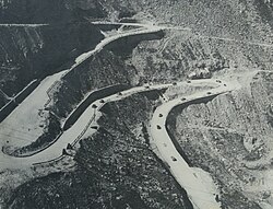
[edit]The road climbs to an altitude of 2,042 metres (6,699 ft), making it the second highest mountain pass in Romania after the Transalpina. It is a winding road, dotted with steep hairpin turns, long S-curves, and sharp descents. It is both an attraction and a challenge for hikers, cyclists, drivers and motorcycle enthusiasts.[3] Due to the topography, the average speed is around 40 km/h (25 mph). The road also provides access to Bâlea Lake and Bâlea Waterfall.
The road is usually closed from late October until late June because of snow. Depending on the weather, it may remain open until as late as November, or may close even in the summer; signs at the town of Curtea de Argeș and the village of Cârțișoara provide information.
The Transfăgărășan has more tunnels (a total of 5)[4] and viaducts than any other road in Romania. Near the highest point, at Bâlea Lake, the road passes through Bâlea Tunnel, the longest road tunnel in Romania at 884 m (2,900 ft).
Along the southern section of the road, near the village of Arefu, is Poenari Castle. The castle was the residence of Vlad Tepes, also known as Vlad the Impaler, who is said to have been the inspiration for Bram Stoker's Count Dracula. However, Bram Stoker never stated that Tepes was the inspiration for Dracula and Stoker himself never visited Romania. The castle that Stoker used in his novel for illustration was Castelul Bran, the only castle in the region that remains intact.
The northern section is used for annual cycling competitions, including the Tour of Romania, and the 22 km (14 mi) section to Bâlea Lake has been used since 2011 for the Sibiu Cycling Tour. These sections are considered to be similar in difficulty to hors catégorie climbs in the Tour de France.
The Transfăgărășan was featured in a segment of the British TV show Top Gear, in the first episode of Series 14 (November 2009). Host Jeremy Clarkson proclaimed that the Transfăgărășan was "the best road in the world,"[2] a title the presenters had previously given to the Stelvio Pass in Italy. The road has also been dubbed "Ceaușescu's Folly".[3]
Gallery
[edit]This section contains an excessive or unencyclopedic gallery of images. (September 2018) |
-
 Northern part of the road, seen from the pass
 -
 Transfăgărășan in 1974
 -
 Same section of the road in 2007
 -
 Viaduct
 -

-
 Aerial view of Transfăgărășan and Bâlea Lake
 -
-
 Brown bears roaming Transfăgărășan


See also
[edit]References
[edit]- ^ a b c d Voinea, Mihai (20 September 2014). "40 de ani de la inaugurarea Transfăgărășanului, șoseaua care trebuia să poarte numele lui Ceaușescu" [40 years since the inauguration of the Transfăgărășan road that was supposed to bear the name of Ceaușescu]. Adevărul (in Romanian). Bucharest. Retrieved 17 November 2015.
- ^ a b c d Stancu, Cristina (19 February 2015). "Cum s-a construit Transfăgărășanul, cel mai frumos drum din lume și moftul anti-URSS al lui Ceaușescu" [How the Transfăgărășan, the most beautiful road in the world and a caprice of anti-Soviet Ceaușescu, was built]. Adevărul (in Romanian). Bucharest. Retrieved 19 February 2015.
- ^ a b Markowitz, Andy (23 April 2005). "Ceausescu's folly". The Guardian. London. Retrieved 30 November 2013.
- ^ "Prezentarea generala a retelei de drumuri" [General view of the road network]. CNADNR.ro (in Romanian). Ministerul Transporturilor și Infrastructurii. Archived from the original on 11 February 2010. Retrieved 17 November 2015.
External links
[edit]- Map sources for the summit: 45°35′53″N 24°36′59″E / 45.5981°N 24.6165°E
- Transfăgărășan Photo Gallery
- Riding a Motorcycle on the Transfagarasan
- Transfagarasan Road
| International | |
|---|---|
| National | |