
Community hub
Recent from talks
Contribute something
Nothing was collected or created yet.
Dunoon
View on Wikipedia
Dunoon (/dʌˈnuːn/;[2] Scottish Gaelic: Dùn Omhain [t̪un ˈo.ɪɲ]) is the main town on the Cowal peninsula in Argyll and Bute, Scotland. It is located on the western shore of the upper Firth of Clyde, to the south of the Holy Loch and to the north of Innellan.[3] As well as forming part of the council area of Argyll and Bute, Dunoon also has its own community council.[4] It was a burgh until 1976.[5]
Key Information


.jpg)


The early history of Dunoon often revolves around two feuding clans: the Lamonts and the Campbells. The town was a popular destination when travel by steamships was common around the Firth of Clyde; Glaswegians described this as going doon the watter.[6] This diminished, and many holidaymakers started to go elsewhere as roads and railways improved and the popularity of overseas travel increased.
In 1961, during the height of the Cold War, Dunoon became a garrison town to the United States Navy. In 1992, shortly after the dissolution of the Soviet Union, they closed their Holy Loch base in Sandbank, and neighbouring Dunoon suffered an economic downturn. Since the base's closure, the town and surrounding area are again turning to tourism, marketing to outdoor enthusiasts and wildlife lovers, as well as promoting festivals and competitions. The largest annual event held in the town is the Cowal Highland Gathering, which has been held since 1894.[7] The Royal National Mòd has also been held in the town.[8]
History
[edit]

Dunoon Castle was built on a small, partly artificial, conical hill beside the Firth of Clyde in the 12th century, of which low walls remain.[9] It eventually became a royal castle with the Earls of Argyll (Campbells) as hereditary keepers, paying a nominal rent of a single red rose to the sovereign. Mary, Queen of Scots, visited Dunoon Castle on 26 July 1563 and granted several charters during her visit.[10] In 1646 the Dunoon massacre of members of Clan Lamont by members of Clan Campbell took place.
In the early 19th century, the town's main street, Argyll Street, stopped at Moir Street. Instead of continuing to Dunoon Pier, it turned right at today's Sinbad's Bar. Before Dunoon Burgh Hall was built, beginning in 1873, the land was an open field, owned by James MacArthur Moir, leading to an area known as the Gallowhill. There were no streets and houses between Argyll Street and Edward Street. Argyll Street, roughly as it is seen today, was completed by 1870. Moir donated some of his land for the building of the Burgh Hall, but he did not get to see its completion; he died by suicide in 1872.[5]
Dunoon in the 21st century is overlaid with the ghost of a town which, in 1885, possessed two banks, 21 insurance agencies, 10 hotels, a gas company, two bowling greens, three weekly papers, the West of Scotland Convalescent Sea-side Homes (complete with Romanesque hydropathic spa) and the lavishly appointed second homes of some of Scotland's most successful people.
— Saving the Hall (Jay Merrick, 2017)[11]
The two banks mentioned above were the Union Bank of Scotland and the City of Glasgow Bank.[12] The hydropathic spa, meanwhile, was "an elegant new baths building, named Ardvullin, erected a little to the north of the village as a hydropathic establishment, where baths - hot, cold, artificial salt, and Turkish — may be had at moderate charges."[13]
Many of the town's early villas had their own private bathing ground or boxes.
The best bathing place for ladies is the West Bay. Gentlemen's bathing places: Rocks, foot of Castle Hill, deep at all states of the tide. Sand: beyond Baugie Burn, beginning of Bullwood, shallow and sandy. Rocks: behind Argyll Hotel, available only at high water. Kirn Pier and Hunters Quay, deep water.
— Colegate's Guide to Dunoon, Kirn, and Hunter's Quay (John Colegate, 1868)[13]
The population of the united parishes of Dunoon and Kilmun in 1861 was 5,444; in 1866 the estimated population of Dunoon, from Baugie Burn to Hunters Quay, was 3,000.[14]

During the World Wars, as the main part of the Firth of Clyde defences, the Cloch Point-to-Dunoon anti-submarine boom was anchored to the shore in Dunoon below Castle Hill.[15][16] A Palmerston Fort and camp at Ardhallow Battery in the south of the town provided one of the coastal defence gun emplacements that covered the anti-submarine boom and Firth of Clyde waters. There also was a gun emplacement atop Castle Hill.
In 1961, as the Cold War intensified, the Holy Loch's importance grew when the U.S. Navy submarine tender USS Proteus brought Polaris ballistic missiles, nuclear submarines to the Firth of Clyde at Sandbank. Campaign for Nuclear Disarmament protesters drew this to the public's attention.[17] Holy Loch was, for thirty years, the home port of U.S. Navy Submarine Squadron 14 and Dunoon, therefore, became a garrison town.
In 1991, the Holy Loch base was deemed unnecessary following the demise of the Soviet Union and was subsequently withdrawn. The last submarine tender to be based there, the USS Simon Lake, left Holy Loch in March 1992, leading to a major and continuing downturn in the local economy.[11]
In May 2012, Dunoon and Campbeltown were jointly named as the rural places in Scotland most vulnerable to a downturn in a report by the Scottish Agricultural College looking at ninety places.[18][19]
Government and politics
[edit]Dunoon is represented in the Scottish Parliament by Jenni Minto, of the Scottish National Party (SNP), who holds the Argyll and Bute seat.[20] Dunoon also lies within the Highlands and Islands electoral region, from which a further seven additional members are elected to produce a form of proportional representation for the region as a whole.
In the House of Commons, Dunoon is represented by the SNP's Brendan O'Hara, who holds a seat also titled Argyll, Bute and South Lochaber,[21] although this seat has different boundaries from the one used for the Scottish Parliament.
Argyll and Bute Council is the Local Authority for the council area covering Dunoon. It is one of 32 such council areas across Scotland. Dunoon forms a single ward for elections to Argyll and Bute Council, electing three councillors via the single transferable vote system. At the last election, held in May 2017, one independent and one member from each of the SNP and the Conservatives was elected to represent the town.[22]
Dunoon has a community council,[23] whose primary role is to represent the views of the community to the Local Authority and other public bodies.[24]
Religion
[edit].jpg)
There are a number of churches in Dunoon, including:
Church of Scotland: St John's Church
Roman Catholic: Our Lady and St Mun's Church[25]
Other churches:
- Cowal Baptist Church[26]
- Dunoon Baptist Church Centre[27]
- Holy Trinity Episcopal Church
- Kingdom Hall of Jehovah's Witnesses[28]
Historical
[edit]There is evidence of an episcopal seat at Dunoon from the latter part of the 15th century. No remains of the Bishop's Palace now exist, the site is now occupied by the playground of Dunoon Primary School, between Hillfoot Street and Kirk Street.[29]
Defunct religious buildings
- High Kirk, closed 2023[30]
- St Cuthbert's Church, demolished 1994
- Dunoon Free Church (built 1843), closed 2021[31][32]
Culture
[edit]Architecture
[edit]Dunoon Pier
[edit].jpg)
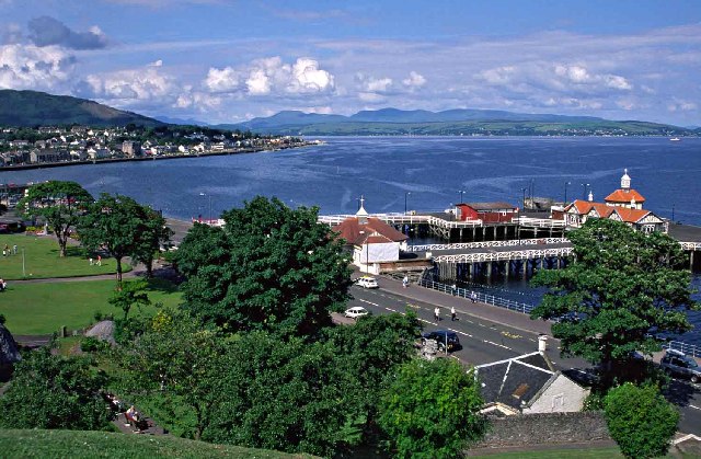
Dunoon's Victorian pier was extended to the current structure between 1896 and 1898.[33] It was shortened to allow the building of a breakwater in 2005, just to the south of the pier. As well as protecting the pier and its architecture from storm surges, a new link span was installed alongside the breakwater. This was to allow the berthing and loading of roll-on/roll-off ferries instead of the side-loading ferries that used to serve the pier. A tender to serve the new link-span between two interested parties, Caledonian MacBrayne and Western Ferries, came to nothing. Prior to June 2011, the pier was in daily use by Caledonian MacBrayne, who ran a regular foot passenger and car-ferry service to Gourock. However, after June 2011, a renewed tendering process produced a passenger-only ferry service (Argyll Ferries, owned by Caledonian MacBrayne) using the breakwater for berthing. On 1 September 2004, during the construction of the breakwater, the cargo vessel Jackie Moon (82 metres in length) ran aground on the breakwater, with six people on board. Since the breakwater became operational in June 2011, Argyll Ferries operate from this docking facility. The Waverley struck the breakwater on 26 June 2009, with some 700 people on board. The pier was partially refurbished by Argyll and Bute Council during 2015. Now containing meeting rooms, it is purely a tourist attraction.[34]
Burgh Hall
[edit]
Dunoon Burgh Hall opened in 1874, the work of notable Glasgow architect Robert Alexander Bryden, who is buried in Dunoon Cemetery, a mile to the north. It is a Scottish baronial-style building that housed the municipal offices and had a hall accommodating 500 people.[35] The Category B listed building re-opened in June 2017, and is a fully accessible venue for exhibitions, performances and gatherings. Alongside a gallery and theatre, the venue offers creative workshop space, a garden and a café.[36][37][38]
Other buildings
[edit]On 20 August 2021, several Argyll Street buildings were destroyed in an arson attack.[39]
Landmarks and attractions
[edit].jpg)
Mary Campbell, also known as "Highland Mary" and "Bonny Mary O' Argyll", was born at Auchamore Farm in Dunoon. She had a relationship with the bard Robert Burns.[40] The Highland Mary statue was erected in 1896; it is prominently sited on Castle Hill, overlooking the breakwater in Dunoon.[41][42][43][44][45] The statue is a scheduled monument (LB26437).[46]
The war memorial of Dunoon is located in the Castle Gardens, overlooking the pier.[47]
The Queen's Hall is the town's major multi-function hall complex.[48] It is situated opposite the head of the Victorian pier and built in 1958. It was officially opened by Queen Elizabeth II on 11 August 1958.[49]
Riverside Swim and Health Centre, including an indoor pool (25m long) and associated facilities, located on Alexandra Parade.
Dunoon Library is situated in the rebuilt Queens Hall at the Castle Gardens.[50]
A small group of rocks, known as the Gantocks, lie off the coast at Dunoon. The navigation beacon on the Gantocks in the Firth of Clyde is close to the coast at Dunoon. It was built in 1886.[51]
The Clan Lamont Memorial, also known as the Dunoon Massacre Memorial, is on Tom-A-Mhoid Road close to Castle Hill. It was dedicated in 1906 and commemorates the Dunoon massacre of 1646, when the Campbell Clan attacked the Lamont Clan, killing over 200 people.[52][53]
Local wildlife includes seals, otters, dolphins, basking sharks, roe deer, red deer, red squirrels, and many species of birds.[54]
The Castle House Museum opens during the summer season. It holds historical information and displays for Dunoon and the Cowal peninsula.[55]
Festivals
[edit]
The Cowal Highland Gathering, established in 1894, attracts contestants and spectators from all over the world.[56] It is held annually over the final weekend in August at Dunoon Stadium.[57]
Cowal Open Studios, held over a fortnight in September, gives the opportunity to visit the studios of artists around Dunoon and Cowal.
Cowalfest celebrates the outdoors activities like rambling around Dunoon for ten days in October.
Since the 1930s Dunoon has hosted the Royal National Mòd a number of times – 1930, 1950, 1968, 1994, 2000, 2006, 2012 and 2018.[58]
In 2013, the first Dunoon Film Festival was held over three days and opened with first public screening of Your Cheatin' Heart, a series made by the BBC that had last been shown on television in 1990.[59]
Transport
[edit]Dunoon is accessible by direct land and sea routes and indirectly by rail at Gourock.
Road
[edit]Dunoon lies towards the southern end of the A815 road. At its northernmost point, near Cairndow, this road joins the A83 and provides access to the town by road from Loch Lomond / Glasgow in the east, from Inveraray / Oban in the north and from Campbeltown in the west.
Ferry
[edit]Two ferry operators provide services to Dunoon from Gourock:
Caledonian MacBrayne

The public service route provided by the Scottish Government owned Caledonian MacBrayne, which is a foot-passenger-only service between Dunoon Breakwater and Gourock pier, giving easy access to the National Rail Network.[60]
| Preceding station | Ferry | Following station | ||
|---|---|---|---|---|
| Terminus | Caledonian MacBrayne Ferry |
Gourock |
Western Ferries
.jpg)
Local company Western Ferries (Clyde) LTD, carries motor vehicles and foot passengers between Hunters Quay near Dunoon and McInroy's Point on the A770, (Cloch Road).[61]
| Preceding station | Ferry | Following station | ||
|---|---|---|---|---|
| Terminus | Western Ferries Ferry |
McInroy's Point |
Travel connections
For foot passengers at Gourock Pier, a ScotRail train service provides access to the National Rail network at Glasgow Central, via the local service Inverclyde Line.[62]
Bus
[edit]Public transport within Dunoon and the surrounding area is provided under government subsidy by bus and coach operator West Coast Motors.
West Coast Motors' route 486 provides a regular return journey from Dunoon town centre to Inveraray, where it connects with a Scottish Citylink service 926 and 976 onward to Campbeltown, Oban, Glasgow and points in-between.[63] Route 478 runs from Dunoon Pier to Portavadie six days a week.[64]
Historical
[edit]

Modern Dunoon owes its existence to steam power; as late as 1822 there were only three or four slated houses, the rest of the residences being traditional Highland cottages.[65] In the New Statistical Account, the MP James Ewing from Glasgow is named as beginning the expansion of the village when he built Castle House close to Dunoon Castle.[66] The growth of the village increased from that time, paralleling the engineering-led growth of the steamers.[67] Other infrastructural advances also helped like the construction of a 130-yard-long (120-metre) jetty in 1835.[68] From 1812 to the late 1960s, thousands of holiday-makers travelled doon the watter from Glasgow and industrial Lanarkshire to Dunoon and to numerous other town piers on the Firth of Clyde.
In 1868, the following summer excursions by water could be had from Dunoon (going and returning the same day):[69]
- Ardentinny, Chancellor, 11 A.M.
- Ardrishaig, Iona, 9.30 A.M.
- Arran, Hero, 10.30 A.M.
- Arrochar, Chancellor, 11 A.M.
- Ayr, Vale of Clyde, 9.15 A.M.
- Blairmore, Chancellor, 11 A.M.
- Brodick, Hero, 10.30 A.M.
- Campbeltown, Gael, 9.15 A.M.
- Carradale, Gael, 9.15 A.M.
- Fairlie, Vale of Clyde, 9.15 A.M.
- Gareloch, early steamer to Greenock, thence per Garelochhead steamer
- Innellan, various during the day
- Kyles of Bute, to Tighnabruaich or Colintraive, Iona; Kilchattan Bay, Bute, Hero
- Lamlash, Hero, 10.30 A.M.
- Largs, Vale of Clyde, or early steamer to Innellan, thence cross by Wemyss Bay Railway Steamer to Wemyss Bay
- Lochgoil, Chancellor and Lochlong; change at Blairmore
- Loch Lomond, Chancellor or early steamer to Bowling, thence by rail to Balloch, thence by steamer to Tarbert, where cross to Arrochar, and catch Chancellor returning, or vice-versa
- Loch Long, Chancellor
- Millport, Vale of Clyde, 9.15 A.M.
- Rothesay, various during the day
- Tarbert, Iona
- Troon, Vale of Clyde
- Wemyss Bay, steamer to Innellan, thence cross by Wemyss Bay Railway Steamer to Wemyss Bay
Only one Clyde steamer, the Waverley, satisfies demand for this business today. It berths at the breakwater when visiting Dunoon during its summer season.[70]
Education
[edit]Dunoon is served by three primary schools. Dunoon Primary School is on Hillfoot Street; this building was the original 1641 location of Dunoon Grammar School. St Muns Primary School[71] is on Pilot Street and Kirn Primary School is on Park Road.[72]
Dunoon Grammar School is located on Ardenslate Road in Kirn.
The University of the Highlands and Islands' Argyll College has a campus in Dunoon, located in the West Bay, near the breakwater and Castle Hill.[73]
Sport and recreation
[edit]National Cycle Route 75
[edit]Dunoon is on the NCR75 a route from Edinburgh to Tarbert on the Kintyre peninsula.[74] The National Cycle Network is maintained by sustrans.[75]
Dunoon Stadium
[edit].jpg)
The town's sporting arena is Dunoon Stadium, which is located in the north of the town on Argyll Street. When it hosted football matches, it had the largest capacity of any amateur ground in Scotland.[citation needed] It later became the focal point of the Cowal Highland Gathering. Motorcycle dirt track racing (or speedway) was staged at the stadium on 18 June 1932 as part of the annual Dunoon and Cowal Agricultural Show. A demonstration event had been staged in May 1932.
The Dunoon Youth Football League (DYFL), founded in 1981, is a voluntary organisation that teaches football skills to all interested children with ages between 4 and 17. The DYFL have their own clubhouse and changing facilities at Dunoon Stadium. All coaches are parents who have received coaching certification through the Scottish Youth Football Association (SYFA), and the club has a PGA officer and coaches with Sports Injuries First Aid certification.
Cowal Rugby Club was formed in 1976. In 2008 it scored its first league victory in the Scottish Hydro Electric Western Regional League West Division 2.
Dunoon Amateurs F.C. was founded in 1975 and play football at Dunoon Stadium and Dunoon Grammar School.
Dunoon Camanachd was established in 2015; the shinty team started competing in South Division 2, in 2016.
Cowal Golf Club is situated on the hillside above Kirn. Founded in October 1891, initially as a nine-hole course designed by Willie Campbell from Bridge of Weir.[76] It was formerly an eighteen-hole course, reconstructed by James Braid between 1924 and 1928.[citation needed] The current clubhouse was built in 1996. Due to financial issues, club assets were sold off in 2020.[77] The golf club is still trading, although as a result of a land sale the course is now only a twelve-hole course. The club is now owned by "Cowal Golf and Lodge Resort Ltd.[78]
The two bowling clubs in Dunoon are Dunoon–Argyll Bowling Club, on Mary Street, and Bogleha' Bowling Club, on Argyll Street. They are two of the 21 members of Bowls Scotland's District 26.[79]
In 2006 and 2007, the town hosted a six-a-side swamp football tournament that attracted around 500 players and 1,000 spectators.[80][81]
Castle Tennis Club is situated in the town's Castle Garden. The club has two concrete and two all-weather courts, all lighted.
Every year in June, the town hosts the Argyll Rally, a motorsport event that takes place on closed public roads around the local area. The rally counts as a round of the Scottish Rally Championship and brings competitors from all over United Kingdom.[82]
Walks
[edit]
Trails (walks, running and mountain biking) thread through the hills surrounding Dunoon. Corlarach Hill has waymarked routes for walkers, mountain biking and horse riders.[83][84] These trails are located next to the Bishop's Glen.
Puck's Glen is a popular short walk set in the hills close to Benmore Botanic Garden. (The arboretum at Benmore Botanic Garden, formerly a private garden for the Younger family,[85] is now open to the public. It comprises 60 hectares (150 acres) and features some of the tallest trees in Britain, including the avenue of Giant Redwoods (Sequoia), some of which are over 37 metres (120 ft) high.[86] One of Dunoon's listed buildings is the Grade 2 Victorian fernery, which was reopened in 2009 after an 18-month restoration.)[87] Part of the Royal Botanic Garden Edinburgh, the Garden is 7 miles (11 kilometres) north of the town, just before Loch Eck. A tumbling burn, criss-crossed by bridges, is enclosed by rocky walls heavily hung with mosses and overshadowed by dense trees. The walk has clear, waymarked paths. The glen is named after Puck, from A Midsummer Night's Dream.[88]
Morag's Fairy Glen is a short gorge walk, with trails alongside the Berry Burn, located on the hill behind the West Bay area of Dunoon.[89][90][91]
The Bishop's Glen Reservoir trail follows the shore of the remaining one of three reservoirs in the glen, that used to supply fresh water to Dunoon.[92] The reservoir is damming the Balgaidgh Burn (Balgie) and is now a freshwater fly fishing location.[93] Access to the hills behind Dunoon, including Corlarach Hill, is available from the Bishop's Glen Reservoir trail.
Media
[edit]Dunoon's local weekly newspaper is the Dunoon Observer and Argyllshire Standard, which was founded in 1871 in Sandbank by editor and proprietor William Inglis Sr.[94][95] (The town once had three other newspapers, namely the Cowal Watchman (1876),[96] Dunoon Herald and Cowal Advertiser[97] and the Dunoon Telegraph.)[98]
Dunoon Community Radio was launched in 2009.[99] Broadcasting on 97.4 FM from the Dunoon Observer building, it is an independent social business entirely staffed by volunteers.
Notable people
[edit]- Virginia Bottomley, politician[100]
- Robert Alexander Bryden, architect, educated in Dunoon[101]
- Mary Campbell, love interest of Robert Burns[96]
- MT Carney, businesswoman[102]
- Donald Caskie, minister, educated in Dunoon[103]
- Peter Dorschel, spy, tried for espionage in Dunoon[104]
- William Fraser, architect, lived in Dunoon[105]
- Stewart Houston, footballer, born in Dunoon[106]
- Sir Harry Lauder (1870–1950), whose Laudervale mansion stood just south of Dunoon on Bullwood Road[107]
- Neil MacFarlane, footballer, born in Dunoon[108]
- Mackintosh MacKay, minister in Dunoon and Gaelic scholar[109]
- Sylvester McCoy, actor[110]
- Alexander Robertson, boatbuilder operating from boatyard near Dunoon[111]
- George Robertson, politician, educated in Dunoon[112]
- Arabella Scott, suffragette, born in Dunoon[113]
- Muriel Scott, suffragette, family home was in Dunoon[114]
- John Smith, politician, educated in Dunoon[115]
- Neil Warnock, football manager[116]
- Brian Wilson, politician[117]
Gallery
[edit]-
 Dunoon Grammar School Hostel
 -
 Entrance to Dunoon Grammar School
 -
 Pipe band at the Cowal Highland Gathering
 -
 Dunoon from above the Firth of Clyde, looking west
 -
 The eastern side of Dunoon Pier
 -
 Highland Mary statue
 -
 Castle House Gardens and war memorial, looking northeast to East Bay
 -
 The Gantocks from Dunoon, with Inverkip in the background to the east
 -
 Castle Hill, looking west
 -
 Firth of Clyde, from West Bay, Dunoon, Cowal, Argyll and Bute
.jpg)

.jpg)


Geography
[edit]Dunoon is on the west coast of the upper Firth of Clyde,[118] and on the east coast of the claw-shaped Cowal peninsula.
Much of the Cowal peninsula is covered with forest, particularly in the northern stretches and to the west and south with small patches in the south-east and east. To the north and north-west is the Argyll Forest Park that was established in 1935.[119]
Climate
[edit]As with the rest of the British Isles, Dunoon has a maritime climate with cool summers and mild winters. It is an exceptionally wet part of the country, particularly so for a place near sea-level, with annual average rainfall totals nearing 2,400 mm (94 in).
Recorded temperature extremes since 1960 range from 29.6 °C (85.3 °F) during July 1983[120] to as low as −13.9 °C (7.0 °F) during January 1982.[121]
| Climate data for Benmore Botanic Gardens 12m asl, 1971–2000, extremes 1960– (Weather station 7 mi (11 km) to the North of Dunoon) | |||||||||||||
|---|---|---|---|---|---|---|---|---|---|---|---|---|---|
| Month | Jan | Feb | Mar | Apr | May | Jun | Jul | Aug | Sep | Oct | Nov | Dec | Year |
| Record high °C (°F) | 14.4 (57.9) |
14.5 (58.1) |
17.2 (63.0) |
23.6 (74.5) |
27.0 (80.6) |
28.9 (84.0) |
29.6 (85.3) |
29.0 (84.2) |
25.1 (77.2) |
21.7 (71.1) |
16.5 (61.7) |
14.2 (57.6) |
29.6 (85.3) |
| Mean daily maximum °C (°F) | 6.5 (43.7) |
6.8 (44.2) |
8.6 (47.5) |
11.4 (52.5) |
14.9 (58.8) |
16.8 (62.2) |
18.4 (65.1) |
18.0 (64.4) |
15.3 (59.5) |
12.2 (54.0) |
8.9 (48.0) |
7.2 (45.0) |
12.1 (53.8) |
| Mean daily minimum °C (°F) | 1.0 (33.8) |
1.3 (34.3) |
2.2 (36.0) |
3.4 (38.1) |
5.8 (42.4) |
8.5 (47.3) |
10.7 (51.3) |
10.4 (50.7) |
8.6 (47.5) |
6.1 (43.0) |
2.9 (37.2) |
1.7 (35.1) |
5.2 (41.4) |
| Record low °C (°F) | −13.9 (7.0) |
−11.1 (12.0) |
−11.1 (12.0) |
−4.4 (24.1) |
−2.5 (27.5) |
−0.6 (30.9) |
2.2 (36.0) |
2.6 (36.7) |
−0.9 (30.4) |
−4.1 (24.6) |
−6.8 (19.8) |
−11.5 (11.3) |
−13.9 (7.0) |
| Average precipitation mm (inches) | 298.76 (11.76) |
214.43 (8.44) |
233.63 (9.20) |
119.48 (4.70) |
105.12 (4.14) |
108.54 (4.27) |
127.66 (5.03) |
160.85 (6.33) |
220.49 (8.68) |
257.6 (10.14) |
257.82 (10.15) |
282.98 (11.14) |
2,387.36 (93.98) |
| Source: Royal Dutch Meteorological Institute[122] | |||||||||||||
See also
[edit]References
[edit]- ^ "Population estimates for settlements and localities in Scotland: mid-2020". National Records of Scotland. 31 March 2022. Retrieved 31 March 2022.
- ^ Wells, John C. (2008). "Dunoon". Longman Pronunciation Dictionary (3rd ed.). Longman. ISBN 978-1-4058-8118-0.
- ^ "OS 25-inch map 1892–1949, with Bing opacity slider". National Library of Scotland. Ordnance Survey. Retrieved 12 October 2017.
- ^ "Dunoon Community Council | Home & Latest News". www.community-council.org.uk. Archived from the original on 1 August 2016. Retrieved 12 August 2020.
- ^ a b "Dunoon Burgh Hall Chronicles, issue 1" (PDF).[permanent dead link]
- ^ "Scottish phrase of the week: Doon the watter". www.scotsman.com. 21 October 2014.
- ^ www.samteq.co.uk, SAMTEQ. "Cowal Highland Gathering – World's Biggest Highland Games". Retrieved 21 February 2017.
- ^ info@reefnet.co.uk. "An Comunn Gàidhealach – Royal National Mod : Mod News". Retrieved 21 February 2017.
- ^ "Dunoon Castle". Canmore. Retrieved 11 December 2016.
- ^ "Gazetteer for Scotland: Dunoon". Scottish-places.info. Retrieved 14 December 2016.
- ^ a b "If you rebuild it, they will come: Unlocking local creativity 'doon the watter' | Jay Merrick"[permanent dead link] - The Academy of Urbanism
- ^ John COLEGATE (1868). Colegate's Guide to Dunoon, Kirn, and Hunter's Quay. Second edition. [With plates.]. John Colegate. p. 7. Archived from the original on 20 September 2021. Retrieved 30 December 2020.
- ^ a b Colegate's Guide to Dunoon, Kirn, and Hunter's Quay (Second edition) - John Colegate (1868), page 8
- ^ Colegate's Guide to Dunoon, Kirn, and Hunter's Quay (Second edition) - John Colegate (1868), page 12
- ^ "Clyde Defences, Cloch Point To Dunoon Anti-submarine Boom". Canmore. 3 July 2013. Retrieved 15 February 2017.
- ^ "Bute during World War II". www.bute-at-war.org.
- ^ "Anti-Polaris Protest at Dunoon. Angry Kerbside Exchanges". The Glasgow Herald. 15 May 1961. p. 8. Retrieved 11 December 2016.
- ^ "'Vulnerable' Scottish rural towns listed". BBC News. 28 May 2012. Retrieved 11 December 2016.
- ^ Cowling, Emma (27 May 2012). "Revealed: our rural towns on the brink". Scotsland on Sunday. Retrieved 11 December 2016.
- ^ "Scottish Parliamentary Election 6 May 2021 - Results". Argyll and Bute Council. 6 May 2021. Retrieved 14 June 2021.
- ^ "Argyll & Bute parliamentary constituency - Election 2019". Retrieved 14 December 2019.
- ^ "Declaration of Results: Ward 7, Dunoon" (PDF). Argyll and Bute Council. 5 May 2017. Archived from the original (PDF) on 16 June 2021. Retrieved 15 June 2021.
- ^ "Community councils map". Argyll and Bute Council. Retrieved 14 June 2021.
- ^ "community councils". Argyll and Bute Council. 14 November 2012. Retrieved 14 June 2021.
- ^ "Our Lady and St Mun's Church Dunoon". stmuns. Archived from the original on 27 July 2020. Retrieved 27 July 2020.
- ^ "Cowal Baptist Church, Dunoon". 24 September 2017.
- ^ "Dunoon Baptist Church – Working, Worshipping and Witnessing for God in the community". dunoonbaptistchurch.org.
- ^ "Kingdom Hall Of Jehovah'S Witnesses - Church - Dunoon Argyll & Bute UK". dunoon.inuklocal.co.uk.
- ^ DUNOON CONSERVATION AREA APPRAISAL and CONSERVATION STRATEGY, 2017 Archived 23 July 2020 at the Wayback Machine - Argyll & Bute Council
- ^ "End of an era as Dunoon's High Kirk set to close". cowalkirk.org.
- ^ "Church". Free Church of Scotland.[permanent dead link]
- ^ Ordnance Gazetteer of Scotland: A Graphic and Accurate Description of Every Place in Scotland, Frances Hindes Groome (1901), p. 444
- ^ DUNOON PIER WITH WAITING ROOMS AND PIER MASTER'S OFFICE, SIGNAL TOWER AND ADJOINING TEAROOM, TICKET LODGE, PIER RAILINGS Archived 20 June 2019 at the Wayback Machine – Historic Environment Scotland
- ^ "Dunoon". National Piers Society. 10 June 2015. Archived from the original on 21 November 2016. Retrieved 12 December 2016.
- ^ "Dunoon's culture and events hub". Dunoon Burgh Hall. Retrieved 20 February 2017.
- ^ "Hall reopens as contemporary arts centre". BBC News. 19 June 2017. Retrieved 21 May 2018.
- ^ "Burgh Hall". Theatres Database. The Theatres Trust. Retrieved 20 February 2017.
- ^ Historic Environment Scotland. "Argyll Street, Burgh Hall Building (LB26439)". Retrieved 19 June 2025.
- ^ "Two charged after town centre fire" – ArgyllBute24.co.uk
- ^ "The Creation and Controversy of Dunoon's Highland Mary". Castle House Museum. 21 June 2022.
- ^ "Robert Burns and Highland Mary". Portal to the Past. Archived from the original on 20 December 2016. Retrieved 14 December 2016.
- ^ Caw, James (1912). . Dictionary of National Biography (2nd supplement). Vol. 3. pp. 413–414.
- ^ "Statue Of 'Highland Mary'". Portal.historicenvironment.scot. Retrieved 11 January 2017.
- ^ "Robert Burns Country: The Burns Encyclopedia: Highland Harry". Robertburns.org. Retrieved 22 November 2016.
- ^ Webmaster, Tim Gardner -. "David Watson Stevenson (1842–1904), sculptor, a biography".
- ^ "STATUE OF "HIGHLAND MARY" (LB26437)". portal.historicenvironment.scot.
- ^ "Dunoon Cenotaph WW1 and WW2 - War Memorials Online". www.warmemorialsonline.org.uk.
- ^ "The Queens Hall – Dunoon | Argyll and Bute Council". Argyll-bute.gov.uk. Retrieved 22 November 2016.
- ^ "Dunoon Queens Hall Meet the Buyer – Supplier Development Programme". Sdpscotland.co.uk. Retrieved 11 January 2017.
- ^ "Dunoon Library".
- ^ "Secret Scotland - The Gantocks". Secret Scotland.
- ^ Historic Environment Scotland. "Dunoon, Tom A Mhoid Road, Clan Lamont Memorial (Site no. NS17NE 85)". Retrieved 19 June 2025.
- ^ "Clan Lamont Memorial, Dunoon". Commemorations Project. The Scottish Military Research Group. Retrieved 21 February 2017. Includes several photographs
- ^ "Where to Find wildlife – visitcowal". Retrieved 21 February 2017.
- ^ "Castle House Museum Dunoon. History, culture, geneaology services, clans and exhibitions". Castlehouse Museum. Retrieved 22 November 2016.
- ^ "COWAL HIGHLAND GATHERING (1974)". Moving Image Archive. National Library of Scotland. Retrieved 11 July 2018.
- ^ "Cowal Highland Gathering – World's Biggest Highland Games". Cowalgathering.com. Retrieved 22 November 2016.
- ^ List of Mod's places for each year on Sabhal Mòr Ostaig website
- ^ "Your Cheatin' Heart to open first Dunoon Film Festival". BBC News. 10 May 2013.
- ^ "Gourock to Dunoon Service | CalMac Ferries". Calmac Ferries.
- ^ "Western Ferries (Clyde) Ltd". Western Ferries.
- ^ "Train to and from Gourock | ScotRail". Scotrail.
- ^ "486 - Dunoon to Inveraray". West Coast Motors. Archived from the original on 24 July 2020.
- ^ "SCOTLAND'S BERMUDA TRIANGLE". www.keybuses.com. 21 May 2020. Retrieved 26 September 2023.
- ^ Macdonald, Hugh (1878). Days at the coast : a series of sketches descriptive of the Firth of Clyde, its watering places, its scenery, and its associations. Glasgow: Dunn. p. 346. Retrieved 11 July 2018.
- ^ Mackay, M (1845). The new statistical account of Scotland (Vol 7 ed.). Edinburgh and London: W. Blackwood and Sons. p. 607. Retrieved 11 July 2018.
- ^ "OS 6-inch map 1843–1882, with Bing opacity slider". National Library of Scotland. Ordnance Survey. Retrieved 12 October 2017.
- ^ Williamson, James (1904). The Clyde passenger steamers : its rise and progress during the nineteenth century : from the 'Comet' of 1812 to the 'King Edward' of 1901. Glasgow: J. Maclehose. p. 78. Retrieved 11 July 2018.
- ^ John COLEGATE (1868). Colegate's Guide to Dunoon, Kirn, and Hunter's Quay. Second edition. [With plates.]. John Colegate. p. 13. Retrieved 30 December 2020.
- ^ Taylor, Marianne (9 May 2015). "The Waverley: Paddling doon the watter for 40 years". The Herald. Retrieved 11 December 2016.
- ^ Council, Argyll and Bute (3 November 2010). "St Muns Primary School".
- ^ Council, Argyll and Bute (31 January 2018). "Kirn Primary School". Kirm Primary School.
- ^ "Argyll College UHI". University of the Highlands and Islands. Archived from the original on 20 December 2016. Retrieved 7 December 2016.
- ^ "National Cycle Network routes in Glasgow and the West". Sustrans.
- ^ "About us". Sustrans.
- ^ "Activities". Castle Lachlan.
- ^ "Cowal Golf Course and Clubhouse, 20-44 Ardenslate Road, Dunoon, Kirn, PA23 8LT". Novaloca.com.
- ^ "COWAL GOLF AND LODGE RESORT LTD overview - Find and update company information - GOV.UK". find-and-update.company-information.service.gov.uk.
- ^ "District 26 | Bowls Scotland 2024". www.bowlsscotland.com. Retrieved 2 August 2024.
- ^ "Dunoon swamped by football fans". BBC News. 1 July 2006. Retrieved 11 December 2016.
- ^ "'Swamp soccer' teams play dirty". BBC News. 16 July 2007. Retrieved 11 December 2016.
- ^ "Argyll Rally Homepage". Argyll Rally. Retrieved 9 February 2019.
- ^ "Explore woods: Corlarach Hill". The Woodland Trust. Archived from the original on 24 November 2016. Retrieved 11 December 2016.
- ^ "Corlarach". Forestry Commission Scotland. Retrieved 11 December 2016.
- ^ "Younger Family at Benmore". Archived from the original on 4 April 2021. Retrieved 25 July 2020.
- ^ "Royal Botanic Garden Edinburgh – Benmore Botanic Garden". Rbge.org.uk. 8 March 2016. Archived from the original on 14 April 2009. Retrieved 22 November 2016.
- ^ "Gardens: Benmore Botanic Garden, Dunoon, Argyll". The Scotsman. 17 October 2009. Retrieved 12 January 2017.
- ^ "Puck's Glen". Government of the United Kingdom. Archived from the original on 9 March 2017. Retrieved 22 November 2016.
- ^ "Dunoon Visitor Guide - Accommodation, Things To Do & More". Visit Scotland.
- ^ "Morag's Fairy Glen, West Bay,Dunoon". 28 March 2015.
- ^ "Morag's Fairy Glen". CANMORE national record of the historic environment. Retrieved 31 May 2021.
- ^ "Dunoon Visitor Guide - Accommodation, Things To Do & More". Visit Scotland.
- ^ "..Dunoon Reservoir". 19 March 2015.
- ^ "History of the Dunoon Observer". Dunoon-observer.com. Retrieved 9 April 2012.
- ^ "Centenery Issue". Evening Times. 29 March 1971. p. 4. Retrieved 24 March 2024.
- ^ a b Ordnance Gazetteer of Scotland A Graphic and Accurate Description of Every Place in Scotland (1901) - p. 1330
- ^ The Dunoon Herald and Cowal Advertiser at WorldCat.org
- ^ The Dunoon telegraph at WorldCat.org
- ^ "Dunoon, Cowal, Argyll, Scotland radio station, English and Gaelic programmes". Dunoon Community Radio. Retrieved 14 January 2012.
- ^ "MP double act for Conservatives Abroad". Majorca Daily Bulletin. 22 September 2004. Retrieved 9 October 2022.
- ^ "Robert Alexander Bryden". Dictionary of Scottish Architects. Retrieved 9 October 2022.
- ^ "Carney Arrives At UM in N.Y." Ad Week. 16 June 2003.
- ^ "The Rev. Dr. Donald Currie Caskie, OBE, DD, MA, OCF". Clan Macpherson Association. 2012. Retrieved 25 November 2016.
- ^ "German for sentence in secrets case". The Guardian. Manchester. 20 June 1967. p. 3. ProQuest 185247880. (subscription required)
- ^ "Dunoon regeneration – Queens Hall Project". Argyll and Bute Council's website. 8 July 2014. Retrieved 27 August 2020.
- ^ "Stewart Mackie Houston". MUFC Info. Retrieved 9 October 2022.
- ^ Phil Miller (23 April 2010). "Fly me to Dunoon ... Scottish bid for de Niro's film festival". Herald Scotland. Retrieved 27 October 2011.
- ^ Neil MacFarlane at Soccerbase
- ^ Scott, Hew (1923). Fasti ecclesiae scoticanae; the succession of ministers in the Church of Scotland from the reformation. Vol. 4. Edinburgh: Oliver and Boyd. p. 24.
{{cite book}}: CS1 maint: publisher location (link) This article incorporates text from this source, which is in the public domain.
- ^ "Sylvester McCoy". BFI. Archived from the original on 28 May 2016. Retrieved 9 January 2022.
- ^ Hutchison, David (21 May 2013). "Largs to Brisbane – Tragic Voyage of the Southern Cross". Ayrshire History. Retrieved 9 October 2022.
- ^ "Rt Hon Lord Robertson KT of Port Ellen KT GCMG". The British Forces Foundation. Retrieved 9 October 2022.
- ^ "Arabella Scott". National Records of Scotland. Retrieved 9 October 2022.
- ^ Leneman, Leah (1995). A Guid Cause: the women's suffrage movement in Scotland. Mercat Press. pp. 194–208.
- ^ "John Smith". Gazetteer for Scotland. Retrieved 9 October 2022.
- ^ "Neil Warnock was close to Hearts job and wants to manage in Scotland". BBC Sport. 22 November 2023. Retrieved 23 November 2023.
- ^ Bernard Ingham; Gerry Hassan (2003). The Political Guide to Modern Scotland: People, Places and Power. Politico's. pp. 104–105. ISBN 978-1-84275-048-3. Retrieved 30 December 2020.
- ^ "Dunoon Feature Page on Undiscovered Scotland". Undiscovered Scotland.
- ^ "Argyll Forest Park". Forestry Commission Scotland. Archived from the original on 29 March 2019. Retrieved 30 December 2020.
- ^ "1983 Maximum". Royal Netherlands Meteorological Institute. Archived from the original on 2 June 2012. Retrieved 3 November 2011.
- ^ "1982 Minimum". Royal Netherlands Meteorological Institute. Archived from the original on 2 June 2012. Retrieved 3 November 2011.
- ^ "Benmore averages". KNMI. Archived from the original on 2 June 2012. Retrieved 3 November 2011.
External links
[edit]- Map sources for Dunoon
Destinations from Dunoon | |
|---|---|
| International | |
|---|---|
| National | |
| Geographic | |
| Other | |
Dunoon
View on GrokipediaDunoon is a coastal town and former burgh on the Cowal Peninsula in Argyll and Bute, Scotland, positioned on the western shore of the upper Firth of Clyde opposite Gourock.[1][2] With a population of approximately 7,800 in the surrounding ward, it serves as the principal settlement and economic hub of the Cowal area, reliant on tourism and ferry connectivity.[3] The town operates as a vital passenger ferry port, providing Scotland's busiest crossing to the mainland via services to Gourock, which facilitate access for residents and visitors to the broader Glasgow conurbation.[4] Dunoon gained burgh status in 1868 and is notably home to the annual Cowal Highland Gathering, established in 1894 and recognized as one of the largest and most prestigious Highland games events worldwide, drawing around 23,000 attendees each August for competitions in piping, dancing, and heavy athletics.[5][6]
Geography
Location and Topography
Dunoon occupies a position on the Cowal Peninsula within the Argyll and Bute council area of western Scotland, situated at latitude 55.9467°N and longitude 4.9241°W.[7] The town lies along the western shore of the upper Firth of Clyde, facing eastward toward Gourock on the mainland approximately 2 miles (3.2 km) across the water. To its north rests the mouth of Holy Loch, while southward extends toward Hunter's Quay and the Kyles of Bute, providing sheltered waters conducive to maritime activity.[8] The Cowal Peninsula, on which Dunoon stands as the principal settlement, projects ruggedly into the Atlantic approaches, delimited by Loch Long to the northeast, the Kyles of Bute to the south, and Loch Fyne to the west.[8] This configuration isolates Cowal from the Scottish Lowlands, integrating it into the Highland fringe with its associated geological and climatic influences.[9] The peninsula's eastern boundary follows the fault line of the Highland Boundary Fault, contributing to the varied terrain observable around Dunoon.[10] Topographically, Dunoon centers on a low-lying coastal strip at an average elevation of 10 metres (33 feet) above sea level, encompassing East Bay and West Bay where the town expands along a 2-mile esplanade.[11] Immediately westward, the ground ascends via Castle Hill—a modest prominence reaching about 50 metres—to merge into the broader Cowal Hills, characterized by steep gradients, moorland plateaus, and conifer plantations. These hills, part of the Grampian massif's southern extent, feature elevations exceeding 500 metres in proximity, such as those in the Bishop's Glen area, fostering a transition from shoreline to upland within short distances.[8] The underlying geology comprises Dalradian schists and Old Red Sandstone, shaped by glacial erosion into U-shaped valleys and rocky outcrops visible in the local landscape.[10]
Climate
Dunoon features a temperate oceanic climate (Köppen classification Cfb), characterized by mild temperatures, high humidity, persistent cloud cover, and abundant precipitation influenced by its coastal position on the Firth of Clyde and proximity to the Atlantic Ocean via the North Atlantic Current.[12][13] This results in relatively stable conditions with few extremes, though frequent westerly winds contribute to a bracing feel, especially in winter.[11] Annual mean temperature stands at 8.2 °C, with winters cool and summers mild; January averages 6 °C daytime highs and 2 °C lows, while July and August peak at around 18 °C highs and 11 °C lows.[14][11] Frost occurs occasionally but rarely drops below -4 °C, and summer highs seldom exceed 22 °C.[11] Precipitation totals approximately 1,436 mm annually, spread over about 185 days, with winter months wettest—January averaging 185 mm—and spring driest, May at 105 mm.[15][14] Snow is infrequent and typically light, melting quickly due to mild air masses, while rain dominates, often accompanied by overcast skies averaging less than 30% clear days year-round.[11]History
Early and Medieval Periods
The parish of Dunoon is regarded as one of the most ancient in Scotland, with ecclesiastical origins traceable to early medieval times through its association with the broader diocese of Argyll.[16] During this period, the area formed part of the Cowal Peninsula, controlled primarily by Clan Lamont, a Highland clan of probable Norse-Irish descent that held extensive lands across Cowal from at least the 13th century.[17] The Lamonts, deriving their name from Old Norse for "lawman," maintained strongholds throughout the region, reflecting their dominance in local governance and feuds.[18] Dunoon Castle, perched on a prominent conical hill overlooking the Firth of Clyde, emerged as a key medieval stronghold, with documentary evidence confirming its existence by the early 13th century and archaeological indications of possibly earlier early medieval foundations.[19] Initially under Lamont stewardship, the castle served strategic purposes at the Clyde estuary's entrance, functioning as a royal residence and hunting lodge for Scottish monarchs, including during the reigns of 14th- and 15th-century Stewart kings like Robert II, who utilized it amid regional power consolidations.[20] By the mid-14th century, the Campbells of Lochow gained control, with Sir Colin Campbell, 3rd Lord of Lochow, appointed Hereditary Keeper around 1368, marking a shift in custodianship amid ongoing clan rivalries that foreshadowed later conflicts.[21] The site's defensive earthworks and stone structures underscored its role in medieval Argyll's feudal landscape, though no major battles are recorded there prior to the post-medieval era.[22]18th-19th Centuries: Clearances and Victorian Growth
During the 18th century, Dunoon emerged as a modest coastal settlement on the Cowal Peninsula, with initial infrastructure developments including a stone jetty constructed around 1767 to support rudimentary maritime activity.[23] The surrounding Argyll region underwent agricultural transformations and estate improvements, contributing to rural population declines as tenants shifted toward larger farms and sheep rearing, though documented instances of violent evictions in Cowal were limited compared to more northern Highland estates.[24] These shifts displaced some inland residents toward coastal areas like Dunoon, where fishing and trade provided alternative livelihoods amid broader post-Culloden economic pressures on clan-based tenantry.[24] The early 19th century marked a pivot toward tourism-driven expansion, accelerated by advancements in steam navigation that shortened travel times from Glasgow to under two hours by the 1820s. In 1822, Glasgow merchant James Ewing erected a substantial mansion overlooking the pier, exemplifying how affluent urban investors catalyzed villa construction and elite visitation, which in turn stimulated local commerce and infrastructure.[25] This development presaged Dunoon's Victorian-era boom, as paddle steamers enabled day trips and seasonal holidays for Glasgow's burgeoning middle and working classes, fostering hotels, promenades, and boarding houses by mid-century.[26] By the late 19th century, Dunoon's population and built environment had expanded markedly, with the original timber pier upgraded multiple times to handle increased steamer traffic—peaking at over 2 million annual passengers in the 1880s—and supporting a local economy increasingly oriented toward leisure rather than subsistence agriculture.[23] Agricultural rationalization in the hinterlands indirectly bolstered this growth by channeling displaced labor into service roles, though the town's prosperity hinged more on Clyde estuary accessibility than clearance-induced migration alone.[25]20th Century: Wars and Economic Shifts
During the First World War, Dunoon contributed significantly to Britain's war effort through local enlistments, particularly in regiments such as the Argyll and Sutherland Highlanders, with the town's war memorial listing 396 names of those who served and died.[27] Coastal defenses were established, including Defence Electric Lights at Dunoon to illuminate targets for guns at nearby Cloch Point, reflecting the strategic importance of the Firth of Clyde.[28] The war disrupted the local tourism economy, which had been thriving in the early 20th century as a popular Clyde resort for Glaswegians; the outbreak in August 1914 halted the mid-season tourist influx, and the loss of American visitors persisted throughout the conflict.[29] In the interwar period, Dunoon's economy remained anchored in seasonal tourism, bolstered by steamer services from Glasgow, though broader Scottish industrial depression limited diversification.[30] The Second World War further interrupted growth, with Dunoon Castle repurposed as a defense site featuring searchlights and gun emplacements, and the nearby Holy Loch serving as a Royal Navy submarine base.[31] The town's memorial records 78 fatalities from the war, underscoring the human cost amid these military roles.[27] Post-1945, tourism briefly recovered, restoring Dunoon's status as a holiday destination, aided by increased car ownership and bus excursions.[24] However, by the mid-20th century, the rise of affordable foreign package holidays eroded its prominence as a seaside resort, signaling an economic shift away from traditional Clyde steamer-based leisure toward broader challenges in sustaining visitor numbers before later developments.[30][32] Fishing persisted as a minor sector, with modern vessels enabling farther operations, but tourism's volatility highlighted the town's vulnerability to external travel trends.[24]Cold War Era: Holy Loch Base and Protests
During the Cold War, Holy Loch, adjacent to Dunoon, served as a forward base for the United States Navy's ballistic missile submarines from 1961 to 1992. The base was established on 3 March 1961 when the submarine tender USS Proteus arrived in the loch to support the Polaris nuclear missile program, providing maintenance and logistics for submarines carrying submarine-launched ballistic missiles as part of NATO's nuclear deterrent against the Soviet Union.[33] This deployment marked the only permanent U.S. naval submarine facility in Europe during the period, with rotating crews and support personnel numbering in the hundreds, peaking with tenders like USS Canopus from 1970 to 1975.[34] The presence of the base significantly boosted Dunoon's local economy, which had been declining post-World War II. Thousands of jobs were created directly and indirectly, with local residents employed in support roles and American personnel stimulating retail, housing, and services; by the late 1980s, the base contributed millions in economic activity annually.[35] Socially, it led to an influx of U.S. families, with approximately 360 American children attending local Scottish primary schools and 100 at Dunoon Grammar School just before closure in 1991, fostering cultural exchanges but also occasional tensions over land use and infrastructure strain.[36] Opposition to the base manifested in protests organized primarily by the Campaign for Nuclear Disarmament (CND) and local peace groups, viewing the Polaris deployment as escalating nuclear risks. On 4 March 1961, about 1,000 demonstrators marched in Dunoon to protest the base's establishment, with sit-down actions and confrontations near the loch; similar demonstrations continued sporadically through the 1960s and into the 1980s, including blockades of naval vessels.[37] While CND framed the protests as resistance to nuclear militarization, local support often prioritized economic benefits, leading to divisions within the community; arrests occurred during some events, but the demonstrations did not prevent the base's long-term operation.[38] The facility's strategic role persisted until its announced closure on 6 February 1991 amid the Soviet Union's dissolution, with final withdrawal in March 1992.[39]Post-Cold War: Decline and Regeneration Efforts
The closure of the U.S. Navy's Holy Loch base in June 1992, following the withdrawal of the last submarine, precipitated a sharp economic downturn in Dunoon, as the facility had contributed approximately £56 million annually to the local economy and supported around 800 jobs in sectors such as hospitality, transport, and retail.[40][41] With nearly a quarter of the area's population tied to American personnel and dependents by 1991, the departure exacerbated unemployment, which rose alongside high rates of benefit claimants, vacant commercial premises in the town center, and an ageing demographic profile that hindered recovery.[1][42][43] Regeneration initiatives gained momentum in the late 2000s and 2010s, emphasizing tourism and infrastructure renewal to offset the loss of military spending. Argyll and Bute Council allocated £2.8 million for the refurbishment of Dunoon's Victorian pier, restoring its structural integrity and enhancing appeal for passenger ferries and events, which helped sustain maritime links to Gourock.[44] Community-led efforts, including the Dunoon Project launched around 2020, focused on developing trails, viewpoints, and access to the town's hilly backdrop to promote outdoor recreation and attract visitors seeking natural experiences over former military associations.[45][26] Further recovery strategies positioned Dunoon as an adventure hub, with proposals in 2019 for a community buyout of Corlarach Forest to create facilities for activities like mountain biking and hiking, aiming to revive the town's status as a tourist destination.[46] The ThinkDunoon charrette process established a framework integrating conservation and development, while broader economic plans addressed persistent challenges like population stagnation through targeted investments in services and events.[47][48] Some observers noted ancillary benefits from the base's closure, such as increased civilian tourism from visitors previously deterred by its presence, though overall economic metrics indicated slower progress amid Scotland's regional disparities.[49][42]Demographics
Population Dynamics
According to the 2011 census, the population of the Dunoon settlement area stood at 9,960, reflecting a modest 1.6% increase from 9,803 in 2001, driven partly by residual economic ties to tourism and local services despite broader regional stagnation.[50] By the 2022 census, this had declined to 7,994, equating to an average annual decrease of 0.67% over the intervening decade, consistent with net out-migration and limited inward investment.[51] These trends align with the wider Cowal peninsula, where Bute and Cowal's population fell 9% between 2002 and 2021, contrasting Scotland's 8% growth over the same period; key drivers included an aging demographic, with higher death rates and lower birth rates than national averages, compounded by younger residents departing for employment opportunities elsewhere.[52] The U.S. Navy's Holy Loch submarine base, operational from 1961 to 1992, had previously mitigated decline by employing or servicing up to a quarter of the local workforce by the early 1990s, sustaining ancillary population stability through indirect economic multipliers like retail and housing demand, though permanent residency growth remained tempered by the transient nature of base personnel.[1][42] Post-closure economic contraction accelerated depopulation, as the loss of base-related jobs—estimated to impact half the town's livelihoods—fueled unemployment and benefit dependency, deterring family formation and retention; Argyll and Bute as a whole saw a 0.31% drop (270 people) between mid-2023 and mid-2024, underscoring persistent structural challenges like peripheral location and ferry reliance.[35][53] Efforts to reverse this through regeneration, such as tourism revival, have yielded below-average growth, with Dunoon's population trajectory remaining negative amid Scotland's uneven recovery.[54]Ethnic and Cultural Composition
Dunoon's population exhibits a high degree of ethnic homogeneity, with 7,794 individuals (97.6% of the total 7,994 residents) identifying as White in the 2022 census.[51] Minority ethnic groups are minimal, comprising Asian residents (79, or 1.0%), African or Caribbean (28, 0.4%), mixed ethnicity (26, 0.3%), and other ethnicities (13, 0.2%).[51] This composition aligns with broader patterns in rural Argyll and Bute, where White Scottish or other British identities predominate, contrasting with Scotland's national minority ethnic share of 12.9%.[55] Culturally, Dunoon reflects traditional Scottish heritage rooted in the Cowal Peninsula's Gaelic and Highland history, though contemporary life is English-speaking and oriented toward Lowland Scottish norms. The annual Cowal Highland Gathering, established in 1896, underscores this with competitions in piping, Highland dancing, and athletics, drawing over 20,000 attendees and preserving clan-based traditions like those of the Lamonts, historically prominent in the area.[56] Gaelic revival efforts persist through local choirs and school units, but speakers remain few, with Argyll's overall Gaelic proficiency low compared to the Western Isles.[57] Religiously, Protestantism dominates via the Church of Scotland (1,991 adherents, approximately 25%), followed by Roman Catholicism (524, 6.6%), other Christians (276, 3.5%), and no religion (2,130, 26.7%), reflecting secularization trends while maintaining Presbyterian cultural influence through institutions like the High Kirk.[51] Community events and heritage sites, such as the Highland Mary statue commemorating Robert Burns' associate, further embed Romantic Scottish literary and folk elements in local identity.[56]Economy
Traditional Industries and Transitions
The economy of Dunoon and the broader Cowal Peninsula historically centered on agriculture, forestry, and small-scale fishing, reflecting the rural character of the region. Upland sheep farming and related pastoral activities provided a foundational livelihood, while forestry contributed through timber extraction and land management, with woodlands covering significant portions of the peninsula. Fishing in the Firth of Clyde, including herring stocks that supported local efforts until their collapse by the mid-1980s due to overexploitation and environmental factors, supplemented these activities, though Dunoon lacked large-scale commercial fleets compared to other Clyde ports.[58] A key transition began in the mid-20th century with the establishment of the U.S. Navy's Holy Loch submarine base in 1961, which shifted local reliance toward defense-related services and support industries. The base employed thousands of personnel and stimulated ancillary economic activity, including retail, hospitality, and construction, with up to 25% of the area's workforce directly or indirectly dependent on it by the early 1990s.[35] This influx diversified the economy away from primary sectors, fostering population growth and infrastructure development in Dunoon.[33] The base's closure in 1992, following the Cold War's end, triggered sharp economic contraction, with local unemployment rising and businesses closing due to lost revenue from American personnel.[35] Subsequent transitions emphasized tourism revival and service-oriented regeneration, though challenges persisted from reduced ferry traffic and outmigration, prompting policy interventions like waterfront redevelopment to rebuild viability.[33] Agriculture and forestry retained roles in the rural hinterland, comprising over 9% of Argyll and Bute's workforce as of recent assessments, amid ongoing debates over land use shifts toward renewables.[59]Modern Sectors: Tourism and Services
Tourism serves as Dunoon's principal modern economic driver, leveraging the town's coastal position on the Firth of Clyde and frequent ferry links to Gourock for day trippers from the Glasgow conurbation. Key attractions include the annual Cowal Highland Gathering, the largest Highland games event globally, which attracts thousands of participants and spectators in late August and generates approximately £1.5 million in local economic impact alongside 22 full-time equivalent jobs.[60] In 2024, Dunoon's major events collectively injected £901,000 into the regional economy through visitor spending on accommodations, food, and transport.[61] Emerging adventure tourism initiatives further bolster the sector, with developments such as a proposed Dunoon Adventure Resort—partnering with Nevis Range for all-season facilities—and a new bike hire and repair center targeting Scotland's expanding mountain biking market.[62][63] These efforts aim to diversify beyond traditional seaside visits, capitalizing on nearby trails and water activities to draw international and domestic adventure seekers. The historic pier remains central, historically accommodating thousands of summer tourists and facilitating cruise excursions.[64] The services sector, encompassing hospitality, retail, and visitor-related provisions, underpins tourism's viability in Dunoon. In Argyll and Bute, tourism-related services constitute about 25% of private sector employment, reflecting a post-naval base transition from military dependency to visitor-oriented operations.[65] Earlier data from 2006–2007 indicate 84,600 staying visitors to Dunoon contributed £4.3 million, underscoring services' role in sustaining year-round, albeit seasonal-peaking, economic activity.[42]Challenges and Policy Responses
Dunoon's economy, reliant on seasonal tourism and service sectors, faces structural challenges including geographic isolation exacerbated by ferry service limitations and the 2011 cessation of the town-center vehicle ferry link to Gourock, which correlated with increased benefit claimant rates in the area from 2011 to 2012 while they declined regionally.[42] This dependency hinders reliable access to mainland employment and markets, contributing to higher-than-average historical unemployment in wards like Milton and Ardenslate (JSA claimants more than double Argyll and Bute averages in 2013) and elevated incapacity benefit claims (13-15% in affected areas versus 6% locally in 2012).[42] Town center vacancy rates stood at approximately 10.6% in 2010 (16 of 151 units), with indications of subsequent rises amid broader retail pressures, though some assessments note rates below national averages by 2024; these vacancies reflect limited diversification beyond tourism, which suffers from inadequate active travel infrastructure and coastal inaccessibility, constraining visitor spend and local service viability.[42] [66] High business costs, housing shortages, and poor digital connectivity further impede service sector growth and retention of working-age residents, aligning with Dunoon's ranking in top deciles for deprivation indicators like poverty.[67] Policy responses have centered on regeneration and connectivity enhancements under Argyll and Bute Council's frameworks, including the Dunoon Conservation Area Regeneration Scheme (CARS), which allocated over £1.6 million from Historic Environment Scotland and council funds to upgrade historical buildings, shopfronts on Argyll Street, and traditional skills training, aiming to revitalize tourism appeal and town-center footfall.[68] The 2023 Argyll and Bute Economic Strategy, informed by place-based assessments, recommends bolstering active travel networks and leisure cycling to support sustainable tourism, alongside digital infrastructure improvements for service resilience and public transport affordability to mitigate ferry barriers.[67] Complementary initiatives via the Dunoon Area Alliance and Scottish Government Town Centre Action Plan emphasize unlocking underused land for enterprise, partnering on affordable housing to address shortages, and fostering sectors like renewables and creative industries, with ongoing feasibility studies exploring non-subsidized vehicle ferry options to reduce economic isolation.[69] [70] [42] These efforts seek to leverage Dunoon's natural assets while countering depopulation drivers, though measurable impacts remain tied to transport reliability and external funding continuity.[71]Government and Politics
Local Administration
Dunoon is administered as part of the unitary authority of Argyll and Bute Council, established in 1996 under the Local Government etc. (Scotland) Act 1994, which handles local services including education, planning, waste management, and community development across its expansive jurisdiction—the second-largest council area in Scotland by land area.[72] The council's headquarters are in Lochgilphead, but Dunoon falls within the Cowal ward system, specifically the Dunoon electoral ward, represented by Councillor Daniel Hampsey of the Scottish Conservative and Unionist Party, who can be contacted via council channels for local issues.[73] At the community level, the Dunoon Community Council serves as a statutory advisory body under the Local Government (Scotland) Act 1973, comprising elected local residents who represent community interests, engage with Argyll and Bute Council on planning and development matters, and facilitate grassroots initiatives such as regeneration projects and public consultations.[74] Current office-bearers include Convener Gillian Robertson, Secretary Tom McCowan, Treasurer Timothy Moss, and Vice-Convener Tom Warren, with the council holding regular meetings to voice resident concerns and collaborate on local priorities like economic revitalization.[75] Adjacent areas like Hunter's Quay have separate community councils, reflecting Scotland's tiered structure where these bodies provide non-executive input without formal decision-making powers.[76] Historically, Dunoon operated as a police burgh from 1868, following the Burgh Police (Scotland) Act 1833 and subsequent reforms, which granted it self-governing status for urban services, leading to the election of commissioners and the construction of the Burgh Hall in 1874 as a municipal hub.[77] This era saw local administration focused on infrastructure like piers and sanitation, with 340 voters participating in the inaugural 1868 commissioners' election, representing about one in five households.[78] Burgh autonomy ended with the Local Government (Scotland) Act 1973, effective 1975, which abolished burgh councils and integrated Dunoon into larger regional structures, culminating in the 1996 unitary model amid broader centralization trends that reduced local democratic layers.[79][80]National Representation and Independence Debates
In the Scottish Parliament, Dunoon falls within the Argyll and Bute constituency, represented by Jenni Minto of the Scottish National Party (SNP) since her election in May 2021.[81] Minto, who previously served as a list MSP for the Highlands and Islands region from 2016 to 2021, has focused on local issues including transport infrastructure and economic development during her tenure.[81] For the UK House of Commons, boundary changes implemented for the 2024 general election placed Dunoon in the newly formed Argyll, Bute and South Lochaber constituency, which encompasses much of the former Argyll and Bute seat plus parts of the old Ross, Skye and Lochaber constituency.[82] The seat has been held by Brendan O'Hara of the SNP since his election on 4 July 2024, with 11,838 votes (37.4% of the valid vote), defeating the Scottish Conservative candidate by a margin of 4,410 votes.[83] O'Hara, first elected in 2015, has advocated for Scottish independence and greater devolution, though the constituency's electoral history shows volatility, with the seat flipping between SNP and Liberal Democrat control in prior decades.[82] Debates on Scottish independence have featured prominently in the area's national representation, given the SNP's dominance in both Holyrood and Westminster seats covering Dunoon since 2015. The 2014 referendum on independence, held on 18 September, saw the Argyll and Bute council area—which includes Cowal and Dunoon—vote decisively against separation, with 58.5% (27,085 votes) favoring "No" and 41.5% (19,210 votes) "Yes," on a turnout of 84.9%.[84] This outcome aligned with broader rural Highland and Islands patterns, where economic concerns over sectors like fishing, tourism, and ferry-dependent connectivity to the central belt influenced voter preferences toward retaining UK fiscal and trade ties. Post-referendum, pro-independence activism persisted locally through groups like Yes Cowal Argyll, which established a campaign shop in Dunoon in 2014 to promote future referendums, reflecting ongoing grassroots support amid national polls showing sustained but minority backing for independence (around 45% as of 2024).[85] SNP representatives Minto and O'Hara have continued to press for a second referendum, citing Brexit's disproportionate impact on peripheral areas like Cowal, though local debates often highlight risks to subsidized transport links under potential independence scenarios involving currency uncertainty and EU accession delays.[83]Transport
Ferry Dependencies
Dunoon's connectivity to the Scottish mainland relies principally on passenger ferry services across the Firth of Clyde to Gourock, operated by Caledonian MacBrayne using catamaran vessels MV Ali Cat and MV Argyll Flyer, with crossings taking approximately 20-25 minutes.[86][87] These routes offer up to hourly departures during peak times, supporting seasonal timetables such as the winter 2025/2026 schedule that maintains daily operations despite varying demand.[86] A parallel vehicle ferry service from Hunters Quay, 7 kilometers south of Dunoon town center, to McInroy's Point is provided by Western Ferries, but lacks direct pier access from central Dunoon.[88][89] The passenger ferries serve as a lifeline for commuting, with thousands of annual trips enabling residents to access employment, education, and healthcare in the Inverclyde area and Glasgow, where no alternative road or rail bridges exist.[90][91] Economic analyses highlight the routes' role in sustaining local activity, though the 2007 discontinuation of vehicle-carrying ferries from Dunoon pier—replaced by the southern shuttle—has been linked to heightened unemployment, vacant premises, and reduced town center vitality.[42][92] Service reductions approved in March 2025, eliminating three return sailings daily on low-utilization trips, have prompted local concerns over diminished capacity for peak-hour travel and tourism influxes, such as during the Cowal Highland Gathering.[93][94] Reliability challenges, including prolonged outages like the MV Argyll Flyer's exhaust system failures in 2025, exacerbate vulnerabilities, forcing reliance on single-vessel operations and alternative routing via bus-ferry combinations.[95] Ferry disruptions thus amplify isolation, impacting goods delivery, emergency response, and overall economic resilience in this peninsula community.[96]Road and Rail Limitations
Dunoon lacks any rail infrastructure or passenger service, making it one of Scotland's larger settlements without a railway link.[97] The nearest station is in Gourock, approximately 5 miles across the Firth of Clyde, necessitating a ferry crossing for integration with the national rail network.[96] Historical proposals for a branch line or fixed link, such as a rail tunnel under the Clyde, have not advanced due to insufficient demand and high costs relative to ferry alternatives.[98] This absence contributes to extended travel times from major cities like Glasgow, where journeys by public transport require multiple modes and can exceed 2 hours even under optimal conditions, exacerbating car dependency and limiting accessibility for non-drivers.[99] Road access to Dunoon is primarily via the A815, a 35.7-mile single-carriageway B-road connecting from the A83 trunk road near Cairndow in the north to the Cowal Peninsula's southern tip. While the A815 itself serves local traffic adequately, its northern junction with the A83 at the Rest and Be Thankful pass introduces severe reliability issues, as the steep glen is prone to landslides from heavy rainfall, leading to frequent full closures.[100] For instance, the A83 section has experienced over 200 days of closure in recent years due to such events, forcing diversions of up to 60 miles via routes like the A819 and A85, which can add 2-3 hours to trips from Glasgow to Dunoon.[101] These disruptions, compounded by narrow rural sections of the A815 susceptible to landslips and weather damage, hinder emergency response, freight movement, and tourism, with funding shortfalls projected to worsen road conditions further.[102][103]Bus and Alternative Services
West Coast Motors operates the principal scheduled bus network serving Dunoon and the wider Cowal peninsula, with routes including the 480 circular linking Hunter's Quay holiday village to central Dunoon via key local stops, the 484 extending to Carrick Castle and Lochgoilhead, the 486 connecting St Catherine's to Dunoon's ferry terminal, the 478 running to Colintraive for onward Bute connections, and the 489 covering Toward to Ardentinny via Dunoon town centre.[104][105] These services facilitate intra-peninsular travel and integration with ferry departures, typically running hourly or better during peak periods, with timetables accessible via the operator's app or Traveline Scotland for real-time updates.[106][107] Complementing fixed routes, WestGo provides on-demand bus travel across Dunoon and Cowal, enabling app-based bookings for flexible pickups and drop-offs in areas underserved by schedules, powered by Moove Flexi technology as a successor to the Pingo service.[108] Local taxis, including operators like Taxi George offering capacity for up to eight passengers or wheelchair-accessible vehicles, serve as immediate alternatives for short trips, tours, or off-peak needs, with fares varying by distance such as £17–£21 for routes like Toward to Dunoon.[109][110] Community transport initiatives further address accessibility gaps, with schemes like Interloch Transport delivering door-to-door assisted services for residents facing mobility, health, or isolation challenges, prioritizing non-emergency medical and essential trips across Argyll and Bute.[111] Scottish Citylink coaches also connect Dunoon to Glasgow Buchanan Bus Station via ferry linkages, providing intercity options beyond local buses.[112]Culture and Society
Architectural Heritage
Dunoon's architectural heritage reflects its 19th-century transformation into a seaside resort, featuring Georgian, Victorian, and Gothic Revival styles concentrated in the town center conservation area. Many structures are Category A or B listed by Historic Environment Scotland, preserving elements like sandstone facades, slate roofs, and timber details that define the resort character. Early plain Georgian cottages, such as those at 4, 6, and 8 Castle Street (Category B listed), represent the initial phases of development from the early 1800s.[113] Castle House, built in 1822 in Castellated Gothic style by architect David Hamilton for merchant James Ewing, exemplifies early resort architecture and holds Category B listing; it later served as council offices and a library before becoming the Castle House Museum in 1994. The Dunoon Burgh Hall, constructed from 1873 to 1874 to designs by Robert Alexander Bryden, adopts Scottish Baronial features and was the first theater in Argyll upon opening, functioning initially for civic and entertainment purposes; Category B listed, it underwent major refurbishment in recent decades to serve as a cultural venue.[113][77][114] Ecclesiastical buildings include the High Kirk (Old Parish Church), erected in 1816 in Gothic Revival style by J. Gillespie Graham and enlarged in 1834 by David Hamilton, with features such as a nave, transepts, crenellated tower with clock faces, and pinnacled parapets; this Category B listed structure replaced an earlier church on the site dedicated to St. Mary. St. John's Church, a 19th-century Victorian building with a prominent spire, is Category A listed and acts as a key visual termination to Argyll Street vistas.[115][113] The Dunoon Pier, extended in 1896–1898 atop 1867 foundations, forms Scotland's finest surviving Victorian timber-pile structure in a T-plan configuration for pedestrian and steamer use, earning Category A listing for its rarity and role in the town's maritime heritage.[116][113]