

Community hub
Recent from talks
Contribute something
Nothing was collected or created yet.
Harlem Line
View on Wikipedia
| Harlem Line | ||||||||||||||||||||||||||||||||||||||||||||||||||||||||||||||||||||||||||||||||||||||||||||||||||||||||||||||||||||||||||||||||||||||||||||||||||||||||||||||||||||||||||||||||||||||||||||||||||||||||||||||||||||||||||||||||||||||||||||||||||||||||||||||||||||||||||||||||||||||||||||||||||||||||||||||||||||||||||||||||||||||||||||||||||||||||||||||||||||||||||||||||||||||||||||||||||||||||||||||||||||||||||||||||||||||||||||||||||||||||||||||||||||||||||||||||||||||||||||||||||||||||||||||||||||||||||||||||||||||||||||||||||||||||||||||||||||||||||||||||||||||||||||||||||||||||||||||||||||||||||||||||||||||||||||||||||||||||||||||||||||||||||||||||||||||||||||||||||||||||||||||||||||||||||||||||||||||||||||||||||||||||||||||||||||||||||||||||||||||||||||||||||||||||||||||||||||||||||||||||||||||||||||||||||||||||||
|---|---|---|---|---|---|---|---|---|---|---|---|---|---|---|---|---|---|---|---|---|---|---|---|---|---|---|---|---|---|---|---|---|---|---|---|---|---|---|---|---|---|---|---|---|---|---|---|---|---|---|---|---|---|---|---|---|---|---|---|---|---|---|---|---|---|---|---|---|---|---|---|---|---|---|---|---|---|---|---|---|---|---|---|---|---|---|---|---|---|---|---|---|---|---|---|---|---|---|---|---|---|---|---|---|---|---|---|---|---|---|---|---|---|---|---|---|---|---|---|---|---|---|---|---|---|---|---|---|---|---|---|---|---|---|---|---|---|---|---|---|---|---|---|---|---|---|---|---|---|---|---|---|---|---|---|---|---|---|---|---|---|---|---|---|---|---|---|---|---|---|---|---|---|---|---|---|---|---|---|---|---|---|---|---|---|---|---|---|---|---|---|---|---|---|---|---|---|---|---|---|---|---|---|---|---|---|---|---|---|---|---|---|---|---|---|---|---|---|---|---|---|---|---|---|---|---|---|---|---|---|---|---|---|---|---|---|---|---|---|---|---|---|---|---|---|---|---|---|---|---|---|---|---|---|---|---|---|---|---|---|---|---|---|---|---|---|---|---|---|---|---|---|---|---|---|---|---|---|---|---|---|---|---|---|---|---|---|---|---|---|---|---|---|---|---|---|---|---|---|---|---|---|---|---|---|---|---|---|---|---|---|---|---|---|---|---|---|---|---|---|---|---|---|---|---|---|---|---|---|---|---|---|---|---|---|---|---|---|---|---|---|---|---|---|---|---|---|---|---|---|---|---|---|---|---|---|---|---|---|---|---|---|---|---|---|---|---|---|---|---|---|---|---|---|---|---|---|---|---|---|---|---|---|---|---|---|---|---|---|---|---|---|---|---|---|---|---|---|---|---|---|---|---|---|---|---|---|---|---|---|---|---|---|---|---|---|---|---|---|---|---|---|---|---|---|---|---|---|---|---|---|---|---|---|---|---|---|---|---|---|---|---|---|---|---|---|---|---|---|---|---|---|---|---|---|---|---|---|---|---|---|---|---|---|---|---|---|---|---|---|---|---|---|---|---|---|---|---|---|---|---|---|---|---|---|---|---|---|---|---|---|---|---|---|---|---|---|---|---|---|---|---|---|---|---|---|---|---|---|---|---|---|---|---|---|---|---|---|---|---|---|---|---|---|---|---|---|---|---|---|---|---|---|---|---|---|---|---|---|---|---|---|---|---|---|---|---|---|---|---|---|---|---|---|---|---|---|---|---|---|---|---|---|---|---|---|---|---|---|---|---|---|---|---|---|---|---|---|---|---|---|---|---|---|---|---|---|---|---|---|---|---|---|---|---|---|---|---|---|---|---|---|---|---|---|---|---|---|---|---|---|---|---|---|---|---|---|---|---|---|---|---|---|---|---|---|---|---|---|---|---|---|---|---|---|---|---|---|---|---|---|---|---|---|---|---|---|---|---|---|---|---|---|---|---|---|---|---|---|---|---|---|---|---|---|---|---|---|---|---|---|---|---|---|---|---|---|---|---|---|---|---|---|---|---|---|---|---|---|---|---|---|---|---|---|---|---|---|---|---|---|---|---|---|---|---|---|---|---|---|---|---|---|---|---|---|---|---|---|---|---|---|---|---|---|---|---|---|---|---|---|---|---|---|---|---|---|---|---|---|---|---|---|---|---|---|---|---|---|---|---|---|---|---|---|---|---|---|---|---|---|---|---|---|---|---|---|---|---|---|---|---|---|---|---|---|---|---|---|---|---|---|---|---|---|---|---|---|---|---|---|---|---|---|---|---|---|---|---|---|---|---|---|---|---|---|---|---|---|---|---|---|---|---|---|---|---|---|---|---|---|---|---|---|---|---|
 Train No. 645 leaves the White Plains station, northbound to Southeast. | ||||||||||||||||||||||||||||||||||||||||||||||||||||||||||||||||||||||||||||||||||||||||||||||||||||||||||||||||||||||||||||||||||||||||||||||||||||||||||||||||||||||||||||||||||||||||||||||||||||||||||||||||||||||||||||||||||||||||||||||||||||||||||||||||||||||||||||||||||||||||||||||||||||||||||||||||||||||||||||||||||||||||||||||||||||||||||||||||||||||||||||||||||||||||||||||||||||||||||||||||||||||||||||||||||||||||||||||||||||||||||||||||||||||||||||||||||||||||||||||||||||||||||||||||||||||||||||||||||||||||||||||||||||||||||||||||||||||||||||||||||||||||||||||||||||||||||||||||||||||||||||||||||||||||||||||||||||||||||||||||||||||||||||||||||||||||||||||||||||||||||||||||||||||||||||||||||||||||||||||||||||||||||||||||||||||||||||||||||||||||||||||||||||||||||||||||||||||||||||||||||||||||||||||||||||||||||
| Overview | ||||||||||||||||||||||||||||||||||||||||||||||||||||||||||||||||||||||||||||||||||||||||||||||||||||||||||||||||||||||||||||||||||||||||||||||||||||||||||||||||||||||||||||||||||||||||||||||||||||||||||||||||||||||||||||||||||||||||||||||||||||||||||||||||||||||||||||||||||||||||||||||||||||||||||||||||||||||||||||||||||||||||||||||||||||||||||||||||||||||||||||||||||||||||||||||||||||||||||||||||||||||||||||||||||||||||||||||||||||||||||||||||||||||||||||||||||||||||||||||||||||||||||||||||||||||||||||||||||||||||||||||||||||||||||||||||||||||||||||||||||||||||||||||||||||||||||||||||||||||||||||||||||||||||||||||||||||||||||||||||||||||||||||||||||||||||||||||||||||||||||||||||||||||||||||||||||||||||||||||||||||||||||||||||||||||||||||||||||||||||||||||||||||||||||||||||||||||||||||||||||||||||||||||||||||||||||
| Status | Operating | |||||||||||||||||||||||||||||||||||||||||||||||||||||||||||||||||||||||||||||||||||||||||||||||||||||||||||||||||||||||||||||||||||||||||||||||||||||||||||||||||||||||||||||||||||||||||||||||||||||||||||||||||||||||||||||||||||||||||||||||||||||||||||||||||||||||||||||||||||||||||||||||||||||||||||||||||||||||||||||||||||||||||||||||||||||||||||||||||||||||||||||||||||||||||||||||||||||||||||||||||||||||||||||||||||||||||||||||||||||||||||||||||||||||||||||||||||||||||||||||||||||||||||||||||||||||||||||||||||||||||||||||||||||||||||||||||||||||||||||||||||||||||||||||||||||||||||||||||||||||||||||||||||||||||||||||||||||||||||||||||||||||||||||||||||||||||||||||||||||||||||||||||||||||||||||||||||||||||||||||||||||||||||||||||||||||||||||||||||||||||||||||||||||||||||||||||||||||||||||||||||||||||||||||||||||||||
| Owner | Metropolitan Transportation Authority[1] | |||||||||||||||||||||||||||||||||||||||||||||||||||||||||||||||||||||||||||||||||||||||||||||||||||||||||||||||||||||||||||||||||||||||||||||||||||||||||||||||||||||||||||||||||||||||||||||||||||||||||||||||||||||||||||||||||||||||||||||||||||||||||||||||||||||||||||||||||||||||||||||||||||||||||||||||||||||||||||||||||||||||||||||||||||||||||||||||||||||||||||||||||||||||||||||||||||||||||||||||||||||||||||||||||||||||||||||||||||||||||||||||||||||||||||||||||||||||||||||||||||||||||||||||||||||||||||||||||||||||||||||||||||||||||||||||||||||||||||||||||||||||||||||||||||||||||||||||||||||||||||||||||||||||||||||||||||||||||||||||||||||||||||||||||||||||||||||||||||||||||||||||||||||||||||||||||||||||||||||||||||||||||||||||||||||||||||||||||||||||||||||||||||||||||||||||||||||||||||||||||||||||||||||||||||||||||
| Locale | New York City, Westchester, Putnam, and Dutchess counties | |||||||||||||||||||||||||||||||||||||||||||||||||||||||||||||||||||||||||||||||||||||||||||||||||||||||||||||||||||||||||||||||||||||||||||||||||||||||||||||||||||||||||||||||||||||||||||||||||||||||||||||||||||||||||||||||||||||||||||||||||||||||||||||||||||||||||||||||||||||||||||||||||||||||||||||||||||||||||||||||||||||||||||||||||||||||||||||||||||||||||||||||||||||||||||||||||||||||||||||||||||||||||||||||||||||||||||||||||||||||||||||||||||||||||||||||||||||||||||||||||||||||||||||||||||||||||||||||||||||||||||||||||||||||||||||||||||||||||||||||||||||||||||||||||||||||||||||||||||||||||||||||||||||||||||||||||||||||||||||||||||||||||||||||||||||||||||||||||||||||||||||||||||||||||||||||||||||||||||||||||||||||||||||||||||||||||||||||||||||||||||||||||||||||||||||||||||||||||||||||||||||||||||||||||||||||||
| Termini |
| |||||||||||||||||||||||||||||||||||||||||||||||||||||||||||||||||||||||||||||||||||||||||||||||||||||||||||||||||||||||||||||||||||||||||||||||||||||||||||||||||||||||||||||||||||||||||||||||||||||||||||||||||||||||||||||||||||||||||||||||||||||||||||||||||||||||||||||||||||||||||||||||||||||||||||||||||||||||||||||||||||||||||||||||||||||||||||||||||||||||||||||||||||||||||||||||||||||||||||||||||||||||||||||||||||||||||||||||||||||||||||||||||||||||||||||||||||||||||||||||||||||||||||||||||||||||||||||||||||||||||||||||||||||||||||||||||||||||||||||||||||||||||||||||||||||||||||||||||||||||||||||||||||||||||||||||||||||||||||||||||||||||||||||||||||||||||||||||||||||||||||||||||||||||||||||||||||||||||||||||||||||||||||||||||||||||||||||||||||||||||||||||||||||||||||||||||||||||||||||||||||||||||||||||||||||||||
| Stations | 38 | |||||||||||||||||||||||||||||||||||||||||||||||||||||||||||||||||||||||||||||||||||||||||||||||||||||||||||||||||||||||||||||||||||||||||||||||||||||||||||||||||||||||||||||||||||||||||||||||||||||||||||||||||||||||||||||||||||||||||||||||||||||||||||||||||||||||||||||||||||||||||||||||||||||||||||||||||||||||||||||||||||||||||||||||||||||||||||||||||||||||||||||||||||||||||||||||||||||||||||||||||||||||||||||||||||||||||||||||||||||||||||||||||||||||||||||||||||||||||||||||||||||||||||||||||||||||||||||||||||||||||||||||||||||||||||||||||||||||||||||||||||||||||||||||||||||||||||||||||||||||||||||||||||||||||||||||||||||||||||||||||||||||||||||||||||||||||||||||||||||||||||||||||||||||||||||||||||||||||||||||||||||||||||||||||||||||||||||||||||||||||||||||||||||||||||||||||||||||||||||||||||||||||||||||||||||||||
| Service | ||||||||||||||||||||||||||||||||||||||||||||||||||||||||||||||||||||||||||||||||||||||||||||||||||||||||||||||||||||||||||||||||||||||||||||||||||||||||||||||||||||||||||||||||||||||||||||||||||||||||||||||||||||||||||||||||||||||||||||||||||||||||||||||||||||||||||||||||||||||||||||||||||||||||||||||||||||||||||||||||||||||||||||||||||||||||||||||||||||||||||||||||||||||||||||||||||||||||||||||||||||||||||||||||||||||||||||||||||||||||||||||||||||||||||||||||||||||||||||||||||||||||||||||||||||||||||||||||||||||||||||||||||||||||||||||||||||||||||||||||||||||||||||||||||||||||||||||||||||||||||||||||||||||||||||||||||||||||||||||||||||||||||||||||||||||||||||||||||||||||||||||||||||||||||||||||||||||||||||||||||||||||||||||||||||||||||||||||||||||||||||||||||||||||||||||||||||||||||||||||||||||||||||||||||||||||||
| Type | Commuter rail | |||||||||||||||||||||||||||||||||||||||||||||||||||||||||||||||||||||||||||||||||||||||||||||||||||||||||||||||||||||||||||||||||||||||||||||||||||||||||||||||||||||||||||||||||||||||||||||||||||||||||||||||||||||||||||||||||||||||||||||||||||||||||||||||||||||||||||||||||||||||||||||||||||||||||||||||||||||||||||||||||||||||||||||||||||||||||||||||||||||||||||||||||||||||||||||||||||||||||||||||||||||||||||||||||||||||||||||||||||||||||||||||||||||||||||||||||||||||||||||||||||||||||||||||||||||||||||||||||||||||||||||||||||||||||||||||||||||||||||||||||||||||||||||||||||||||||||||||||||||||||||||||||||||||||||||||||||||||||||||||||||||||||||||||||||||||||||||||||||||||||||||||||||||||||||||||||||||||||||||||||||||||||||||||||||||||||||||||||||||||||||||||||||||||||||||||||||||||||||||||||||||||||||||||||||||||||
| System | Metro-North Railroad | |||||||||||||||||||||||||||||||||||||||||||||||||||||||||||||||||||||||||||||||||||||||||||||||||||||||||||||||||||||||||||||||||||||||||||||||||||||||||||||||||||||||||||||||||||||||||||||||||||||||||||||||||||||||||||||||||||||||||||||||||||||||||||||||||||||||||||||||||||||||||||||||||||||||||||||||||||||||||||||||||||||||||||||||||||||||||||||||||||||||||||||||||||||||||||||||||||||||||||||||||||||||||||||||||||||||||||||||||||||||||||||||||||||||||||||||||||||||||||||||||||||||||||||||||||||||||||||||||||||||||||||||||||||||||||||||||||||||||||||||||||||||||||||||||||||||||||||||||||||||||||||||||||||||||||||||||||||||||||||||||||||||||||||||||||||||||||||||||||||||||||||||||||||||||||||||||||||||||||||||||||||||||||||||||||||||||||||||||||||||||||||||||||||||||||||||||||||||||||||||||||||||||||||||||||||||||
| Operator(s) | Metro-North Railroad | |||||||||||||||||||||||||||||||||||||||||||||||||||||||||||||||||||||||||||||||||||||||||||||||||||||||||||||||||||||||||||||||||||||||||||||||||||||||||||||||||||||||||||||||||||||||||||||||||||||||||||||||||||||||||||||||||||||||||||||||||||||||||||||||||||||||||||||||||||||||||||||||||||||||||||||||||||||||||||||||||||||||||||||||||||||||||||||||||||||||||||||||||||||||||||||||||||||||||||||||||||||||||||||||||||||||||||||||||||||||||||||||||||||||||||||||||||||||||||||||||||||||||||||||||||||||||||||||||||||||||||||||||||||||||||||||||||||||||||||||||||||||||||||||||||||||||||||||||||||||||||||||||||||||||||||||||||||||||||||||||||||||||||||||||||||||||||||||||||||||||||||||||||||||||||||||||||||||||||||||||||||||||||||||||||||||||||||||||||||||||||||||||||||||||||||||||||||||||||||||||||||||||||||||||||||||||
| Daily ridership | 56,508 (Fall 2024) | |||||||||||||||||||||||||||||||||||||||||||||||||||||||||||||||||||||||||||||||||||||||||||||||||||||||||||||||||||||||||||||||||||||||||||||||||||||||||||||||||||||||||||||||||||||||||||||||||||||||||||||||||||||||||||||||||||||||||||||||||||||||||||||||||||||||||||||||||||||||||||||||||||||||||||||||||||||||||||||||||||||||||||||||||||||||||||||||||||||||||||||||||||||||||||||||||||||||||||||||||||||||||||||||||||||||||||||||||||||||||||||||||||||||||||||||||||||||||||||||||||||||||||||||||||||||||||||||||||||||||||||||||||||||||||||||||||||||||||||||||||||||||||||||||||||||||||||||||||||||||||||||||||||||||||||||||||||||||||||||||||||||||||||||||||||||||||||||||||||||||||||||||||||||||||||||||||||||||||||||||||||||||||||||||||||||||||||||||||||||||||||||||||||||||||||||||||||||||||||||||||||||||||||||||||||||||
| Ridership | 20,440,700 (annual ridership, 2024)[2] | |||||||||||||||||||||||||||||||||||||||||||||||||||||||||||||||||||||||||||||||||||||||||||||||||||||||||||||||||||||||||||||||||||||||||||||||||||||||||||||||||||||||||||||||||||||||||||||||||||||||||||||||||||||||||||||||||||||||||||||||||||||||||||||||||||||||||||||||||||||||||||||||||||||||||||||||||||||||||||||||||||||||||||||||||||||||||||||||||||||||||||||||||||||||||||||||||||||||||||||||||||||||||||||||||||||||||||||||||||||||||||||||||||||||||||||||||||||||||||||||||||||||||||||||||||||||||||||||||||||||||||||||||||||||||||||||||||||||||||||||||||||||||||||||||||||||||||||||||||||||||||||||||||||||||||||||||||||||||||||||||||||||||||||||||||||||||||||||||||||||||||||||||||||||||||||||||||||||||||||||||||||||||||||||||||||||||||||||||||||||||||||||||||||||||||||||||||||||||||||||||||||||||||||||||||||||||
| Technical | ||||||||||||||||||||||||||||||||||||||||||||||||||||||||||||||||||||||||||||||||||||||||||||||||||||||||||||||||||||||||||||||||||||||||||||||||||||||||||||||||||||||||||||||||||||||||||||||||||||||||||||||||||||||||||||||||||||||||||||||||||||||||||||||||||||||||||||||||||||||||||||||||||||||||||||||||||||||||||||||||||||||||||||||||||||||||||||||||||||||||||||||||||||||||||||||||||||||||||||||||||||||||||||||||||||||||||||||||||||||||||||||||||||||||||||||||||||||||||||||||||||||||||||||||||||||||||||||||||||||||||||||||||||||||||||||||||||||||||||||||||||||||||||||||||||||||||||||||||||||||||||||||||||||||||||||||||||||||||||||||||||||||||||||||||||||||||||||||||||||||||||||||||||||||||||||||||||||||||||||||||||||||||||||||||||||||||||||||||||||||||||||||||||||||||||||||||||||||||||||||||||||||||||||||||||||||||
| Track length | 82 mi (132 km) | |||||||||||||||||||||||||||||||||||||||||||||||||||||||||||||||||||||||||||||||||||||||||||||||||||||||||||||||||||||||||||||||||||||||||||||||||||||||||||||||||||||||||||||||||||||||||||||||||||||||||||||||||||||||||||||||||||||||||||||||||||||||||||||||||||||||||||||||||||||||||||||||||||||||||||||||||||||||||||||||||||||||||||||||||||||||||||||||||||||||||||||||||||||||||||||||||||||||||||||||||||||||||||||||||||||||||||||||||||||||||||||||||||||||||||||||||||||||||||||||||||||||||||||||||||||||||||||||||||||||||||||||||||||||||||||||||||||||||||||||||||||||||||||||||||||||||||||||||||||||||||||||||||||||||||||||||||||||||||||||||||||||||||||||||||||||||||||||||||||||||||||||||||||||||||||||||||||||||||||||||||||||||||||||||||||||||||||||||||||||||||||||||||||||||||||||||||||||||||||||||||||||||||||||||||||||||
| Number of tracks | 1–4 | |||||||||||||||||||||||||||||||||||||||||||||||||||||||||||||||||||||||||||||||||||||||||||||||||||||||||||||||||||||||||||||||||||||||||||||||||||||||||||||||||||||||||||||||||||||||||||||||||||||||||||||||||||||||||||||||||||||||||||||||||||||||||||||||||||||||||||||||||||||||||||||||||||||||||||||||||||||||||||||||||||||||||||||||||||||||||||||||||||||||||||||||||||||||||||||||||||||||||||||||||||||||||||||||||||||||||||||||||||||||||||||||||||||||||||||||||||||||||||||||||||||||||||||||||||||||||||||||||||||||||||||||||||||||||||||||||||||||||||||||||||||||||||||||||||||||||||||||||||||||||||||||||||||||||||||||||||||||||||||||||||||||||||||||||||||||||||||||||||||||||||||||||||||||||||||||||||||||||||||||||||||||||||||||||||||||||||||||||||||||||||||||||||||||||||||||||||||||||||||||||||||||||||||||||||||||||
| Character | Commuter rail | |||||||||||||||||||||||||||||||||||||||||||||||||||||||||||||||||||||||||||||||||||||||||||||||||||||||||||||||||||||||||||||||||||||||||||||||||||||||||||||||||||||||||||||||||||||||||||||||||||||||||||||||||||||||||||||||||||||||||||||||||||||||||||||||||||||||||||||||||||||||||||||||||||||||||||||||||||||||||||||||||||||||||||||||||||||||||||||||||||||||||||||||||||||||||||||||||||||||||||||||||||||||||||||||||||||||||||||||||||||||||||||||||||||||||||||||||||||||||||||||||||||||||||||||||||||||||||||||||||||||||||||||||||||||||||||||||||||||||||||||||||||||||||||||||||||||||||||||||||||||||||||||||||||||||||||||||||||||||||||||||||||||||||||||||||||||||||||||||||||||||||||||||||||||||||||||||||||||||||||||||||||||||||||||||||||||||||||||||||||||||||||||||||||||||||||||||||||||||||||||||||||||||||||||||||||||||
| Track gauge | 4 ft 8+1⁄2 in (1,435 mm) standard gauge | |||||||||||||||||||||||||||||||||||||||||||||||||||||||||||||||||||||||||||||||||||||||||||||||||||||||||||||||||||||||||||||||||||||||||||||||||||||||||||||||||||||||||||||||||||||||||||||||||||||||||||||||||||||||||||||||||||||||||||||||||||||||||||||||||||||||||||||||||||||||||||||||||||||||||||||||||||||||||||||||||||||||||||||||||||||||||||||||||||||||||||||||||||||||||||||||||||||||||||||||||||||||||||||||||||||||||||||||||||||||||||||||||||||||||||||||||||||||||||||||||||||||||||||||||||||||||||||||||||||||||||||||||||||||||||||||||||||||||||||||||||||||||||||||||||||||||||||||||||||||||||||||||||||||||||||||||||||||||||||||||||||||||||||||||||||||||||||||||||||||||||||||||||||||||||||||||||||||||||||||||||||||||||||||||||||||||||||||||||||||||||||||||||||||||||||||||||||||||||||||||||||||||||||||||||||||||
| Electrification | Third rail, 750 V DC (south of Southeast) | |||||||||||||||||||||||||||||||||||||||||||||||||||||||||||||||||||||||||||||||||||||||||||||||||||||||||||||||||||||||||||||||||||||||||||||||||||||||||||||||||||||||||||||||||||||||||||||||||||||||||||||||||||||||||||||||||||||||||||||||||||||||||||||||||||||||||||||||||||||||||||||||||||||||||||||||||||||||||||||||||||||||||||||||||||||||||||||||||||||||||||||||||||||||||||||||||||||||||||||||||||||||||||||||||||||||||||||||||||||||||||||||||||||||||||||||||||||||||||||||||||||||||||||||||||||||||||||||||||||||||||||||||||||||||||||||||||||||||||||||||||||||||||||||||||||||||||||||||||||||||||||||||||||||||||||||||||||||||||||||||||||||||||||||||||||||||||||||||||||||||||||||||||||||||||||||||||||||||||||||||||||||||||||||||||||||||||||||||||||||||||||||||||||||||||||||||||||||||||||||||||||||||||||||||||||||||
| ||||||||||||||||||||||||||||||||||||||||||||||||||||||||||||||||||||||||||||||||||||||||||||||||||||||||||||||||||||||||||||||||||||||||||||||||||||||||||||||||||||||||||||||||||||||||||||||||||||||||||||||||||||||||||||||||||||||||||||||||||||||||||||||||||||||||||||||||||||||||||||||||||||||||||||||||||||||||||||||||||||||||||||||||||||||||||||||||||||||||||||||||||||||||||||||||||||||||||||||||||||||||||||||||||||||||||||||||||||||||||||||||||||||||||||||||||||||||||||||||||||||||||||||||||||||||||||||||||||||||||||||||||||||||||||||||||||||||||||||||||||||||||||||||||||||||||||||||||||||||||||||||||||||||||||||||||||||||||||||||||||||||||||||||||||||||||||||||||||||||||||||||||||||||||||||||||||||||||||||||||||||||||||||||||||||||||||||||||||||||||||||||||||||||||||||||||||||||||||||||||||||||||||||||||||||||||

The Harlem Line is an 82-mile (132 km) commuter rail line owned and operated by the Metro-North Railroad in the U.S. state of New York. It runs north from New York City to Wassaic, in eastern Dutchess County. The lower 53 miles (85 km) from Grand Central Terminal to Southeast, in Putnam County, is electrified with a third rail and has at least two tracks. The section north of Southeast is a non-electrified single-track line served by diesel locomotives. Before the renaming of the line in 1983, it eventually became the Harlem Division of the New York Central Railroad. The diesel trains usually run as a shuttle on the northern end of the line, except for rush-hour express trains in the peak direction (two to Grand Central in the morning, two from Grand Central in the evening).
With 38 stations, the Harlem Line has the most of any Metro-North main line. Its northern terminal, Wassaic, is the northernmost station in the system. It is the only Metro-North line used exclusively by that carrier (no use by Amtrak, though CSX services freight customers as far north as Mount Vernon) and the only one that uses the entirety of existing track. It is colored blue on Metro-North timetables and system maps, and stations on the line have blue trim. The blue color-coding appears to have started with timetables issued by predecessor New York Central for the then-Harlem Division as far back as 1965.[3]
The Harlem Line was originally chartered in 1831 as the New York and Harlem Railroad (NY&H) and was leased to the New York Central and Hudson River Railroad Company in 1871. The line became part of the Metro-North Railroad in 1983. While the line has traditionally served to bring commuters from Westchester County to jobs in the city, since the 2000s it has begun to see more "reverse commuting" from the Bronx into Westchester and points north. The northern reaches of the line are also close enough to Western Massachusetts that residents in parts of that region are also able to commute to jobs in New York City.[4]: 1 [5][6]
Line description
[edit]Railways around New York City | |||||||||||||||||||||||||||||||||||||||||||||||||||||||||||||||||||||||||||||||||||||||||||
|---|---|---|---|---|---|---|---|---|---|---|---|---|---|---|---|---|---|---|---|---|---|---|---|---|---|---|---|---|---|---|---|---|---|---|---|---|---|---|---|---|---|---|---|---|---|---|---|---|---|---|---|---|---|---|---|---|---|---|---|---|---|---|---|---|---|---|---|---|---|---|---|---|---|---|---|---|---|---|---|---|---|---|---|---|---|---|---|---|---|---|---|
| |||||||||||||||||||||||||||||||||||||||||||||||||||||||||||||||||||||||||||||||||||||||||||
Legend
| |||||||||||||||||||||||||||||||||||||||||||||||||||||||||||||||||||||||||||||||||||||||||||
|
| |||||||||||||||||||||||||||||||||||||||||||||||||||||||||||||||||||||||||||||||||||||||||||
The Harlem Line hews closely to roads along river-based transportation corridors dating back to even pre-rail times. It follows three major parkways closely from the Bronx northwards through Westchester: the Bronx River Parkway (and a short portion that becomes the Taconic State Parkway), the Saw Mill River Parkway and Interstate 684. In the last section it also begins to run close to NY 22, the long north–south two-lane state highway that parallels the eastern border of the state. In Westchester, it serves some of that county's most affluent communities as it slowly trends eastward.
Manhattan and the Bronx
[edit]The Harlem Line begins underground with the Hudson and New Haven Lines at Grand Central Terminal, on the Park Avenue main line. The tracks emerge above ground north of 97th Street and run on an elevated viaduct starting at 102nd Street in Manhattan. After stopping at Harlem–125th Street, the Metro-North lines cross the Harlem River at 135th Street in Manhattan, entering the Bronx via the Park Avenue Bridge. The Hudson Line splits off at this point to travel northwest along the Harlem River, while the Harlem and New Haven diverges into open-cut north of 144th Street.
In the Bronx, the Harlem and New Haven Lines cut through the neighborhoods of the southwest Bronx, with two stations: Melrose, at 162nd Street (it then runs under the Cross Bronx Expressway (I-95) and Tremont, at 177th Street. Fordham station is next, at Fordham Road (190th Street). The tracks rise to ground level after the stop at Fordham. The lines then parallel the western edge of Fordham University until the Botanical Garden station at Bedford Park Boulevard (200th Street). The tracks then cut northeast to join the Bronx River Parkway, which lies to the east of the tracks. The Williams Bridge station is next, at Gun Hill Road (210th Street). After the Williams Bridge station, Woodlawn Cemetery begins to the west of the tracks, with Webster Avenue in between the cemetery and tracks. The Woodlawn station is at 233rd Street, and it is north of here that the New Haven Line diverges east to head towards the Northeast Corridor.
The Harlem Line then goes under a bridge for the parkway, and it remains to the west of the tracks until Scarsdale station. The Wakefield station at 241st Street concludes the Bronx portion of the Harlem Line.
Westchester County
[edit]The Westchester portion of the Harlem Line begins at Bronx River Road in southeastern Yonkers. After the Mount Vernon West station, the line runs along the on-ramp to the Cross County Parkway eastbound, right before Fleetwood station. After the Bronxville station, the tracks parallel the Bronx River Parkway all the way up to White Plains.
From White Plains, the railroad winds its way through the city and passing through the yards at North White Plains, which was the northern boundary of third-rail electrification until 1984. The stretch north of North White Plains is unique because it is the only third-rail electrified stretch of Metro-North's network that has grade crossings, a byproduct of its existence pre-electrification. Katonah and Brewster stations are located right next to grade crossings.
After North White Plains, the next station is Valhalla adjacent to the Taconic State Parkway. The double-track line then curves to follow the Saw Mill River Valley and the eponymous parkway. Rail and road briefly separate at Mount Kisco, but then remain close by at the last stop along the Saw Mill, Bedford Hills (although the parkway cannot be seen from the station).
Past Katonah, the railroad runs between the Croton River and I-684. Golden's Bridge and Purdy's are both located very close to the interstate, although only the former can be seen from it. North of the latter, the tracks follow the river to Croton Falls, and pick up Route 22 for the first time.
Putnam County
[edit]After Croton Falls, the Harlem Line runs along East Branch Reservoir and crosses into Putnam County and its rural landscape. Above Brewster station, the railroad passes through the yards at Putnam Junction to Southeast station, which was formerly known as Brewster North. This is the northern boundary of third rail electrification.[4]: I-2
North of Southeast, the line operates with a single track and uses diesel powered trains. Prior to the 2010s, the branch was not signaled, and manual block system rules were used to direct train movements;[4]: I-2 however, positive train control was installed in the late 2010s.[7] The track finally follows its own course, away from any road or river, past the former Dykemans and abandoned Towners stations up to Patterson and into Dutchess County.
Dutchess County
[edit]Shortly before reaching Pawling, the line enters the Harlem Valley (which takes its name from the railroad) and begins to parallel Route 22, although not as closely as it did the roads further south. A few miles north of Pawling, the Appalachian Trail crossing has its own stop to allow thru-hikers to take a break in the city and day hikers to visit the nearby Pawling Nature Preserve.
The next two stops, Harlem Valley–Wingdale and Dover Plains, are roughly eight miles (13 km) apart, the longest distance between any two stops on the Harlem Line. From 1972 to 2000, Dover Plains was the last stop on the line, but then tracks remaining from the NYCRR era that had not yet been torn up were renovated and the line was extended to Tenmile River and its new northern terminus, Wassaic. The total travel time between Grand Central and Wassaic is 2 hours on a peak through train.
A small yard where diesel trains await their routes just past the station marks the end of the line.
History
[edit]Origin as a streetcar line
[edit]
The Harlem Line in its current form originated from the New York and Harlem Railroad (NY&H), which was the first streetcar company in the United States. It was franchised, on April 25, 1831, to run between the original city core in lower Manhattan to the suburb of Harlem, several miles to the north on Manhattan Island. The railroad's charter allowed the line to run between 23rd Street and any point on the Harlem River between Eighth and Third Avenue, with a branch running to the Hudson River, encompassing most of the island.[8][9]: 2
While the company wanted to run the line as a steam line, the city made it use horse power south of 14th Street.[10][11]: 3 On September 13, 1831, the board of directors of the railroad approved its route along Fourth Avenue (renamed Park Avenue on March 1, 1888) from 23rd Street to the Harlem River. On April 6, 1832, the railroad's charter was amended to allow the line to be extended south to 14th Street.[12]
On May 2, 1832, the City Common Council secretly granted the railroad the right to lay track along Broadway to City Hall and Bowling Green. There was a public outcry once this was found out by the general public, and at the time a fraudulent map was circulated showing that the railroad would take up 23 feet (7.0 m) of the street when it would only take up 5 feet (1.5 m). Newspaper editors also came out against the railroad's plan. In Spring 1833, the railroad published a pamphlet to refute objections to their plan titled "A Statement of Facts in Relation to the Origin, Progress, and Prospects of the New-York and Harlem Railroad Company." On March 1, 1833, a meeting was held in Tammany Hall concerning the issue, and at the meeting cab drivers and owners came out against the railroad. After the meeting, the crowd tore up some of the railroad's track. After the meeting, the council withdrew its Broadway agreement with the railroad. The railroad was extended downtown in 1839, but along a different route.[9]: 6
Ground was broken on the construction of the line on February 23, 1832, at Murray Hill on Fourth Avenue. At the ceremony, Vice President of the railroad, John Mason hinted at the railroad's ambitions saying that while the railroad's principal objective was local, its higher importance was to get to Albany.[9]: 3 In 1832 the company was given permission to raise its stock limit to $500,000, equal to $15,748,333 today. In November, two horsecars built by John Stephenson were ready for operation, both of which were named after the railroad's president ("John Mason" and "President").[9]: 4
On April 27, 1837, an act was passed in the State Legislature to widen Fourth Avenue between 32nd Street and the Harlem River to provide room for the railroad. The street was widened by 20 feet (6.1 m) on either side, making the street 140 feet (43 m) wide. The company ceded the title for the land that would be occupied by Fourth Avenue to the city in exchange for permission to occupy it.[9]: 6 In that same year, the railroad purchased six city lots at Fourth Avenue and 26th Street for $7,000 for the construction of car barns and stables.[9]: 7
The first section, along Bowery from Prince Street north to 14th Street, consisting of .85 miles (1.37 km), opened to the public on November 26, 1832.[13] On that day a demonstration showing the car's braking ability was conducted, but inadvertently, one horsecar rear-ended into another with no serious injuries. This might have been the first rear-end collision in the United States.[9]: 5 Service was then extended northward along Fourth Avenue to 32nd Street on June 10, 1833. The Murray Hill rock cut was completed in 1834, and service along a 4.432 miles (7.133 km)-long segment to 85th Street in Yorkville opened on May 1, 1834. Service ran every 15 minutes between 5 a.m. and 8 pm, and ran every 60 minutes to 10 pm. A one-way fare cost 12.5 cents[9]: 7 Service was extended 2 miles (3.2 km) to finally reach Harlem on October 26, 1837, with the Yorkville Tunnel constructed to reach this point.[10] At the time, Harlem was just a small suburb of the city.[14] Service was also extended further south. On May 4, 1839, the line was extended south along Bowery, Broome Street and Centre Street to City Hall at Centre Street and Park Row. Service was extended south on November 26, 1852, along Park Row to Astor House at Park Row and Broadway.[15]
Extension toward Albany
[edit]The New York and Albany Railroad had been granted its charter on April 17, 1832, allowing it to build a single or double-track line from Greenbush (on the opposite side of the Hudson River from Albany) to New York along the Harlem River. In 1836, an amendment to its charter granted it the right to enter Manhattan along a route that they "may deem most eligible"–direct competition to the NY&H. The NY&A had periods of inactivity, in part due to the financial panic of 1837. Surveys were completed in some places, and ground was broken in various areas. Gouverneur Morris, a vice president and Director of the NY&A, reached an agreement with the Harlem. The NY&H would pay the NY&A's expenses on surveying with the understanding that the NY&H would be extended to Greenbush. The deal was completed on February 28, 1840, and on May 7, 1840, the New York State Legislature granted the Harlem the right to extend into Westchester County, which at the time included what is now The Bronx. The corporate life of the NY&A ended on March 9, 1846, when it was bought by the Harlem.[9]: 8
The line was not being completed as quickly as its charter required, so the New York State Legislature granted it multiple extensions to allow for the work to be completed. The last time an extension was granted was on April 11, 1842. The New York and Harlem Railroad bought that company for $35,000 on March 9, 1846, as it had failed to make any progress on the construction of the line. The right-of-way and land for that line was sold as part of this transaction, on which, it built its line into Westchester, Putnam, Dutchess, and Columbia Counties.[16]
Service was extended into Westchester in multiple stages. The line was first extended north 4 miles (6.4 km) into Westchester on December 14, 1840, before reaching Fordham on March 1, 1841. Extended service reached Williams Bridge on September 3, 1842, and then in the summer of 1844, the line reached Tuckahoe. On December 1, 1844, the line's terminus became White Plains, but in October 1846, trains began ending their runs at Pleasantville.[17] Service reached Mount Kisco and Croton Falls, in February 1847, and on June 1, 1847, respectively. On December 31, 1848, Harlem Railroad service was extended to Dover Plains, providing service to parts of Putnam County and Dutchess County.[4]: D-3
In 1845, the railroad's charter was amended to allow the route to be extended north to Albany.[18]: 69
On May 10, 1852, the line was extended north to Chatham Four Corners in Columbia County with a connection to the Boston and Albany Railroad, and trackage rights northwest to Albany. In the years following, the Harlem Railroad ran some of its trains over the Boston and Albany Railroad from Chatham to Albany.[19] Additional connections could be made to railroads serving North Bennington, Vermont and other points in western Vermont. Chatham is about 52 miles (84 km) past the current terminal at Wassaic. In Boston Corners, about 12 miles (19 km) north of Wassaic, passengers could make connections to the Central New England Railway (CNE). To the east, the CNE went to Hartford, Connecticut. Westward, passengers could travel to Poughkeepsie, cross the Poughkeepsie Bridge, finally to Campbell Hall.[20][21]
A 1.84 miles (2.96 km)-long freight branch, from the 1853 purchase of the Spuyten Duyvil and Port Morris Railroad, was built to Port Morris.[22][23]
When the Grand Central Depot opened in 1871, the depot that the line used was changed from being at 26th Street and Fourth Avenue to Grand Central Depot at 42nd Street.[24]
Under the New York Central
[edit]Grade separation and expansion
[edit]On April 1, 1873, the New York and Harlem Railroad was leased for 401 years to the New York Central and Hudson River Railroad Company. The line then became the Harlem Division of the New York Central. The lease did not include the portion of the line using horse cars. Horse cars were replaced with an underground trolley system in 1897, when it was leased to the Metropolitan Street Railway Company.[25]
In 1875, the line was grade-separated and put in an open cut and a viaduct between Grand Central and the Harlem River to reduce the loss of life and to increase speeds. The work was completed for $6 million, of which half was paid by the city.[26]
On May 15, 1876, partial rapid transit began on the Harlem Line, with sixteen trains a day running between Grand Central Depot and William's Bridge. These trains made all stops between Grand Central and William's Bridge, with the exception of Jerome Park, which was skipped by half the trains. This was in addition to eight regular trains per day that stopped at William's Bridge. Two new stations were opened at 86th Street and 110th Street, both being exclusively served by the rapid transit service.[27][28]
In 1888, work began on a project to grade-separate 7 miles (11 km) the line from Mott Haven to Bedford Park, and to expand the line from two tracks to four tracks, with the additional tracks to be reserved for express trains, doubling the line's capacity. This project was funded entirely by the railroad, and was reached in an agreement with the New York City Department of Public Works, titled the "Harlem Depression Agreement", with the railroad paying for the construction of bridges over the now-depressed line.[29][18]: 234 Service on the Harlem Line was expected to double. Express trains were expected to go at least 30 miles per hour (48 km/h), while locals were expected to go at least 20 miles per hour (32 km/h).[30] 4.5 miles (7.2 km) of the line were put into a cut 12 to 14 feet (3.7 to 4.3 m) below the line's existing grade, starting 500 feet (150 m) north of 138th Street to 2,000 feet (610 m) north of Bedford Park station. Upon completion, there was a four track line from Woodlawn Junction to Grand Central. The line's cost was initially anticipated to be $2 million.[31] On July 10, 1890, as part of the line's grade-separation project in the Bronx, the third track between Mott Haven and Fordham was completed. At the time, the four tracks between Woodlawn Junction and the Harlem River were almost completed, with a few hundred yards of rails needed to make some connections. The four tracks were expected to be completed on July 13. The New Haven Railroad planned to build a flyover at Williamsbridge for northbound trains so that their trains would not have to cross the other three tracks at grade. The rebuilt rapid transit stations were not yet completed. The entire project cost about $4 million.[32]
On February 15, 1897, trains on the Harlem Division started running over the new drawbridge over the Harlem River and the elevated structure connecting to it.[33] As part of the project, the line north of 106th Street to the Harlem River was elevated so that it could reach the height of the new four-track drawbridge: the only one in the country at the time. The project was known as the Park Avenue Improvement. The new line went via a steel viaduct, replacing a masonry viaduct and an open cut. The 400 feet (120 m) bridge was built for about $500,000 by the King Bridge Company. The new bridge is 24 feet (7.3 m) higher than the old bridge, as mandated by the Federal Government. During the course of construction, trains ran over a temporary wooden structure along with a temporary wooden drawbridge. The station at Mott Haven on the Bronx side of the Harlem River had to be elevated. The entire cost was $2 million.[26][34]
On October 15, 1897, a spacious new station in Harlem was opened at 125th Street, replacing a small, dingy station in the old Park Avenue open cut. The new station was built atop the old open cut and directly under the new Park Avenue Viaduct. The platforms, which were built on the viaduct, were built to be 400 feet (120 m) long.[35]
As part of the construction of Grand Central Terminal in the early 1900s, all of New York Central's lines that ran into the terminal were electrified. Third rail was installed on the Hudson and Harlem Divisions, while the New Haven Division received overhead wires on the segments that were not shared with the Harlem and Hudson Division.[36] In November 1907, the first electric train operated on the Harlem Division, running between Grand Central Terminal and Wakefield.[37] On October 10, 1909, the New York Central began installing third rail between Mount Vernon and White Plains.[38] On March 14, 1910, electric service was extended to North White Plains. Passengers that used the Upper Harlem Division were attracted to this cleaner, faster service.[39]: 225
In July 1909, the New York State Public Service Commission ordered that the New York Central Railroad eliminate grade crossings at Hamilton Avenue, Railroad Avenue and Tibbits Avenue in White Plains and construct a new station. The project was estimated to cost $200,000, with the village and state each funding one-quarter of the cost and the railroad paying the remainder of the cost. Tibbits Avenue would be put into a 24 foot (7.3 m)-wide tunnel underneath the rail line done about 810 feet (250 m) north of the existing crossing with a clearance of 12 feet (3.7 m). Railroad Avenue would be put in a 75 foot (23 m)-wide tunnel, with a 50 foot (15 m)-wide roadway and sidewalks, with a maximum clearance of 13 feet (4.0 m). An additional crossing of the rail line would be provided approximately 605 feet (184 m) to the north of Railroad Avenue.[40]
Property values along the line increased. Other improvements were made to the Harlem Division at the same time: grade crossings were being eliminated, tracks were being straightened and new stations were built at White Plains and Mount Vernon.[41] In March 1910, the New York Central did not yet begin work on improvements to the line at White Plains and adjacent stations, as work on improvements at West Mount Vernon were still underway. This included the filling-in of the new roadbed west of the existing station. As part of the project, a viaduct was constructed to eliminate the dangerous grade crossing in Yonkers at Railroad Avenue and Mount Vernon Avenue. A new freight station was built. As part of the project, there would be no grade along the line from White Plains to Mount Vernon. The roadbed at Hartsdale and Scarsdale would be lowered to reduce grades.[42]
In 1910, a yard dating back to the 1870s in Dover Plains was relocated to Putnam Junction in Brewster.[4]: 17–1
On October 18, 1930, the Public Service Commission (PSC) listed the elimination of a grade crossing in Amenia, Benson crossing, as one of its projects to consider. The cost estimate for eliminating it was $100,000.[43]
The New York Central operated the Berkshire Hills Express and several other through trains to Pittsfield and North Adams along this route to Chatham; then the NYC's Boston & Albany mainline to Pittsfield and the B&A's North Adams branch to North Adams, into the mid-1940s, with dining service.[44]
1950s and 1960s
[edit]In 1950, the through service to North Adams was trimmed to a shuttle from Chatham to North Adams, requiring a transfer at Chatham.[45] Passenger service between Chatham and North Adams ended in 1953.[46] However, the Berkshire Scenic Railway now operates a 5-mile tourist train between North Adams and Adams, Mass.
On September 11, 1952, the New York Central's next-to-last steam-powered train run in the New York City Metropolitan area ran on the Harlem Division, being replaced by diesel locomotives.[47] However, the diesels began wearing out in the 1970s, leading to a decline in service.[48]
The last New York City Metropolitan area New York Central steam train left Harmon for Albany and points west on August 7, 1953, behind NYC Niagara 4-8-4 #6020, after which the entire New York Central system became dieselized east of Buffalo (and east of Cleveland, Ohio the following month).[49]
On December 20, 1956, the state opened up bids for the elimination of grade-crossings in Pleasantville. Planned for 25 years, this was expected to cost $3.857 million. The crossings to be eliminated were at Manville and Bedford Roads. The tracks were lowered for 7,000 feet (2,100 m) and the two roads were bridged over the railroad. The station at Pleasantville was moved.[50]
On August 12, 1960, the PSC ordered the New York Central to continue the level of service to Chatham until it determined how much service was required. The Central had wanted to cut one train each way daily, leaving only one round-trip.[51] On August 19, 1960, the Central requested permission from the PSC to reduce service between Pawling and Chatham to save $110,544.47 a year.[52]
Starting on October 25, 1961, some trains became equipped with two-way radio communication on the Harlem Line to test the technology, with the hope of adding them to all commuter trains on the New York Central. They were meant to be used when delays in service occurred.[53]
On January 10, 1964, the PSC approved plans by the New York Central to implement zoned fares in the southern part of the New York commutation area (north to North White Plains). The plan went into effect on January 22. Though it was meant to be experimental, and to last one year, this was kept in place.[54]
On July 1, 1964, expanded off-peak local and express service was implemented on a pilot basis. On February 1, 1965, the New York Central began operating zone schedules for some outbound evening rush hour trains. It expanded this to some inbound morning rush hour trains to Grand Central on June 28, 1965. The implementation of zone scheduling was intended to speed trains service and reduce delays. Three additional morning inbound trains were added to facilitate the new zone schedule. Four zones were set up: Fleetwood and Mount Vernon were in Zone A, Crestwood, Tuckahoe and Bronxville were in Zone B, Hartsdale and Scarsdale were in Zone C, and White Plains-North and White Plains were in Zone D. Zone schedules operated as follows: the first train ran non-stop to Grand Central from the closest zone-Zone A. The second train would serve Zone B stops and run non-stop to Grand Central, the third would run non-stop to Grand Central after making Zone C stops, and the fourth would do the same, but for Zone D stops.[55]
From June 28 to October 31, 1965, train 908 leaving Brewster at 7:23 a.m. and train 945 leaving Grand Central at 5:39, on a pilot basis, began running as through trains, without the need to change locomotives at White Plains-North Station using a pair of dual-power locomotives leased from the New York, New Haven and Hartford Railroad.[55]
Decline under Penn Central
[edit]At the end of World War II, private rail service began a sharp decline with the start of the Jet Age in 1958 and the construction of the Interstate Highway System.[56]: 177 NYC, facing declining year-over-year profits, merged in 1968 with its former rival, the Pennsylvania Railroad, forming the Penn Central Transportation Company.[57] Penn Central continued to lose money and attempted several maneuvers to delay bankruptcy, including auctioning off the air rights of Grand Central Terminal;[58] the Pennsylvania Railroad had done the same thing to Penn Station.[59] However, this approval was denied, and the denial was affirmed in Penn Central Transportation Co. v. New York City, a 1978 decision by the United States Supreme Court.[60][61]
In May 1970, Penn Central planned to discontinue service from Dover Plains to Chatham when Amtrak declined to take over that service. However, the New York Attorney General maintained that this service was within the commuter area, and therefore not subject to discontinuation. Without the objection, this service would have been eliminated on May 1, 1971, when Amtrak passenger service went into effect. The Interstate Commerce Commission (ICC) held hearings on this in May 1971, and it ruled on June 28, 1971, that the service to Chatham was intercity, not commuter. On that same day, a bill that would have extended the power of the Metropolitan Transportation Authority to Chatham was vetoed by Governor Nelson Rockefeller. On July 31, 1971, Penn Central announced that it would discontinue all service to Chatham the following day. The railroad claimed that it lost $300,000 a year on the one round-trip between Chatham and Grand Central.[62][63]
The Attorney General appealed the ICC's ruling, and this appeal was tried in March 1972, but failed, resulting in the discontinuation of service from Dover Plains to Chatham on March 20, 1972. Penn Central operated the last southbound passenger train between Chatham and Grand Central Terminal on March 20, 1972, ending service in the middle of the day. Train 935, which was scheduled to leave Grand Central at 4:25 pm and run to Chatham was cut back to Dover Plains. With no scheduled return trip to Chatham, passengers who had gone south in the morning were left stranded, with service going only as far north as Dover Plains (52 miles shy of Chatham).[64][63] Tracks were removed north of Millerton shortly thereafter. The cutback of service to Chatham was strongly opposed by the Harlem Valley Transportation Association, which was led by Lettie Gay Carson.[4]: 26–67
Prior to the discontinuation of service to Chatham, the quality of service on the line decreased. Trains that could once run the 127 miles (204 km) to Chatham in 2 hours 45 minutes now took 3 hours and 45 minutes. Service had been decreased from five trains a day to one train in each direction. As service was discontinued, a bill was put before the State Legislature that would have authorized the state to run trains to Chatham between New York and Montreal and from Albany toward Boston. The bill did not pass.[63]
On July 2, 1973, as part of a series of service cuts, the Penn Central closed the 138th Street, Morrisania, and 183rd Street stations in the South Bronx, and Holland Avenue station in White Plains, although that one was replaced.[65]
The Metropolitan Transportation Authority (MTA) leased the line south of Dover Plains from Penn Central on June 1, 1972. On March 28, 1980, the last freight train ran between Dover Plains and Millerton, and the line was abandoned three days later after the line's largest shipper decided to switch to using trucks.[66][67]: 211 All freight service ended in 1993.[4]: 17-2 and 18-1 Most of the remaining tracks between Wassaic and Chatham were removed and sold for scrap decades ago. Part of the track remain in the early 2000s in Chatham from the station to the intersection of Routes 203 and 66. Eventually this section of this track was removed except for a small part that points south. In 1989, New York State purchased 21 miles (34 km) of the right-of-way between Wassaic and Copake Falls for the development of the Harlem Valley Rail Trail. The segment of the line that ran from Wassaic to Craryville, New York is now under control of the Harlem Valley Rail Trail Association, which has trails between Wassaic to the former Millerton station and between Under Mountain Road and Copake Falls, known as the Harlem Valley Rail Trail. Indeed, as of 2021, the New York State Office of Parks, Recreation and Historic Preservation is working with a group of several prominent county officials and private rail-trail advocacy organizations to create a continuous 46.15-mile rail-trail all the way from Wassaic to Chatham within several years. In fact, New York State already owns a substantial portion of the requisite right-of-way.[68]
Growth under Metro-North
[edit]High-level platforms
[edit]In April 1971, a project to install high-level platforms at stations along the Harlem Line started. This was necessary as the new Metropolitan cars did not have any stairs to reach the low-level platforms. By having high-level platforms, dwell times could be cut in half. Most of the new platforms were built as island platforms. These cars started entering into service in September 1971.[69]: 31 At the same time, reverse signaling was installed to allow trains to use either track in either direction, enabling both tracks to be used in one direction during the peak of the rush hour.[70] On September 10, 1974, the MTA announced that work would start on the construction of high-level platforms at eleven stations in Manhattan and the Bronx including at the Wakefield, Woodlawn, Williamsbridge, Botanical Garden, Fordham and Tremont stations on the Harlem Line. The entire project cost $2.8 million. The work was expected to be completed in the late summer of 1975. As part of the work, the stations on the Harlem Line received 340 feet (100 m)-long cast-in-place concrete platforms. The abandoned station building at Woodlawn was removed as part of the project.[71] On March 15, 1975, these cars started stopping at the Melrose, Tremont, Fordham, Botanical Garden, Williamsbridge, Woodlawn and Wakefield stations on the Harlem Line with the partial completion of their high-level platforms. However, initially they only served the stations during weekends and early mornings and evenings on weekdays until the platform work was completed.[72]
Electrification
[edit]The extension of electric service to Brewster had been discussed since the late 1920s. Numerous improvement studies were undertaken to evaluate the feasibility and benefits of extending electrification north from North White Plains. In 1976, the MTA undertook a study on the existing traction power system and it identified extending electric service to Brewster as a priority.[39]: 225 In December 1978, the MTA applied to the Urban Mass Transportation Administration (UMTA) for $30 million in funding to extend electrification along the Harlem Line from North White Plains to Brewster North, which became a stop on August 3, 1981 (now known as Southeast). The MTA's application for funding was granted, with the remainder of the money coming from a New York State bond issue from 1974.[73]
On February 8, 1980, Metro-North announced its plan to extend electrification to Brewster.[66] On November 25, 1980, the MTA's chairman, Richard Ravitch, announced that $3 billion should be spent to expand and improve transit service. As part of the plan he proposed extending electrification to Brewster, for which planning was underway, and proposed building a third track along the Harlem Line between North White Plains and Mount Vernon West for $30 million.[74] On February 5, 1981, UMTA approved the contract for the third rail required for the project.[73] For an additional $45 million, high-level platforms were installed to reduce dwell times, and electric substations were built to supply the power needed for third-rail operation. The project was approved by Governor Hugh Carey after Upper Harlem Line riders and commuter organizations–dissatisfied by the line's service–petitioned for the project. Initially, the work was to be completed by the end of 1983, but due to a strike, its completion was delayed to 1984. Initially, service was provided with a mixture of new and old electric cars, but these were replaced by the new M3As. Work on the project was completed during off-peak hours to allow for service on the line to be maintained. Thirteen of the stations received new high-level center island platforms. Mount Pleasant station got side platforms, while the station at Thornwood was closed because of excessive curvature of the track, which would have resulted in a large gap between the train and the platform. The new stations received glass-enclosed overpasses and elevators.[75]
The first electric train ran on April 30, 1984, beginning at Brewster North. As additional new M3As were put into service that spring, electric service increased. On September 1, 1984, a new schedule was put out, and running times decreased by 18 minutes on peak hour trains.[39]: 238 On September 10, 1984, super express service was inaugurated on the Harlem Line, with some trains running non-stop between Katonah and Grand Central. The last diesel train left Brewster on November 2, 1984, marking the completion of the electrification project.[66]
As a result of the project, there was tremendous ridership growth on this portion of the line.[75] Prior to the project, the line was operated primarily in two zones: electric service south of North White Plains, and diesel through-service or shuttle service consisting of Budd Rail Diesel Cars to the north. Service to the north of Brewster North–the new terminal for electric service–continued to be run with diesel through-service or shuttle service.[67]: 527 Between 1984 and 1994, the Brewster and Brewster North stations– the two northernmost stations in the electrified zone–experienced 135 percent growth, and stations on the Dover Plains Branch experienced 440% growth.[4]: 1–9
On April 14, 1986, the MTA released a study on the future of the non-electrified section of the Harlem Line between Brewster North and Dover Plains. According to the study, maintaining service would require major improvements to the four stations on this line segment, including new lighting, canopies, and platforms, and improved waiting areas. Five options were considered in the study: rebuilding the kind of train cars already used on the line, reassigning self-propelled cars from other lines, which would receive new rolling stock, purchasing rail buses-motorized vehicles that run on track, replacing trains with buses to Brewster North, and discontinuing service. A public hearing was scheduled to take place on the study on June 7, 1986.[76] In June 1986, MTA and Metro-North officials said it was unlikely that service would be discontinued. At the time, about 70 percent of riders along this section of the line drove to Brewster North, which had more frequent service. In addition, about 100 riders traveled southbound from the four stations on any given weekday. It was estimated that over $700,000 a year could be saved by replacing trains with buses. A decision on service north of Brewster North was expected within six months by two MTA Board members.[77][78]
On February 26, 1988, the MTA board approved plans to close Melrose station. A spokesman for Metro-North said that the station was being "land banked" and was being boarded up, allowing it to be reopened if ridership increased.[79] The decision was strongly opposed by Bronx Borough President Fernando Ferrer, who said that the agency created a self-fulfilling prophecy by failing to promote the station and by not maintaining it. Service at the station was very infrequent, and as a result local residents did not consider using it.[67][75] On March 30, 1988, two days before the planned closure of the station on April 1, Ferrer held a press conference with other Bronx political leaders outside the station protesting the MTA's decision. Ferrer led a tour of the station, showing its use by drug addicts, and its state of disrepair. He said that Metro-North should be working to improve the station and better market the service instead of closing it. At the time, workers were sinking cement posts to board up the station in preparation for its closing.[80] Metro-North planned to close the station on April 1, 1988, but delayed it by ninety days at the request of Bronx officials.[81][82] Melrose was removed from the April 3, 1988 timetable in anticipation of its closing[83] but was reinstated on the June 19, 1988 timetable as the station never did close.[84][85] On August 16, 1989, Metro-North announced that it had dropped plans to close the station. The station had been kept open, cleaned up, and the issue was reviewed at the request of Ferrer.[86]
Upper Harlem improvements
[edit]The introduction of new coaches allowed for improvements in service on the Dover Plains Branch. The first peak through service since the 1970s was inaugurated in October 1991. At the same time, a Sunday night through train was added. The reduced travel times made the line more attractive to commuters. In 1994, Metro-North conducted a train movement analysis of service on the branch to determine whether trains would pass one another based on speeds and the condition of tracks. As a result, a new 1,000 feet (0.30 km) passing siding was constructed at Wingdale, increasing service flexibility and allowing for increased service in 1996. Also around this time, 447 additional parking spaces were added to stations on the Branch. In 1996, four car-length high-level platforms with heated shelters were built at Patterson, Pawling, Harlem Valley–Wingdale and Dover Plains, replacing low-level platforms that could only accommodate two cars. These platforms were made to be compliant with the Americans with Disabilities Act of 1990. Travel times could be reduced further as it would take less time for passengers to exit and board the trains.[4]: 1-6 to 1-7, 26-12 and 26-28
A new station, Appalachian Trail, was built in 1990[87] for the cost of $10,000.[88] Its creation was the suggestion of George Zoebelein, who was an avid hiker and a veteran of the NY/NJ Trail Conference as well as both the NY/NJ Appalachian Trail Conferences, and also served as a member of the Metro-North Railroad Commuter Council (MNRCC) of the Permanent Citizens Advisory Committee (PCAC) to the Metropolitan Transportation Authority. It is one of three limited service stops operated by Metro-North primarily for hikers – the other two being Breakneck Ridge and Manitou on the Hudson Line.[88] This is the only rail station on the 2,144 miles (3,450 km)-long trail.[88]
On December 9, 1992, the ICC authorized Conrail to convey its freight rights on the Harlem Line north of North White Plains to the Danbury Terminal Railway Company (DTRC). In 1995, the ICC directed the DTRC to discontinue freight operations on the line, as it had not been used for freight service in several years.[4]: 13–6
Restoration of service to Wassaic
[edit]In 1993, Metro-North announced plans to restore service north of Dover Plains to Wassaic. Initially, the project was estimated to cost $12.8 million. The extension was intended to help revive the community of Wassaic, and to turn it into a hub where passengers would come from Litchfield County in Connecticut, the Berkshires in Massachusetts, and from Vermont.[89]
On October 19, 1995, the town of Amenia passed a resolution supporting the Harlem Line's extension by 6 miles (9.7 km) to Wassaic.[90]
On January 23, 1997, Metro-North acquired the property necessary for the extension of service on the Upper Harlem Division to Wassaic. In August 1997, the Final Environmental Impact Study for the Wassaic extension was completed, recommending that the preferred option, the extension of service to Wassaic, be completed.[4]: 1–17 One of the rejected alternatives was the restoration of service to Millerton and Mount Riga in Dutchess County. A layover yard would have also been built as part of this alternative. This alternative was rejected due to the presence of the Harlem Valley Rail Trail, and replacing it with rail service would have required an in-kind replacement of any taking of parkland. Since a majority of the line was not owned by Metro-North, it was viewed as being cost-prohibitive.[4]: 2–4, 2-9 and 2-13 In July 1998, Metro-North announced the names for the new stations on the extension: Tenmile River and Wassaic.[91]
In 1998, it was announced that platforms at eight stations on the Harlem Line would be extended as part of $73 million in station improvements. Platforms at Hawthorne, Pleasantville, Mount Kisco, Bedford Hills, Katonah, and Goldens Bridge would be extended two cars. This work was not expected to begin until 2000. In addition, work would be done at Mount Vernon West to eliminate a gap between a canopy and the top of the stairs, to design the rehabilitation of overpasses at Hartsdale, Scarsdale, Crestwood, and Tuckahoe, to rehabilitate an underpass at North White Plains, to repair a platform and fencing at Chappaqua, to replace an asphalt path to an elevator at Crestwood, to rehabilitate an overpass at Pleasantville, to design a new overpass at Goldens Bridge, and to repair stairs and an elevator shaft at Valhalla. Additional projects would ensure canopies, windows, and other elements were in good shape at Brewster, Croton Falls, and Purdys, would move a police substation into a building and move a ticket office to a more convenient location at White Plains, and design work for a platform extension, a new overpass, and potentially new track at Brewster North. Work to rehabilitate a station building at Bronxville was 90 percent complete at the time. Additional projects were planned on the Hudson and New Haven Lines. Some stations would receive the first major work done in 15 to 20 years.[92]
In April 1999, the MTA put out bids to purchase signal equipment to go along 28 miles (45 km) of the line from Brewster to Wassaic. The signal system was bi-directional with cab signaling.[93]
On July 9, 2000,[94] Metro-North restored service between Dover Plains and Wassaic, a move the railroad billed as its first service expansion since it was created in 1983.[5][95] As part of the project, the trailhead of the Harlem Valley Rail Trail was moved from milepoint 81.6 to milepoint 82. 6,152 feet (1,875 m) of right-of-way had to be acquired from the New York State Office of Parks, Recreation, and Historical Preservation. To make up for this loss, $490,800 was received by the Transportation Enhancement Program to design and construct an access pathway from Wassaic station to the new trailhead.[4]: 23-3 and Appendix H-1 Wassaic was designed as and is a regional transportation hub for people living and going to Dutchess County in New York, Litchfield County in Connecticut and for Western Massachusetts. The station was built with a 250-space parking lot that, with expansion, could have 1000 parking spaces, and with a layover yard, and a light maintenance facility. One of the goals of the expansion was to provide additional parking capacity for the line. Prior to the opening of the yard at Wassaic, trains terminating at Dover Plains had to deadhead 23 miles to get to the yard at Southeast, reducing capacity on the line, while being very costly. A station was also opened at Tenmile River to serve the Taconic Developmental Disabilities Service Office. Under an alternative plan, this would have been the terminus of the line.[4]: 1-14 and S-1 to S-3 To build ridership, the extension has received the same amount of service as has the line south of Dover Plains, with four AM and four PM rush hour trains with direct service to Grand Central.[96][97] In fact, since 1984, weekday ridership on trains to Dover Plains increased by 463 percent to a total of 535 people riding south daily. The extension cost $6 million.[5] The extension also eased the commutes of people coming from Massachusetts.[6]
In the early 2000s, through 2002, Metro-North completed its Upper Harlem Station Improvement Project. As part of the project, stations from Valhalla to Brewster had their platforms extended, received modified elevators, repairs to their roofs, canopies and platforms, improvements to their entrances, the replacement of windows and improved platform lighting.[98] On April 1, 2001, work began on several projects to improve the line's right-of-way, including the replacement of the bridge that carries the Harlem Line over the Bronx River north of Woodlawn station and the extension of platforms at Purdy's and Goldens Bridge to fit eight-car trains.[99]
Mid-Harlem third track project
[edit]Early in 1994, Metro-North announced plans to build a third track along 2.5 miles (4.0 km) of the Harlem Line between Mount Vernon West and Crestwood to increase capacity and to eliminate a bottleneck.[100] At the time, Harlem Line ridership was growing, with an expected 31 million people using the line in 2020. Without the construction of an additional track, only one southbound peak-hour train could have been added without cutting local service, express service or reverse peak service.[101] In August 2001, construction on the $57 million project began.[102] The project was completed in 2004. The Fleetwood and Crestwood stations were expanded through the adding of island platforms to allow for the third track to stop there. The right-of-way was wide enough to fit the third track, requiring no taking of property. The plan for the installation of a third track was first conceived in 1989, but it was faced with strong community opposition due to concerns over noise and vibrations. Once opened, the third track resulted in improved service. Reverse-peak trains were able to run every 30 minutes instead of every 90 minutes, helping fuel a 30 percent increase in ridership along the line through Southern Westchester and the Bronx. Most of the new reverse-peak users came from the Bronx. The increased service helped revitalize White Plains' downtown, helping anchor the economy of central Westchester.[103] Express trains could skip stops via the express track while additional local trains could make stops in Westchester and the Bronx.[104]
Purchase by the MTA
[edit]On November 13, 2018, the MTA announced its intent to purchase the Hudson and Harlem Lines as well as the Grand Central Terminal for up to $35.065 million, plus a discount rate of 6.25%.[1] The purchase would include all inventory, operations, improvements, and maintenance associated with each asset, except for the air rights over Grand Central. At the time, the Hudson and Harlem Lines were owned by a holding company that had taken possession of Penn Central's assets upon its bankruptcy, while the Grand Central Terminal was owned by Midtown TDR Ventures. Under the terms of the leases for each asset, the MTA would only be able to exercise an option to purchase the three assets before October 2019.[105] The MTA's finance committee approved the proposed purchase on November 13, 2018, and the purchase was approved by the full board two days later.[106][107] The deal finally closed in March 2020, with the MTA taking ownership of the terminal and rail lines.[108]
Following this purchase, the MTA has owned the entirety of the Harlem Line. The agency had previously acquired the segment north of Dover Plains in 1990 when Harlem Line service was extended on this trackage.[1][109]
Incidents
[edit]On February 3, 2015, a Harlem line train struck a car on the tracks near Valhalla and caught fire, killing six people.[110][111]
Future
[edit]With the entire existing track in use (since service to Wassaic was restored in 2000), there is little talk of expansion or branching. However, Metro-North will revisit a future extension northward if circumstances change.[4]: 26–12 When plans were drawn up for extending the line northward from Dover Plains, the goal for Metro-North was to extend the line as far north as possible for a new yard, and to attract the most new passengers. Wassaic was the best site, and service was not extended to Millerton as the Harlem Valley Rail Trail was using the right-of-way.[112] This directly contrasts one of the main purposes of rail trails: to preserve the right-of-way to allow for rail service to be restored in the future.[113]
In the 2015–2034 MTA Twenty-Year Capital Needs Assessment, two possible Harlem Line projects that would provide capacity to deal with increasing ridership and to expand service are mentioned. The first is the extension of a third track from Crestwood north to North White Plains. This would allow for increased reverse-peak service, increased local and express service-the same goals of the original third track project from Mount Vernon West to Crestwood. The second project would be the construction of a new flyover at Woodlawn at the junction with the New Haven Line. However, funding for these projects has not been identified as there are ongoing needs to maintain basic infrastructure.[114]: 26, 77
Branches
[edit]The Harlem Line currently has no operational branches. Under New York Central ownership, it previously operated a 7.22 mi (11.62 km) branch to Lake Mahopac to a connection with the Putnam Division. This line was originally a subsidiary known as the New York and Mahopac Railroad (1871–1880), and had one station between the two lines in Lincolndale. The line opened on June 17, 1872, and it extended to Golden's Bridge. It cost $266,000 to build it.[115] After the discontinuance of passenger service on the Putnam Division in 1958, the Central operated a shuttle service known as "around the horn" which continued on Putnam Division trackage north of Lake Mahopac to Mahopac, Carmel, and Brewster where it reconnected with the Harlem Division main line. This service lasted until 1959.[116] The only active remnant of this branch is a wye north of Brewster station known as Putnam Junction.[117] There are some remains of the right-of-way of the branch, including Bridge L-158, a Whipple truss just west of the Golden's Bridge station, which is listed on the National Register of Historic Places.
North of Brewster is a connection with Metro-North's Beacon Line, which was purchased by Metro-North in 1995 for preservation for future use. There are currently no plans for branch service on this line, which runs north and west to Hopewell Junction, and then south and west to Beacon. It also runs east to Danbury, Connecticut, but a reverse move would be required.[118] In October 2000, Metro-North undertook a study to determine whether it was feasible to restore passenger service to the line between Hopewell Junction and Brewster. Service, if operated, during peak hours, would have run directly to Grand Central, while they would have run as a shuttle during other times, ending at Southeast. The introduction of the line would have reduced ridership on the Wassaic Branch by 20%. Two shuttles would have run exclusively on the Beacon Line, while three Upper Harlem Line trains would have been extended from Southeast to Hopewell Junction. The study determined that at the time it did not make sense to restore service on the line.[119]: ES-1 to ES-10 On February 26, 2021, Metro-North announced it would file with the Surface Transportation Board to deactivate the Beacon Line, rendering it abandoned.[120]
Port Morris Branch
[edit]The freight-only Port Morris Branch split from the Harlem Line within the South Bronx in the southbound direction. The Port Morris branch was part of a line which was originally part of the Spuyten Duyvil and Port Morris Railroad which was established in 1842.[22] The railroad was bought by the New York and Harlem Railroad in 1853, and the segment north of Mott Haven Junction became part of the NYC Hudson Division. The Port Morris Branch began at a wye north of Melrose Station, then extended southeast through The Hub, through a tunnel under St. Mary's Park,[121] and finally Port Morris along the East River just after crossing a bridge beneath the Harlem River and Port Chester Branch of the New York, New Haven and Hartford Railroad. The only two stations along this branch were at Westchester Avenue between Brook and St Mary's Avenues and at Port Morris itself across the river from North Brother Island.[122] After the construction of the Oak Point Link at the Bronx's southern tip[123] and its subsequent opening in 1998,[124] trains stopped operating along the Port Morris Branch in 1999.[125][126] Formal abandonment was declared in 2003, when CSX Transportation declared that the branch could be vacated due to the lack of use in the preceding two years.[127]
Rolling stock
[edit]On the electrified portions of the line, M3As and M7As are usually used. As with the Hudson Line, diesel-powered trains are operated by dual-mode Genesis and BL20-GH locomotives, paired with Shoreliner coaches. While some peak-period trains operate directly to and from Grand Central Terminal, most Harlem Line diesel-only territory is operated as shuttle service between Southeast (where electrification ends) and Wassaic, 29 miles (47 km) north in Dutchess County.
Stations
[edit]| Zone | Location | Station | Miles (km)[128] | Date opened | Date closed | Connections/ |
|---|---|---|---|---|---|---|
| 1 | Manhattan | Grand Central Terminal |
0.0 (0) | October 6, 1871[129] | ||
| 59th Street | Built during the late 1870s, although trains never stopped here.[130] | |||||
| 72nd Street | June 23, 1901[131] | |||||
| 86th Street | 2.2 (3.5) | May 15, 1876[27] | June 23, 1901[131] | |||
| 110th Street | 3.4 (5.5) | May 15, 1876[27] | June 17, 1906[4] | |||
| Harlem–125th Street |
4.2 (6.8) | October 25, 1897[67] | ||||
| 2 | The Bronx | |||||
| 138th Street | 5.0 (8.0) | c. 1858 | July 2, 1973[65] | |||
| Melrose | 6.1 (9.8) | c. 1890[132] | ||||
| Morrisania | 6.7 (10.8) | c. 1858[133] | July 2, 1973[65] | |||
| Claremont Park | c. 1960[134][117] | |||||
| Tremont | 7.8 (12.6) | c. 1890[132] | ||||
| 183rd Street | 8.5 (13.7) | July 2, 1973[65] | ||||
| Fordham |
8.9 (14.3) | March 1, 1841[17] | ||||
| Botanical Garden |
9.5 (15.3) | c. 1893[135] | ||||
| Williams Bridge | 10.5 (16.9) | September 3, 1842[136] | ||||
| Woodlawn | 11.8 (19.0) | 1848 | ||||
| Wakefield | 12.6 (20.3) | |||||
| 3 | Mount Vernon | Mount Vernon West |
13.1 (21.1) | 1914[137] | ||
| Fleetwood |
14.3 (23.0) | October 25, 1924[138] | ||||
| Bronxville | Bronxville |
15.3 (24.6) | 1916[117][137] | |||
| Tuckahoe | Tuckahoe |
16.0 (25.7) | July 2, 1844[139] | |||
| Crestwood |
16.8 (27.0) | 1901 | ||||
| 4 | Scarsdale | Scarsdale |
18.9 (30.4) | December 1, 1844[136][140] | ||
| Greenburgh | Hartsdale |
20.6 (33.2) | December 1, 1844[136][140] | |||
| White Plains | White Plains |
22.4 (36.0) | December 1, 1844[136][140] | |||
| Holland Avenue | 24.0 (38.6) | December 21, 1971[117] | Formerly used to switch between electric and diesel locomotives | |||
| North White Plains |
24.0 (38.6) | 1972[117] | ||||
| 5 | Mount Pleasant | Valhalla |
25.4 (40.9) | 1846 | ||
| Kensico Cemetery | 26.4 (42.5) | December 1891[141] | 1983[117] | |||
| Mount Pleasant | 27.2 (43.8) | Limited service stop | ||||
| Hawthorne |
28.2 (45.4) | 1847 | ||||
| Thornwood | 29.4 (47.3) | c. 1891 | March 5, 1984[142] | |||
| Pleasantville | Pleasantville |
30.5 (49.1) | October 1846[17] | |||
| New Castle | Chappaqua |
32.4 (52.1) | 1902[133] | |||
| 6 | Mount Kisco | Mount Kisco |
36.7 (59.1) | c. 1858[133] | Terminal for select peak trains | |
| Bedford | Bedford Hills |
39.1 (62.9) | ||||
| Katonah |
41.1 (66.1) | June 1, 1847[143] | ||||
| Lewisboro | Goldens Bridge |
43.6 (70.2) | ||||
| 7 | North Salem | Purdy's |
46.1 (74.2) | |||
| Croton Falls |
47.8 (76.9) | June 1, 1847[143] | ||||
| Brewster | Brewster |
52.0 (83.7) | December 31, 1848[144][145] | |||
| Southeast | Southeast |
53.2 (85.6) | Northern terminus of electrification | |||
| Dykeman's | 54.7 (88.0) | December 31, 1848[144][145] | c. 1968 | |||
| Patterson | ||||||
| Towner's | 57.9 (93.2) | December 31, 1848[144][145] | c. 1968 | |||
| 8 | Patterson |
60.2 (96.9) | December 31, 1848[144][145] | |||
| Village of Pawling | Pawling |
63.8 (102.7) | December 31, 1848[144][145] | |||
| Town of Pawling | Appalachian Trail | 65.9 (106.1) | April 1, 1990[87] | Limited service stop | ||
| 9 | Dover | Harlem Valley–Wingdale |
69.0 (111.0) | c. 1930's | ||
| Wingdale | 69.8 (112.3)[117] | December 31, 1848[144][145] | October 30, 1977 | |||
| Dover Furnace | 72.5 (116.7)[117] | December 31, 1848[146] | c. 1968 | |||
| Dover Plains |
76.5 (123.1) | December 31, 1848[144][145] | ||||
| 10 | Amenia | Tenmile River |
80.0 (128.7) | July 9, 2000 | ||
| Wassaic |
82.0 (132.0) | May 10, 1852[147] July 9, 2000 |
March 20, 1972[148] | |||
| Amenia | 85.0 (136.8) | May 10, 1852[147] | March 20, 1972[148] | |||
| Sharon | 87.8 (141.3) | 1873[117] | ||||
| North East | Coleman's | 89.0 (143.2) | 1851[117] | |||
| Millerton | Millerton | 92.7 (149.2) | May 10, 1852[147] | March 20, 1972[148] | ||
| North East | Mount Riga | 95.9 (154.3) | May 10, 1852[147] | |||
| Ancram | Boston Corners | 99.8 (160.6) | ||||
| Copake | Copake Falls | 104.8 (168.7) | March 20, 1972[148] | |||
| Hillsdale | Hillsdale | 108.9 (175.3) | March 20, 1972[148] | |||
| Copake | Craryville | 111.7 (179.8) | May 10, 1852[147] | March 20, 1972[148] | ||
| Hillsdale | Martindale | 115.5 (185.9) | May 10, 1852[147] | |||
| Philmont | Philmont | 118.9 (191.4) | May 10, 1852[147] | March 20, 1972[148] | ||
| Ghent | Ghent | 124.9 (201.0) | May 10, 1852[147] | Junction with Boston and Albany Railroad Hudson Branch | ||
| Chatham | Union Station | 127.5 (205.2) | December 21, 1841 May 10, 1852[147] |
March 20, 1972[148] | Junction with Boston and Albany Railroad Main Line and Rutland Railroad |
Lake Mahopac Branch
[edit]This section needs expansion. You can help by adding to it. (September 2019) |
Built by the New York and Mahopac Railroad in 1871, the Lake Mahopac Branch diverges from the Harlem Line north of Goldens Bridge and merged with the now-defunct Putnam Division south of Mahopac. Known to some residents of Mahopac as the "Golden’s Bridge Branch". The entire branch was abandoned on April 2, 1959.[149]
| Station | Miles (km) from GCT[128] |
Date opened |
Date closed |
Connections / notes |
|---|---|---|---|---|
| Goldens Bridge |
43.6 (70.2) | April 2, 1959 | Connection to the Harlem Division | |
| Lincolndale | April 2, 1959 | |||
| Shenorock | Prior to April 2, 1959 | |||
| Lake Mahopac | April 2, 1959 |
Port Morris Branch
[edit]This section needs expansion. You can help by adding to it. (September 2019) |
The entire line was used exclusively for freight.[23] It diverged from the Harlem Line at Melrose and terminated at Port Morris, east of the Oak Point Yard. The line was formally abandoned in 2004.
| Station | Miles (km) from GCT[128] |
Date opened |
Date closed |
Connections / notes |
|---|---|---|---|---|
| Melrose | 6.1 (9.8) | c. 1890[132] | ||
| Westchester Avenue | ||||
| Port Morris |
Notes
[edit]- ^ a b c "MTA to Purchase Grand Central Terminal, Harlem Line and Hudson Line for $35 Million" (Press release). New York: Metropolitan Transportation Authority. MTA Headquarters. November 13, 2018. Archived from the original on January 10, 2019. Retrieved September 21, 2019.
- ^ "2024 ANNUAL RIDERSHIP REPORT". mta.info. Retrieved August 5, 2025.
- ^ Moser, Emily (September 21, 2012). "The Harlem Line, and the color blue". I Ride The Harlem Line... Archived from the original on July 6, 2017. Retrieved June 19, 2017.
- ^ a b c d e f g h i j k l m n o p Wassaic Extension Project: Environmental Impact Statement. Metropolitan Transportation Authority. August 1997. Archived from the original on April 6, 2022. Retrieved October 17, 2020.
- ^ a b c Rowe, Claudia (July 9, 2000). "Road and Rail – 6 Miles for $6 Million". The New York Times. ISSN 0362-4331. Archived from the original on January 4, 2017. Retrieved June 19, 2017.
- ^ a b Ames, Lynn (March 31, 1996). "The View From: Dover Plains;With Riders of the 6:33: A Train Like No Other". The New York Times. Archived from the original on June 13, 2018. Retrieved June 13, 2018.
- ^ Kazmi, Aleeza (October 16, 2018). "Positive Train Control Testing Begins On LIRR, Metro-North". WSHU. Archived from the original on August 15, 2019. Retrieved August 15, 2019.
- ^ Hyatt 1898, pp. 5–7.
- ^ a b c d e f g h i Grogan, Louis V. (1989). The Coming of the New York and Harlem Railroad. Louis V. Grogan. ISBN 0962120650. Archived from the original on April 6, 2022. Retrieved October 17, 2020.
- ^ a b The Financial Limitations Of Our Fore-Fathers. Railroad Branch of the Young Men's Christian Association of the City of New York. 1901. pp. 350–352. Archived from the original on April 6, 2022. Retrieved October 17, 2020.
- ^ Meyers, Stephen L. (2005). Manhattan's Lost Streetcars. Arcadia Publishing. ISBN 9780738538846. Archived from the original on April 6, 2022. Retrieved October 17, 2020.
- ^ Hyatt 1898, pp. 8–10.
- ^ Hyatt 1898, p. 8.
- ^ Hyatt 1898, p. 13.
- ^ "New York City and Vicinity Map". brooklynrail.net. 1860. Archived from the original on June 28, 2017. Retrieved June 20, 2017.
- ^ Hyatt 1898, pp. 9–10.
- ^ a b c Hyatt 1898, p. 14.
- ^ a b Reports of Decisions of the Public Service Commission, First District, of the State of New York Volume VIII January 1, 1917 to December 31, 1917. New York State Public Service Commission. 1918. Archived from the original on February 26, 2024. Retrieved January 1, 2019.
- ^ Hyatt 1898, pp. 15 & 17.
- ^ The Official Guide of the Railways and Steam Navigation Lines of the United States, Porto Rico, Canada, Mexico and Cuba. National Railway Publication Company. 1907. pp. 226, 310. Archived from the original on April 6, 2022. Retrieved October 17, 2020.
- ^ "Central New England Railroad and Connections Map". Wikimedia Commons. Central New England Railroad. 1901. Archived from the original on February 22, 2017. Retrieved June 20, 2017.
- ^ a b "The Harlem Division". New York Central Historical Society. October 15, 2008. Archived from the original on June 5, 2023. Retrieved June 20, 2017.
- ^ a b Anastasio, Joe (December 23, 2009). "Port Morris Branch: The so-called Bronx Swamp". LTV Squad. Archived from the original on April 16, 2017. Retrieved June 20, 2017.
- ^ Hyatt 1898, p. 27.
- ^ Hyatt 1898, pp. 25–26.
- ^ a b "Railroad Engineering in Harlem – Progress of the Work of Elevating the Central's Tracks in Park Avenue" (PDF). The New York Times. August 23, 1894. ISSN 0362-4331. Archived (PDF) from the original on August 27, 2021. Retrieved June 21, 2017.
- ^ a b c "Partial Rapid Transit – From the Grand Central Depot – Arrangements for Quick Trains on the Harlem Road Trains to Run Next Monday – Fares, Time, Rates, of Commutation, &c" (PDF). The New York Times. May 12, 1876. ISSN 0362-4331. Archived (PDF) from the original on April 2, 2020. Retrieved June 21, 2017.
- ^ "Rapid Transit To and From Harlem" (PDF). The New York Times. April 13, 1876. ISSN 0362-4331. Archived (PDF) from the original on April 2, 2020. Retrieved June 21, 2017.
- ^ "In Memoriam: Walter Katte". Journal of the Western Society of Engineers. 22 (January to December 1917 ed.). Western Society of Engineers: 103. 1917.
- ^ "Real Rapid Transit Near; Uses of the Harlem Road's Depressed Tracks. Trains To Run Often And To Carry Passengers Into Westchester County In Half An Hour". The New York Times. September 1, 1889. Archived from the original on January 2, 2019. Retrieved January 1, 2018.
- ^ "Two Million Dollars For Improvements on the Harlem Branch of the New York Central". Lincoln Journal Star. January 10, 1889. Archived from the original on January 2, 2019. Retrieved January 1, 2019.
- ^ "Wonderful if True". American Machinist. 13 (28): 12–13. July 10, 1890. Archived from the original on April 6, 2022. Retrieved January 1, 2019.
- ^ Hyatt 1898, p. 25.
- ^ "To Raise the Central's Tracks – The Park Avenue Improvement and the New Harlem Drawbridge" (PDF). The New York Times. April 24, 1893. Archived (PDF) from the original on October 1, 2021. Retrieved June 21, 2017.
- ^ "A New Railroad Station – To be Opened Soon at 125th Street by the Central and Harlem River Roads" (PDF). The New York Times. October 8, 1897. ISSN 0362-4331. Archived from the original on December 29, 2021. Retrieved June 21, 2017.
- ^ Sprague, J. L.; Cunningham, J. J. (2013). "A Frank Sprague Triumph: The Electrification of Grand Central Terminal [History]". IEEE Power and Energy Magazine. 11 (1). Institute of Electrical and Electronics Engineers (IEEE): 58–76. doi:10.1109/mpe.2012.2222293. ISSN 1540-7977. S2CID 6729668.
- ^ Grogan, Louis (1990). The coming of the New York and Harlem Railroad. National Railway Historical Society. Archived from the original on April 6, 2022. Retrieved October 17, 2020.
- ^ "Extends Its Electric Zone – Harlem Division Laying Third Rail Between Mt. Vernon and White Plains". The New York Times. October 10, 1909. ISSN 0362-4331. Archived from the original on June 14, 2018. Retrieved June 23, 2017.
- ^ a b c Marks, George V.; Lall, Bhagirath; Committee, American Society of Civil Engineers Public Transport (October 1, 1985). Organization and management of public transport projects: proceedings of the specialty conference. The Society. ISBN 9780872624580. Archived from the original on April 6, 2022. Retrieved October 17, 2020.
- ^ "White Plains To Pay Part of Grade Elimination". Scarsdale Inquirer. July 23, 1909. p. 5. Archived from the original on July 9, 2021. Retrieved July 4, 2021.
- ^ "Electric Trains to White Plains Mch. 15 – New Service and New Cars on Harlem Division of New York Central" (PDF). The New York Times. March 6, 1910. ISSN 0362-4331. Archived (PDF) from the original on October 1, 2021. Retrieved June 23, 2017.
- ^ "The Work Of Improving The Harlem Road". Scarsdale Inquirer. March 8, 1912. p. 2. Archived from the original on July 9, 2021. Retrieved July 4, 2021.
- ^ "To Consider Crossing Plan – State Commission Will Take Up Amenia Project This Year" (PDF). The New York Times. October 19, 1930. ISSN 0362-4331. Archived from the original on February 26, 2024. Retrieved June 23, 2017.
- ^ 'Official Guide of the Railways,' May 1946, New York Central section, p. 237, Table 91
- ^ New York Central June 1950 timetable, Table 42
- ^ Karr, Ronald Dale. 'Lost Railroads of New England,' Pepperell, MA: Branch Line Press, Third edition, 2010, p. 207
- ^ Folsom, Merrill (September 12, 1952). "Diesels Take Over N. Y. Central Runs – Last Iron Horse Hauls Train on the Harlem Division – Old-Timers Are Sad". The New York Times. ISSN 0362-4331. Archived from the original on February 27, 2018. Retrieved June 23, 2017.
- ^ Williams, Gray (2006). New Castle: Chappaqua and Millwood. Arcadia Publishing. ISBN 9780738539287. Archived from the original on April 6, 2022. Retrieved October 17, 2020.
- ^ "Steam Power of the New York Central System, Volume 1: Modern Power 1915-1955", by Alvin F. Staufer.
- ^ "Westchester Set for Two Big Jobs – State Opens Bids Dec.20 for Pleasantville Crossing and New Expressway Work". The New York Times. November 24, 1956. ISSN 0362-4331. Archived from the original on January 31, 2019. Retrieved June 23, 2017.
- ^ "N.Y. Central Told to Maintain Runs – Cut on Harlem Division Held in Abeyance Pending P.S.C. Hearing on Aug. 19" (PDF). The New York Times. August 12, 1960. ISSN 0362-4331. Archived from the original on February 26, 2024. Retrieved June 23, 2017.
- ^ "N.Y. Central Asks To Reduce Trains; Petitions for Cut in Service From Chatham to Pawling". The New York Times. August 20, 1960. ISSN 0362-4331. Retrieved September 2, 2024.
- ^ "2-Way Radio Gets Test For Commuter Trains" (PDF). The New York Times. November 14, 1961. ISSN 0362-4331. Archived from the original on February 26, 2024. Retrieved June 23, 2017.
- ^ "Zone Fare Proposal Of the N.Y. Central Approved by State". The New York Times. January 11, 1964. ISSN 0362-4331. Archived from the original on February 26, 2024. Retrieved June 23, 2017.
- ^ a b "Announcing The Extension of New Zone Schedules Effective June 28, 1965". Flickr. New York Central System. June 1965. pp. 1–2]. Archived from the original on April 6, 2022. Retrieved July 5, 2021.
- ^ Langmead, Donald (2009). Icons of American Architecture: From the Alamo to the World Trade Center. Greenwood Icons. Greenwood Press. ISBN 978-0-313-34207-3. Archived from the original on February 17, 2023. Retrieved January 10, 2019.
- ^ "Court Here Lets Railroads Consolidate Tomorrow – Rail Merger Gets Final Clearance". The New York Times. 1968. ISSN 0362-4331. Archived from the original on April 24, 2022. Retrieved February 1, 2018.
- ^ Fowler, Glenn (February 24, 1968). "Breuer to Design Terminal Tower – Engaged by Briton for a 2d Project Over Grand Central". The New York Times. Archived from the original on December 25, 2018. Retrieved December 24, 2018.
- ^ Tolchin, Martin (October 29, 1963). "Demolition Starts At Penn Station; Architects Picket; Penn Station Demolition Begun; 6 Architects Call Act a 'Shame'". The New York Times. Archived from the original on May 23, 2018. Retrieved May 22, 2018.
- ^ Penn Central Transp. Co. v. New York City, 438 U.S. 104, 135 (U.S. 1978).
- ^ Weaver, Warren Jr. (June 27, 1978). "'Ban onGrand Central Office T ower Is Upheld by Supreme Court 6 to 3". The New York Times. Archived from the original on January 11, 2019. Retrieved December 24, 2018.
- ^ "Passenger Runs to Chatham On Penn Central End Today". The New York Times. August 1, 1971. ISSN 0362-4331. Archived from the original on February 26, 2024. Retrieved June 23, 2017.
- ^ a b c Faber, Harold (March 26, 1972). "Train Service to Upper Harlem Valley Terminated". The New York Times. p. 60. Archived from the original on January 4, 2018. Retrieved July 3, 2011.
- ^ Baer, Christopher (April 2015). "A General Chronology of the Pennsylvania Railroad Company – Its Predecessors and Successors and Its Historical Context" (PDF). prrths.com. Archived (PDF) from the original on December 7, 2021. Retrieved June 20, 2017.
- ^ a b c d Mazza, Frank (June 7, 1973). "Penn C Will Ax 34 Runs; Curfew for Grand Central". New York Daily News. p. 5. Archived from the original on June 24, 2019. Retrieved June 24, 2019 – via Newspapers.com.

- ^ a b c Baer, Christopher (2015). "A General Chronolgy of the Successors of the Pennsylvania Railroad Company and Their Historical Context" (PDF). prrths.com. Archived (PDF) from the original on February 9, 2021. Retrieved June 19, 2017.
- ^ a b c d Empire State Report. New York State Legislative Institute at Baruch College/CUNY. 1981. Archived from the original on February 26, 2024. Retrieved October 17, 2020.
- ^ Press releases by NYSOPRHP, Putnam, Dutchess and Columbia County governing bodies and private rail-trail groups therein, and voluminous newspaper stories in local newspapers in all three Counties.
- ^ 1968-1973, the Ten-year Program at the Halfway Mark. Metropolitan Transportation Authority. 1973. Archived from the original on July 9, 2021. Retrieved June 19, 2017.
- ^ Greenhouse, Linda (March 4, 1971). "Harlem Division Testing Ends" (PDF). The New York Times. ISSN 0362-4331. Archived from the original on February 26, 2024. Retrieved June 23, 2017.
- ^ "New Platforms Due At 11 City Stations On the Penn Central". The New York Times. September 11, 1974. p. 40. Archived from the original on June 15, 2018. Retrieved June 15, 2018.
- ^ "New Commuter Cars Make Debut for M.T.A. in Bronx". The New York Times. March 15, 1975. p. 13. Archived from the original on June 15, 2018. Retrieved June 15, 2018.
- ^ a b "Upper Harlem Line To Be Electrified". The Harlem Valley Times. February 5, 1981. p. 7. Retrieved June 15, 2018.
- ^ Roddy, Michael (November 26, 1980). "MTA outlines plan to rebuild rail lines". Gannett Westchester Newspapers. p. 2. Archived (PDF) from the original on February 26, 2024. Retrieved June 15, 2018.
- ^ a b c Hudson, Edward (January 1, 1984). "Electrification Project Nears Completion on Harlem Line". The New York Times. Archived from the original on May 24, 2015. Retrieved July 3, 2011.
- ^ Peoples, June E. (April 15, 1986). "MTA lists options for Harlem line". Poughkeepsie Journal. pp. 3B. Archived from the original on September 1, 2023. Retrieved September 1, 2023.
- ^ Brown, Tony (June 8, 1986). "Riders make plea to keep trains rolling past Brewster". The Herald-Statesman. Yonkers, New York. p. 7. Archived from the original on September 1, 2023. Retrieved September 1, 2023.
- ^ Peoples, June E. (June 4, 1986). "Metro North considers service cut". Poughkeepsie Journal. pp. 8b. Archived from the original on September 1, 2023. Retrieved September 1, 2023.
- ^ Lewis, John (March 4, 1988). "Ferrer blasts RR closing". New York Daily News. Archived from the original on January 2, 2019. Retrieved January 1, 2019.
- ^ Lewis, John (March 31, 1988). "A RRally for Melrose". New York Daily News. Archived from the original on January 2, 2019. Retrieved January 1, 2019.
- ^ Verhovek, Sam Howe (March 29, 1988). "Trains End Bronx Stop: Who Cares And Why". The New York Times. Archived from the original on June 12, 2018. Retrieved June 7, 2018.
- ^ "Metro-North Delays Closing Of a Bronx Commuter Station". The New York Times. April 1, 1988. Archived from the original on June 12, 2018. Retrieved June 7, 2018.
- ^ "Metro-North to change train schedule on Sunday". Poughkeepsie Journal. March 31, 1988. Archived from the original on January 2, 2019. Retrieved January 1, 2019.
- ^ Harlem Line Timetable, Metro-North Commuter Railroad, April 3, 1988
- ^ Harlem Line Timetable, Metro-North Commuter Railroad, June 19, 1988
- ^ Siegel, Joel (August 17, 1989). "All aboard, Melrose!". New York Daily News. Archived from the original on January 2, 2019. Retrieved January 1, 2019.
- ^ a b "Local Rail Schedule Changed". Poughkeepsie Journal. April 5, 1990. pp. 4C. Archived from the original on January 22, 2019. Retrieved January 21, 2019.
- ^ a b c Pollak, Michael (June 23, 1996). "For Hikers, The Train To the Trail". New York Times. Archived from the original on January 20, 2012. Retrieved February 21, 2010.
- ^ Steinberg, Jacques (March 13, 1993). "Village Woos Train to Prosperity". The New York Times. Archived from the original on October 16, 2022. Retrieved June 13, 2018.
- ^ Viggiani, Bryan (October 19, 1995). "Town board backs Metro-North Railroad". The Harlem Valley Times. Retrieved June 3, 2018.
- ^ "MTA releases new station stop names". The Register Herald. July 16, 1998. Archived (PDF) from the original on February 26, 2024. Retrieved June 3, 2018.
- ^ Klein, Melissa (August 5, 1998). "Metro-North to spend $73M on improvements at stations". The Daily Times. Mamaroneck, New York. pp. 1A, 2A.
- ^ "Forecast of MTA Capital Program Contracts January - June 1999". mta.nyc.ny.us. June 1999. Archived from the original on May 8, 1999. Retrieved June 3, 2018.
- ^ "MTA Metro-North Railroad To Open New Train Station in New York City To Serve Southwest Bronx and Yankee Stadium". www.mta.info. Metropolitan Transportation Authority. May 21, 2009. Archived from the original on August 30, 2016. Retrieved June 19, 2017.
- ^ "Laying Track For Region's Future". NY Daily News. July 10, 2000. Archived from the original on June 13, 2018. Retrieved June 20, 2017.
- ^ McDowell, Edwin (October 1, 2000). "Location, Location, Commutation". The New York Times. ISSN 0362-4331. Archived from the original on June 13, 2018. Retrieved June 19, 2017.
- ^ "Introducing Metro-North's new Wassaic and Tenmile River Train Stations Service begins July 9th" (PDF). Fulton History. Metropolitan Transportation Authority in The Register Herald. July 6, 2000. Archived (PDF) from the original on October 1, 2021. Retrieved June 19, 2017.
- ^ "MTA Metro-North Railroad Service Advisories". mta.nyc.ny.us. Metropolitan Transportation Authority. 2001. Archived from the original on November 9, 2001. Retrieved July 5, 2021.
- ^ "MTA Metro-North Railroad Service Updates". mta.nyc.ny.us. Metropolitan Transportation Authority. 2001. Archived from the original on March 31, 2001. Retrieved July 5, 2021.
- ^ Brenner, Elsa (July 24, 1994). "Rail Proposal Pits Backyards vs. Trains". The New York Times. Archived from the original on June 13, 2018. Retrieved June 13, 2018.
- ^ Schreibman, Lisa (June 17, 1999). "Testimony in Support of Metro-North Railroad Mid-Harlem Line Third Track Project DEIS Presented by Lisa Schreibman of the Tri-State Transportation Campaign June 17, 1999" (PDF). tstc.org. Archived (PDF) from the original on January 11, 2020. Retrieved June 21, 2017.
- ^ Demarco, Peter (August 27, 2001). "$57M for Metro-North Harlem Line". NY Daily News. Archived from the original on January 4, 2018. Retrieved June 21, 2017.
- ^ "How the Long Island Rail Road Could Shape the Next Economy" (PDF). rauchfoundation.org. Regional Plan Association. 2013. pp. 11–12. Archived (PDF) from the original on February 22, 2016. Retrieved June 21, 2017.
- ^ Egbert, Bill (July 21, 2005). "Rail Line Upgrade Boosting Ridership". NY Daily News. Archived from the original on January 4, 2018. Retrieved June 21, 2017.
- ^ "Metro-North Railroad Committee Meeting November 2018" (PDF). Metropolitan Transportation Authority. November 13, 2018. pp. 73–74. Archived from the original (PDF) on November 11, 2018. Retrieved November 10, 2018.
- ^ Berger, Paul (November 13, 2018). "After Years of Renting, MTA to Buy Grand Central Terminal". Wall Street Journal. Archived from the original on November 14, 2018. Retrieved November 14, 2018.
- ^ "New York's Grand Central Terminal sold for US$35m". Business Times. November 20, 2018. Archived from the original on November 26, 2018. Retrieved November 25, 2018.
- ^ "MTA takes ownership of Grand Central Terminal". Progressive Railroading. March 13, 2020. Archived from the original on January 28, 2023. Retrieved March 17, 2020.
- ^ Zambito, Thomas C. (November 13, 2018). "MTA to buy Grand Central, Harlem and Hudson lines for $35M, opening development options". lohud.com. Archived from the original on November 14, 2018. Retrieved November 14, 2018.
- ^ Rosendale, Gus; Beckford, Checkey; Siff, Andrew; Kim, Michelle (February 4, 2015). "6 Die When Packed Metro-North Train Hits Car on Tracks, Sparking Fiery Crash: Officials". NBC 4 New York. Archived from the original on July 22, 2017. Retrieved June 20, 2017.
- ^ Tangel, Andrew (February 3, 2015). "Metro-North Train Crashes into Vehicle in Valhalla, N.Y." The Wall Street Journal. New York City. Archived from the original on February 4, 2015. Retrieved February 4, 2015.
- ^ Moser, Emily (August 4, 2012). "Chatting with Howard Permut, President of Metro-North Railroad". I Ride The Harlem Line... Archived from the original on June 30, 2017. Retrieved June 21, 2017.
- ^ "Getting on Track Working with Railroads to Build Trails in New York State". railstotrails.org. p. 15. Archived from the original on August 21, 2017. Retrieved June 21, 2017.
- ^ "MTA Twenty-Year Capital Needs Assessment 2015-2034" (PDF). mta.info. Metropolitan Transportation Authority. October 2013. Archived (PDF) from the original on March 29, 2016. Retrieved June 21, 2017.
- ^ Hyatt 1898, p. 24.
- ^ Haviland, Pierce (November 10, 2010). "New York Central: Putnam Division". www.piercehaviland.com. Archived from the original on May 6, 2017. Retrieved June 20, 2017.
- ^ a b c d e f g h i j Darlington, Peggy; Donch, Mary (May 7, 2013). "Metro North Harlem Line". stationreporter.net. Archived from the original on November 29, 2014. Retrieved June 20, 2017.
- ^ Lombardi, Kate Stone (February 5, 1995). "Metro-North Buys A Line for Future". The New York Times. ISSN 0362-4331. Archived from the original on June 15, 2018. Retrieved June 20, 2017.
- ^ "Beacon Line Feasibility Study" (PDF). October 20, 2000. Archived from the original (PDF) on March 5, 2016. Retrieved June 21, 2017.
- ^ Simms, Jeff (February 26, 2021). "Metro-North To 'Abandon' Beacon Line". The Highlands Current. Archived from the original on February 27, 2021. Retrieved February 26, 2021.
- ^ Port Morris Branch Tunnel. Railroad Gazette. November 10, 1905. pp. 436–437. Archived from the original on April 6, 2022. Retrieved October 17, 2020.
- ^ "New York Central Map of New York City" (PDF). canadasouthern.com. New York Central Railroad Map. 1921. Archived (PDF) from the original on March 7, 2016. Retrieved June 20, 2017.
- ^ "Archived copy" (PDF). Archived from the original (PDF) on March 4, 2016. Retrieved June 21, 2017.
{{cite web}}: CS1 maint: archived copy as title (link) - ^ Halbfinger, David M. (October 12, 1998). "20 Years in the Making, Rail Freight Link Opens in Bronx". The New York Times. Archived from the original on February 26, 2024. Retrieved January 30, 2008.
- ^ "2009 New York State Rail Plan" (PDF). 2009. p. 51. Archived (PDF) from the original on February 10, 2017. Retrieved June 21, 2017.
- ^ Circumferential Subway route Archived May 16, 2014, at the Wayback Machine Michaelminn.net
- ^ "33422 - Decision". Archived from the original on June 15, 2011. Retrieved November 5, 2015.
- ^ a b c "New York Central And Hudson River Railroad Harlem Division Time Table No. 3 For Employes Only Taking Effect At 12.01 A.M. Sunday, June 18, 1905" (PDF). canadasouthern.com. June 18, 1905. Archived (PDF) from the original on August 19, 2020. Retrieved June 12, 2018.
- ^ "The Grand Central Railroad Depot, Harlem Railroad". The New York Times. October 1, 1871. p. 6. ISSN 0362-4331. Archived from the original on July 2, 2018. Retrieved July 4, 2011.
- ^ Scientific American (1875). "The Underground Railway, New York City". www.columbia.edu. Archived from the original on May 4, 2009. Retrieved September 17, 2018.
- ^ a b The Official Guide of the Railways and Steam Navigation Lines of the United States, Porto Rico, Canada, Mexico and Cuba. National Railway Publication Company. 1900. p. 200. Archived from the original on May 22, 2020. Retrieved December 31, 2018.
- ^ a b c Moser, Emily (September 23, 2011). "Melrose Station, in the late 1800s". I Ride The Harlem Line. Archived from the original on January 14, 2018. Retrieved June 20, 2017.
- ^ a b c "New York and Harlem Railroad Map". 1858. Archived from the original on March 4, 2016. Retrieved June 20, 2017 – via I Ride the Harlem Line.
- ^ Brennan, Joseph (2002). "Abandoned Stations : Bronx Railroad Stations". www.columbia.edu. Archived from the original on November 16, 2001. Retrieved June 20, 2017.
- ^ "time Traveling on Mosholu Pkwy". Archived from the original on March 4, 2016. Retrieved June 20, 2017.
- ^ a b c d Dunbar 1915, p. 984.
- ^ a b "Existing Stations in Westchester County". ny.existingstations.com. January 1, 2009. Archived from the original on December 31, 2019. Retrieved June 20, 2017.
- ^ "Historic American Buildings Survey (Fleetwood Railroad Station; Page 4)". loc.gov. Archived from the original on October 18, 2012. Retrieved June 20, 2017.
- ^ "Extension of the Harlem Railroad". The Evening Post. New York City. July 2, 1844. p. 2. Archived from the original on September 23, 2020. Retrieved May 26, 2020 – via Newspapers.com.
- ^ a b c Carman, W.S. (December 13, 1844). "New York and Harlem Railroad Company Winter Arrangements". The New York Daily Herald. p. 3. Archived from the original on September 23, 2020. Retrieved May 26, 2020 – via Newspapers.com.
- ^ "New Station on the New York Central". Buffalo Evening News. December 18, 1891. p. 13. Archived from the original on June 24, 2019. Retrieved June 24, 2019 – via Newspapers.com.
- ^ Walzer, E.B. (March 5, 1984). "The Train Doesn't Stop Here Anymore" (PDF). The Herald-Statesman. Archived (PDF) from the original on January 11, 2020. Retrieved December 31, 2017.
- ^ a b "New York and Harlem Railroad Summer Arrangement". The Evening Post. New York City. June 7, 1847. Archived from the original on December 9, 2019. Retrieved December 8, 2019 – via Newspapers.com.
- ^ a b c d e f g Dana 1866, p. 216.
- ^ a b c d e f g "New York and Harlem Railroad ---- Winter Arrangement". The Evening Post. New York City. December 12, 1849. p. 4. Archived from the original on December 13, 2019. Retrieved December 12, 2019 – via Newspapers.com.
- ^ "Weekly Log Book". The Poughkeepsie Journal. January 6, 1849. p. 3. Archived from the original on December 9, 2019. Retrieved December 8, 2019 – via Newspapers.com.
- ^ a b c d e f g h i "Railroad Hopes to Realize $432,386 in Millerton - Chatham Line Abandonment". The Poughkeepsie Journal. August 26, 1962. p. 9B. Archived from the original on December 30, 2019. Retrieved May 29, 2020 – via Newspapers.com.
- ^ a b c d e f g h Layton, Preston (March 21, 1972). "PC Ends Run, Strands Riders". New York Daily News. p. 22. Archived from the original on December 5, 2019. Retrieved December 5, 2019 – via Newspapers.com.
- ^ "N.Y.C.R.R. Ceases To Operate At Mahopac" (PDF). The Putnam County Courier. March 26, 1959. Archived (PDF) from the original on October 1, 2021. Retrieved May 18, 2018.
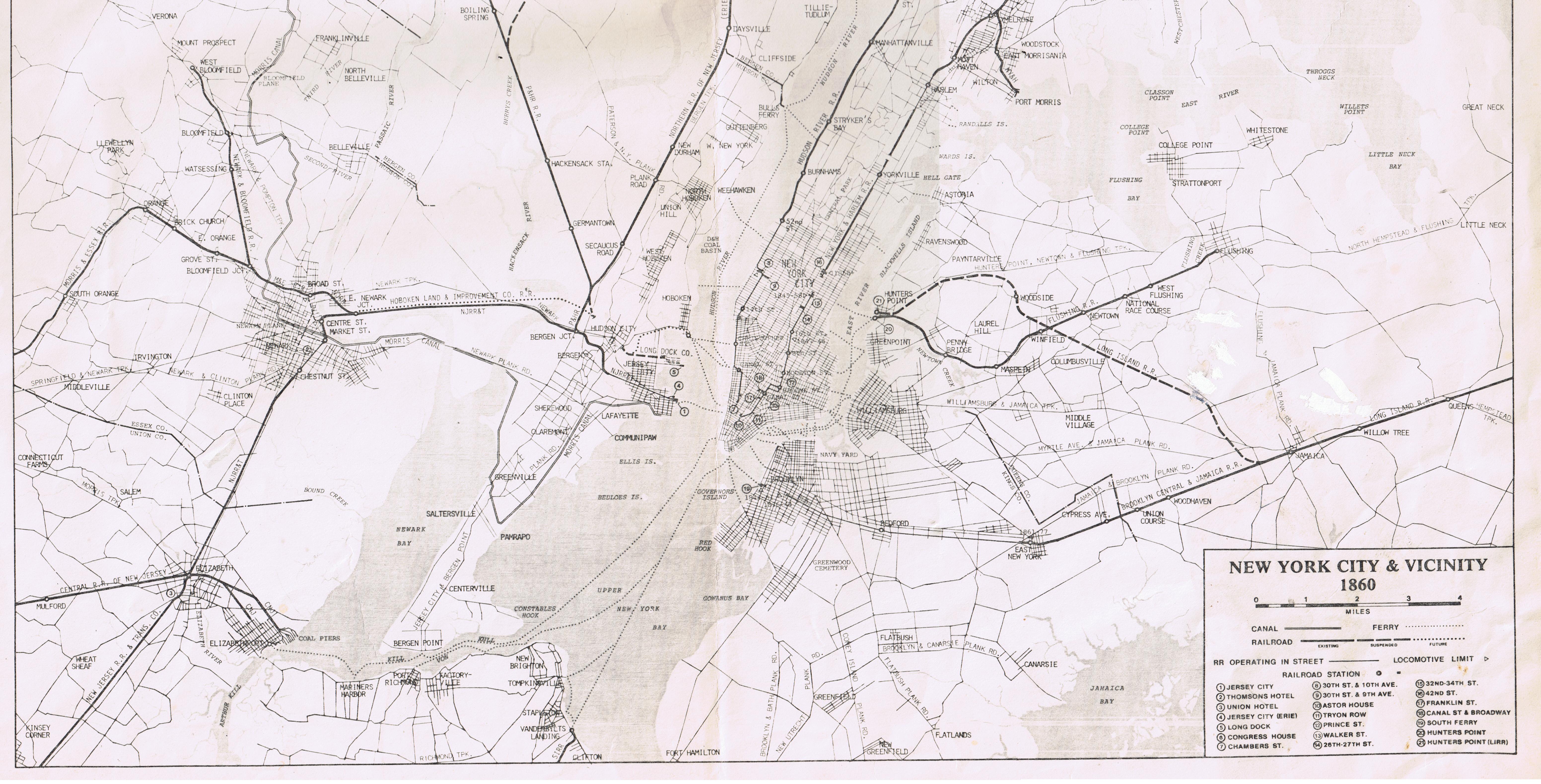
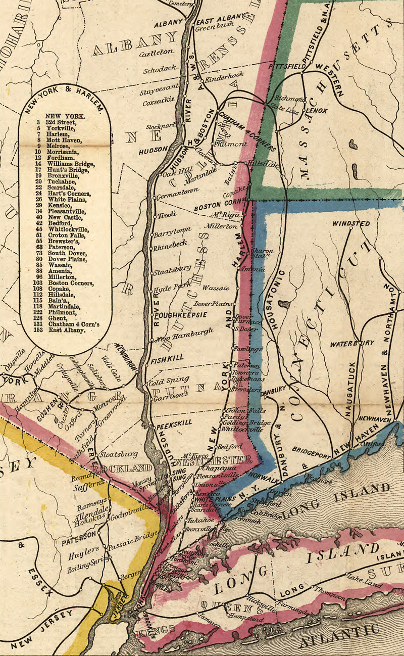
References
[edit]- Dana, William B. (1866). The Merchants' Magazine and Commercial Review, Volume 55. New York City: William B. Dana. Retrieved December 12, 2019.
- Dunbar, Seymour (1915). A History of Travel in America: Being an Outline of the Development in Modes of Travel from Archaic Vehicles of Colonial Times to the Completion of the First Transcontinental Railroad: the Influence of the Indians on the Free Movement and Territorial Unity of the White Race: the Part Played by Travel Methods in the Economic Conquest of the Continent: and Those Related Human Experiences, Changing Social Conditions and Governmental Attitudes which Accompanied the Growth of a National Travel System · Volume 3. Indianapolis, Indiana: Bobbs-Merrill Company. Retrieved May 24, 2020.
- Hyatt, Elijah Clarence (1898). History of the New York & Harlem Railroad. Retrieved May 21, 2020.
External links
[edit]| East of Hudson |  | |
|---|---|---|
| West of Hudson (operated by NJ Transit) | ||
| Non-revenue and Predecessor lines | ||
| Other | ||
Harlem Line
View on GrokipediaOverview
Route and Service Characteristics
The Harlem Line operates as a commuter rail service of the Metro-North Railroad, spanning 82 miles (132 km) from Grand Central Terminal in Midtown Manhattan to Wassaic station in Dutchess County, New York.[9] The route traverses urban, suburban, and rural landscapes, passing through Manhattan, the Bronx, Westchester County, Putnam County, and a portion of Dutchess County.[10] It features 37 active stations, the highest number among Metro-North's main lines, providing access to residential communities, business districts, and recreational areas along the corridor.[10] Electrification extends 53 miles north from Grand Central to Southeast station in Putnam County via 750 V DC third rail, enabling high-frequency electric multiple-unit (EMU) service with M7 cars on this segment.[9] Beyond Southeast, the line transitions to diesel operation using P32AC-DM dual-mode locomotives paired with Shoreliner coaches, covering the remaining 29 miles on non-electrified track.[11] The northern section, particularly from Dover Plains to Wassaic, includes single-track segments with passing sidings, contributing to a more scenic but operationally constrained environment.[10] Weekday service emphasizes rush-hour commuting, with peak periods defined as inbound trains arriving at Grand Central between 6:00 a.m. and 10:00 a.m., and outbound trains departing between 4:00 p.m. and 8:00 p.m., requiring peak-fare tickets.[12] During these times, frequencies reach up to 15 trains per hour on the core electrified portion south of North White Plains, supporting high ridership volumes with a mix of express and local patterns.[13] Express trains typically bypass intermediate stops between Grand Central and White Plains or North White Plains, while locals serve all stations; some peak trains terminate at intermediate points like North White Plains (electric) or Southeast (diesel crossover), with others continuing to Wassaic.[10] Off-peak service operates at lower frequencies, generally every 20–30 minutes on the southern electrified section during midday and evenings, reducing to hourly or biennial headways on the diesel portion north of Southeast.[9] Weekend service mirrors off-peak patterns, with trains every 30–60 minutes throughout the route, and limited late-night options.[14] All Harlem Line trains stop at every station from Harlem–125th Street northward, except where express patterns apply, and the line shares trackage with New Haven Line services south of Woodlawn Junction in the Bronx.[10]Ridership and Operations
The Harlem Line provides commuter rail service from Grand Central Terminal in Manhattan to Wassaic station in Dutchess County, spanning 82 miles with 37 stations. Operations are divided into express, local, and limited-stop patterns, with most trains terminating at intermediate points like North White Plains, Southeast, or Wassaic to optimize capacity. Weekday peak-hour service (arrivals at Grand Central 6–10 a.m. and departures 4–8 p.m.) runs at intervals of 10–15 minutes, delivering 4–6 trains per hour from key suburban stations such as White Plains and Mount Kisco. Off-peak weekday service operates every 20–30 minutes, while weekend schedules provide hourly trains throughout the day. Peak fares apply during rush hours, and bicycles are prohibited on inbound morning peak trains but permitted off-peak with limits.[12] Power systems vary along the route: the line uses 750-volt DC third-rail electrification from Grand Central to Southeast (approximately 53 miles), enabling efficient electric multiple-unit (EMU) operation with M7 cars, which offer seating for 600–1,000 passengers per consist. Beyond Southeast, P32AC-DM dual-mode locomotives, including newly introduced Siemens Charger models, haul push-pull coach consists with Shoreliner cars on the non-electrified northern segment to Wassaic. These diesel services typically operate with 6–8 cars, supporting lower-density ridership in Putnam and Dutchess counties. Maintenance occurs at the Harmon Yard complex near Croton-on-Hudson, with ongoing capital investments targeting signal upgrades and accessibility improvements at stations like Purdy's and Goldens Bridge.[15][16] Ridership on the Harlem Line reflects strong commuter demand, particularly for travel to and from Manhattan. In 2024, the line recorded 20.44 million passenger trips, a 11.6% increase from 18.32 million in 2023, driven by 9.9% growth in monthly commutation tickets and 14.6% in non-commutation ridership. The 2023 figure marked a 22.6% rise from 2022's 14.95 million, signaling accelerated post-pandemic recovery amid hybrid work trends. Fall 2024 average daily ridership reached 19,622 during AM peak hours (up 6.2% from 2023) and 16,706 during PM peak (up 3.2%), with off-peak weekday averages at 18,688 (up 1.0%). Overall, Metro-North's East of Hudson services, including the Harlem Line, achieved 77.8% of 2019 pre-pandemic levels in 2024, underscoring the line's role as a vital corridor for Westchester and beyond.[17][18]Line Description
Manhattan and the Bronx
The Harlem Line begins at Grand Central Terminal in Midtown Manhattan, serving as the southern terminus for all northbound trains and the arrival point for southbound services. From Grand Central, the four-track mainline runs underground through the Park Avenue Tunnel, a historic infrastructure element completed in the 19th century to bypass street-level operations. The tunnel extends north approximately 3 miles before emerging to the surface near 96th Street in the Upper East Side. This section is fully electrified with 750 V DC third rail and supports high-frequency commuter service, with trains sharing the right-of-way with the Metro-North New Haven Line until the split at Woodlawn in the Bronx.[10][12] The first intermediate stop in Manhattan is Harlem–125th Street station, located at the intersection of Park Avenue and East 125th Street in East Harlem. Opened in 1996 as part of efforts to enhance connectivity in upper Manhattan, the station features two island platforms serving the four tracks and provides key transfer opportunities to the New York City Subway's 4, 5, and 6 trains. It handles significant ridership from local commuters. Beyond this station, the line crosses the Harlem River via a swing bridge and enters the Bronx, transitioning from an urban tunnel environment to an open-cut and elevated configuration amid densely populated neighborhoods.[19][10] In the Bronx, the Harlem Line traverses the southwest borough along a predominantly four-track corridor, running parallel to the Major Deegan Expressway (I-87) before curving east near the Cross Bronx Expressway (I-95). Stations include Melrose (near East 162nd Street), an open-cut stop with two side platforms and recent platform renovations; Tremont (near East 177th Street), featuring elevated tracks with crossovers for operational flexibility; and Fordham (at East Fordham Road), a major hub with two island platforms where New Haven Line express trains make limited stops. Further north, Botanical Garden station (adjacent to the New York Botanical Garden) and Williams Bridge (near Gun Hill Road) offer side platform access, with the latter providing connections to the subway's 2 and 5 lines. The line's infrastructure here includes retaining walls and viaducts to navigate the hilly terrain and urban density, with full electrification maintained. As of 2025, major reconstruction and accessibility upgrades, including new elevators, are underway at Williams Bridge, Woodlawn, and Botanical Garden stations to improve ADA compliance.[10][12][20] Continuing through the Bronx, Woodlawn station (near Webster Avenue) marks the divergence point where the New Haven Line branches east toward Westchester County, leaving the Harlem Line on its dedicated two- to four-track path. The final Bronx stop is Wakefield (at East 233rd Street), equipped with two island platforms on three tracks and serving as a transfer point to the subway's 2 line. This segment passes through residential areas of the northeast Bronx, with the tracks elevated in places to cross streets and the Bronx River. The Bronx portion spans about 8 miles, emphasizing local service with all Harlem Line trains stopping at these stations to support daily commuting patterns. Ongoing MTA investments, such as accessibility upgrades at stations like Williams Bridge and Woodlawn, aim to improve capacity and ADA compliance.[10][12]Westchester County
The Harlem Line enters Westchester County immediately north of the Bronx, with the Wakefield station marking the southern boundary as the first stop in the county. From there, the route proceeds northward through densely populated urban and suburban areas, serving stations in Mount Vernon (Mount Vernon West and Fleetwood), Bronxville, Tuckahoe, and Crestwood. The line parallels the Bronx River in its southern segment, facilitating commuter access to midtown Manhattan via electric multiple units on four tracks. This section features frequent local and express services, with many stations dating back to the 19th century but modernized for accessibility and parking.[21] Continuing north, the line reaches the affluent villages of Scarsdale and Hartsdale before arriving at White Plains, the county seat and a major transfer point with bus connections to the Bee-Line system. Beyond White Plains, stations include North White Plains (the northern limit of electrification), Valhalla, Hawthorne, and Pleasantville, where the terrain shifts to rolling hills and residential neighborhoods. The route then passes through Chappaqua and Mount Kisco, known for their upscale communities, before serving Bedford Hills, Katonah, and Croton Falls near the Putnam County line. Throughout Westchester, the 17 stations support over 20 million annual riders, emphasizing the line's role in regional connectivity, though service tapers to diesel-powered trains north of North White Plains for the remaining 30 miles in the county.[21] Key infrastructure highlights include grade separations over major roadways like the Cross County Parkway near Fleetwood and elevated sections through Scarsdale to minimize street-level crossings. The line's double-track configuration allows for bidirectional service, with peak-hour expresses skipping smaller stops to reduce travel time to Grand Central Terminal to under an hour from White Plains. Recent upgrades, such as platform extensions at Hartsdale and Pleasantville, have improved capacity for longer trains amid growing suburban demand.[22]Putnam County
The Harlem Line enters Putnam County immediately north of Croton Falls station, traversing approximately 12 miles of predominantly rural terrain characterized by rolling hills, woodlands, and proximity to the East Branch Croton Reservoir.[23] The segment features double tracks with third-rail electrification until Southeast station, after which it transitions to single-track diesel operation with occasional passing sidings to accommodate northbound service toward Dutchess County.[4] The first station in Putnam County is Brewster at milepost 51.9, serving the village of Brewster and adjacent to Brewster Yard, Metro-North's primary maintenance and servicing facility for diesel locomotives and non-electric rolling stock on the Harlem Line.[24] [25] Just 1.3 miles north lies Southeast station at milepost 53.2, the northern terminus of electrification and a key transfer point for local bus services; it was originally opened as Brewster North in 1980 to support expanded upper-line service.[26] [4] The line then proceeds through more isolated countryside to Patterson station at milepost 60.2, a flag stop in the town of Patterson that primarily serves rural commuters and connects to limited local transit options.[27] [28] This portion of the route, while less densely populated than sections in Manhattan or Westchester County, supports daily express and local trains, with diesel push-pull consists handling the non-electrified stretch to facilitate reliable service for residents accessing employment in New York City.[12] Putnam County's three Harlem Line stations—Brewster, Southeast, and Patterson—collectively handle a modest share of the line's overall ridership, emphasizing regional connectivity over high-volume urban commuting.[28]Dutchess County
The Harlem Line enters Dutchess County from the south, crossing the Putnam County line immediately north of the Southeast station and traversing approximately 21 miles through the rural eastern portion of the county, known as the Harlem Valley. This segment features a single-track, non-electrified diesel-powered route winding through agricultural fields, woodlands, and hilly terrain, with elevations rising gradually toward the northern terminus. The area is dotted with small villages and natural features, including crossings of the Tenmile River and proximity to the Appalachian Mountains, providing scenic views for passengers. Service on this stretch primarily consists of local and semi-express trains connecting to Grand Central Terminal, with frequencies of about 10-12 trains per day in each direction during weekdays, decreasing on weekends.[29][30] The line serves six stations in Dutchess County, all unstaffed side-platform stops equipped with ticket vending machines and basic shelters. These facilities cater to commuters from rural communities, with parking lots accommodating local demand and connections to Dutchess County Public Transit buses for further regional access. Accessibility features, including ramps and tactile warning strips, are available at all stations, though none have full elevator service. The Appalachian Trail station operates as a seasonal flag stop, primarily for hikers accessing the nearby trail.[31]| Station | Location/Town | Key Features | Parking Capacity |
|---|---|---|---|
| Pawling | Pawling | Side platform; audiovisual announcements; ramp access; serves village center with local shops. | 211 spaces[32] |
| Appalachian Trail | Pawling | Flag stop; minimal facilities; open weekends/holidays for trail users; near Route 22 crossing. | None (street parking nearby)[33] |
| Harlem Valley–Wingdale | Dover | Side platform; ramp access; near former Harlem Valley State Hospital site; bus connections available. | 145 spaces[34] |
| Dover Plains | Dover | Side platform; serves Dover Plains village; proximity to Route 22 for local access. | 125 spaces[35] |
| Tenmile River | Amenia | Remote stop; basic shelter; near state border with limited amenities. | 68 spaces[36] |
| Wassaic | Amenia | Northern terminus; side platform; opened in 2000 as extension from Dover Plains; parking lot with bus links to Millerton. | 342 spaces[37] |
History
Origins and Early Extensions (1831–1873)
The New York and Harlem Railroad was chartered by the New York State Legislature on April 25, 1831, with an initial capital stock of $350,000, to construct a railroad from the southern tip of Manhattan to the Harlem River. The incorporators included prominent figures such as Benjamin Baily and Mordecai M. Noah, and the line was envisioned as New York's first railroad, initially planned as a horse-drawn street railway to serve urban and suburban travel. Groundbreaking occurred on February 23, 1832, at Murray Hill, with construction facing challenges like rocky terrain and urban obstacles; the first segment of track, from Prince Street on the Bowery to Fourteenth Street, was completed and opened for horse-drawn service on November 26, 1832.[40] Extensions proceeded incrementally in the 1830s, driven by amendments to the charter. An 1832 amendment allowed the line to run along Fourth Avenue to Fourteenth Street, while service reached Yorkville by summer 1836 and the village of Harlem (near 129th Street) by 1837, marking the completion of the original Manhattan route.[40] A significant 1840 charter amendment authorized northward expansion through Westchester County, enabling the crossing of the Harlem River via a wooden bridge in 1842 to reach Williams Bridge in the Bronx.[5] By March 1, 1841, steam locomotives were introduced on the extension to Fordham, shifting from horse power and accelerating development along the route. Further extensions solidified the line's regional importance by mid-century. The route reached White Plains in 1844, providing vital connections for Westchester residents, and extended to Croton Falls by June 1847, then Dover Plains in 1848.[40] A 1846 legislative authorization pushed the line toward Albany, culminating in its completion to Chatham on May 10, 1852—a total of 130.5 miles from City Hall—where it linked with the Boston and Albany Railroad for through service to New England.[5] Key figures like vice-president John Mason and engineer General Swift oversaw these developments, including land acquisitions by Gouverneur Morris. The period ended with the line's lease to the New York Central and Hudson River Railroad on April 1, 1873, for 401 years, integrating it into a larger network under Cornelius Vanderbilt's growing influence, which began with stock purchases in the 1850s.[40]New York Central Ownership (1873–1968)
On April 1, 1873, the New York and Harlem Railroad leased its lines north of Grand Central Depot to the New York Central and Hudson River Railroad for a term of 401 years, effectively placing the route under New York Central control and designating it as the Harlem Division.[41] This arrangement followed Cornelius Vanderbilt's acquisition of the New York and Harlem in the 1860s, integrating it into his expanding rail empire. Under New York Central ownership, the division primarily served commuter and local freight traffic, with through passenger services extending to Chatham, New York, and connections to the Boston and Albany Railroad for longer hauls to Pittsfield and North Adams.[42] Early operations focused on improving safety and capacity, including the construction of a four-track lowered roadbed and viaducts along the route from Mott Haven Junction northward.[43] Significant infrastructure upgrades occurred in the late 19th century, notably grade separations to eliminate hazardous at-grade crossings. In 1875, the line between Grand Central and the Harlem River was placed in an open cut and viaduct configuration, reducing accidents and enabling faster speeds.[44] These enhancements were part of broader New York Central efforts to modernize urban rail access, culminating in the ambitious Park Avenue improvement project initiated in the 1890s, which depressed tracks and built retaining walls to separate rail from street traffic. By the early 1900s, the division supported growing suburban development in Westchester County, with stations like Scarsdale and White Plains becoming key commuter hubs.[42] The most transformative changes came with the electrification of the Harlem Division, driven by the need to ban steam locomotives from Manhattan amid the construction of Grand Central Terminal (1903–1913). Third-rail electrification commenced in 1907, with the first electric passenger service operating between Grand Central Terminal and Wakefield on January 29, 1907.[45] The system expanded northward to White Plains by 1910, coinciding with the terminal's opening and the full undergrounding of tracks south of 59th Street.[40] Further extensions followed, reaching North White Plains by 1910, allowing electric multiple units to handle peak commuter loads while steam and later diesel locomotives served the northern segments. This electrification, powered at 660 volts DC, marked a pioneering effort in urban rail modernization and boosted ridership, with nearly 50 daily trains to White Plains by 1912.[46] Post-World War II, the New York Central shifted to diesel power on non-electrified sections, ending steam operations in September 1952 to cut maintenance costs amid rising competition from automobiles and highways.[5] Commuter service remained the division's focus, with the main line terminating at Brewster and limited extensions to Pawling or Dover Plains; long-distance runs to Chatham were curtailed to one weekday round-trip and two weekend trains by the late 1960s. Stations like Towners closed in 1967, and infrastructure maintenance declined as financial pressures mounted. The Harlem Division operated under New York Central until February 1, 1968, when the railroad merged with the Pennsylvania Railroad to form Penn Central.[5]Penn Central Decline (1968–1976)
The Penn Central Transportation Company was formed on February 1, 1968, through the merger of the New York Central Railroad and the Pennsylvania Railroad, inheriting the Harlem Division as part of its commuter network serving the New York City metropolitan area.[47] The Harlem Line, running from Grand Central Terminal northward through the Bronx, Westchester, Putnam, and Dutchess counties to Dover Plains and beyond to Chatham, faced immediate challenges under the new entity due to overlapping management structures, deferred maintenance, and rising operational costs amid declining freight and intercity passenger revenues. Commuter service on the line continued with electric multiple units south of Woodlawn and diesel-powered trains on the northern segments, but frequency reductions began as early as 1969 to cut losses, with some rush-hour trains shortened or combined.[48] Penn Central's financial deterioration accelerated, culminating in the largest corporate bankruptcy in U.S. history on June 21, 1970, with debts exceeding $6 billion. The company sought to discontinue unprofitable services, including the Harlem Line's extension north of Dover Plains to Chatham, citing annual losses of approximately $300,000 on that segment alone; this effort was initially rebuffed when Amtrak, formed under the Rail Passenger Service Act of 1970, declined to assume responsibility for commuter operations. In May 1970, Penn Central petitioned the Interstate Commerce Commission (ICC) for permission to end service beyond Dover Plains, arguing that low ridership—fewer than 100 daily passengers—did not justify continued operation. Courts temporarily mandated maintenance of the service amid protests from local groups like the Harlem Valley Transportation Association, but infrastructure neglect persisted, including outdated signaling and rolling stock shortages.[49][50] By 1971, service quality on the Harlem Line had visibly declined, with reports of overcrowded cars, unreliable schedules, and minimal capital investments, as Penn Central prioritized freight recovery over commuter improvements. On July 31, 1971, the railroad announced immediate cessation of all trains to Chatham, prompting emergency ICC approval in early 1972 for permanent discontinuation north of Dover Plains effective March 26, 1972, severing the line's historical connection to Albany. This cut isolated communities in the Upper Harlem Valley, forcing reliance on buses or private autos, and highlighted the broader crisis in Northeast commuter rail. In response, the Metropolitan Transportation Authority (MTA) negotiated a lease for the Harlem and Hudson lines from Grand Central to North White Plains (with ownership extending to Dover Plains), approved by a federal court on May 12, 1972, and effective June 1, 1972; under the 60-year, $1-per-year agreement, Penn Central retained operational duties for an annual fee of $125,000 plus costs, while MTA funded $14 million in new Budd SPV-2000 rail diesel cars and other equipment to stabilize service.[51][52] From 1972 to 1976, Penn Central operated the Harlem Line under MTA subsidy, but bankruptcy proceedings limited improvements, resulting in ongoing issues like a major tunnel fire at Park Avenue in May 1973 that disrupted service and injured 30 passengers due to smoke inhalation. Ridership held steady at around 20,000 daily commuters south of the cuts, supported by subsidized fares, but northern extensions remained abandoned for passengers, with tracks retained for sporadic freight until 1980. The era ended with the Regional Rail Reorganization Act of 1973, which transferred most Penn Central assets to Conrail on April 1, 1976; Conrail assumed operation of the MTA-contracted Harlem Line, marking the close of Penn Central's troubled stewardship.[53]Metro-North Era and MTA Acquisition (1983–present)
On January 1, 1983, the Metropolitan Transportation Authority (MTA) established Metro-North Commuter Railroad as a subsidiary to assume direct operation of commuter rail services on the Harlem, Hudson, and New Haven lines, which had been managed by Conrail under contract since 1976 following the Penn Central merger.[4][54] This transition marked the end of private freight carrier involvement in commuter operations and allowed the MTA to implement unified management, including coordinated railcar procurement with the Long Island Rail Road.[4] Initial challenges included aging infrastructure and equipment, with on-time performance at approximately 80.5%, but Metro-North quickly prioritized safety and reliability enhancements across the system.[4] A major milestone for the Harlem Line was the completion of electrification from North White Plains to Southeast (then known as Brewster North), spanning 29 miles and costing $75 million, with electric service commencing on April 30, 1984.[55][4] This upgrade enabled the use of electric multiple units, reducing travel times and eliminating diesel emissions in that segment, while allowing diesel shuttles to continue north of Southeast.[4] In 2000, the line extended further 5 miles to Wassaic in Dutchess County, adding new stations at Tenmile River and Wassaic to serve growing suburban demand.[4] Service enhancements followed, including the 2004 addition of a third main track between Fleetwood and Crestwood in Westchester County, which supported more express trains, increased frequencies to stations like Bronxville and Tuckahoe, and expanded reverse-peak service.[4] Under MTA oversight, the Harlem Line has seen sustained investments in fleet modernization, with over 800 new railcars acquired since 1983, and operational improvements driving on-time performance above 97% in recent years.[4] Ridership on Metro-North lines, including Harlem, peaked at 86.6 million annual trips pre-pandemic and has recovered to 65-70% of that level by 2023 and 77.8% (approximately 66.3 million trips) by 2024, bolstered by digital tools like the TrainTime app.[4][17] Recent developments include the deployment of new locomotives for enhanced reliability.[56] In 2024, Metro-North achieved record post-pandemic ridership, underscoring the line's role in regional connectivity.[57]Branches
Abandoned Passenger Branches
The Putnam Division, originally constructed by the New York and Putnam Railroad and opened in 1881, served as a key passenger branch diverging from the Harlem Line at Highbridge Junction in the Bronx and extending approximately 35 miles northwest through the Bronx, Westchester County, and Putnam County to Brewster, where it connected with the Harlem Line.[58] Leased to the New York Central Railroad in 1891, with its southern portion electrified in 1926 from Sedgwick Avenue to Van Cortlandt Junction, the line featured several stations, including Sedgwick Avenue, Kingsbridge, Van Cortlandt, and Bedford Hills, catering primarily to suburban commuters and freight alongside passenger operations.[58] By the mid-20th century, declining ridership due to competition from automobiles and buses led to service reductions; a short spur known as the Getty Square Branch in Yonkers, which split from the main Putnam at Lowerre and served stations like Park Hill and Getty Square, had already ended passenger operations in 1943.[58] Full passenger service on the Putnam Division terminated on May 29, 1958, as authorized by the New York Public Service Commission amid the New York Central's financial struggles, though freight continued until the 1980s.[58] To mitigate the impact of the Putnam's closure on northern riders, the New York Central instituted a temporary shuttle service from Mahopac northward, utilizing the connecting Lake Mahopac Branch to reach the Harlem main line at Brewster. The Lake Mahopac Branch, built in 1871 by the New York and Mahopac Railroad as a 7-mile link from Mahopac on the Putnam to Brewster, originally facilitated passenger travel to the lake resort area and included stops at Lake Mahopac and Lincolndale. This shuttle, dubbed "around the horn," operated briefly after the Putnam's main southern segment was severed but proved unsustainable due to low usage. Passenger service on the Lake Mahopac Branch ended on April 2, 1959, marking the complete abandonment of organized passenger operations on both branches, with tracks later removed in segments for freight-only use before full disuse. These abandonments reflected broader postwar trends in U.S. railroading, where branch lines like the Putnam and Lake Mahopac suffered from suburban sprawl and highway expansion, ultimately converting former rail corridors into trails such as the Putnam County Trailway and Harlem Valley Rail Trail.[58]Freight and Industrial Branches
The Harlem Line has supported a limited number of dedicated freight and industrial branches over its history, primarily to serve manufacturing, warehousing, and port-related activities in the Bronx and connections to broader rail networks in the Hudson Valley. These branches were developed in the 19th century as the line expanded northward, with freight operations focusing on commodities like coal, lumber, milk, and manufactured goods rather than long-haul traffic. Unlike the main line's emphasis on passenger service, these spurs and connectors were operated intermittently by successor railroads including the New York Central, Penn Central, Conrail, and Metro-North, often sharing trackage with passenger trains during off-peak hours.[5][8] The most prominent freight branch was the Port Morris Branch, a 1.84-mile (2.96 km) spur diverging southbound from the Harlem Line near Melrose in the South Bronx. Acquired by the New York and Harlem Railroad in 1853 via the purchase of the Spuyten Duyvil and Port Morris Railroad, it provided access to industrial waterfront facilities at Port Morris along the Harlem River, handling inbound coal for gasworks and outbound shipments from factories and breweries. The branch featured tight curves and low clearances, limiting its use to local switching, and remained active under Conrail until the late 1970s. It became redundant after the 1998 opening of the Oak Point Link, which offered a more direct freight route to the Bronx, leading to deactivation and formal abandonment by Metro-North in 2003.[44][59][60] Another key connector was the Beacon Line, a freight-oriented route linking the Harlem Line at Brewster to the Hudson Line at Beacon and extending eastward toward Danbury on the New Haven Line. Originally built in the 19th century as part of the New York, New Haven and Hartford Railroad's network to reach the Maybrook Yard, it facilitated through freight movements across the three Metro-North corridors east of the Hudson River. Conrail used it for overhead traffic until the 1980s, after which activity dwindled; Metro-North acquired the line in 1995 primarily for potential non-revenue uses like equipment storage and occasional excursions. The line has been out of regular service for decades. Metro-North filed for abandonment in 2021, and the MTA officially abandoned the approximately 41-mile segment from Beacon to the Connecticut state line near Brewster in 2024, with plans to repurpose it as the Beacon-Hopewell Rail Trail as of 2025.[61][62][63][64] Shorter industrial spurs have dotted the Harlem Line corridor, particularly in urban sections of the Bronx and Westchester County, serving facilities like lumber yards, propane distributors, and railcar manufacturers. These side tracks, often less than a mile long, supported local economies by enabling direct rail delivery to businesses adjacent to the main line. Metro-North continues limited freight switching from its Croton West Yard, handling a handful of daily carloads to remaining customers, though volumes are low compared to historical peaks due to trucking competition and urban redevelopment.[65]Rolling Stock
Electric Multiple Units
The electric multiple units (EMUs) serve the 53-mile electrified segment of the Harlem Line from Grand Central Terminal to Southeast station, powered by a 750 V DC third rail system that enables self-propelled operation without dedicated locomotives. This configuration supports high-frequency commuter service, with trains accelerating quickly and maintaining efficient energy use along the route's urban and suburban corridors. The EMUs are integral to Metro-North's operations on the line, handling the bulk of peak-hour ridership from Manhattan northward.[15] Metro-North's current EMU fleet for the Harlem Line and other electric services primarily comprises M7A cars, produced by Bombardier Transportation between 2002 and 2007. These single-level railcars offer air conditioning, improved lighting, and partial ADA accessibility, with a design optimized for third-rail power and a maximum speed of 100 mph to facilitate reliable express and local runs. Complementing them are a limited number of M3A cars, manufactured by the Budd Company in 1984 and 1985, which feature stainless steel construction and basic amenities but have exceeded their 40-year useful life, leading to increased maintenance demands.[15] In response to the aging infrastructure, the MTA awarded Alstom a $2.3 billion contract in July 2025 to deliver 156 M9A EMUs dedicated to Metro-North, targeted at phasing out the M3A cars and enhancing overall fleet capacity. These next-generation cars incorporate advanced features including dedicated wheelchair areas, accessible restrooms, USB charging outlets, and dual extra-wide doors per side for expedited boarding, all while meeting stringent cybersecurity requirements. Deployment on the Harlem Line is anticipated to begin in the late 2020s, boosting accessibility, reliability, and passenger experience amid growing demand.[66]Diesel Locomotives and Coaches
The northern segment of the Harlem Line, from Southeast to Wassaic, operates in diesel territory due to the absence of third-rail electrification beyond Southeast station, covering approximately 29 miles of single-track route served primarily by shuttle trains.[55] Diesel-powered push-pull consists are employed for these services, with occasional through trains during peak hours utilizing dual-mode locomotives to transition seamlessly from the electrified southern portion. This setup supports hourly shuttle frequencies, enhancing connectivity for rural stations like Pawling and Harlem Valley–Wassaic.[67] Metro-North primarily deploys General Electric P32AC-DM dual-mode locomotives for diesel operations on the Harlem Line, a fleet of 31 units built between 1994 and 1997, each producing 3,200 horsepower in diesel mode and capable of 110 mph top speed. These B-B wheel arrangement locomotives feature a unique electro-diesel design, allowing third-rail operation in electric mode south of Southeast while switching to diesel power for the northern extension, thereby eliminating the need for locomotive changes at the electrification boundary. Several P32AC-DMs have been rebranded in the railroad's Heritage Series, with wraps commemorating historical liveries from predecessors like the New York Central, applied to units such as No. 208 in 2023 and No. 201 in 2023, to celebrate Metro-North's 40 years of service; these wrapped units regularly appear on Harlem Line diesel runs.[11][68] For shorter shuttle services, Metro-North utilizes Brookville BL20-GH diesel locomotives, a fleet of twelve 2,000-horsepower units acquired in 2008 specifically for non-electrified branches including the Harlem Line's northern end (six owned by Metro-North, numbered 110–115; six by Connecticut Department of Transportation, numbered 125–130). These four-axle, low-emissions locomotives, designed for push-pull operation, provide reliable power for the low-density shuttle with a top speed of 110 mph, often paired with cab control cars to facilitate efficient turns at Wassaic. The BL20-GHs emphasize fuel efficiency and reduced maintenance, aligning with Metro-North's sustainability goals for diesel fleets.[69][11] Passenger coaches on Harlem Line diesel trains consist mainly of Bombardier Shoreliner single-level cars, introduced in the 1980s and numbering over 200 across variants I through V, with capacities of 139–160 seats per car in configurations including gallery-style seating for commuter comfort. These stainless-steel coaches, equipped with HVAC systems and accessible features like wheelchair lifts, operate in push-pull mode with locomotives at one end and cab cars at the other, enabling bi-directional running without turning. Shoreliner III and IV models, featuring improved interiors with LED lighting and USB ports in recent refurbishments, form typical three- to four-car shuttles, supporting the line's focus on reliable regional service while plans include replacement with 60 new single-level cars from Alstom, approved in August 2023, to boost capacity and accessibility.[69]Stations
Main Line Stations
The Harlem Line's main line comprises 37 stations extending approximately 82 miles from Grand Central Terminal in Midtown Manhattan to Wassaic station in Dutchess County, New York, serving urban, suburban, and rural communities across four counties.[12] This configuration positions the Harlem Line as Metro-North's longest route by number of stops, facilitating daily commutes for over 20 million passengers annually as of 2024, with ridership reaching 20.44 million trips—a 11.6% increase from 2023.[17] Electrified service operates from Grand Central to North White Plains using third-rail power, while diesel locomotives power trains north of there to the terminus.[3] Many stations feature modern amenities, including ticket vending machines, waiting areas, and connections to local buses, with ongoing MTA investments enhancing accessibility under the Americans with Disabilities Act (ADA). The stations can be grouped geographically, reflecting the line's progression from dense city neighborhoods to affluent suburbs and exurban areas. In Manhattan and the Bronx, stops emphasize intermodal connectivity and high-volume urban ridership. Harlem–125th Street, located at East 125th Street in East Harlem, serves as the second station northbound and functions as a major hub with direct subway links to the 4, 5, and 6 trains; it includes full ADA accessibility with elevators and is part of planned expansions for high-speed rail connections. Bronx stations like Fordham, situated near Fordham University and the Bronx Zoo, offer transfers to the New Haven Line and see significant intermediate traffic, with renovated platforms and elevators completed in recent years. Woodlawn provides access to Woodlawn Cemetery, a historic site, and features parking for 200 vehicles alongside bus connections.[70] Transitioning into Westchester County, the line's stations support commuter patterns to and from Manhattan, with White Plains emerging as a pivotal midpoint. White Plains station, at 1 Railroad Plaza, is fully accessible with elevators to all platforms, offers 1,000 parking spaces, and connects to Bee-Line buses and the Westchester County Center; a $95 million renovation completed in 2021 added safety upgrades, expanded waiting areas, and artwork installations. Nearby, Scarsdale and Hartsdale cater to residential enclaves, each with partial accessibility and limited parking, emphasizing pedestrian access to upscale neighborhoods. North White Plains marks the electrification endpoint, with layover tracks for electric multiple units and bus interchanges.[71] North of North White Plains, stations in northern Westchester, Putnam, and Dutchess counties shift toward longer-distance and recreational travel, with diesel service accommodating fewer but more spread-out stops. Brewster, at 3 Station Place in Putnam County, serves as the junction for the Danbury Branch and includes 300 parking spots, full accessibility via ramps, and proximity to I-84 for regional access. Southeast station, adjacent to the Metro-North I-84 parking lot with over 1,200 spaces, supports park-and-ride commuters and features recent platform reconstructions for improved safety. The northernmost stations, such as Pawling and Wassaic, reflect rural character: Pawling offers trail connections to the Appalachian Trail and limited parking, while the Appalachian Trail station (limited service on weekends and holidays) provides direct access for hikers; Wassaic, the line's terminus since extension in 2000, provides 150 parking spaces, basic shelters, and links to local shuttles for hikers and visitors to the Harlem Valley. Overall, these stations underscore the line's role in regional connectivity, with infrastructure upgrades like positive train control and station rehabilitations ongoing to boost capacity and reliability.[3]| Station Name | Location (County) | Distance from Grand Central (miles) | Fare Zone |
|---|---|---|---|
| Grand Central | Manhattan | 0 | 1 |
| Harlem–125th Street | Manhattan | 4 | 1 |
| Melrose | Bronx | 6 | 2 |
| Tremont | Bronx | 8 | 2 |
| Fordham | Bronx | 9 | 2 |
| Botanical Garden | Bronx | 10 | 2 |
| Williams Bridge | Bronx | 11 | 2 |
| Woodlawn | Bronx | 12 | 2 |
| Wakefield | Bronx | 13 | 2 |
| Mount Vernon West | Westchester | 13 | 2 |
| Fleetwood | Westchester | 14 | 2 |
| Bronxville | Westchester | 15 | 2 |
| Tuckahoe | Westchester | 16 | 2 |
| Crestwood | Westchester | 17 | 2 |
| Scarsdale | Westchester | 19 | 2 |
| Hartsdale | Westchester | 21 | 3 |
| White Plains | Westchester | 22 | 3 |
| North White Plains | Westchester | 24 | 3 |
| Valhalla | Westchester | 26 | 3 |
| Hawthorne | Westchester | 28 | 3 |
| Pleasantville | Westchester | 31 | 3 |
| Chappaqua | Westchester | 32 | 3 |
| Mount Kisco | Westchester | 37 | 3 |
| Bedford Hills | Westchester | 39 | 3 |
| Katonah | Westchester | 41 | 3 |
| Goldens Bridge | Westchester | 44 | 3 |
| Purdy's | Westchester | 46 | 3 |
| Croton Falls | Westchester | 48 | 3 |
| Brewster | Putnam | 52 | 4 |
| Southeast | Putnam | 53 | 4 |
| Patterson | Putnam | 60 | 4 |
| Pawling | Dutchess | 64 | 4 |
| Appalachian Trail | Dutchess | 66 | 4 |
| Harlem Valley–Wingdale | Dutchess | 69 | 4 |
| Dover Plains | Dutchess | 77 | 4 |
| Tenmile River | Dutchess | 80 | 4 |
| Wassaic | Dutchess | 82 | 4 |