._Also_Memorial_to_Cape_Mounted_Riflemen_&_Volunteers,_East_Griqualand._1899_-1902._03.jpg/250px-Kokstad_City_Hall_and_Victorian_Bandstand._(Cast_Iron)._Also_Memorial_to_Cape_Mounted_Riflemen_&_Volunteers,_East_Griqualand._1899_-1902._03.jpg "Kokstad")
._Also_Memorial_to_Cape_Mounted_Riflemen_&_Volunteers,_East_Griqualand._1899_-1902._03.jpg/2000px-Kokstad_City_Hall_and_Victorian_Bandstand._(Cast_Iron)._Also_Memorial_to_Cape_Mounted_Riflemen_&_Volunteers,_East_Griqualand._1899_-1902._03.jpg)
Community hub
Recent from talks
Contribute something
Nothing was collected or created yet.
Kokstad
View on WikipediaKokstad is a town in the Harry Gwala District Municipality of the KwaZulu-Natal Province, South Africa. Kokstad is named after the Griqua chief Adam Kok III who settled here in 1863. Kokstad is the capital town of the East Griqualand region, as it is also the biggest town in this region. It was built around Mount Currie, a local mountain range, by the town’s founder Adam Kok III, for whom the town is named. Stad is the Dutch and Afrikaans word for "city".
Key Information
._Also_Memorial_to_Cape_Mounted_Riflemen_%26_Volunteers,_East_Griqualand._1899_-1902._03.jpg)


The town is built on the outer slopes of the Drakensberg and is 1,302 m above sea level. Behind it Mount Currie rises to a height of 2,224 m.
It is a centre for cheese and other dairy products.
Kokstad has the N2 Highway south of the town's CBD. The R56 leads from Kokstad to Cedarville (45 km), Matatiele (68 km) and Maluti leading to the border of Lesotho. The R617 is also a bisecting route leading from Kokstad to Underberg (109 km), Swartberg (41 km) and Bulwer (147 km).
The N2, the national route, leads from Kokstad to the east to Port Shepstone (175 km), Durban (380 km) and to the south Mount Ayliff (57 km), Mthatha (180 km), East London (419 km) and Qonce (447 km).
Kokstad is 10 km from the Eastern Cape border on the N2.
The majority of residents can speak IsiXhosa as well as IsiZulu.
Kokstad has no rural villages to date. It is a farming community with majority of its countryside land being cattle farms or residential farms.
History
[edit]In 1820 the Griqua tribe which lived in Griquatown (in central South Africa) split and under the leadership of Adam Kok III, descendant of the former cook who established the tribe, one section first moved to Philippolis (southern Free State). In 1861 several hundred Griquas moved across the Drakensberg down the Ongeluks Nek to the vicinity of modern Kokstad. They moved because of the growing confrontation they faced with the Voortrekkers who had moved north of the Orange River to escape the laws of the British. The Voortrekkers, largely Dutch, secured leases over Griqua land and then refused to return the land at the end of the lease. The Big Hole of Kimberley was at the centre of controversy over one such lease.
The Griquas were forced to travel over the Drakensberg into a region earlier devastated by the great Zulu King, Shaka—thus its name "Nomansland". By the time the Griquas arrived in their new promised land eighteen months later they were exhausted and most of their livestock had perished. The impoverished Griquas named the mountain where they settled Mount Currie after Sir Walter Currie who gave support to their effort to settle here. Once settled their leader, Adam Kok, renamed their new land East Griqualand. Every male Griqua who settled in East Griqualand was able to secure a 3,000 acres (1,200 ha) farm, but most of them sold their land cheaply to white settlers and squandered their money. The Rev William Dower in his 1902 book The Early Annals of Kokstad describes in great detail how cheaply the Griqua gave their farms away.[2]

When, in 1869, the Reverend William Dower was asked by the Griqua to establish a mission, he agreed on condition that they resettle in a more suitable place on the banks of the Mzimhlava river.
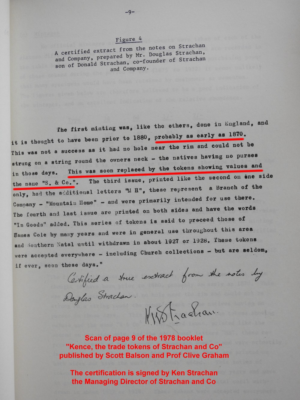
Two prominent European settlers George Brisley and Donald Strachan played a major role in the early development of Kokstad and East Griqualand: their trading store, Strachan and Co, in 1874 introduced South Africa's first indigenous currency—a set of trade tokens which circulated across a wide region, covering an area the size of Ireland.
Confirmation that the Strachan and Co coins circulated as money in the region at this time comes from the local Standard Bank at Kokstad [3] and the managing director of Strachan and Co.[4]
In 1878 East Griqualand came into the possession of Cape Colony. The first hotel in Kokstad, The Royal, was opened by an African-American who also started a newspaper (the Kokstad Advertiser) in 1881. Kokstad became a municipality in 1892. In 1904 the population was recorded at 2903 whom a third were Griquas. The town was transferred to Natal province in 1978. Today the population of Kokstad lies at just over 50,000 people.[5]
Cultural assets
[edit]Stemming from a relatively old farming community, Kokstad rose from the lands beneath Mount Currie. Many old buildings and monuments have been erected that are now considered to be National Heritage Sites.
- The Adam Kok Monument (Griqua): The monument commemorates the leadership of the Griqua, Adam Kok, who, after leading the Griquas from the Southern Free State to Griqualand East during the 1860s, died after a fall off a cart in 1875. The monument is situated next to the police station of Kokstad.[6]
- Kokstad Bandstand (British Colonial): The ornamental, cast iron bandstand dates from 1912. It was donated to the town council by the engineers who were responsible for the Kokstad water scheme. It was declared a national monument in October 1983.[7]
- Boy Scouts Monument (British Monument): The monument to former Boy Scouts who fell in the world wars is situated in the foothills of Mount Currie North of Kokstad.[8]
- Cape Mounted Rifles Monument (British Colonial): The monumen is a tall column surrounded by four lions peering upwards. It is situated close to the town hall.[9]
- St. Patrick's Catholic Church (Cathedral)
- East Griqualand Museum and Community Tourism Info Center: Griqua history is the main theme of this museum's display. Although it has several other local history exhibits and items also known as the Kokstad museum.[10]
- Old town hall (historical building): The old town hall is considered a National Monument Site. It is one of the largest town structures that predates World War I within the surrounding areas. Currently used for ceremonial practices, it also functioned as the town's library for many years until 2005, when the new library on the neighbouring plot was opened. The town hall is now used for many municipal and political functions, as well as public gatherings ranging from weddings to sporting ceremonies.[11]
Attractions
[edit]The area is popular for its many rivers and dams that provide ample opportunity for trout fishing and hiking possibilities. There are three reserves, Mount Currie, Wilfred Bauer and the Mountain Lake Nature Reserve.[12] These have camping and picnic spots. Among these reserves, the Mountain Lake Nature Reserve contains paths that provide sightseeing walks, as well as over 220 species of birds.[13] The Mount Currie reserve is filled with history. On the site stands a historic laager site surrounded by graves of early pioneers and a monument pays homage to Boy Scouts who died during the First World War in East Africa.
The area's many dams provide multiple forms of use. Crystal Springs Dam provides many boating and angling opportunities. The dam is fed by the pure water of Crystal Springs, the main source of Kokstad's water supply. In 1924, William Mortimer Mail (b. 16 November 1885) was to take-up an appointment as the Kokstad Town Engineer, Arguably, Mail's most notable achievement was improvement to Kokstad's drinking water, which at the time of his arrival, was drawn from a mountain stream. Whenever it rained, it became heavily stained. After identifying a suitable spring further down the mountain (Crystal Springs), he first conducted a series of water flow rate metering, to establish there was sufficient flow to meet the town's needs. Once it had been proven there was sufficient flow, Mail then oversaw design and construction of a new water treatment plant. The new plant provided crystal clear water to Kokstad, which helped the town grow and flourish.
In addition to supplying drinking water to the town, the Crystal Spring Dam has become an attraction for both the Kokstad residents, and tourists to the area. There are three rural schemes located in nearby Swartberg, Franklin and Kransdraai, which meet the RDP level of service.[14]
Infrastructure
[edit]Education
[edit]Kokstad has many primary and secondary schools, as well as a tertiary institution college. Some of the main schooling institutions are as follows:
- Carl Malcomess High
- Mount Currie Senior Secondary School
- Seven Fountains Primary School
- Shayamoya High
- Kokstad Public Primary
- Kokstad Junior School[15]
- Kokstad Primary School
- Kokstad College[16]
- St. Patricks College (both primary and secondary)[17]
- Esayidi TVET College[18]
Healthcare
[edit]Public healthcare
[edit]East Griqualand & Usher Memorial Hospital is a 210-bed district public hospital situated north-west of the Kokstad CBD, along the R56 towards Matatiele. It mainly serves Kokstad and surrounding rural communities within the Greater Kokstad Local Municipality (such as Franklin and Swartberg), the neighbouring uMzimkhulu Local Municipality, nearby rural communities in the Eastern Cape Province such as Mount Ayliff, Ntabankulu, Mount Frere as well as the neighbouring country of Lesotho.[19]
Private healthcare
[edit]Kokstad Private Hospital is the main private healthcare facility serving Kokstad, surrounding Southern KZN communities such as Harding, Umzimkhulu and Underberg as well as proximate Eastern Cape communities. Affiliated under the Netcare Group, one of South Africa’s largest private healthcare providers, it offers 24-hour emergency services. Conveniently situated on Barker Street, it lies in the heart of the Kokstad CBD.[20][21]
Coats of arms
[edit]Municipal (1)
[edit]By 1931, the Kokstad municipal council had assumed a pseudo-heraldic "coat of arms" depicting a landscape with Mount Currie in the background, ears of wheat, and a tree, and the motto Concilio et animis.[22]
Municipal (2)
[edit]A proper coat of arms was designed by Ivan Mitford-Barberton in the late 1950s. It was registered with the Cape Provincial Administration in October 1960[23] and at the Bureau of Heraldry in July 1979.
The arms were : Per fess Gules and Or, in chief, dexter a Griqua hunter statant holding in his dexter hand a slain buck and in his sinister hand a rifle, sinister a lion statant, all Or; in base, below a yoke the barrel of a cannon palewise, all Sable; the whole within a bordure compony of 40 pieces Argent and Sable. In layman's terms, the shield was divided horizontally into red and gold, the upper half depicting a Griqua hunter holding a slain buck and a rifle and facing a lion, and the lower half a yoke above an upright black cannon barrel, the whole design surrounded by a border divided into forty sections alternately silver and black.
The crest was a cock's head issuing from a golden eastern crown, and the motto was Pro rege lege et grege.
Literature
[edit]- Alan George Sumner Gibson: Eight Years in Kaffraria, 1882–1890. Wells Gardner, Darton & Co. 1891. Reprinted by Negro University Press, New York City 1969, ISBN 978-0-8371-1573-3.
Notable people associated with Kokstad
[edit]- Ebbo Bastard, South Africa national rugby union team player
- Robert Dower, cricketer
- Trevor Fancutt, tennis player
- Rosa Hope, artist
- Khaya Majola, rugby union player
- Ivan Mitford-Barberton
- Dick Muir, rugby union player
- Wilfrid Napier, Roman Catholic cardinal
- Njongonkulu Ndungane, Anglican Bishop of Kimberley, Kuruman and Archbishop of Cape Town.
- Kelly Seymour, cricketer
- Zanele Situ, paralympian athlete
- Sir Walter Stanford, colonial-era magistrate
References
[edit]- ^ a b c d "Main Place Kokstad". Census 2011.
- ^ Dower, William (1902). The Early Annals of Kokstad and Griqualand East. Port Elizabeth: Kemsley.
- ^ "Standard Bank 125th Anniversary brochure in PDF form - see 2nd page" (PDF). Retrieved 2014-06-17.
- ^ "Ken Strachan Managing Director of Strachan and Co confirm date of 1874". Retrieved 2014-06-17.
- ^ "Census 2011 — Main Place "Kokstad"". Census2011.adrianfrith.com. Retrieved 2015-10-16.
- ^ "Adam Hoek, Historical Religious Cultural Assets - Tourism KwaZulu-Natal". Zulu.org.za. Retrieved 2015-10-16.
- ^ "Bandstand, Historical Religious Cultural Assets - Tourism KwaZulu-Natal". Zulu.org.za. Retrieved 2015-10-16.
- ^ "Boy Scouts Monument, Historical Religious Cultural Assets - Tourism KwaZulu-Natal". Zulu.org.za. Retrieved 2015-10-16.
- ^ "Cape Mounted Rifles Monument, Historical Religious Cultural Assets - Tourism KwaZulu-Natal". Zulu.org.za. Retrieved 2015-10-16.
- ^ "East Griqualand Museum And Community Tourism Info Center, Historical Religious Cultural Assets - Tourism KwaZulu-Natal". Zulu.org.za. Retrieved 2015-10-16.
- ^ "East Griqualand - Historical, Religious & Cultural Assets - Tourism KwaZulu-Natal". Zulu.org.za. Retrieved 2015-10-16.
- ^ "Out & About Attractions / Explore: Crystal Springs Dam, Chapel, Mount Currie", Greater Kokstad Municipality, archived from the original on 22 November 2013
- ^ "Mount Currie Nature Reserve". Sa-venues.com. Retrieved 2015-10-16.
- ^ "Kokstad". Sa-venues.com. Retrieved 2015-10-16.
- ^ "Home". Kokstadjuniorschool.co.za. Retrieved 2015-10-16.
- ^ "Kokstad College". Kokstad College. Retrieved 2015-10-16.
- ^ "St Patrick's College". Stpatrickscollege.co.za. Retrieved 2015-10-16.
- ^ "Home Page | Esayidi TVET".
- ^ "E.G.Usher Memorial Hospital". Kznhealth.gov.za. 2015-05-20. Retrieved 2015-10-16.
- ^ "Home". Kokstad Private Hospital. Archived from the original on 2015-11-25. Retrieved 2015-10-16.
- ^ "Netcare Kokstad Private Hospital". www.netcare.co.za. Archived from the original on 2025-07-16. Retrieved 2025-12-01.
- ^ The arms were depicted on a title=Category:UTC_South_African_town_arms cigarette card issued in 1931.
- ^ Cape of Good Hope Official Gazette 3052 (28 October 1960).
External links
[edit]Municipalities and communities of Harry Gwala District Municipality, KwaZulu-Natal | ||
|---|---|---|
District seat: Stuartstown (Ixopo) | ||
| Nkosazana Dlamini-Zuma | .svg) | |
| Greater Kokstad | ||
| Johannes Phumani Phungula |
| |
| Umzimkhulu | ||
| International | |
|---|---|
| National | |
| Geographic | |
| Other | |
Kokstad
View on GrokipediaKokstad is a town in South Africa's KwaZulu-Natal province, serving as the administrative seat of the Greater Kokstad Local Municipality within the Harry Gwala District, and originally founded in 1872 by the Griqua leader Adam Kok III as the capital of the independent territory of Griqualand East.[1][2] The Griqua, a mixed-heritage people who migrated from the Cape Colony interior due to conflicts with Boer settlers, established the settlement on the outer slopes of the Drakensberg mountains after crossing the range in 1862, naming it in honor of their chief who died shortly after its formalization.[1][2] Annexed by the British Cape Colony in 1877, the town transitioned from Griqua self-governance to colonial administration, preserving its historical significance through sites like the Adam Kok III grave and local museums.[2] At an elevation of 1,302 metres (4,272 ft) beneath Mount Currie, Kokstad's landscape supports extensive stock farming, with the surrounding Greater Kokstad area encompassing approximately 81,700 residents as of 2022.[3][4] The economy centers on agriculture, including cattle rearing and dairy production, supplemented by tourism drawn to the region's natural scenery, hiking opportunities, and cultural heritage tied to its Griqua origins.[5][6] As a gateway between KwaZulu-Natal and the Eastern Cape, it functions as a commercial hub for nearby rural communities, with potential growth in agri-tourism and manufacturing.[5]
Geography
Location and Topography
Kokstad is situated in the Harry Gwala District Municipality of KwaZulu-Natal province, South Africa, near the border with the Eastern Cape. The town lies at geographic coordinates approximately 30°33′S 29°25′E.[7] It serves as the administrative seat of the Greater Kokstad Local Municipality, encompassing an area characterized by its position in the East Griqualand region. The topography of Kokstad features undulating terrain on the outer foothills of the Drakensberg mountain range. The town itself is positioned at an elevation of about 1,300 meters above sea level, with surrounding landscapes dominated by rolling hills and elevated plateaus suitable for pastoral agriculture.[8] Prominent in the local topography is Mount Currie, which rises to 2,224 meters just north of the town center, forming part of the Drakensberg escarpment. This mountainous backdrop contributes to a varied relief, with steeper slopes transitioning to gentler valleys, influencing local microclimates and land use patterns centered on livestock farming.[9] The region's rugged features also support ecotourism and provide natural barriers that have historically shaped settlement patterns.[10]Climate and Environment
Kokstad features a temperate oceanic climate (Cfb in the Köppen classification), influenced by its elevation of approximately 1,300 meters above sea level, resulting in mild summers and cool, frosty winters with occasional snow. Average daily high temperatures range from 17°C in July to 24°C in February, while lows typically fall to 3–4°C during the coldest months of June and July.[11][8] Humidity remains moderate year-round, with muggy conditions rare (averaging fewer than 5 days annually), and winds peak at around 13 km/h in September.[8] Precipitation totals approximately 987 mm annually, concentrated in the summer wet season from October to March, when over 70% of rainfall occurs; December is the wettest month with about 170 mm and 20 days of precipitation exceeding 1 mm. Winters are drier, with June recording the fewest wet days (around 2) and minimal rainfall of 18 mm. The region experiences mostly clear skies throughout the year, supporting a growing season of nearly 10 months.[8] The surrounding environment consists of rolling hills and grasslands in the East Griqualand region, bordering the Drakensberg escarpment, with natural features including rocky crags, wetlands, and protea woodlands. Mount Currie Nature Reserve, 4 km north of the town and spanning altitudes from 1,430 m to 2,224 m, serves as a key protected area for biodiversity conservation, encompassing open grasslands, montane scrub forests, and rehabilitated habitats that support endemics like Dierama tysonii and Erica tysonii. Fauna includes threatened species such as oribi (Ourebia ourebi), African grass owl (Tyto capensis), and bush blackcap (Sylvia nigricapalis), alongside mammals like African wild cat and striped weasel; the reserve also functions as a vital water catchment with an annual rainfall of about 693 mm and regular frost. Invasive plants like wattle pose ongoing threats to native ecology.[9][12]History
Griqua Foundation and Early Settlement (1863–1880s)
In 1862–1863, Adam Kok III (1811–1875), kaptein of the Griqua people from Philippolis, led several hundred followers on an overland trek across the Drakensberg mountains into No Man's Land—a depopulated region east of Basutoland and west of Pondoland, ravaged by earlier Mfecane wars—establishing a new settlement at the base of a prominent peak they named Mount Currie in honor of Sir Walter Currie, a Cape official who had aided their migration.[13][14] This move was prompted by land sales forced upon the Griquas in Philippolis amid Boer encroachments and missionary pressures, with the group comprising mostly mixed-descent pastoralists seeking autonomy.[15] The initial camp, known as De Laager, served as a fortified wagon enclosure that evolved into the core of what became Kokstad, with the Griquas formally taking possession of the surrounding territory in 1863.[16][17] The Griquas rapidly organized a semi-autonomous polity, adopting a constitution, codified laws, and a council-based governance structure under Kok's leadership, which included revenue generation via taxes on trade licenses, fines, and livestock duties to fund public works.[18] They allocated urban stands in the emerging town for Griqua citizens and pursued agriculture, herding, and commerce, including beneficial trading ties with neighboring Pondo chiefdoms that predated the settlement.[16] By the early 1870s, communal efforts had laid out streets, constructed a church, and established a school, with annual voluntary contributions of £500–£600 supporting a resident minister and education—reflecting the Griquas' emphasis on Protestant institutions inherited from London Missionary Society influences.[19] Through the 1870s, the settlement expanded modestly as a Griqua stronghold, with Kokstad formally surveyed and proclaimed a town in 1872, though internal leadership stability waned after Kok's death in 1875, exacerbating pressures from European traders and farmers seeking land grants.[2] The Griquas maintained nominal sovereignty until British diplomatic overtures intensified in the late 1870s, but early development remained centered on self-reliant community building amid sparse European influx.[20]British Annexation and Colonial Development (1880s–1910)
In 1879, amid pressures from neighboring colonies and internal instability following the death of Griqua leader Adam Kok III in 1875, the Cape Colony annexed Griqualand East, including Kokstad as its administrative center. The Cape Parliament passed the Annexation Bill on August 5, 1879, with implementation occurring on October 18, 1880, integrating the territory into the Cape as the districts of Kokstad, Umzimkulu, and Matatiele.[21] This move ended Griqua semi-independence, subordinating their raad (council) to British authority and compelling the population—primarily Griquas, with smaller numbers of Europeans and Africans—to accept Cape governance, including taxation and legal codes that eroded traditional land rights.[22] Under colonial administration, a British magistrate was installed in Kokstad to oversee law enforcement and dispute resolution, shifting power from Griqua captains to Cape officials and prompting resistance from local leaders who viewed the annexation as an infringement on their sovereignty. European influence grew as traders, previously operating under Griqua tolerance, expanded operations; partnerships like that of George Brisley and Donald Strachan, established in 1874, formalized stores and credit systems that integrated the local economy into broader Cape markets, dealing in wool, hides, and grain.[23] Griquas maintained some communal institutions, voluntarily funding religious and educational efforts at £500–£600 annually through their own minister and schoolmaster, though British policies increasingly favored individual land titles for Europeans, leading to farm sales and white settler influx.[19] By the 1890s, Kokstad developed as a regional hub with basic infrastructure, including roads linking to Natal and the Cape, supporting agricultural exports like timber from local sawmills and livestock farming on alienated lands. The period saw modest population growth, with a post-annexation census recording around 4,000 Griquas alongside emerging European communities, though economic benefits skewed toward settlers amid Griqua marginalization.[21] This colonial framework persisted until 1910, when Griqualand East's incorporation into the Union of South Africa solidified Cape-era administrative divisions.[22] 
Following the formation of the Union of South Africa on May 31, 1910, Kokstad and the surrounding East Griqualand region, which had been transferred from the Cape Colony to the Natal Colony in 1904, fell under the provincial administration of Natal within the new dominion.[24] The town maintained its role as a rural administrative and agricultural hub, with economic activity centered on livestock farming, particularly cattle and sheep, supported by European settler farmers who had acquired land through colonial grants and purchases in the late 19th century.[25] Population growth remained modest, with the 1911 census recording approximately 5,000 residents in the Kokstad district, comprising a mix of white farmers, Griqua (classified as Coloured under emerging racial policies), and black laborers primarily of Xhosa and Zulu descent employed on farms. The implementation of apartheid policies after the National Party's victory in 1948 profoundly shaped Kokstad's social and spatial structure. Under the Population Registration Act of 1950, residents of Griqua descent were officially classified as Coloured, subsuming their distinct ethnic identity into a broader category that denied recognition of Griqua autonomy and facilitated land dispossession through mechanisms like the Group Areas Act of 1950, which designated urban and peri-urban areas for white occupation while relocating non-whites to peripheral townships.[25] [26] In East Griqualand, this entrenched white control over prime farmland, reducing Griqua and black access to arable land and exacerbating rural poverty; by the 1960s, much of the region's better agricultural holdings were consolidated under white ownership, with non-white labor systems relying on influx controls that restricted movement under the Natives (Urban Areas) Act amendments.[24] Economic reliance on dairy and wool production persisted, but segregation limited black and Coloured participation in skilled trades, confining them to low-wage farm work or domestic service. In the late apartheid era, Kokstad experienced administrative upheaval as part of broader homeland policies. In 1981, the town and parts of East Griqualand were incorporated into the nominally independent Transkei bantustan, established for Xhosa-speakers under the 1976 independence grant, to consolidate fragmented territories and remove black spots from "white" South Africa; this shift aimed to offload administrative burdens but resulted in underfunded infrastructure and heightened ethnic tensions between local Griqua/Coloured communities and Xhosa migrants.[25] Transkei governance under Chief Kaiser Matanzima imposed additional controls on land use, prioritizing subsistence farming in reserves while white farms outside the homeland boundaries benefited from state subsidies. Political resistance was muted compared to urban centers, though sporadic protests against pass laws and forced removals occurred, aligning with broader anti-apartheid networks like the United Democratic Movement's precursors among Coloured communities.[27] The transition to democracy unfolded with national negotiations from 1990 onward, culminating in South Africa's first multiracial elections on April 27, 1994. Kokstad's reintegration into the Republic as part of the newly formed KwaZulu-Natal province dismantled homeland boundaries, restoring unified administration but exposing disparities in service delivery inherited from apartheid-era neglect. Voter turnout in the district exceeded 80%, reflecting relief from influx controls and optimism for land restitution, though Griqua claims to pre-colonial territories persisted amid unfulfilled promises of equitable reform.[26] This period marked the end of formal racial segregation, with the abolition of the Transkei homeland enabling freer movement and economic integration, albeit with ongoing challenges from fragmented land tenure.[25]Post-Apartheid Era and Modern Challenges (1994–Present)
Following the end of apartheid in 1994, Kokstad was integrated into the newly formed KwaZulu-Natal province, marking a shift from its historical status within the Natal colonial framework to a democratic local governance structure.[25] The Greater Kokstad Local Municipality was established to consolidate racially segregated administrative areas inherited from the apartheid era, aiming to unify service provision across urban and rural zones previously divided by racial policies.[28] Early post-apartheid efforts focused on redressing spatial inequalities, including rural housing projects where local labor was prioritized, with the municipality reporting success in delivering homes in six identified rural areas by the early 2000s.[29] Land redistribution programs emerged as a key initiative to address historical dispossession, with the Greater Kokstad area serving as a case study for government-led transfers under the willing-seller-willing-buyer model. However, implementation has been hampered by disputes over claims, slow mediation processes, and inadequate post-transfer support, limiting widespread economic gains for beneficiaries.[30] Specific interventions, such as the One Household-One Hectare program in local villages, have provided small-scale farming opportunities, improving access to irrigation, clean water, and healthcare for participants, though overall socio-economic impacts remain mixed due to persistent tenure insecurities and limited commercial viability.[31] [32] Modern challenges in the municipality include rapid population growth exacerbating demands on infrastructure, alongside high youth unemployment rates exceeding 36% and elevated crime levels driven by economic stagnation.[33] [34] Service delivery protests, notably in May 2016, disrupted the town amid intra-ANC factionalism, leading to infrastructure damage, business closures, and arrests of 37 individuals, highlighting governance inefficiencies and failures in maintaining essential services like electricity and water.[35] Persistent backlogs in roads, sanitation, and housing persist, with annual reports noting efforts to upgrade apartheid-era deficits but constrained by fiscal pressures and uneven project execution.[36] Economic reliance on agriculture has faced headwinds from global trade liberalization post-1994, contributing to broader rural poverty despite targeted local development forums.[37]Demographics
Population Trends and Statistics
The Greater Kokstad Local Municipality, which encompasses the town of Kokstad and surrounding rural areas, recorded a population of 65,981 in the 2011 South African census, rising to 81,676 by the 2022 census, an increase of 23.7% over the 11-year period equivalent to an average annual growth rate of 2.1%.[4] [33] This growth outpaced the national average, reflecting regional migration patterns and natural increase in KwaZulu-Natal's eastern districts.[38] Historical census data for the municipality indicate consistent expansion: 34,731 residents in 1996, 56,528 in 2001, and 65,981 in 2011.[39]| Census Year | Population | Annual Growth Rate (from prior census) |
|---|---|---|
| 1996 | 34,731 | - |
| 2001 | 56,528 | 10.2% |
| 2011 | 65,981 | 3.1% |
| 2022 | 81,676 | 2.1% |
Ethnic and Socioeconomic Composition
The population of Greater Kokstad Local Municipality, encompassing Kokstad, totaled 81,676 according to the 2022 Census conducted by Statistics South Africa.[4] Ethnically, the municipality's residents are predominantly Black African at 89%, followed by Coloured at 7%, White at 3%, and Indian or Asian at 0%, based on the 2016 Community Survey by Statistics South Africa; these proportions reflect a continuity from the 2011 Census patterns, with Black Africans forming the overwhelming majority amid historical Griqua and settler influences.[42] Socioeconomically, the area exhibits challenges typical of rural South African municipalities, with an official unemployment rate of 28.9% recorded in the 2011 Census, rising to around 31% in subsequent municipal estimates drawing from updated labor data.[33] [36] Youth unemployment (ages 15-34) stands higher at 36.3%, exacerbating dependency ratios in a population where 28.4% are under 15 years old as of 2022.[33] [33] Education levels remain modest, with 66.6% of adults aged 20 and older having completed Grade 9 or higher per 2011 data, though no-schooling rates persist among older cohorts.[43]| Indicator | Value (Latest Available) | Source |
|---|---|---|
| Black African | 89% | Community Survey 2016[42] |
| Coloured | 7% | Community Survey 2016[42] |
| White | 3% | Community Survey 2016[42] |
| Indian/Asian | 0% | Community Survey 2016[42] |
| Unemployment Rate | 28.9% (official) | Census 2011[33] |
| Youth Unemployment (15-34) | 36.3% | Census 2011[33] |
| Completed Grade 9+ (Age 20+) | 66.6% | Census 2011[43] |