

Community hub
0 subscribers8 pages, 0 posts
Recent from talks
All channels
Be the first to start a discussion here.
Be the first to start a discussion here.
Be the first to start a discussion here.
Be the first to start a discussion here.
Contribute something
Welcome to the community hub built to collect knowledge and have discussions related to Mount Behistun.
Nothing was collected or created yet.
Mount Behistun
View on Wikipediafrom Wikipedia
This article needs additional citations for verification. (February 2024) |
Mount Bisotoun (or Behistun and Bisotun) is a mountain of the Zagros Mountains range, located in Kermanshah Province, western Iran. It is located 525 kilometers (326 mi) west of Tehran.
Key Information


Cultural history
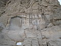
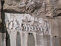
[edit]Mount Bisotoun, aka Bīsitūn (referring to the mountain and the nearby village), is a mountain with a rock precipice in the Zagros Mountains in Kermanshah, Iran. Darius I inscribed the flat rock face in three languages c. 500 BC, known as the Behistun Inscription.[1]
Legends
[edit]
A legend began around Mount Bisotoun, as written about by the Persian poet Nezami about a man named Farhad, who was a lover of Shirin.
Gallery
[edit]-
 Farhad Tarash at the base of Mount Behistun
 -
 Farhad Tarash at the base of Mount Behistun
 -
 Goudarz
 -

-


References
[edit]This Kermanshah province location article is a stub. You can help Wikipedia by adding missing information. |
Mount Behistun
View on Grokipediafrom Grokipedia
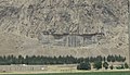
Mount Behistun, also known as Bisotun or Bisotoun, is a sacred mountain in the Zagros range of western Iran, celebrated for its monumental ancient rock reliefs and multilingual inscriptions that illuminate the history of the Achaemenid Empire.[1] Located approximately 30 kilometers northeast of Kermanshah in Kermanshah Province at coordinates 34°23'18"N, 47°26'12"E, the mountain rises to an elevation of about 2,300 meters above sea level and features steep limestone cliffs overlooking a historic trade route that connected the Iranian plateau to Mesopotamia.[2] Its most iconic feature is the Behistun Inscription, commissioned by Darius I in 521 BCE, consisting of a 3-by-5.5-meter bas-relief depicting the king triumphing over rebels, accompanied by around 1,200 lines of cuneiform text in Old Persian, Elamite, and Babylonian, carved approximately 100 meters above the plain on a sheer cliff face.[1] This inscription, spanning 15 meters high and 25 meters wide, not only chronicles Darius's consolidation of power but also served as a pivotal "Rosetta Stone" for the 19th-century decipherment of cuneiform scripts by scholars like Henry Rawlinson.[2] The site encompasses archaeological remains from Middle Paleolithic caves (dating to c. 40,000 BCE) through Median, Achaemenid, Seleucid, Parthian, Sassanian, and Ilkhanid periods, including additional reliefs such as a Seleucid statue of Heracles (148 BCE), Parthian carvings, a Sassanian palace, and an Ilkhanid caravanserai, reflecting continuous human occupation and cultural exchanges over millennia.[1][3] Designated a UNESCO World Heritage Site in 2006 under criteria (ii) and (iii) for its exceptional testimony to intercultural influences in monumental art and writing, as well as its unique documentation of Persian imperial history, the 187-hectare core zone is managed by Iran's Cultural Heritage, Handicrafts and Tourism Organization to preserve its integrity amid natural and developmental threats.[1]