

Community hub
0 subscribers8 pages, 0 posts
Recent from talks
All channels
Be the first to start a discussion here.
Be the first to start a discussion here.
Be the first to start a discussion here.
Be the first to start a discussion here.
Contribute something
Welcome to the community hub built to collect knowledge and have discussions related to Sautron.
Nothing was collected or created yet.
Sautron
View on Wikipediafrom Wikipedia
Sautron (French pronunciation: [sotʁɔ̃] ⓘ; Breton: Saotron) is a commune in the Loire-Atlantique département in western France.
Key Information


Geography
[edit]
Sautron is located 10 km north west of Nantes, close to the Nantes-Vannes expressway.
Surrounding communes are Vigneux-de-Bretagne, Orvault, Saint-Herblain and Couëron.
According to the classification established by INSEE, Sautron is a commune urbaine (urban commune), one of 22 communes in the suburban area of Nantes.
Population
[edit]| Year | Pop. | ±% p.a. |
|---|---|---|
| 1968 | 1,333 | — |
| 1975 | 2,849 | +11.46% |
| 1982 | 4,692 | +7.39% |
| 1990 | 6,026 | +3.18% |
| 1999 | 6,824 | +1.39% |
| 2007 | 6,806 | −0.03% |
| 2012 | 6,989 | +0.53% |
| 2017 | 8,192 | +3.23% |
| Source: INSEE[3] | ||
Sites and monuments
[edit]-
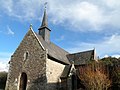
 The church
 -
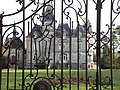 The Château des Croix
 -
 Chapelle de Bongarant


See also
[edit]References
[edit]- ^ "Répertoire national des élus: les maires". data.gouv.fr, Plateforme ouverte des données publiques françaises (in French). 2 December 2020.
- ^ "Populations de référence 2023" (in French). National Institute of Statistics and Economic Studies. 18 December 2025.
- ^ Population en historique depuis 1968, INSEE
External links
[edit]Wikimedia Commons has media related to Sautron.
This Loire-Atlantique geographical article is a stub. You can help Wikipedia by adding missing information. |
Sautron
View on Grokipediafrom Grokipedia
Geography
Location and Borders
Sautron is located in the Loire-Atlantique department of the Pays de la Loire region in western France, with geographical coordinates of approximately 47.262° N latitude and 1.672° W longitude.[7] It lies about 10 kilometers northwest of Nantes, making it part of the Nantes metropolitan area's suburban zone.[8] According to INSEE classification, Sautron is designated as an urban commune within the Unité urbaine 2020 de Nantes.[9] The commune borders Vigneux-de-Bretagne to the north, Orvault to the east, Saint-Herblain to the southeast, and Couëron to the southwest.[10] It benefits from proximity to key infrastructure, including the Nantes-Vannes expressway (Route nationale 165), which facilitates connectivity to the broader region.[11] Sautron's INSEE code is 44194, and its postal code is 44880.[9][7]Physical Features and Climate
Sautron features a gently rolling topography typical of the outskirts of the Loire Valley, with elevations ranging from a minimum of 25 meters to a maximum of 80 meters above sea level, and an average elevation of approximately 60 meters.[12][13] The commune's terrain supports suburban development through its undulating landscape, which includes areas suitable for residential expansion without extreme slopes. The area encompasses minor water bodies and forested regions, notably the Cens Valley with its streams and wooded trails that provide natural green spaces amid the suburban setting.[14][15] These features, including paths along the Erdre River and the Cens stream, contribute to local biodiversity and recreational opportunities.[14] Sautron experiences a temperate oceanic climate influenced by its proximity to the Atlantic Ocean, characterized by mild winters and moderate summers.[16] The average annual temperature is around 12.4°C, with annual rainfall totaling approximately 735 mm, distributed relatively evenly throughout the year but peaking in autumn and winter.[17] This climate pattern, with moderate precipitation levels of 800-900 mm annually in the broader region, fosters a lush environment conducive to agriculture and suburban greenery.[18] According to data from the French Land Register, which excludes lakes, ponds, and glaciers larger than 1 km² as well as river estuaries, Sautron covers an area of 17.28 km², predominantly used for residential and agricultural purposes. This land use supports the commune's transition from rural to suburban character while preserving natural elements.History
Origins and Early Development
The name Sautron derives from the Latin word "saltus," referring to a wooded place or parkland, reflecting the area's historical forested landscape.[19] The earliest recorded form of the name appears as the Latinized "Salterona" in a charter dated 1123, evolving to "Sautron" by 1277 and "Saultron" by 1486.[19] Early mentions of Sautron date to 1025, when historical records reference its forest, and more specifically to 1038, when Count Budic of Nantes and his wife Adois donated land in the forest—known as Bois Garand or Bois-Gragunderram—to the monastery of Saint-Cyr-et-Sainte-Juliette in Nantes to establish a priory for religious services during hunting expeditions in the royal forest.[19] Around this priory, a village began to form, marking the initial settlement patterns of Sautron as a rural parish within the historic Duchy of Brittany.[19] The area also included the ducal domain of Bois-Thoreau, which served as a hunting preserve and remained under the Dukes of Brittany until 1492, frequented by figures such as Jean V, François I, Pierre II, Arthur III, and François II.[19] Feudally, Sautron featured several manors, including Fief-au-Duc, Grande-Noë, and Boistaureau, held by noble families like the Loriot, de Lisle, and Avril, underscoring its ties to Breton feudal structures.[19] Ecclesiastically, Sautron developed strong connections to the Bishopric of Nantes, forming part of the bishop's "Regaires" from 1275 to 1790 and becoming fully under episcopal seigneurie after the death of Anne of Brittany in 1514.[19] The priory of Notre-Dame de Boyas-Garand (later Bongarant or Bois-Garand) was central to this history, established in 1038 and documented with a chapel by 1411; in 1464, Duke François II rebuilt the chapel after a miraculous recovery from a hunting accident involving a wild boar, dedicating it to the Virgin Mary and using it for masses during ducal visits.[19] The parish church of Saint-Jacques et Saint-Philippe, with origins in at least the 15th century, was enlarged in 1470 with a chapel to the Virgin by rector Jean Charette and his mother Mathée Danault, serving a small rural community focused on agricultural and forested land use.[19] A pivotal event in Sautron's early modern history was its integration into the newly formed Loire-Atlantique department following the French Revolution in 1790, which dismantled prior feudal and ecclesiastical lordships and placed the parish under the canton of Orvault and arrondissement of Nantes.[19] Local resistance to these changes was evident in 1795, when counter-revolutionaries known as réfractaires killed Simon Phelippes at the Château des Croix.[19] Prior to the 20th century, Sautron remained a modest rural settlement, as indicated by records of a lay school in 1779 under teacher Sieur Pignot, which served both boarders and day students in a community centered on parish life and land-based activities.[19]Modern History and Urbanization
Following World War II, Sautron underwent significant transformation from a rural settlement to a burgeoning residential suburb, driven by its proximity to Nantes and the broader economic recovery in the Loire-Atlantique region.[20] This period marked the beginning of structured urban expansion, with the creation of the first lotissement, named Val du Cens, in 1966, which initiated organized housing developments and attracted families seeking suburban living.[20] Infrastructure improvements, centered around the former national road linking Nantes to Vannes (now a key commercial axis), facilitated this growth by supporting commerce, municipal services, and community facilities such as schools and recreational areas.[21] In the 1970s and 1980s, Sautron's urbanization accelerated as part of the Nantes metropolitan area's expansion, with the construction of contemporary houses and villas that reflected the influx of senior executives and middle-class residents balancing urban access with natural surroundings.[20] The commune's predominantly pavillonnaire layout—characterized by single-family homes north and south of the central road—emerged during this era, while the northern zones retained rural agricultural character in the Cens valley.[21] Although no major local crises like floods or strikes are prominently documented specific to Sautron, the regional industrial shifts and suburban sprawl from Nantes influenced its development, leading to enhanced road networks and public amenities to accommodate increasing residential density.[22] Recent developments up to 2023 emphasized sustainable urban planning approaches to manage growth while preserving Sautron's semi-rural identity. During her tenure since 2008, which concluded in 2026, Mayor Marie-Cécile Gessant promoted lotissement constructions tailored for young couples, including small pavilions with gardens, to counter an aging population and support controlled expansion.[5][23] The mayor aimed to limit the population to around 10,000 to ensure infrastructure like schools and canteens could keep pace, alongside investments in green spaces, hiking trails, and cycling paths in the northern rural areas for environmental preservation.[5][21] A 2024 exhibition titled Sautron d’hier et d’aujourd’hui further highlighted a century of these transformations, focusing on the evolution of the town center along the route de Vannes and underscoring ongoing efforts to integrate heritage with modern suburban needs.[24]Administration and Politics
Local Government
Sautron is governed by a municipal council consisting of 29 members, as determined by its population size between 5,000 and 9,999 inhabitants under French law. In the 2020 municipal elections, the list led by Marie-Cécile Gessant, affiliated with Divers Droite, secured 26 seats with 75.89% of the vote in the first round, while an opposing list obtained the remaining 3 seats.[25][26] Marie-Cécile Gessant has served as mayor since 2008 and was re-elected for her third term spanning 2020 to 2026.[27][26][28] The commune operates without formal internal administrative divisions, functioning as a unified entity for local decision-making. Sautron forms part of the Nantes Métropole intercommunal structure, which encompasses 24 communes and coordinates services such as urban development and transportation across the metropolitan area; the mayor of Sautron serves as a metropolitan councilor and member of the metropolitan executive bureau.[29][30] Recent policy focuses under the current administration include adherence to the metropolitan Plan Local d'Urbanisme (PLUm), which guides sustainable urban planning and limits soil artificialization within Sautron's boundaries. Public services emphasize efficient waste management, with weekly collection of household waste and recyclables handled by the commune in coordination with Nantes Métropole, alongside efforts to promote composting and reduce landfill use. Local taxes, such as the property tax, are set annually by the council to fund these services and infrastructure maintenance.[31][32] Electoral history since 2000 highlights a pattern of strong majority wins. In 2001, Patrick Messus was elected mayor, serving until 2008. The 2008 elections saw Marie-Cécile Gessant elected with her list gaining a clear majority. In 2014, Gessant was re-elected, with her list achieving an absolute majority in the first round at over 50% of votes. The 2020 election continued this trend of decisive victories for the incumbent-aligned lists.[33][34][35]Heraldry and Administrative Symbols
Sautron does not possess an official coat of arms, as indicated in regional heraldry databases listing it among communes without known blasons.[36] The commune's primary administrative symbol is its municipal logo, which embodies a modern representation of Sautron's identity as a dynamic suburban area with deep roots in its natural and historical landscape.[37] The logo features stylized trees symbolizing the town's origins as a forested area, alongside depictions of the Bongarant bell tower and rooftops that evoke its character as a traditional bourg or small market town.[37] In terms of coloration, the design incorporates green to highlight Sautron's exceptional natural heritage, blue to represent local water bodies such as the Cens and Chézine rivers and the Étang de la Bretonnière, and a vibrant raspberry red accent that signifies ongoing sustainable development efforts, including Agenda 21 initiatives and the S2D program.[37] This palette and motifs tie the logo to the regional identity of Pays de la Loire, emphasizing environmental preservation and historical continuity in a suburban context near Nantes.[37] No specific adoption date for the logo is documented in official records, though it is available in various formats via the commune's graphic charter for public use.[37] No municipal flag is officially described or adopted, with the logo serving as the central emblem for administrative purposes.[37] For further details on these symbols, the official website of Sautron provides downloadable resources and guidelines.[38]Demographics
Population Trends
Sautron has experienced significant population growth since the late 1960s, transforming from a small rural commune into a thriving suburban area within the Nantes metropolitan region. According to official INSEE data, the population stood at 1,333 inhabitants in 1968, rising sharply to 2,849 by 1975, reflecting an average annual growth rate of 11.5% during that period.[3] This rapid expansion continued through the 1980s and 1990s, with the population reaching 4,692 in 1982 (7.3% annual growth from 1975), 6,026 in 1990 (3.2% from 1982), and 6,824 in 1999 (1.4% from 1990).[3] Subsequent years showed more moderate fluctuations, including a slight decline to 6,809 in 2006 (effectively 0.0% annual growth from 1999), followed by steady increases to 6,945 in 2011 (0.4% from 2006), 7,915 in 2016 (2.6% from 2011), and 8,534 in 2022 (1.3% from 2016).[3] The most recent census data indicates further growth, with Sautron's population reaching 8,555 in 2023, marking an average annual increase of 0.7% over the preceding six years.[39] This corresponds to a population density of approximately 495.1 inhabitants per square kilometer in 2023, based on the commune's area of 17.28 square kilometers.[3] [39] The following table summarizes key historical population figures and growth rates from INSEE records:| Year | Population | Annual Growth Rate (%) from Previous Census |
|---|---|---|
| 1968 | 1,333 | - |
| 1975 | 2,849 | 11.5 |
| 1982 | 4,692 | 7.3 |
| 1990 | 6,026 | 3.2 |
| 1999 | 6,824 | 1.4 |
| 2006 | 6,809 | 0.0 |
| 2011 | 6,945 | 0.4 |
| 2016 | 7,915 | 2.6 |
| 2022 | 8,534 | 1.3 |
| 2023 | 8,555 | 0.7 (from 2017 average) |