You can help expand this article with text translated from the corresponding article in Japanese. (June 2015) Click [show] for important translation instructions.
|
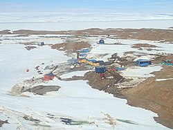
Showa Station (Japanese: 昭和基地, Hepburn: Shōwa Kichi), sometimes alternately spelled Syowa Station,[2] is a Japanese permanent research station on East Ongul Island in Queen Maud Land, Antarctica. Built in 1957, Showa Station is named for the era in the Japanese calendar during which it was established, the Shōwa period.

Showa Station serves as a research outpost for astronomy, meteorology, biology and earth sciences. It comprises over 60 separate buildings, large and small, including a 3-storey administration building, living quarters, power plant, sewage treatment facility, environmental science building, observatory, data processing facility, satellite building, ionospheric station, incinerator, earth science building, and radiosonde station. Also present are fuel tanks, water storage, solar panels, a heliport, water retention dam, and radio transmitter.
Showa station is home to the Program of the Antarctic Syowa Mesosphere–Stratosphere–Troposphere/Incoherent Scatter (PANSY) incoherent scatter radar, which took its first measurements in 2017.[3]
The station was founded by the inaugural Japanese Antarctic Research Expedition in 1957. This expedition was airlifted out after a storm, by a nearby American ship that had a helicopter. However there was no space for the dogs to get on. The storm made deploying the second team impossible in February 1958. In January 1959, the third team returned to the station and found that, of the 15 sled dogs that had been left by the first team at the base, two, Taro and Jiro, had survived.
A cairn and plaque at the station commemorate Shin Fukushima, a member of the 4th Japanese Antarctic Research Expedition, who died in October 1960 while carrying out his duties. The cairn, which contains some of his ashes, was erected on 11 January 1961 by his colleagues. It has been designated a Historic Site or Monument (HSM 2) following a proposal by Japan to the Antarctic Treaty Consultative Meeting.[4]

The climate is classified as an Ice cap climate (Köppen: EF), since there are no months where the average temperature exceeds 0.0 °C (32.0 °F).
| Climate data for Showa Station (1991−2020 normals, extremes 1957−present) | |||||||||||||
|---|---|---|---|---|---|---|---|---|---|---|---|---|---|
| Month | Jan | Feb | Mar | Apr | May | Jun | Jul | Aug | Sep | Oct | Nov | Dec | Year |
| Record high °C (°F) | 10.0 (50.0) |
8.0 (46.4) |
3.6 (38.5) |
0.5 (32.9) |
2.8 (37.0) |
−0.7 (30.7) |
−2.5 (27.5) |
−2.8 (27.0) |
−1.1 (30.0) |
2.6 (36.7) |
7.3 (45.1) |
9.4 (48.9) |
10.0 (50.0) |
| Mean daily maximum °C (°F) | 1.8 (35.2) |
−0.6 (30.9) |
−4.5 (23.9) |
−7.8 (18.0) |
−10.6 (12.9) |
−11.9 (10.6) |
−14.3 (6.3) |
−15.2 (4.6) |
−15.0 (5.0) |
−10.5 (13.1) |
−3.5 (25.7) |
1.1 (34.0) |
−7.6 (18.3) |
| Daily mean °C (°F) | −0.8 (30.6) |
−2.9 (26.8) |
−6.8 (19.8) |
−10.4 (13.3) |
−13.5 (7.7) |
−15.2 (4.6) |
−17.6 (0.3) |
−18.8 (−1.8) |
−18.3 (−0.9) |
−13.3 (8.1) |
−6.3 (20.7) |
−1.5 (29.3) |
−10.5 (13.1) |
| Mean daily minimum °C (°F) | −3.7 (25.3) |
−5.6 (21.9) |
−9.7 (14.5) |
−13.4 (7.9) |
−16.9 (1.6) |
−18.7 (−1.7) |
−21.4 (−6.5) |
−22.8 (−9.0) |
−22.3 (−8.1) |
−17.1 (1.2) |
−9.9 (14.2) |
−4.6 (23.7) |
−13.8 (7.2) |
| Record low °C (°F) | −12.6 (9.3) |
−18.2 (−0.8) |
−25.2 (−13.4) |
−35.9 (−32.6) |
−40.5 (−40.9) |
−38.3 (−36.9) |
−42.7 (−44.9) |
−42.2 (−44.0) |
−45.3 (−49.5) |
−34.7 (−30.5) |
−25.0 (−13.0) |
−12.9 (8.8) |
−45.3 (−49.5) |
| Average relative humidity (%) | 70 | 70 | 71 | 73 | 69 | 68 | 69 | 68 | 67 | 70 | 68 | 70 | 69 |
| Mean monthly sunshine hours | 346.7 | 186.9 | 118.4 | 59.8 | 22.4 | 0.0 | 6.2 | 65.0 | 144.4 | 194.1 | 320.5 | 414.2 | 1,894.4 |
| Source: Japan Meteorological Agency[5] | |||||||||||||
Showa | |||||||||||
|---|---|---|---|---|---|---|---|---|---|---|---|
| Summary | |||||||||||
| Airport type | Private | ||||||||||
| Serves | Syowa | ||||||||||
| Location | East Ongul Island | ||||||||||
| Time zone | (+3) | ||||||||||
| Elevation AMSL | 95 ft / 29 m | ||||||||||
| Coordinates | 69°00′22″S 39°35′24″E / 69.006167°S 39.590000°E | ||||||||||
| Map | |||||||||||
 Showa Location of airfield in Antarctica | |||||||||||
| Runways | |||||||||||
| |||||||||||
| International | |
|---|---|
| National | |