Hubbry Logo
Port LockroyPort LockroyMain
Open search
Port Lockroy
Community hub
Port Lockroy
logo
8 pages, 0 posts
0 subscribers
Be the first to start a discussion here.
Port Lockroy
Port Lockroy
from Wikipedia

The abandoned British base at Port Lockroy, 1962
Port Lockroy is located in Antarctic Peninsula
Port Lockroy
Location of Port Lockroy

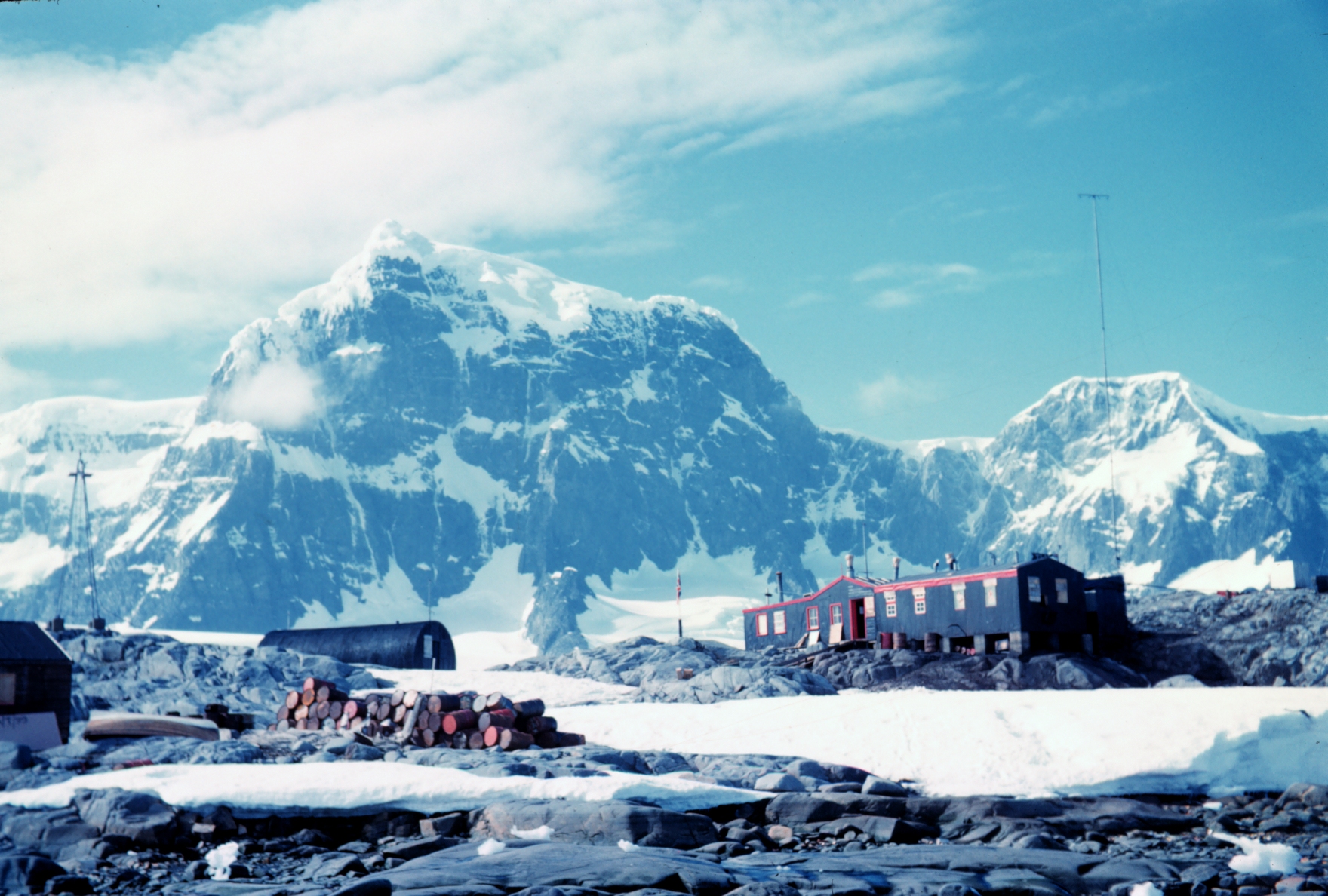
Port Lockroy is a bay forming a natural harbour on the north-western shore of Wiencke Island in the Palmer Archipelago to the west of the Antarctic Peninsula. The Antarctic base with the same name, situated on Goudier Island in this bay, includes the most southerly operational post office in the world. The base was left unstaffed from 2020 to 2022 due to the COVID-19 pandemic, though the museum house remained open to individual visits. On 4 October 2022 it was announced that a team of four women had been chosen to return to open the base for the summer 2022/23 season.[1][2]

Goudier Island in 2014

History

[edit]

The bay was discovered in 1904 and named after Edouard Lockroy, a French politician and Vice President of the Chamber of Deputies, who assisted Jean-Baptiste Charcot in obtaining government funding for his French Antarctic Expedition. The harbour was used for whaling between 1911 and 1931. During World War II, the British military Operation Tabarin established the Port Lockroy Station A on tiny Goudier Island in the bay, which continued to operate as a British research station until January 16, 1962.[3]

In 1996 renovation of the Port Lockroy base buildings was begun by staff from the British Antarctic Survey, funded by the Government of British Antarctic Territory.[4] The United Kingdom Antarctic Heritage Trust took over management and conservation of the site in 2006 and operates a museum and post office staffed in the Antarctic summer (usually November–March).[5]

The base has been renovated into a museum
Food rations on display at the museum

It is one of the most popular tourist destinations for cruise-ship passengers in Antarctica. Proceeds from the small souvenir shop fund the maintenance of the site and other historic sites and monuments in Antarctica.[6] The Trust collects data for the British Antarctic Survey to observe the effect of tourism on penguins. Half the island is open to tourists, while the other half is reserved for penguins. A staff of four typically process 70,000 pieces of mail sent by 18,000 visitors that arrive during the five month Antarctic cruise season.[7][8][9] A souvenir passport stamp is also offered to visitors.[10]

Historic site

[edit]

The historic importance of the site relates to both its establishment as an Operation Tabarin base in 1944, and for the scientific work performed there, including the first measurements of the ionosphere, and the first recording of an atmospheric whistler (electronic waves), from Antarctica. It was also a key monitoring site during the International Geophysical Year (1957). The site has been designated a Historic Site or Monument (HSM 61), following a proposal by the United Kingdom to the Antarctic Treaty Consultative Meeting.[11]

Features

[edit]

See also

[edit]

References

[edit]

Further reading

[edit]
[edit]
Revisions and contributorsEdit on WikipediaRead on Wikipedia
from Grokipedia

Port Lockroy is a natural harbour forming a sheltered anchorage on within the Port Lockroy bay, situated off the north-western coast of Wiencke Island in the Palmer Archipelago of the .
Originally utilized as a station between 1911 and 1931, the site was converted into Britain's first permanent research base, designated Base A, in February 1944 as part of —a wartime initiative to establish a British presence in and counter potential Axis activities.
Occupied intermittently for scientific research until its decommissioning in 1962, Port Lockroy was later restored by the UK Antarctic Heritage Trust, reopening in 1996 as a preserved historic site featuring Bransfield House—a exhibiting artifacts from its and research eras, alongside the world's southernmost operational .
Today, managed seasonally by the Trust, it serves as 's most visited tourist destination, accommodating up to 18,000 visitors per austral summer for guided tours, philatelic services, and wildlife observation of its resident colony, while adhering to strict environmental protocols under the to minimize human impact on the ecosystem.

Geography

Location and Physical Characteristics

Port Lockroy is situated on Goudier Island within the Palmer Archipelago, immediately west of the . The site's coordinates are approximately 64°49′S 63°30′W. Goudier Island lies adjacent to the northwestern shore of Wiencke Island, separated by a narrow channel of about 0.1 km. The area features a natural harbor that offers from the prevailing westerly winds common in the region. This bay, formed by the coastline of Wiencke Island and surrounding smaller islets, provides a protected anchorage amid the otherwise exposed maritime environment of the Palmer Archipelago. The harbor's configuration, influenced by its position at the convergence of ocean currents, contributes to seasonal variability in ice cover, with fast ice typically forming in winter and retreating in summer. Goudier Island itself consists of low-lying, rocky terrain with minimal elevation, characterized by exposed bedrock scoured by glacial action. The surrounding geography includes steep, ice-clad slopes on Wiencke Island, which can channel katabatic winds toward the harbor, though the site's benefits from relative protection within the . Water depths in the harbor accommodate small vessels, with soundings generally exceeding 20 meters in the central basin, subject to tidal ranges of up to 2 meters influenced by semi-diurnal tides. This positioning makes Port Lockroy a strategic coastal feature for access to the Peninsula's inner waterways.

History

Discovery and Early Exploration

Port Lockroy, a natural harbor on the northwestern shore of Wiencke Island in the Palmer Archipelago, was first sighted by Europeans on 19 February 1904 during the French Antarctic Expedition of 1903–1905. Led by aboard the ship Français, the expedition navigated uncharted waters off the , identifying the sheltered bay amid ice-cliffs and peaks during surveys of the region's western coast. Charcot named the site Port Lockroy in honor of Édouard Lockroy, the French politician and of the who had secured essential government funding as Under-Secretary for the Navy, enabling the expedition's departure from in 1903. This recognition underscored Lockroy's role in promoting polar ventures amid France's late entry into Antarctic exploration, following earlier efforts by nations like and Britain. The expedition's overwintering and subsequent charting efforts, including triangulations around Wiencke Island and adjacent features, produced detailed sketches that advanced nautical understanding of the Palmer Archipelago's configuration, previously only partially delineated by sealers and earlier voyages. These surveys, conducted through direct observation and rudimentary instrumentation in harsh conditions, filled gaps in hydrographic data for the Gerlache Strait and coast, facilitating safer navigation without reliance on prior speculative maps. No evidence exists of pre-European human presence in the area, reflecting the continent's isolation and the expedition's pioneering application of empirical coastal profiling in subzero environs.

Whaling Operations

Port Lockroy emerged as a vital anchorage for commercial operations along the starting in 1911, when Norwegian whalers began exploiting its sheltered natural harbor on Goudier Island for mooring floating factory ships and accessing from glacial runoff. Unlike shore-based stations elsewhere, no permanent facilities for processing were constructed at the site; instead, operations relied on pelagic methods pioneered by Norwegian figures such as Carl Anton Larsen, involving catcher boats that harpooned whales at sea and towed them to anchored factory vessels for immediate rendering. These ships, equipped with slipways, decks, and digesters to boil into oil, targeted whales—primarily humpbacks in the early phase—whose oil met surging global demand for industrial uses including production, soaps, and lubricants, fueling economic incentives for expansion. Peak activity aligned with pre-World War I booms, where technological adaptations like steam-powered catchers enabled efficient resource extraction in harsh conditions, though specific catch tallies for Port Lockroy remain undocumented due to its role as a transient support hub rather than a primary processing center. Intensive harvesting driven by oil profitability led to rapid depletion of local humpback stocks by the mid-1920s, as evidenced by broader records showing declining yields from overhunted populations despite initial abundance. This unsustainability, coupled with market shifts toward petroleum derivatives and vegetable oils, eroded economic viability, prompting a transition to fully offshore operations and rendering Port Lockroy's utility obsolete by 1931.

Establishment as British Research Station

Port Lockroy was designated as Base A and established on 11 February under , a clandestine British Admiralty-led initiative authorized by the to secure territorial claims in the amid . The operation's strategic imperatives included denying safe anchorages to potential enemy raiding vessels—such as those from —and countering rival sovereignty assertions by and , which had intensified pre-war activities in the region. Initial occupation involved a team of nine men overwintering in , tasked with continuous presence to affirm British administrative control through documented occupation and scientific output. Scientific mandates at emphasized meteorological monitoring to aid Allied South Atlantic shipping forecasts, alongside geological surveys, topographical mapping, and basic biological observations, all calibrated to substantiate legal claims under effective occupation doctrines. Personnel operated under austere conditions, including nine months of , temperatures dropping below -30°C, and logistical reliance on supply ships navigating ice-choked waters, yet sustained on patterns and terrain features critical for navigation and resource assessment. Infrastructure comprised prefabricated structures engineered for expeditionary durability, notably the Boulton and Paul hut shipped from and erected in February 1944 as the primary shelter, featuring insulated panels and modular assembly for rapid deployment in sub-zero gales and snow accumulation. These huts doubled as laboratories and storage, prioritizing functionality over comfort to enable year-round habitation and survey work in an environment where structural failure posed existential risks.

Post-War Scientific Activities and Closure

![Port Lockroy base in 1962][float-right] Following the end of in 1945, operations at Port Lockroy (Station A) transferred from military control under to the civilian Survey, the predecessor organization to the . Scientific activities emphasized routine meteorological observations, which were transmitted at standard intervals of 0600, 1200, 1800, and 2400 hours GMT, contributing to international weather datasets and early understandings of climate patterns. Biological research focused on local flora and fauna, including botanical surveys that documented and distributions as baseline ecological indicators, while initial geological mapping and topographic surveying expanded regional knowledge of the . By the 1950s, research priorities shifted toward ionospheric studies, with Port Lockroy serving as a key site for upper-atmosphere soundings using ionosondes, alongside continued meteorological and biological monitoring. These efforts produced datasets on ionospheric layers and auroral phenomena, supporting global models of polar atmospheric dynamics during the (1957-1958). Staffing typically consisted of small teams of 4-12 personnel during summer seasons, with winter-over parties maintaining observations; logs from this period, including those from 1949 onward, remain archived for long-term trend analysis in ice and weather variability. Peak activity in the mid-1950s reflected broader Survey expansion, with reoccupation confirmed in February 1952 to ensure continuous data collection. The station closed in January 1962, as research programs relocated to larger, more modern facilities better equipped for advanced and , prioritizing and reduced costs over retention of the aging wartime-era . This decision aligned with post-International Geophysical Year rationalization of British Antarctic operations, where resources shifted to sites offering improved access and expanded capacity, such as those on the with enhanced air and sea support. Archival records from Port Lockroy's final years, including meteorological synopses up to 1962, provided foundational data for subsequent climate and environmental studies, underscoring the base's role in establishing empirical baselines despite its eventual decommissioning.

Preservation and Heritage

Designation as Historic Site

Following the closure of Base A at Port Lockroy in 1962, the site was abandoned for over three decades, during which natural deterioration from weather conditions affected the structures, though many artifacts remained largely untouched. A conservation survey conducted in revealed the base's intact condition, including preserved mid-20th-century equipment and documentation that evidenced its operational history in scientific research and territorial assertion. In recognition of its historical value, Port Lockroy was designated as under the on 19 May 1995, proposed by the to the Antarctic Treaty Consultative Meeting. This status mandates preservation of the three main buildings—Bransfield House, the boat shed, and the generator shed—for their representation of British Antarctic operations from 1944 to 1962, emphasizing empirical records of meteorological observations, hydrographic surveys, and biological studies that advanced understanding of the region's climate and ecosystems. The designation criteria prioritized the site's architectural integrity, with prefabricated structures exemplifying wartime modular construction techniques adapted for polar conditions, alongside unaltered artifacts such as scientific instruments and personal logs that provide direct, verifiable evidence of personnel experiences and data collection efforts. These elements underscored British contributions to knowledge without alteration, distinguishing Port Lockroy from other sites compromised by subsequent modifications or removals.

UK Antarctic Heritage Trust Management

The UK Antarctic Heritage Trust (UKAHT) restored and reactivated Port Lockroy in November 1996, in collaboration with a team, transforming the abandoned base into a functional comprising a museum and post office. This effort involved nine weeks of intensive work to clean, repair, and make the structures weather-tight, addressing deterioration from decades of neglect. UKAHT assumed full operational responsibility in 2006, managing the site as a self-sustaining entity funded primarily through proceeds from an on-site gift shop and postage services, which process approximately 70,000 items annually and support conservation across multiple British Antarctic sites. Administrative protocols emphasize seasonal staffing rotations during the austral summer, with an annual team of specialists—including a base leader, manager, shop manager, , and conservation carpenters—recruited to handle daily operations and maintenance. Artifact conservation adheres to authenticity standards, employing traditional materials and techniques to preserve original furnishings and equipment as a of mid-20th-century life. Key restoration successes include stabilizing the wooden structures against freeze-thaw cycles, a primary degradation factor in the Antarctic Peninsula's climate, through targeted interventions informed by regular building condition surveys and a comprehensive Conservation Management Plan. These measures have extended the site's structural integrity, enabling it to accommodate up to 18,000 visitors per season while maintaining operational self-reliance without reliance on external grants for core upkeep.

Ongoing Conservation Efforts

In 2025, the UK Antarctic Heritage Trust (UKAHT) initiated a three-year conservation project at Port Lockroy, targeting structural vulnerabilities in Bransfield House, particularly its ionospheric room, where moisture ingress has accelerated timber degradation. The first phase, conducted during the 2025 austral summer, involved stabilizing the building through temporary floor propping, damage assessments, and artifact relocation exceeding 0.5 tonnes, alongside testing repair techniques to address rot caused by and increased precipitation. These efforts respond to empirically observed changes, including warmer, wetter conditions fostering rot, growth, and foundation from unmitigated water flow, as documented in site surveys. Subsequent phases, planned for 2026 and 2027, emphasize material reinforcements such as replacing decayed floor timbers, adding structural supports, and installing water-diverting drips on eaves and roofs to counter snow loads and precipitation-driven decay, drawing on assessments of load-bearing capacities and timber durability. Specialist carpenters, including those experienced in prior site works, lead these interventions to enhance resilience without altering historical fabric, prioritizing verifiable outcomes like improved structural integrity over speculative projections. Success metrics focus on reduced deterioration rates, evidenced by post-repair monitoring of moisture levels and timber condition, enabling sustained site accessibility and minimal future interventions. This approach integrates causal analysis of degradation—linking regional precipitation increases to rot acceleration—with practical engineering grounded in Antarctic material performance data.

Facilities and Operations

Bransfield House Museum

Bransfield House, constructed in 1944 as the primary structure of British Base A during , was renovated starting in 1996 by the and converted into a to preserve its historical integrity as a testament to mid-20th-century operations. The building retains its original prefabricated timber frame and internal layout, including living quarters and work areas, offering visitors a reconstructed view of the self-contained environment required for year-round habitation in sub-zero conditions with limited resupply. Exhibits within Bransfield House emphasize the base's operational history through preserved artifacts from the and survey eras, such as meteorological instruments including a sun sphere used for solar measurements, a clandestine radio transmitter installed in for wartime communications, and wind-up gramophones with period like those by Noel Coward. Personal relics, including clothing from personnel, original bedding, canned food rations, and diaries alongside photographs, illustrate the daily challenges of meteorological observations, radio operations, and rudimentary recreation in isolation. Wooden and ship-in-a-bottle models crafted by base inhabitants further highlight the resourcefulness and morale-sustaining activities amid . To maintain the evidentiary value of these artifacts as primary historical sources, visitor protocols enforced by the UK Heritage Trust— which assumed full management in 2006—prohibit direct handling, limit group sizes, and require guided or supervised entry to prevent degradation from human contact or environmental factors. These measures ensure the tangible relics continue to provide unadulterated insights into British self-sufficiency, with conservation efforts focusing on stabilizing materials exposed to humidity and salt corrosion.

Penguin Post Office

The Penguin Post Office, operated within the restored Bransfield House at Port Lockroy, functions as the southernmost public in the world, reopening to visitors in November 1996 under management by the United Kingdom Antarctic Heritage Trust (UKAHT). It handles an estimated 70,000 to 80,000 items of mail per Antarctic summer season (November to March), consisting mainly of tourist postcards and letters destined for global addresses. Staff of four to five personnel manually sort incoming mail by hand, apply bespoke cancellations using a Port Lockroy-specific postmark that includes the date and a penguin emblem, and prepare outgoing items for bulk shipment via supply vessels to the Falkland Islands, from where they enter the British postal network for international delivery. This process, reliant on seasonal cruise ship logistics without fixed aerial or electronic alternatives, ensures delivery times of several weeks to months depending on vessel schedules and weather. Sales of British Antarctic Territory postage stamps, postcards, and philatelic souvenirs generate revenue that directly supports site preservation, with proceeds reinvested into UKAHT's conservation projects across Antarctic heritage locations rather than subsidizing operational costs alone. The service maintains functional continuity with the original postal operations initiated during the British base's establishment in 1944 under , adapting rudimentary wartime communication relays—rooted in the harbor's prior role as a 20th-century fleet anchorage for shelter and message exchange—into a streamlined, revenue-producing utility for modern visitors.

Ecology and Wildlife

Gentoo Penguin Colony

Port Lockroy's Goudier Island hosts a (Pygoscelis papua) colony primarily concentrated in ten sub-colonies amid historic human structures, where birds select nesting sites based on natural preferences for sheltered, guano-enriched slopes and proximity to foraging grounds rather than avoidance of built features. Recent censuses indicate approximately 600 breeding pairs during the austral summer, reflecting fluctuations such as an 83% increase from 535 pairs in 2018 to 978 in 2021 followed by a decline to around 529 pairs post-2021, with overall trends showing no sustained collapse over two decades of monitoring. Breeding commences with adult arrival in late , nest construction using pebbles and in , and clutch-laying of typically two eggs per pair by mid-, with incubation lasting 30-35 days until in ; chicks by late to March after parental provisioning of and small . Foraging patterns involve short-range dives in coastal waters within 10-20 km of the colony, targeting euphausiids like (Euphausia superba) whose abundance directly correlates with chick survival rates and colony persistence, as evidenced by stable productivity metrics absent major prey shortages. The colony demonstrates behavioral plasticity, with birds maintaining nesting densities near legacy whaling-era buildings and adapting to periodic human presence through unaltered huddling, mate-guarding, and chick-rearing routines, underpinned by decadal counts revealing resilience tied to regional krill biomass rather than localized perturbations. Long-term data from annual nest enumerations and chick counts confirm driven by recruitment from and food-driven breeding success, with no empirical basis for claims of irreversible decline at this site.

Long-Term Environmental Monitoring

The United Kingdom Antarctic Heritage Trust (UKAHT), in collaboration with the (BAS), has conducted long-term environmental monitoring at Port Lockroy since the mid-1990s, with intensified visitor impact assessments spanning over a . This program tracks ecological indicators in the (Pygoscelis papua) colony, including population size, breeding success, nesting density, and behavioral responses to human presence, using standardized protocols such as bi-daily nest surveys and annual chick counts. Data collection emphasizes quantifiable metrics like nest occupancy rates and fledging success, collected by on-site staff during the austral summer to establish baselines against which tourism-related disturbances can be evaluated. A 21-year (1996/1997 to 2016/2017) reveals a 24.5% decline (approximately 1.4% per annum) in breeding pairs at Port Lockroy, alongside reduced metrics such as chick . However, parallel declines of similar magnitude were observed at six other tourist-visited colonies and three unvisited sites along the western , indicating that broader environmental factors—such as variability and prey availability—rather than visitor footfall are the primary drivers. Studies specifically assessing effects, including elevations and vigilance behaviors in nesting Gentoo penguins, have found transient physiological responses (e.g., heart rates rising from baseline ~76 bpm to ~135 bpm during close approaches) but no corresponding impacts on nest abandonment, disruption, or overall nesting success attributable to regulated visitor numbers. Mitigation measures, including zoned access restrictions limiting visitors to designated paths and capping daily landings at around 180 individuals, have contributed to the absence of detectable adverse effects from tourism in the monitoring program. During the 2019–2021 tourism hiatus, Gentoo nest numbers temporarily surged by 83% before declining 46%, further underscoring that visitor presence does not suppress population metrics beyond natural variability. These findings prioritize empirical correlations over assumed causal links from human activity, with ongoing data integration supporting to preserve site integrity without presuming inherent visitor harm.

Tourism and Economic Role

Visitor Patterns and Infrastructure

Port Lockroy receives approximately 15,000 to 20,000 visitors annually, primarily passengers during the austral summer from to . These visits are facilitated by members of the International Association of Antarctica Tour Operators (IAATO), which enforces guidelines limiting simultaneous landings to one ship at a time and capping group sizes to manage site capacity. Typically, two ships visit per day at peak times, allowing for guided tours of the historic base while adhering to protocols that minimize disturbance. The site's infrastructure supports this volume through temporary, low-impact adaptations, including designated guided paths that direct foot traffic away from sensitive nesting areas and modular systems for on-site processing of visitor-generated refuse. Seasonal staff from the UK Antarctic Heritage Trust (UKAHT) operate these facilities without installing permanent structures, relying on zodiac landings from anchored vessels and portable equipment to handle high throughput while preserving the site's historic character. This setup enables efficient operations for thousands of daily visitors during peak weeks, with logistics coordinated to ensure rapid turnover and compliance with Treaty site visit guidelines. Operations are financially self-sustaining, with all costs covered by revenue generated from museum entry contributions, gift shop sales, and postage stamps sold at the Penguin Post Office. The post office alone processes around 70,000 postcards each season, directed to over 100 countries, providing a key income stream that funds staffing, maintenance, and broader UKAHT conservation efforts without reliance on external subsidies. This model demonstrates the site's economic viability as a tourism hub, channeling visitor expenditures directly into operational sustainability.

Benefits and Regulatory Framework

Tourism at Port Lockroy contributes to public awareness of exploration and science by providing visitors with direct exposure to historic artifacts, operational demonstrations like postal services, and educational exhibits in Bransfield House, fostering appreciation for empirical fieldwork in extreme environments. The site's , issuing stamps since 2004 under UK Territory authority, has processed over 100,000 items annually in peak seasons, disseminating tangible mementos that extend interest in polar history to global audiences beyond on-site visits. Since the UK Heritage Trust (UKAHT) assumed management in 1996, more than 600,000 visitors have engaged with these elements, amplifying knowledge of British operations without relying on secondary media. Revenues from the gift shop and directly finance site operations and conservation across multiple historic locations, with UKAHT's 2023-24 impact report indicating these funds supported structural repairs and artifact maintenance exceeding operational costs through efficient seasonal management. This model sustains approximately 10-12 seasonal positions annually, including roles in , retail, and site , providing specialized opportunities tied to polar and drawing applicants from international pools. Such economic inputs preserve the site's integrity as a , enabling ongoing access while channeling surplus to broader heritage efforts under UKAHT oversight. Port Lockroy operates under the , designated as Historic Site and Monument No. 61 since 1979, which mandates non-interference with scientific or historic values and prioritizes . Visitor guidelines, established via Antarctic Treaty Consultative Meetings (ATCM), limit simultaneous landings to 100 individuals on Goudier Island and 35 inside Bransfield House to minimize cumulative impacts. The International Association of Antarctica Tour Operators (IAATO), of which UKAHT is an associate member, enforces complementary protocols including pre-visit measures—such as boot cleaning to avert introduction—and vessel-only access for members, ensuring compliance through self-regulation audited annually at ATCMs. These frameworks, binding on Treaty parties, balance with site preservation by capping group sizes and prohibiting activities like artifact handling or overnight stays.

British Territorial Claim

The United Kingdom's territorial claim to the region encompassing Port Lockroy originates from explorations and formal assertions dating to the early , with John Biscoe sighting and claiming the for Britain during his 1830–1832 expedition. This was formalized through the of 1908 and 1917, establishing the UK's oldest continuous claim to Antarctic territory south of 50°S, including the where Port Lockroy is located. Under principles of , such as those in the 1928 Island of Palmas arbitration emphasizing discovery followed by effective occupation, these precedents provide a foundation supported by historical surveys, mapping publications, and whaling industry records documenting British activity in the area. Port Lockroy exemplifies the UK's demonstration of effective control through physical presence and administrative acts, beginning with the establishment of Base A on 11 February 1944 under , a wartime initiative to conduct meteorological and scientific observations while asserting via permanent installations. The base remained occupied continuously until 1962, housing personnel for , mapping, and resource monitoring, which constituted continuous and peaceful display of authority as required for valid occupation under . This occupation provided empirical evidence of development, including published scientific data from on-site surveys that reinforced the claim's validity independent of mere nominal assertions. In 1962, Port Lockroy was incorporated into the newly formed via the (S.I. 1962/400), effective 3 March, separating it administratively from the to streamline governance and underscore Britain's commitment to sustained presence. This administrative act highlighted Port Lockroy's role in maintaining strategic oversight of the peninsula's fisheries and , where British surveys had identified and finfish stocks with potential economic value, thereby justifying ongoing occupation to protect national interests in resource stewardship.

Antarctic Treaty Compliance

Port Lockroy operates under the Antarctic Treaty of 1959, which entered into force in 1961 and designates the continent for peaceful purposes, including scientific investigation and preservation of historical sites, while prohibiting military measures of any kind. The site, including Base A (Station A), was formally designated as Historic Site and Monument No. 61 on May 19, 1995, permitting its use for non-military activities such as museum operations and regulated tourism, provided they do not compromise preservation or environmental standards. This status ensures demilitarization, with no armed forces or bases maintained, aligning directly with Article I's commitment to exclusive peaceful use. Compliance is enforced through the treaty's inspection regime under Article VII, which grants any consultative party the right to inspect facilities; Port Lockroy, as a UK-managed , is included in the Antarctic Treaty Secretariat's inspections database and remains open to such verifications. The actively participates by conducting its own inspections of other Antarctic stations, having covered around 80% of those on the since 2012, thereby upholding reciprocal transparency and operational standards across the treaty area. from ongoing scientific monitoring at the site, such as penguin population studies via the Port Lockroy Portal, is shared among treaty parties to advance research, prioritizing empirical contributions over territorial assertions. The treaty's Article IV explicitly freezes pre-existing territorial claims without prejudice to future resolutions, enabling joint activities at Port Lockroy—managed by the UK Antarctic Heritage Trust since 2006—while the UK retains administrative oversight without conceding underlying rights. Visitor guidelines restrict access to vessels affiliated with the International Association of Tour Operators (IAATO), ensuring supports peaceful and scientific objectives without or disruption. This structure has facilitated sustained operations, with annual summer staffing for functions and monitoring, demonstrating the treaty's framework for balancing preservation, research, and limited human presence.

International Disputes and Claims

The area encompassing Port Lockroy is subject to overlapping territorial claims by , , and the , with asserting sovereignty over its Argentine Antarctic sector (roughly 25°W to 74°W) based on inheritance from Spanish colonial titles, geographical proximity to the , and exploratory expeditions in the , including meteorological stations to demonstrate occupation. similarly claims the (53°W to 90°W) on grounds of from colonial boundaries, contiguity, and 1940s base establishments in the , though these claims prioritize sectoral proximity over site-specific continuous control at locations like Port Lockroy. Neither nor has maintained equivalent year-round physical presence or administrative activities at Port Lockroy itself, relying instead on broader regional assertions without yielding to on the merits of effective occupation. The United Kingdom's claim within the (20°W to 80°W), formalized through ordinances in 1908 and 1917, is substantiated by historical explorations dating to the early and, crucially, effective occupation evidenced by of Base A at Port Lockroy on 11 February 1944 under , a wartime initiative to secure anchorages, conduct meteorological observations, and affirm sovereignty amid perceived threats from and rival claimants. This base operated continuously until 1962 for scientific and administrative purposes, including postal services, providing tangible records of control that the UK cites to rebut Argentine and Chilean contentions, which it views as unsubstantiated by comparable on-site endurance or rejection of contiguity-based theories under precedents favoring actual administration. In 1955, the sought judicial resolution by instituting proceedings at the against and over in the disputed zones, but both refused to accept the Court's compulsory , leaving no formal adjudication. The 1959 Antarctic Treaty, ratified by all three states, preserves the status quo by neither recognizing nor denying claims, prohibiting new assertions, and mandating cooperative scientific use, which has enabled de facto coexistence without concessions to overlapping assertions. Should circumstances evolve, such as a review of the 1991 Madrid Protocol's mining ban after 2048 permitting potential resource activities beyond scientific , the United Kingdom's documented of sustained infrastructure and governance at sites like Port Lockroy positions it advantageously in prioritizing empirical administrative records over theoretical sectoral entitlements.

Controversies and Impacts

Environmental Effects of Tourism

Tourism at Port Lockroy, managed under International Association of Antarctica Tour Operators (IAATO) guidelines, imposes limited ecological stress on the colony through controlled access protocols that cap daily landings at approximately 180 visitors and enforce minimum approach distances of 5 meters. Long-term observations by the (BAS) indicate that gentoo penguins (Pygoscelis papua) have habituated to human presence, frequently approaching visitors within distances below the guideline threshold without exhibiting elevated stress responses or altered foraging behaviors. Breeding success metrics from BAS's 21-year dataset on Goudier Island reveal no statistically significant disruptions attributable to tourism, with population fluctuations more closely correlated to prey availability and dynamics than visitor volumes. Waste generation and emissions from cruise vessels remain negligible relative to historical benchmarks, as modern operators adhere to MARPOL Annex IV prohibitions on sewage discharge south of 60°S and employ advanced ballast water management to prevent non-native species introduction. Annual fuel spills or litter incidents at the site number fewer than one per decade under current oversight, contrasting sharply with whaling-era operations (1911–1931) that deposited thousands of tons of oil residues, waste, and into soils and sediments, persisting as hotspots of polycyclic aromatic hydrocarbons detectable today. These legacy contaminants exceed modern tourism footprints by orders of magnitude, underscoring the efficacy of Protocol on Environmental Protection to the Treaty (1991) in curtailing diffuse pollution sources. Empirical thresholds derived from BAS wildlife monitoring—integrating chick counts, nest occupancy rates, and behavioral assays—enable dynamic adjustment of ship permits, ensuring visitation stays below levels that could trigger density-dependent effects like increased aggression or fledging failure. This data-driven approach not only mitigates potential cons such as localized trampling of mosses but also sustains the longitudinal environmental datasets that inform broader Antarctic conservation, with net ecological benefits evidenced by stable biodiversity indices amid rising global tourism pressures.

Climate Change and Structural Deterioration

The , where Port Lockroy is situated, has observed increased in recent years, with the 2024 season marking one of the wettest in over two decades, featuring only five non-raining days out of 33 working days at the site. This surge in moisture, manifesting as both , has accelerated wood rot in the historic buildings' timber elements, as the structures—constructed in the without drainage systems—retain that promotes fungal decay and structural weakening. Empirical assessments by the UK Antarctic Heritage Trust (UKAHT) attribute this deterioration primarily to excess moisture infiltration rather than solely temperature shifts, though warmer conditions enable greater atmospheric capacity, shifting some from to . In response, UKAHT initiated a three-year conservation mission in the 2025 austral summer, involving specialist carpenters to remove and replace rotten floor timbers, reinforce foundations, and apply protective coatings to mitigate ongoing damage. These targeted repairs prioritize structural integrity through direct intervention, contrasting with emission-reduction by focusing on adaptive measures suited to local conditions. Historical weather records for the Peninsula indicate variability, including multi-decadal fluctuations in precipitation driven by circulation patterns, underscoring that while recent trends show elevated wetness, long-term baselines reveal cyclical elements influenced by natural forcings like anomalies in adjacent regions. Tourism operations at Port Lockroy, generating revenue through and visits, fund these proactive conservation efforts, enabling regular inspections and interventions that avert the unchecked decay observed in unoccupied heritage sites, where isolation exacerbates exposure to freeze-thaw and without human oversight. This human presence facilitates empirical monitoring of degradation drivers, distinguishing site-specific needs from broader climatic narratives.

Debates on Sovereignty and Resource Use

The sovereignty of Port Lockroy, situated within the UK's claimed British Antarctic Territory, remains contested due to overlapping assertions by Argentina and Chile, which the UK has historically rebutted through principles of effective occupation and continuous presence. Established as Base A in 1944, Port Lockroy exemplifies Britain's sustained administrative control, including scientific operations and now heritage management, contrasting with Argentine and Chilean protests that lack equivalent infrastructural commitments in the sector. The 1959 Antarctic Treaty suspends all territorial claims without resolving underlying disputes, prohibiting new assertions while permitting activities like scientific research and tourism to maintain national interests amid frozen sovereignty. This framework underscores tensions where UK's operational stewardship at Port Lockroy prevents de facto abandonment, preserving leverage under occupation doctrine against expansionist interpretations of proximity-based claims by neighbors. Resource debates pivot on the 's allowances for non-exploitative uses versus latent potentials in minerals and fisheries, with the 1991 indefinitely banning mining except for , though reviewable after 2048 amid growing geostrategic pressures. Fisheries in adjacent waters, regulated by the Commission for the Conservation of Antarctic Marine Living Resources (CCAMLR) since 1982, highlight causal trade-offs where controlled harvesting sustains ecosystems better than neglect, yet restrictions prioritize preservation over development, potentially sidelining national resource stewardship. At Port Lockroy, -managed tourism—generating revenue from postal services and souvenirs via the Antarctic Heritage Trust—funds site conservation and broader scientific efforts, embodying measured economic activity that aligns with compliance while countering absolute bans that undervalue human-directed resource optimization. This approach sustains presence, funding over £1 million annually in heritage work as of recent operations, without infringing on environmental protocols. Critics of Argentine and Chilean positions argue their claims reflect expansionism rooted in principles inherited from colonial maps rather than demonstrable occupation, as evidenced by Britain's preemptive base establishments during and ongoing investments absent similar rival developments. Realist assessments favor such persistent national footholds, as tourism at sites like Port Lockroy not only generates fiscal returns for —exceeding £500,000 in souvenir and philanthropic per —but also hedges against post-2048 scenarios where resource interests could resurface, prioritizing causal efficacy of presence over idealistic demilitarization that risks opportunistic voids. This counters environmentalist biases favoring zero-activity preservation, which overlook empirical benefits of revenue-backed stewardship in maintaining territorial realism.

References

Add your contribution
Related Hubs
User Avatar
No comments yet.