
Community hub
Sunda Strait
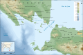
View on WikipediaThe Sunda Strait (Indonesian: Selat Sunda) is the strait between the Indonesian islands of Java and Sumatra. It connects the Java Sea with the Indian Ocean.
Key Information


Etymology
[edit]The strait takes its name from the Sunda Kingdom, which ruled the western portion of Java (an area covering the present day West Java, Jakarta, Banten, and some of western Central Java) from 669 to around 1579.[1]
The name also alludes to the Sundanese people native to West Java and Banten.[1]
Geography
[edit]
Extending in a roughly southwest/northeast orientation, with a minimum width of 24 km (15 mi) at its northeastern end between Cape Tua on Sumatra and Cape Pujat on Java, the strait is part of the Java Sea.[2][3] It is essentially triangular in shape, with two large bays on its northern side. It is also very broad and deep at its southwestern end, but as it narrows to the northeast it becomes much shallower, with a minimum depth of only 20 m (66 ft) in parts of its northeastern end.[3]
The strait is notoriously difficult to navigate because of this shallowness, very strong tidal currents, sandbanks, and man-made obstructions such as oil platforms off the Java coast.[3]
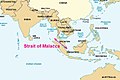
For centuries, the strait was an important shipping route, especially during the period when the Dutch East India Company used it as the gateway to the Spice Islands of Indonesia (1602–1799). However, its narrowness, shallowness, and lack of accurate charting make it unsuitable for many modern, large ships, most of which use the Strait of Malacca instead.[3]
The strait is dotted with a number of islands, many of which are volcanic in origin. They include: Sangiang (Thwart-the-Way), Sebesi, Sebuku, and Panaitan (Prince's). The 1883 eruption of Krakatau, one of these islands, had a profound effect on the area, both short and long term. Tsunamis and pyroclastic flows which floated on clouds of steam killed tens of thousands. Out of 3,000 people on nearby Sebesi at the time, not one survived. Some land was never resettled and became Ujung Kulon National Park.

The Krakatoa eruption drastically altered the topography of the strait, with as much as 18–21 km3 of ignimbrite being deposited over an area of 1.1 million km2 around the volcano. However, the population has recovered and much of the coastline is now very densely populated. Aside from Krakatoa's sole remaining peak, Rakata, the Krakatoa Archipelago consists of the islands of Lang (Panjang or Rakata Kecil), Verlaten (Sertung), and most recently, Anak Krakatau, which emerged in 1927 from the original Krakatoa's shattered remains.
Battle of Sunda Strait
[edit]On March 1, 1942, the Battle of Sunda Strait—part of the larger Battle of the Java Sea—took place when the Allied cruisers HMAS Perth and USS Houston encountered a Japanese amphibious landing force near Bantam, commanded by Rear Admiral Kenzaburo Hara.[4] That force included a light cruiser and eleven destroyers, four heavy cruisers and a light aircraft carrier.[5] The two Allied cruisers were sunk, while a Japanese minesweeper and a transport vessel were sunk by friendly fire.[3]
Planned bridge
[edit]In the 1960s proposals were made for a bridge across the Sunda Strait, and in the 1990s further suggestions arose. A new plan was announced in October 2007. It would use the islands of Ular, Sangiang and Prajurit to create a four-part suspension bridge reaching 70 metres (230 ft) above sea level. This bridge would have a maximum span of 3 kilometers, around 50% longer than the current record holder, the 1915 Çanakkale Bridge. Construction was projected to begin in 2014 if funding of at least US$10 billion could be secured.[6]
An accord was signed in April 2012 with China Railway Construction Corporation for an $11 billion road and double track rail bridge.[7] However, in November 2014 the incoming government of President Joko Widodo shelved plans to build the bridge.[8]
Islands in the strait
[edit]- Calmeyer
- Krakatau Archipelago
- Anak Krakatau
- Krakatau, mostly destroyed volcanic island
- Danan (volcano), destroyed volcanic cone on Krakatau
- Perboewatan, destroyed volcanic cone on Krakatau
- Rakata, partially destroyed volcanic cone and remnant of original island
- Poolsche Hoed, destroyed in 1883 eruption of Krakatoa
- Panjang, or Rakata Ketjil (Lang)
- Sertung (Verlaten)
- Legundi
- Panaitan (Prince's Island)
- Peucang
- Handeuleum
- Sangiang (Thwart-the-way)
- Sebesi
- Sebuku
- Steers (island)
- Tabuan
Bays
[edit]- Lampung Bay, Sumatra
- Semangka Bay, Sumatra
Gallery of nearby important channels
[edit]-

-
 Cocos Strait, Duncan Passage and other Indian channels
 -
 Cocos Strait is at the northern end of Andaman Islands in red square
 -

-
 Ten Degrees Channel, closeup
 -
-

-
 Sunda Strait
 -

-


See also
[edit]- Geostrategic context
- Andaman and Nicobar Command
- Andaman Sea
- Bay of Bengal
- Exclusive economic zone of Indonesia
- Exclusive economic zone of India
- Local context
References
[edit]- ^ a b "Sunda Islands". Concise Dictionary of World Place-Names. John Everett-Heath. Oxford University Press 2005. Oxford Reference Online. Oxford University Press.
- ^ "Limits of Oceans and Seas, 3rd edition" (PDF). International Hydrographic Organization. 1953. Archived from the original (PDF) on 8 October 2011. Retrieved 28 December 2020.
- ^ a b c d e Freeman, Donald B. (2003). Straits of Malacca: Gateway Or Gauntlet?. Montreal: McGill-Queen's University Press. ISBN 0773525157.
- ^ L, Klemen (1999–2000). "Rear-Admiral Kenzaburo Hara". Forgotten Campaign: The Dutch East Indies Campaign 1941-1942.
- ^ Visser, Jan (1999–2000). "The Sunda Strait Battle". Forgotten Campaign: The Dutch East Indies Campaign 1941-1942. Archived from the original on 2014-12-03.
- ^ Forbes, Mark (October 5, 2007). "Bridge plan to link Java and Sumatra". The Age. Melbourne.
- ^ Railway Gazette International June 2012 p25
- ^ Satria Sambijantoro, 'No more Sunda Strait Bridge plan', The Jakarta Post, 3 November 2014. See also 'New Government Will Not Prioritize Sunda Strait Bridge Project' Archived 2019-06-20 at the Wayback Machine, Global Indonesian Voices, 2 November 2014.
| International | |
|---|---|
| National | |
| Other | |