Hubbry Logo
Flores SeaFlores SeaMain
Open search
Flores Sea
Community hub
Flores Sea
logo
8 pages, 0 posts
0 subscribers
Be the first to start a discussion here.
Contribute something
Flores Sea
Flores Sea
from Wikipedia

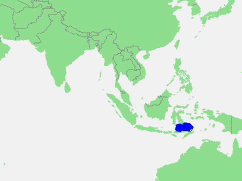
The Flores Sea is a body of water bounded on the north by the Indonesian island of Sulawesi and on the south by the Sunda Islands of Flores and Sumbawa.[1] It covers an area of 121,000 square kilometres (47,000 sq mi).[2]

Key Information

Geography

[edit]
Flores Sea

The seas that border the Flores Sea are the Bali Sea (to the west), the Java Sea (to the northwest), and the Banda Sea (to the east and northeast).

The Indian Ocean and the Savu Sea lie to the south but are separated from the Flores Sea by various islands.

Islands that border this sea are the Lesser Sunda Islands and Celebes (Sulawesi).

Extent

[edit]

The sea is 5,140 metres (16,860 feet) deep.[1] The International Hydrographic Organization (IHO) defines the Flores Sea as one of the waters of the East Indian Archipelago. The IHO defines its limits as follows:[3]

On the North. The South coast of Celebes [Sulawesi] from the West point of Laikang Bay (5°37′S 119°30′E / 5.617°S 119.500°E / -5.617; 119.500) to Tanjong Lassa (120°28'E).

On the East. The Western limit of the Banda Sea between Flores and Celebes [a line from Flores' Northern point (8°04′S 122°52′E / 8.067°S 122.867°E / -8.067; 122.867) to Kalaotoa Island (7°24′S 121°52′E / 7.400°S 121.867°E / -7.400; 121.867) and through the chain of islands lying between it and the South point of Pulo Salayar, through this island and across the Strait to Tanjong Lassa, Celebes (5°37′S 120°28′E / 5.617°S 120.467°E / -5.617; 120.467)].

On the South. The North coasts of Flores, Komodo, Banta, and a line to Tanjong Naroe the Northeast point of Soembawa, thence along its North coast to Tanjong Sarokaja (8°22′S 117°10′E / 8.367°S 117.167°E / -8.367; 117.167).

On the West. A line from Tg Sarokaja to the Western Paternoster island (7°26′S 117°08′E / 7.433°S 117.133°E / -7.433; 117.133) thence to the Northeastern Postiljon Island (6°33′S 118°49′E / 6.550°S 118.817°E / -6.550; 118.817) and to the West point of Laikang Bay, Celebes.

References

[edit]
[edit]
Revisions and contributorsEdit on WikipediaRead on Wikipedia
from Grokipedia
The Flores Sea is a marginal sea of the situated within the Indonesian archipelago, bounded to the north by the island of , to the south by the of Flores and , to the west by the Bali Sea, to the northwest by the , and to the east by the . Covering an area of approximately 240,000 square kilometers, it features diverse physiographic zones, including a broad western plateau at around 500 meters depth, a northern trough reaching 3,370 meters, and the deep Flores Basin in the south with a maximum depth of 5,140 meters. This inter-island sea plays a critical role in regional as part of the Indonesian Throughflow pathway, with approximately 80% of throughflow waters passing through it to facilitate the exchange of water masses between the and Indian Oceans. The Flores Sea's complex , shaped by tectonic processes such as zones and transform faults, supports a dynamic marine environment with strong currents, , and nutrient-rich waters that enhance productivity. It connects to the via the in the northwest, allowing for the influx of warmer Pacific waters that influence local climate and ecosystems. The sea's volcanic undersea features, including seamounts and the active Batu Tara Volcano, contribute to its geological instability, making it prone to earthquakes and occasional tsunamis. The Flores Sea lies within the Coral Triangle and supports exceptional , including diverse scleractinian corals (with the broader region hosting over 590 , primarily from genera such as (104 ), (39 ), and Porites (24 )) and more than 2,000 reef-associated from 113 families. Its coral reefs, mangroves, and seagrass beds support diverse fauna, such as sea turtles (with up to six in Indonesian waters, including the green turtle, Chelonia mydas, and hawksbill, Eretmochelys imbricata), up to 29 cetacean (whales and dolphins across the archipelago), the (Dugong dugon), and pelagic giants like whale sharks (Rhincodon typus) and manta rays (Manta birostris). However, these ecosystems face threats from , , and , with approximately 70% of Indonesian reefs, including those in the Flores Sea, assessed as fair to poor condition as of 2015. The sea's pristine shallower areas, with depths of 50 to 100 meters, attract divers to vibrant sites teeming with , groupers, , and .

Geography

Extent and Boundaries

The Flores Sea is defined by the (IHO) through precise limits established in its 1953 publication on oceans and seas. The northern boundary follows the south coast of (formerly Celebes) from the west point of Laikang Bay at 5°37'S, 119°30'E to Tanjung Lassa at 120°28'E. The eastern boundary aligns with the western limit of the , extending between Flores and . To the south, the boundary traces the north coasts of Flores, Komodo, and Banta islands, then proceeds via a line to Tanjung Naroe (the northeast point of ), and continues along Sumbawa's north coast to Tanjung Sarokaja at 8°22'S, 117°10'E. The western boundary runs from Tanjung Sarokaja to Western Paternoster Island at 7°26'S, 117°08'E, then to Northeastern Postilion Island at 6°33'S, 118°49'E, and finally to the west point of Laikang Bay on . This configuration delineates a marginal sea within the Pacific Ocean's archipelagic waters of , spanning latitudes from approximately 5°31'S to 8°44'S and longitudes from 117°08'E to 122°56'E. The sea's central position is at 7°31'S, 119°50'E. Its surface area measures approximately 240,000 km² (93,000 sq mi), encompassing a significant portion of the inter-island marine space in the Lesser Sunda region. The Flores Sea borders several adjacent bodies of water and oceanic features. To the west, it meets the Bali Sea across the described western line involving the Paternoster and islands. The eastern limit interfaces directly with the , facilitating water exchange between these archipelagic seas. To the northwest, it adjoins the , while southward, beyond the chain of including and Flores, it adjoins the Savu Sea and, ultimately, the . These boundaries position the Flores Sea as a key transitional zone within the Wallacea biogeographic .

Bathymetry and Geology

The Flores Sea features a varied , with depths ranging from shallow coastal shelves to profound basins, reaching a maximum of 5,140 meters in the southern Flores Basin. This central depression forms part of the sea's tectonic framework, where the seafloor transitions from relatively shallow plateaus in the west, around 500 meters, to deeper troughs extending eastward. The underwater topography is dominated by tectonic basins shaped by the ongoing of the Indo-Australian Plate beneath the Eurasian Plate along the , creating a back-arc setting that influences the sea's structural evolution. Seafloor features include prominent seamounts and ridges, which are prevalent in the Flores Sea and adjacent , reflecting active underwater and tectonic deformation. These s, often conical and rising over 1,000 meters from the seafloor, form linear chains associated with subduction-related , such as the Baruna Komba seamount along the Komba Ridge. The ridges and elevated structures interrupt the basin floor, contributing to a complex mosaic of highs and lows that result from compressional forces in the back-arc thrust zone. Geologically, the Flores Sea is integrated into the system, which originated in the Early through processes that initiated formation on . From the onward, the region has been shaped by intense volcanic activity and faulting, with southward of the Flores Basin's driving uplift and deformation along the arc. This history includes a transition from extensional rifting in the to subsequent compressional folding, evident in the back-arc zones. Sediments in the Flores Sea comprise a mixture of terrigenous materials derived from surrounding islands via riverine and coastal erosion, alongside biogenic deposits from marine productivity. Terrigenous muds, rich in silicates and aluminosilicates like and micas, dominate nearshore areas influenced by inputs from local rivers on the surrounding islands. Biogenic components, including oozes from and coccoliths as well as siliceous oozes from diatoms, accumulate in deeper waters, though their preservation decreases below the lysocline due to dissolution. Volcanogenic sediments also contribute, linking to the arc's ongoing magmatic processes.

Adjacent Islands and Coastlines

The Flores Sea is bordered to the north by the southern extent of , a large island characterized by its complex geological structure and mountainous terrain. To the southwest lies , part of the chain, while Flores forms the southeastern boundary with its elongated, volcanic profile stretching over 360 kilometers. These major landmasses enclose the sea. Prominent among the adjacent islands are those within , situated centrally between Sumbawa and Flores; these include the main islands of Komodo, , and Padar, along with 26 smaller islets that collectively span approximately 603 square kilometers of land area. Komodo and , in particular, feature arid, hilly landscapes rising from the sea, with elevations reaching up to 735 meters on Komodo. These islands, geologically linked to the broader of the region, enhance the fragmented nature of the seascape. The coastlines along these islands exhibit distinct features shaped by volcanic activity and tropical marine processes. On Flores and , rugged volcanic coastlines predominate, with steep cliffs, lava-formed headlands, and indented bays resulting from ongoing tectonic and eruptive influences, as seen in the of volcanoes like Tambora on . Fringing reefs extend along many island edges, forming shallow carbonate platforms that buffer the shores against wave action. In more sheltered bays, particularly around Flores and the Komodo group, zones develop in intertidal areas, supporting sediment trapping and coastal stability. The dense clustering of these islands divides the Flores Sea into narrower passages and straits, creating a labyrinthine network that affects maritime navigation. Notable examples include the Sape Strait, which separates from Komodo and links the Flores Sea to the Strait, as well as channels between , Padar, and surrounding islets; these constrictions channel water flows and require careful routing for vessels due to variable depths and tidal influences. Such archipelagic features underscore the sea's role as a transitional zone in the Indonesian Throughflow pathway.

Oceanography

Currents and Circulation

The Flores Sea forms a critical segment of the Indonesian Throughflow (ITF), a major oceanic conveyor transporting warm, low-salinity water from the to the , with an average volume of approximately 15 Sverdrups passing through the region. Water enters the Flores Sea primarily via the in the north, where the ITF's main pathway funnels Pacific waters southward, before exiting through narrower passages such as the , Ombai, and Straits to the south. This throughflow is influenced by the surrounding , creating a predominantly southward-directed current that averages 0.5–1 m/s in the upper layers but varies with depth and season. Circulation in the Flores Sea exhibits strong seasonal reversals driven by the Asian-Australian system, which modulates the ITF's intensity and direction. During the northwest (December–February), upper-layer flows intensify westward or northward due to , while waters (below 200 m) show enhanced southward movement; conversely, the southeast (June–August) strengthens eastward surface flows in the northern sector via the Sunda Shelf Throughflow, with deeper ITF components accelerating southward. These monsoon-driven shifts can reduce overall ITF transport during El Niño events, altering the basin-wide circulation. For instance, during the 2020–2023 triple-dip La Niña, ITF transport via the increased only modestly by 0.3 Sv, contrary to expectations of stronger enhancement. Local circulation patterns are shaped by the irregular of adjacent islands, fostering mesoscale eddies and semi-enclosed gyres that trap and recirculate masses. Cyclonic gyres often form in the central and eastern Flores Sea, influenced by the deflection of ITF waters around Flores and , promoting vertical mixing and enhancing regional connectivity. zones are prominent along the southern coasts of Flores and Islands, where southeasterly winds during the southeast drive offshore, lifting nutrient-rich deeper waters to the surface from April to October, with peak intensity in July–September. These areas contribute to elevated chlorophyll-a concentrations, briefly supporting nutrient distribution that influences local marine productivity. Tidal influences in the Flores Sea are predominantly semi-diurnal, with the constituent dominating energy propagation from the northward through southern straits. In constricted passages like the Selayar Strait, tidal ranges reach up to 2.3 m, generating strong tidal currents of 1–2 m/s that interact with the ITF to produce tidal mixing and enhanced vertical shear. Diurnal tides (K1 and O1) also contribute significantly in the northern Flores Sea, creating mixed tidal regimes that amplify current variability and resuspension in shallow coastal areas.

Physical Properties

The waters of the Flores Sea exhibit a tropical thermal regime, with average surface temperatures ranging from 27°C to 30°C throughout the year, influenced by the region's equatorial position and monsoon-driven patterns. Temperatures decrease with depth, reaching 5–10°C below 1,000 m due to the intrusion of cooler intermediate and deep masses from the Pacific via the Indonesian Throughflow. Salinity in the Flores Sea typically varies between 33 and 34.5 practical salinity units (PSU), reflecting a mix of open-ocean influences and localized freshwater inputs. Levels are slightly lower near river outflows from , where freshwater dilution reduces surface to around 33 PSU during periods of high discharge. In deeper layers, increases to a maximum of approximately 34.6 PSU in the (100–200 m), associated with North Pacific Subtropical Water. Seasonal variations are pronounced, with the sea becoming warmer and more vertically stratified during the dry season (May–October), when surface temperatures often exceed 29°C and evaporation exceeds precipitation. In contrast, the wet season (November–April) promotes greater vertical mixing through increased rainfall and wind-driven turbulence, leading to cooler surface temperatures around 26–27°C and reduced stratification. Dissolved oxygen concentrations are highest in the surface layers (0–60 m), typically ranging from 5.6 to 6.2 mg/L, due to atmospheric exchange and photosynthesis. Levels decline with depth, dropping to 3.3–4.1 mg/L below 200 m, as oxygen consumption in the water column outpaces replenishment. Nutrient profiles show elevated concentrations in deeper waters, with upwelling events bringing nutrient-rich layers toward the surface to enhance overall productivity.

Biodiversity and Ecology

Marine Ecosystems

The Flores Sea hosts a diverse array of marine habitats, primarily shaped by its tropical shallow waters and island archipelagos. Key ecosystems include extensive coral reefs, which form fringing structures along coastlines and include patch reefs, barrier reefs, and atolls in deeper areas. Seagrass beds thrive in sheltered, sandy subtidal zones, supporting interconnected coastal systems, while mangroves fringe the adjacent shorelines of islands like Flores and , providing transitional habitats between terrestrial and marine environments. Deep-sea soft sediments dominate the basin floors beyond the continental shelf, hosting benthic communities adapted to low-light conditions. Ecological zonation in the Flores Sea reflects its bathymetric gradients and hydrodynamic influences. Coral reef ecosystems are concentrated in shallow coastal and shelf areas, covering a significant portion of the seafloor up to depths of 50 meters, while pelagic zones occupy the open waters, characterized by stratified water columns. Transition zones occur in narrow straits such as the Flores Strait, where mixing of shelf and oceanic waters fosters unique habitat interfaces; beds, for instance, exhibit distinct zonation patterns, with multispecies assemblages in subtidal sands giving way to monospecific stands near muddy edges. As part of the Coral Triangle, the Flores Sea exhibits high levels of in its marine biota, influenced by Wallace's Line, which demarcates the biogeographic boundary between Asian and Australasian faunal provinces, leading to distinct evolutionary divergences in reef-associated organisms. This separation enhances across habitats, with the region serving as a critical corridor for larval dispersal and migration. Surface waters in the Flores Sea are generally oligotrophic, with chlorophyll-a concentrations averaging around 0.7 mg m⁻³, varying seasonally from about 0.2 to over 1 mg m⁻³. However, localized events, particularly during the southeast from June to , introduce nutrient-rich deep waters, elevating chlorophyll-a levels up to 1 mg m⁻³ and boosting productivity in areas south of Island and near the Wakatobi Islands.

Flora and Fauna

The Flores Sea, as part of the Coral Triangle, supports a rich marine flora dominated by scleractinian corals, with hundreds of species recorded across its reefs, including prominent genera such as and Porites that form extensive frameworks in shallow waters. Surveys in the region have recorded up to 385 hard coral species. These corals thrive in the nutrient-influenced environments of the sea's fringing and barrier reefs, contributing to high structural complexity that underpins local . Seagrass meadows, particularly those dominated by Enhalus acoroides, are prevalent in sheltered coastal bays and embayments, where they form dense beds supporting herbivorous grazers and stabilizing sediments. Phytoplankton blooms, indicated by elevated chlorophyll-a concentrations, occur seasonally, peaking during the southeast due to and nutrient influx from adjacent straits, forming the base of the pelagic . The sea's fauna encompasses diverse trophic levels, from primary producers like to apex predators such as , with the exhibiting high connectivity across , pelagic, and habitats. Reef-associated exceed 1,000 species, including the large herbivorous bumphead parrotfish (Bolbometopon muricatum), which plays a key role in and algae control on surfaces. This diversity aligns with the broader hotspot, where over 2,000 reef species occur regionally, representing more than a third of global totals. include migratory cetaceans like sperm whales (Physeter macrocephalus), which traverse the sea as part of broader routes influenced by ocean currents, alongside resident populations of manta rays (Mobula alfredi) that aggregate at cleaning stations and feeding grounds. s (Dugong dugon) inhabit areas, grazing on Enhalus acoroides beds in shallow coastal zones. Endemic and cryptic species further highlight the sea's uniqueness, such as pygmy seahorses (Hippocampus bargibanti), which camouflage among gorgonian corals and are integral to the invertebrate assemblage. The trophic structure spans microscopic supporting filter-feeders, mid-level consumers like reef fish, and top predators including gray reef sharks (Carcharhinus amblyrhynchos) that regulate prey populations and maintain ecosystem balance. Cetacean migrations, including those of sperm whales and dolphins, utilize the sea's straits as corridors linking the Indian and Pacific Oceans, facilitating across the Coral Triangle.

Human Use and Economy

Fishing and Resource Extraction

The Flores Sea supports a vital within Indonesia's Area (WPP) 713, encompassing both artisanal and industrial operations targeting species such as (Katsuwonus pelamis), (Thunnus albacares), and reef-associated like snappers and groupers. Artisanal fleets dominate, utilizing traditional pole-and-line methods with live to catch , often aboard iconic schooners originating from South Sulawesi's Konjo builders, which enable multi-day trips across the sea's productive waters. Annual marine capture fisheries production in the adjacent province, which borders the Flores Sea, reached approximately 190,000 metric tons in 2021, reflecting a steady increase from 182,000 tons in 2020 and highlighting the sea's role in sustaining local yields. Industrial purse seine vessels contribute larger volumes of , comprising a mix of juveniles and adults, while artisanal efforts focus on nearshore reef fish, with overall exploitation levels in WPP 713 managed to balance . The sector employs over 50,000 fishers in Province, as of , many relying on small-scale operations for livelihoods. Seaweed farming supplements fishing income in coastal zones around the Flores Sea, particularly in East Flores regency, where Kappaphycus alvarezii is cultivated on longlines in shallow bays, leveraging the nutrient-rich waters for export-oriented production. Beyond fishing, resource extraction includes exploratory efforts for oil and gas in nearby sedimentary basins, such as the Lombok and Bali basins, which hold untapped hydrocarbon potential amid Indonesia's broader petroleum systems. Salt production also occurs via traditional evaporation ponds in adjacent coastal areas like Lombok, drawing seawater into lined salterns for solar crystallization, supporting local industry. Economically, these activities bolster Indonesia's fisheries sector, which contributed 2.46% to national GDP in 2015 through marine capture and exports valued at US$5.72 billion in 2021, with and from Flores Sea regions forming key components of .

Tourism and Recreation

The Flores Sea serves as a premier destination for marine , drawing adventurers primarily for and amid its rich coral reefs and diverse pelagic species. Key attractions include the dive sites within , where strong currents facilitate thrilling drift dives and encounters with vibrant marine ecosystems. Notable spots feature cleaning stations, such as those at Manta Point and Pengah Reef, where divers observe these gentle giants hovering over coral outcrops as smaller fish remove parasites from their undersides. Additionally, WWII-era shipwrecks like the Japanese freighter at Wairterang provide historical exploration opportunities, with the site sloping from 10 to 30 meters and hosting macro life such as nudibranchs and scorpionfish. Visitor numbers to the region, centered around gateway ports like and , have grown steadily, with alone recording approximately 222,000 tourists in 2019 before the ; post-pandemic recovery has seen over 424,000 visitors in 2023, boosting local economies through expanded . These arrivals predominantly focus on sea-based activities, supported by Labuan Bajo's airport and harbor, which handled over 113,000 air passengers and 78,000 harbor visitors in 2015. The area aims for sustainable expansion, with projections targeting up to 500,000 international visitors annually through infrastructure improvements. Tourism infrastructure emphasizes operations, where vessels accommodate 4 to 30 guests for multi-day itineraries accessing remote sites across the Flores Sea. Over 17 dive businesses operate 31 such boats in , offering up to four dives daily while adhering to Indonesian regulations that promote , including waste reduction policies and restricted access to sensitive areas. These measures, enforced under national laws like those governing , limit visitor impacts on and marine habitats through gear restrictions and seasonal protections. Cultural tourism integrates traditional elements, such as sailing experiences on boats—handcrafted wooden schooners originating from —allowing visitors to navigate the Flores Sea while learning about indigenous maritime heritage. These multi-day charters, often departing from , blend relaxation with eco-tours to hidden coves and spots, preserving Bugis seafaring traditions amid modern luxury adaptations.

History and Exploration

Naming and Early Records

The Flores Sea derives its name from the nearby island of Flores, which Portuguese explorers named in the after the word flores, meaning "flowers" in , in reference to the vibrant endemic visible on the island's eastern cape, known as Cabo de Flores. This nomenclature extended to the surrounding waters in colonial-era documentation, reflecting the Portuguese influence in the region during their expansion into the Indonesian archipelago. Early European records of the Flores Sea appear in 16th-century nautical charts, which depicted the Indonesian archipelago's seas and coastlines to facilitate routes and maritime navigation. These maps, produced in workshops in and , emphasized practical sailing details over precise landforms but included the waters between Flores and Celebes () as part of broader representations. By the 17th century, the (VOC), established in 1602, advanced mapping of the through systematic surveys, incorporating pilot logs and hydrographic data to chart regional seas, including those adjacent to Flores. Official VOC cartographers, such as Hessel Gerritsz and the Blaeu family, produced restricted manuscript charts that refined earlier depictions, aiding the company's territorial and commercial interests in the archipelago. The (IHO) formalized the Flores Sea's extent in its 1953 publication Limits of Oceans and Seas, defining it as bounded on the north by the south coast of Celebes from Laikang Bay to Tanjong Lassa, on the east by the western limit of the , on the south by the north coasts of Flores, Komodo, and islands extending to Soembawa, and on the west by a line connecting key points including the Paternoster Islands. In indigenous contexts, the sea is known locally as Laut Flores in Malay and Indonesian languages, a direct translation reflecting its association with the island.

Maritime and Colonial History

During the 16th to 18th centuries, the Flores Sea served as a vital hub in the networks of eastern , connecting ports like on to the clove- and nutmeg-producing via routes through and the Tukangbesi Islands. emerged as a major under the influence of the Gowa-Talloq kingdom, attracting diverse traders including the mobile Sama Bajo who facilitated the exchange of spices, sea cucumbers, tortoiseshell, and slaves across the region. The (VOC) sought to monopolize this trade, establishing control over following the Makassar War (1666–1669) and the Treaty of Bongaya, which restricted local rulers' access to spices and redirected flows through VOC-supervised channels. , on , also fell under Dutch influence as a secondary port, where VOC alliances supported local rulers in taxing marine products like trepang and suppressing smuggling, though clandestine trade persisted in areas like Pota and Reo along the Flores Sea coasts. In the , the Flores Sea became a hotspot for , particularly by seafarers from , who operated from bases in the archipelago to prey on colonial shipping and coastal settlements amid declining VOC power and rising European competition. These activities intensified after the redrew colonial boundaries, disrupting traditional trade and prompting groups to raid vessels carrying goods through the sea's narrow straits, including attacks reported near Island and broader archipelago routes. Dutch colonial authorities responded with naval patrols and alliances with local sultans, such as those in , to curb these operations, though continued to challenge maritime security until the late 1800s. During , the Flores Sea witnessed significant naval operations as part of Japan's rapid expansion into the , with the region serving as a key corridor for Allied supply lines from to . Japanese forces occupied and surrounding areas in 1942, following air raids that secured their advance, while Allied ABDA Command (American-British-Dutch-Australian) attempted to intercept the invasion fleet. The , also known as the Battle of the Flores Sea, occurred on February 4, 1942, when Japanese bombers from Kanoya and Takao air groups attacked the Allied squadron, damaging the USS Houston (48 killed) and USS Marblehead (15 killed) but sinking no vessels in the engagement. This action facilitated Japan's unchallenged landings and control over the sea lanes, though the broader campaign contributed to numerous shipwrecks in adjacent waters like the , underscoring the Flores Sea's strategic vulnerability. Following Indonesian independence on August 17, 1945, the Flores Sea region integrated into the newly proclaimed Republic of Indonesia, with former Dutch territories in eastern , including Flores and surrounding islands, initially forming the short-lived before full unification in 1950. This transition marked the end of colonial maritime dominance, shifting the sea's role from contested trade routes to national waters amid post-war reconstruction and the archipelago's political consolidation.

Conservation and Threats

Environmental Challenges

The Flores Sea faces significant environmental pressures from , particularly through events driven by rising sea surface temperatures and associated phenomena like rapid sea level fall during the 2015–2016 El Niño event. This event triggered widespread coral mortality across Indonesian waters, including the Flores Sea region, disrupting reef ecosystems that support diverse , such as reef-associated and . Additionally, accelerating , projected at 3–4 mm per year in Indonesian waters, exacerbates along the Flores Sea's shorelines, leading to habitat loss in low-lying areas like Aeramo village on Flores Island, where waves have progressively inundated and eroded coastal land. Pollution poses another acute threat, with plastic debris accumulating from maritime shipping and land-based sources. Microplastic concentrations in the Flores Sea's surface waters and range from 0.75 to 2.13 particles per cubic meter, primarily fragments and fibers transported via currents from Indonesian river outflows and shipping activities. These pollutants entangle marine organisms and enter food webs, while agricultural runoff introduces excess nutrients, fostering in coastal zones. Nutrient loads from rivers draining Flores Island's agricultural areas, including and from and farming, elevate blooms that deplete oxygen and harm benthic communities. Overexploitation through illegal and further degrades the sea's habitats and . , involving explosives to stun fish, remains prevalent in Indonesian waters bordering the Flores Sea, causing irreversible damage to structures and reducing by up to 50% in targeted areas like the adjacent Sawu Sea. Illegal, unreported, and unregulated (IUU) fishing depletes pelagic species, while in gillnets and longlines incidentally captures such as sea turtles and cetaceans, contributing to population declines across Southeast Asian seas. Recent development projects on Flores Island have emerged as an additional threat, leading to reports of , water source , and damage to agricultural and coastal habitats as of 2025. and church opposition has prompted reviews and halts to these projects due to environmental impacts. Seismic activity in the tectonically active region amplifies these challenges through events that reshape coastal environments. The 1992 Flores earthquake, magnitude 7.8, generated tsunamis up to 25 meters high that deposited sediments across northern Flores Island's coastlines, smothering mangroves and altering nearshore habitats for years afterward. Such events highlight the vulnerability of the Flores Sea's dynamic to that compound anthropogenic stresses.

Protected Areas and Initiatives

The Flores Sea benefits from several key marine protected areas that safeguard its biodiversity hotspots. , a designated in 1991, encompasses approximately 1,214 km² of marine area within its total 1,817 km² expanse, protecting coral reefs, mangroves, and diverse marine species through regulated zoning and habitat restoration efforts. As part of the broader region, the Flores Sea overlaps with initiatives like the Coral Triangle Initiative on Coral Reefs, Fisheries, and Food Security (CTI-CFF), which supports protected area management in adjacent zones such as Raja Ampat Marine Protected Area, promoting transboundary conservation to address shared ecological connectivity. Indonesia's national strategy under the 2020–2024 National Medium-Term aims to designate at least 20 million hectares of marine protected areas nationwide, representing a commitment to cover 20% of coastal and marine zones with enhanced protections, including expanded no-take zones in the Flores Sea to combat habitat degradation. Complementing this, the CTI-CFF facilitates international partnerships among six countries, including , for restoration projects that involve transplantation and community-based monitoring to rehabilitate damaged ecosystems in the region. Ongoing monitoring programs bolster these protections through systematic reef surveys conducted by organizations like the World Wildlife Fund (WWF) in collaboration with local NGOs, such as the 2017 Alor-Flores expedition that assessed coral health and metrics across key sites. Enforcement efforts target illegal fishing via community-led patrols and government interdictions, with Indonesia's Ministry of Marine Affairs and Fisheries deploying vessels and technology to deter unauthorized activities in Flores Sea waters. Notable successes include the recovery of populations following Indonesia's 2014 nationwide ban on manta fishing and trade, which established the world's largest manta sanctuary spanning 5.8 million km² of EEZ waters. In , post-ban surveys have documented over 1,085 individual reef (Mobula alfredi), with stable residency patterns and improved demographic structures indicating population rebound and effective habitat use.

References

Add your contribution
Related Hubs
Contribute something
User Avatar
No comments yet.