

Community hub
Recent from talks
Contribute something
Nothing was collected or created yet.
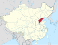
Zhili
View on Wikipedia| Zhili | |||||||||
|---|---|---|---|---|---|---|---|---|---|
 | |||||||||
| Traditional Chinese | 直隸 | ||||||||
| Simplified Chinese | 直隶 | ||||||||
| Literal meaning | Directly Ruled [Region] | ||||||||
| |||||||||
Zhili, alternately romanized as Chihli, was a northern administrative region of China since the 14th century that lasted through the Ming dynasty and Qing dynasty until 1911, when the region was dissolved, converted to a province, and renamed Hopei in 1928. The capital city of Imperial China, Beijing, was located within Zhili.
History
[edit]The name Zhili means "directly ruled" and indicates regions directly ruled by the imperial government of China.[1] Zhili province was first constituted during the Ming dynasty when the capital of China was located at Nanjing along the Yangtze River. In 1403, the Ming Yongle Emperor relocated the capital to Beiping, which was subsequently renamed Beijing.[2] The region known as North Zhili was composed of parts of the modern provinces of Hebei, Henan, Shandong, including the provincial-level municipalities of Beijing and Tianjin. There was another region located around the "reserve capital" Nanjing known as South Zhili that included parts of what are today the provinces of Jiangsu and Anhui, including the provincial-level municipality of Shanghai.
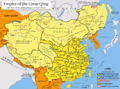
During the Qing dynasty, Nanjing lost its status as the "second capital" and Southern Zhili was reconstituted as a regular province, Jiangnan, while Northern Zhili was renamed Zhili Province. In the 18th century the borders of Zhili province were redrawn and spread over what is today Beijing, Tianjin and the provinces of Hebei, Western Liaoning, Northern Henan, and the Inner Mongolia Autonomous Region.[citation needed]
After the collapse of Qing dynasty, in 1911, the National Government of the Republic of China converted Zhili into a province as Zhili Province. In 1928 the National Government assigned portions of northern Zhili province to its neighbors in the north and renamed the remainder Hebei Province.
See also
[edit]- Sili Province, a similar administrative region during the Han dynasty
- Zhongshu Sheng, a similar administrative region during the Yuan dynasty
- North Zhili and South Zhili, similar administrative regions during the Ming dynasty
Gallery
[edit]-
 Zhili during the Republican era
 -

-
 The eastern half of D'Anville's 1734 map of China, Chinese Tartary, and Tibet, displaying "Pe-tche-li" (North Zhili) after its southern counterpart became known as "Kiang-nan" (Jiangnan)
 -
 The Qing dynasty in 1820, with pinyin romanization
 -
 Administrative map of North Zhili in 1820
 -
 A map from 1861, which shows "Chihli" (Zhili). The former Jiangnan had already been divided between "Kiangsu" (Jiangsu) and "Nganhwui" (Anhui)
_Hopeh.svg)


References
[edit]- ^ Bird, Thomas (2018-08-16). "More than Beijing's backyard: Hebei in China, where historical treasures shine through the pollution". South China Morning Post. Hong Kong. Retrieved 2024-04-01. - See Jeremiah Jenne's statements.
- ^ Susan Naquin, Peking: Temples and City Life, 1400-1900, p xxxiii
External links
[edit]- (in English and Chinese) Complete Map of the Seven Coastal Provinces from 1821 to 1850
Zhili
View on GrokipediaEtymology
Name and historical designations
The term Zhili (直隶; Zhílì) literally translates to "directly ruled" or "directly subordinate" in Chinese, denoting territories placed under the immediate administrative control of the imperial court, bypassing regional governors or intermediate bureaucratic layers to ensure centralized authority. This nomenclature underscored the strategic importance of the area surrounding the capital, where direct oversight facilitated rapid policy implementation and resource mobilization for the throne.[6][5] During the Ming dynasty (1368–1644), the northern region was formally designated Beizhili (北直隶; Běizhílì), meaning "Northern Directly Ruled," to differentiate it from Nanzhili (南直隶; Nánzhílì), or "Southern Directly Ruled," which encompassed areas around Nanjing, the initial Ming capital. This bifurcation reflected the dual-capital system after the Yongle Emperor relocated the primary seat of power to Beijing in 1421, yet retained Nanjing's symbolic status. The Zhili label thus emphasized not regional autonomy but the emperor's unmediated governance over core heartlands.[6][7] Under the Qing dynasty (1644–1912), with Beijing as the undisputed capital, the northern entity was simply termed Zhili Province (直隶省; Zhílǐ Shěng), dropping the directional prefix while maintaining the connotation of direct imperial attachment; the former Nanzhili had been reorganized into Jiangsu and Anhui provinces by 1667. Western cartographers romanized it as "Chihli" or "Pe-tche-li," as seen in 18th- and 19th-century maps, preserving the phonetic rendering of its administrative significance without altering its etymological roots in centralist hierarchy.[5][7]Geography
Territorial boundaries and extent
Zhili Province, as the directly administered territory surrounding the Qing capital at Beijing, encompassed an area roughly equivalent to the core of modern Hebei Province, including Beijing and Tianjin but excluding western and eastern peripheral districts that were later organized separately, such as Rehe and Chahar.[6][8] This territory spanned approximately 130,000 square kilometers, centered on the North China Plain.[9] Its northern boundaries extended into regions now part of Inner Mongolia, with jurisdictional overlaps involving Mongol leagues under the Lifan Yuan.[6][10] To the south, the province bordered Henan along the Yellow River. The eastern extent reached the Bohai Sea, facilitating maritime access near Tianjin. Western limits followed the Taihang Mountains, abutting Shanxi Province.[6][11] Due to Zhili's status as a directly controlled province under the imperial court, its borders remained somewhat fluid throughout the Qing era, subject to administrative reallocations for strategic or fiscal purposes, as documented in 19th-century gazetteers and official maps.[12][13] These adjustments prioritized central oversight over fixed provincial demarcation, distinguishing Zhili from outer provinces.Physical geography and climate
Zhili Province occupied a central position on the North China Plain, a vast alluvial expanse formed by sediment deposits from the Yellow River and its tributaries, featuring deep, fertile loess and silt soils that supported intensive agriculture, particularly wheat and millet cultivation. This lowland terrain, averaging 50 meters above sea level, extended across much of the province's interior, fostering dense rural populations but limiting topographic diversity. To the west, the Taihang Mountains rose sharply as a fault-block range, attaining elevations of 1,000 to 1,200 meters and serving as a watershed divide between the plain and the drier loess plateau beyond, while narrower coastal plains fringed the eastern seaboard along the Bohai Gulf, incorporating tidal flats and estuaries suitable for salt production.[14][15] The province's drainage was centered on the Hai River system, a network of five principal tributaries—the Yongding River from the Taihang foothills, the Chao River from the Yan Mountains to the north, the Ziya and Daqing rivers from the south, and segments of the Grand Canal—converging near Tianjin before emptying into the Bohai Sea. These waterways, fed by seasonal monsoon rains and snowmelt, enabled irrigation and transport via the canal's northern branches but amplified flood hazards through siltation and channel shifts, as documented in Qing-era flood records. Settlement concentrated along these fertile valleys, though the flat topography offered scant natural flood barriers, contributing to recurrent inundations that disrupted agrarian economies.[16] Zhili's climate followed a temperate monsoon pattern, marked by cold, arid winters with Beijing-area January averages near -5°C and hot, humid summers peaking at 30°C in July, driven by the East Asian monsoon that delivered 60-70% of annual precipitation (approximately 600 mm) between June and August. Historical reconstructions reveal decadal temperature swings exceeding 1°C in the North China Plain during the Qing period, intensifying crop failures amid variable rainfall. The region suffered frequent extremes, including prolonged droughts like the 1876-1879 North China Famine, which devastated Zhili's harvests through arid conditions and locust plagues, killing millions, and Yellow River floods spilling into Hai tributaries, as chronicled in imperial gazetteers and relief memorials. Such vulnerabilities stemmed from the plain's reliance on precise seasonal rains, with deficiencies or excesses routinely triggering famines and migrations.[17][18][19]History
Origins and early establishment
The region comprising Zhili emerged during the Yuan dynasty (1271–1368) as the core administrative zone surrounding the capital Dadu (modern Beijing), established by Kublai Khan in 1272 to centralize control over conquered Chinese territories and facilitate Mongol oversight of the empire's southern domains.[20] This area, encompassing parts of modern Hebei, Beijing, and Tianjin, prioritized direct imperial administration to manage taxation, military garrisons, and communication routes, reflecting the Yuan's hierarchical structure where the capital region operated under the Zhongshu Sheng secretariat without intermediate provincial layers.[21] With the founding of the Ming dynasty in 1368, the northern territory was reorganized under direct central authority, initially as part of the Beiping administrative setup before being formalized as Beizhili (North Zhili) in 1407 during the Yongle Emperor's reign (1402–1424), distinguishing it from Nanzhili around Nanjing and underscoring its role as the metropolitan hub after Beijing's designation as capital in 1421.[22] This structure bypassed delegated provincial governance, placing prefectures like Shuntian (Beijing) and Baoding under the immediate jurisdiction of the Six Ministries in the capital to ensure efficient resource allocation and loyalty in the politically sensitive northern frontier. Baoding, as a key secondary center, supported early urbanization, with Ming household registrations indicating dense settlement patterns driven by agricultural productivity and proximity to the capital.[23] Following the Qing conquest of Beijing in 1644, the Manchu rulers retained Zhili's direct-governed status, as affirmed in Shunzhi-era edicts (1644–1661), to secure the vulnerable capital against Han resistance and Mongol threats, maintaining centralized military and fiscal control without appointing a full viceroy akin to outer provinces.[7] This continuity emphasized causal priorities of regime stability, with the region's strategic encirclement of Beijing necessitating undivided imperial oversight rather than regional autonomy.[1]Administration and role in the Qing dynasty
Zhili Province was governed through a centralized structure under the Viceroy of Zhili (Zhili Zongdu), a position established to oversee military, civil, and political affairs directly subordinate to the imperial throne. This viceroy managed the core region encompassing modern Hebei, Beijing suburbs, and Tianjin, ensuring tight control over the capital's environs following the Qing conquest of Beijing in 1644.[24][25] The role's prestige stemmed from its proximity to the Forbidden City, positioning it as the most influential among Qing viceroys, with responsibilities extending at times to adjacent provinces like Shandong and Henan for coordinated defense and administration.[4] Tax collection and grain tribute formed a cornerstone of Zhili's administrative duties, channeling resources to sustain the Beijing court and its vast bureaucracy. The province's fertile North China Plain enabled substantial agricultural output, including rice and wheat, which supported local levies and supplemented the southern grain tribute transported via the Grand Canal.[24] Records from the Qing period highlight Zhili's role in the caoliang system, where grain was amassed for imperial needs, with the viceroy supervising distribution to prevent shortages in the capital amid fluctuating harvests.[26] This integration underscored the province's economic primacy, as land taxes in silver and grain directly funded military garrisons and palace expenditures.[27] Zhili's strategic location facilitated rapid imperial responses to internal threats, exemplifying effective centralized command. During the Eight Trigrams uprising of 1813, linked to White Lotus sects, rebels infiltrated the Forbidden City while unrest spread across Zhili, Shandong, and Henan; the viceroy mobilized nearby Banner troops to quell the disorder within months, minimizing disruption to core governance.[28] Such proximity to elite forces, including the Eight Banners stationed in Beijing, allowed for swift suppression compared to distant provinces, reinforcing Zhili's function as the dynasty's defensive bulwark.[25] This administrative model prioritized causal linkages between imperial oversight and regional stability, averting broader escalations through preemptive action.[24]