

Community hub
Recent from talks
Contribute something
Nothing was collected or created yet.
Inner Mongolia
View on Wikipedia
Key Information


.svg)
| Inner Mongolia | |||||||||||||||||||||||||||||||||||||||
|---|---|---|---|---|---|---|---|---|---|---|---|---|---|---|---|---|---|---|---|---|---|---|---|---|---|---|---|---|---|---|---|---|---|---|---|---|---|---|---|
"Inner Mongolia" in Chinese characters | |||||||||||||||||||||||||||||||||||||||
 "Inner Mongolia" in Mongolian script | |||||||||||||||||||||||||||||||||||||||
| Chinese name | |||||||||||||||||||||||||||||||||||||||
| Simplified Chinese | 内蒙古 | ||||||||||||||||||||||||||||||||||||||
| Traditional Chinese | 內蒙古 | ||||||||||||||||||||||||||||||||||||||
| Hanyu Pinyin | Nèi Měnggǔ | ||||||||||||||||||||||||||||||||||||||
| Literal meaning | Inner Mongolia | ||||||||||||||||||||||||||||||||||||||
| |||||||||||||||||||||||||||||||||||||||
| Inner Mongolia Autonomous Region | |||||||||||||||||||||||||||||||||||||||
| Simplified Chinese | 内蒙古自治区 | ||||||||||||||||||||||||||||||||||||||
| Traditional Chinese | 內蒙古自治區 | ||||||||||||||||||||||||||||||||||||||
| Hanyu Pinyin | Nèiměnggǔ Zìzhìqū | ||||||||||||||||||||||||||||||||||||||
| |||||||||||||||||||||||||||||||||||||||
| Mongolian name | |||||||||||||||||||||||||||||||||||||||
| Mongolian Cyrillic | Өвөр Монгол | ||||||||||||||||||||||||||||||||||||||
| Mongolian script |
| ||||||||||||||||||||||||||||||||||||||
| |||||||||||||||||||||||||||||||||||||||
| Uyghur name | |||||||||||||||||||||||||||||||||||||||
| Uyghur | ئىچكى موڭغۇل ئاپتونوم رايونى | ||||||||||||||||||||||||||||||||||||||
| |||||||||||||||||||||||||||||||||||||||
| Manchu name | |||||||||||||||||||||||||||||||||||||||
| Manchu script |
| ||||||||||||||||||||||||||||||||||||||
| Romanization | Dorgi monggo | ||||||||||||||||||||||||||||||||||||||
| Buryat name | |||||||||||||||||||||||||||||||||||||||
| Buryat | Үбэр Монгол Über Mongol | ||||||||||||||||||||||||||||||||||||||
| Kyrgyz name | |||||||||||||||||||||||||||||||||||||||
| Kyrgyz | ىچكى مونعولىيا Ichki Mongolia | ||||||||||||||||||||||||||||||||||||||
| Kazakh name | |||||||||||||||||||||||||||||||||||||||
| Kazakh | ىشكى موڭعوليا Işkı Moñğolia | ||||||||||||||||||||||||||||||||||||||
| Tuvan name | |||||||||||||||||||||||||||||||||||||||
| Tuvan | Övür Mool oran Өвүр Моол оран | ||||||||||||||||||||||||||||||||||||||
| Standard Tibetan name | |||||||||||||||||||||||||||||||||||||||
| Standard Tibetan | ནང་སོག་རང་སྐྱོང་ལྗོངས། | ||||||||||||||||||||||||||||||||||||||
Inner Mongolia,[a] officially the Inner Mongolia Autonomous Region,[b] is an autonomous region of China. Its border includes two-thirds of the length of China's border with the country of Mongolia. Inner Mongolia also accounts for a small section of China's border with Russia (Zabaykalsky Krai). Its capital is Hohhot; other major cities include Baotou, Chifeng, Tongliao and Ordos.
The autonomous region was established in 1947, incorporating the areas of the former Republic of China provinces of Suiyuan, Chahar, Rehe, Liaobei, and Xing'an, along with the northern parts of Gansu and Ningxia.
Its area makes it the third largest Chinese administrative subdivision, constituting approximately 1,200,000 km2 (463,000 sq mi) and 12% of China's total land area. Due to its long span from east to west, Inner Mongolia is geographically divided into eastern and western divisions. The eastern division is often included in Northeastern China (Dongbei), with major cities including Tongliao, Chifeng, Hailar, and Ulanhot. The western division is included in North China, with major cities including Baotou and Hohhot. It recorded a population of 24,706,321 in the 2010 census, accounting for 1.84% of Mainland China's total population. Inner Mongolia is the country's 23rd most populous province-level division.[7] Han Chinese make up the majority of the population in the region; Mongols constitute a significant minority with over 4 million people,[8] making it the largest Mongol population in the world (larger than that of the country Mongolia).[9] Inner Mongolia is one of the more economically developed provinces in China with annual GDP per capita at US$14,343 (2022), ranked 8th in the nation. The official languages are Mandarin and Mongolian, the latter of which is written in the traditional Mongolian script, as opposed to the Mongolian Cyrillic alphabet, which is used in the country of Mongolia, formerly described as Outer Mongolia.
Etymology
[edit]This section possibly contains original research. (December 2019) |
In Chinese, the region is known as "Inner Mongolia", where the terms of "Inner" and "Outer" are derived from Manchu dorgi and tulergi (cf. Mongolian dotugadu and gadagadu). Inner Mongolia is distinct from Outer Mongolia, which was a term used by the Republic of China and previous governments to refer to what is now the independent state of Mongolia and the Republic of Tuva in Russia. The term Inner 内 (Nei) referred to the Nei Fan 内藩 (Inner Tributary), i.e., those descendants of Genghis Khan who were granted the title khan (king) in the Ming and Qing dynasties and lived in part of southern Mongolia.
Due to the perceived Sinocentric nature of the name "Inner Mongolia", some Mongols outside of China, particularly those in the state of Mongolia and separatist groups in the West, prefer the name "Southern Mongolia". However, this name has not been adopted officially by any government bodies.[10]
History
[edit]Much of what is known about the history of the Mongolian Plateau is taken from Chinese chronicles and historians. Before the rise of the Mongols in the 13th century, what is now central and western Inner Mongolia, especially the Hetao region, alternated in control between Chinese farming communities in the south, and Xiongnu, Xianbei, Khitan, Jurchen, Tujue, and nomadic Mongol of the north. The historical narrative of what is now Eastern Inner Mongolia mostly consists of alternations between different Tungusic and Mongol tribes, rather than the struggle between nomads and Chinese farmers.
Early history
[edit]Slab Grave cultural monuments are found in Northern, Central and Eastern Mongolia, Inner Mongolia, North-Western China, Southern, Central-Eastern and Southern Baikal territory. Mongolian scholars prove that this culture related to the Proto-Mongols.[11]
During the Zhou dynasty, Central and Western Inner Mongolia (the Hetao region and surrounding areas) were inhabited by nomadic peoples such as the Loufan, Linhu and Dí, while Eastern Inner Mongolia was inhabited by the Donghu. During the Warring States period, King Wuling (340–295 BC) of the state of Zhao based in what is now Hebei and Shanxi Provinces pursued an expansionist policy towards the region. After destroying the Dí state of Zhongshan in what is now Hebei province, he defeated the Linhu and Loufan and created the Yunzhong Commandery near modern Hohhot. King Wuling of Zhao also built a long wall stretching through the Hetao region. After Qin Shi Huang created the first unified Chinese empire in 221 BC, he sent the general Meng Tian to drive the Xiongnu from the region and incorporated the old Zhao wall into the Qin dynasty Great Wall of China. He also maintained two commanderies in the region: Jiuyuan and Yunzhong and moved 30,000 households there to solidify the region. After the Qin dynasty collapsed in 206 BC, these efforts were abandoned.[12]
During the Western Han dynasty, Emperor Wu sent the general Wei Qing to reconquer the Hetao region from the Xiongnu in 127 BC. After the conquest, Emperor Wu continued the policy of building settlements in Hetao to defend against the Xiong-Nu. In that same year, he established the commanderies of Shuofang and Wuyuan in Hetao. At the same time, what is now Eastern Inner Mongolia was controlled by the Xianbei, who would, later on, eclipse the Xiongnu in power and influence.
During the Eastern Han dynasty (25–220 AD), Xiongnu who surrendered to the Han dynasty began to be settled in Hetao and intermingled with the Han immigrants in the area. Later on, during the Western Jin dynasty, it was a Xiongnu noble from Hetao, Liu Yuan, who established the Han Zhao kingdom in the region, thereby beginning the Sixteen Kingdoms period that saw the disintegration of northern China under a variety of Han and non-Han (including Xiongnu and Xianbei) regimes.
The Sui dynasty (581–618) and Tang dynasty (618–907) re-established a unified Chinese empire and like their predecessors, they conquered and settled people into Hetao, though once again these efforts were aborted when the Tang empire began to collapse. Hetao (along with the rest of what now consists Inner Mongolia) was then taken over by the Liao dynasty founded by the Khitans, a nomadic people originally from what is now the southern part of Manchuria and Eastern Inner Mongolia. They were followed by the Western Xia of the Tanguts, who took control of what is now the western part of Inner Mongolia (including Western Hetao). The Khitans were later replaced by the Jurchens, precursors to the modern Manchus, who established the Jin dynasty over Manchuria and Northern China.
Mongol and Ming periods
[edit].jpeg)

After Genghis Khan unified the Mongol tribes in 1206 and founded the Mongol Empire, the Tangut Western Xia empire was ultimately conquered in 1227, and the Jurchen Jin dynasty fell in 1234. In 1271, Kublai Khan, the grandson of Genghis Khan established the Yuan dynasty. Kublai Khan's summer capital Shangdu (aka Xanadu) was located near present-day Dolonnor. During that time Ongud and Khunggirad peoples dominated the area of what is now Inner Mongolia. After the Yuan dynasty was overthrown by the Han-led Ming dynasty in 1368, the Ming captured parts of Inner Mongolia including Shangdu and Yingchang. The Ming rebuilt the Great Wall of China at its present location, which roughly follows the southern border of the modern Inner Mongolia Autonomous Region (though it deviates significantly at the Hebei-Inner Mongolia border). The Ming established the Three Guards composed of the Mongols there. Soon after the Tumu incident in 1449, when the Oirat ruler Esen taishi captured the Chinese emperor, Mongols flooded south from Outer Mongolia to Inner Mongolia. Thus from then on until 1635, Inner Mongolia was the political and cultural center of the Mongols during the Northern Yuan dynasty.[13]
Qing period
[edit]The eastern Mongol tribes near and in Manchuria, particularly the Khorchin and Southern Khalkha in today's Inner Mongolia intermarried, formed alliances with, and fought against the Jurchen tribes until Nurhaci, the founder of the new Jin dynasty, consolidated his control over all groups in the area in 1593.[14] The Manchus gained far-reaching control of the Inner Mongolian tribes in 1635, when Ligden Khan's son surrendered the Chakhar Mongol tribes to the Manchus. The Manchus subsequently invaded Ming China in 1644, bringing it under the control of their newly established Qing dynasty. Under the Qing dynasty (1644–1912), the Mongolian Plateau was administered in a different way for each region:


- "Outer Mongolia": This region corresponds to the modern state of Mongolia, plus the Russian-administered region of Tannu Uriankhai, and modern-day aimag of Bayan-Ölgii which historically was a part of northern Xinjiang under China's Qing Dynasty. It included the four leagues (aimag) of the Khalkha Mongols north of the Gobi Desert, as well as the Tannu Uriankhai which largely corresponds to modern-day Tuva Republic of Russia, and Khovd regions in northwestern Mongolia, which were overseen by the General of Uliastai from the city of Uliastai.
- "Inner Mongolia": This region corresponded to most of modern Inner Mongolia and some neighbouring areas in Liaoning and Jilin provinces. The banners and tribes in this region came under six leagues (chuulghan): Jirim, Juuuda, Josutu, Xilingol, Ulanqab, and Yekejuu.
- "Taoxi Mongolia": The Alashan Öölüd and Ejine Torghuud banners were separate from the aimags of Outer Mongolia and the chuulghans of Inner Mongolia. This territory is equivalent to modern-day Alxa League, the westernmost part of what is now Inner Mongolia.
- The Chahar Banners were controlled by the military commander of Chahar (now Zhangjiakou). Their extent corresponded to southern Ulanqab and Bayannur in modern Inner Mongolia, plus the region around Zhangjiakou in Hebei province. At the same time, the jurisdiction of some border departments of Zhili and Shanxi provinces also belonged to this region.
- The Guihua Tümed banner was controlled by the military commander of Suiyuan (now Hohhot). This corresponds to the vicinities of the modern city of Hohhot. At the same time, the jurisdiction of some border departments of modern Shanxi province also belonged to this region.
- The Hulunbuir region in what is now northeastern Inner Mongolia was part of the jurisdiction of the General of Heilongjiang, one of the three generals of Manchuria.
The Inner Mongolian Chahar leader Ligdan Khan, a descendant of Genghis Khan, opposed and fought against the Qing until he died of smallpox in 1634. Thereafter, the Inner Mongols under his son Ejei Khan surrendered to the Qing. Ejei Khan was given the title of Prince (親王; qīn wáng), and Inner Mongolian nobility became closely tied to the Qing royal family and intermarried with them extensively. Ejei Khan died in 1661 and was succeeded by his brother Abunai. After Abunai showed disaffection with Manchu Qing rule, he was placed under house arrest in 1669 in Shenyang and the Kangxi Emperor gave his title to his son Borni. Abunai then bid his time and then he and his brother Lubuzung revolted against the Qing in 1675 during the Revolt of the Three Feudatories, with 3,000 Chahar Mongol followers joining in on the revolt. The revolt was put down within two months, the Qing then crushed the rebels in a battle on 20 April 1675, killing Abunai and all his followers. Their title was abolished, all Chahar Mongol royal males were executed even if they were born to Manchu Qing princesses, and all Chahar Mongol royal females were sold into slavery except the Manchu Qing princesses. The Chahar Mongols were then put under the direct control of the Qing Emperor, unlike the other Inner Mongol leagues which maintained their autonomy.
Despite officially prohibiting Han Chinese settlement on the Manchu and Mongol lands, by the 18th century the Qing decided to settle Han refugees from northern China who were suffering from famine, floods, and drought into Manchuria and Inner Mongolia. As a result, the Han Chinese farmed 500,000 hectares in Manchuria and tens of thousands of hectares in Inner Mongolia by the 1780s.[15]
Ordinary Mongols were not allowed to travel outside their own leagues. Mongols were forbidden by the Qing from crossing the borders of their banners, even into other Mongol Banners and from crossing into neidi (the Han Chinese 18 provinces) and were given serious punishments if they did in order to keep the Mongols divided against each other to benefit the Qing.[16] Mongol pilgrims wanting to leave their banner's borders for religious reasons such as pilgrimage had to apply for passports to give them permission.[17]
During the eighteenth century, growing numbers of Han Chinese settlers had illegally begun to move into the Inner Mongolian steppe. By 1791, there had been so many Han Chinese settlers in the Front Gorlos Banner that the jasak had petitioned the Qing government to legalise the status of the peasants who had already settled there.[18]
During the nineteenth century, the Manchus were becoming increasingly sinicised and faced with the Russian threat, they began to encourage Han Chinese farmers to settle in both Mongolia and Manchuria. This policy was followed by subsequent governments. The railroads that were being built in these regions were especially useful to the Han Chinese settlers. Land was either sold by Mongol Princes, or leased to Han Chinese farmers, or simply taken away from the nomads and given to Han Chinese farmers.
A group of Han Chinese during the Qing dynasty called "Mongol followers" immigrated to Inner Mongolia who worked as servants for Mongols and Mongol princes and married Mongol women. Their descendants continued to marry Mongol women and changed their ethnicity to Mongol as they assimilated into the Mongol people, an example of this were the ancestors of Li Shouxin. They distinguished themselves apart from "true Mongols" 真蒙古.[19][20][21]
Republic of China and the Second World War periods
[edit]
Outer Mongolia gained independence from the Qing dynasty in 1911, when the Jebtsundamba Khutugtu of the Khalkha was declared the Bogd Khan of Mongolia. Although almost all banners of Inner Mongolia recognised the Bogd Khan as the supreme ruler of Mongols, the internal strife within the region prevented a full reunification. The Mongol rebellions in Inner Mongolia were counterbalanced by princes who hoped to see a restored Qing dynasty in Manchuria and Mongolia, as they considered the theocratic rule of the Bogd Khan would be against their modernising objectives for Mongolia.[22] Eventually, the newly formed Republic of China promised a new nation of five races (Han, Manchu, Mongol, Tibetan and Uyghur).[23] and suppressed the Mongol rebellions in the area.[24][25]
The Republic of China reorganised Inner Mongolia into provinces:
- Rehe province was created to include the Juuuda and Josutu leagues, plus the Chengde area in what is now northern Hebei.
- Chahar province was created to include Xilingol league as well as much of the former territory of the Eight Banners.
- Suiyuan province was created to include Ulanqab league, Yekejuu league, and the Hetao region (former Guihua Tümed territory).
- Hulunbuir stayed within Heilongjiang in Manchuria, which had become a province.
- Most of Jirim league came under the new province of Fengtian in southern Manchuria.
- Taoxi Mongolia, i.e., Alashan and Ejine leagues, was incorporated into neighbouring Gansu province. Later on Ningxia province was split out of northern Gansu, and Taoxi Mongolia became part of Ningxia.
Some Republic of China maps still show this structure.
The history of Inner Mongolia during the Second World War is complicated, with Japanese invasion and different kinds of resistance movements. In 1931, Manchuria came under the control of the Japanese puppet state Manchukuo, taking some Mongol areas in the Manchurian provinces (i.e., Hulunbuir and Jirim leagues) along. Rehe was also incorporated into Manchukuo in 1933, taking Juu Uda and Josutu leagues along with it. These areas were occupied by Manchukuo until the end of World War II in 1945.
In 1937, the Empire of Japan openly and fully invaded the Republic of China. On 8 December 1937, Mongolian Prince Demchugdongrub (also known as "De Wang") declared independence for the remaining parts of Inner Mongolia (i.e., the Suiyuan and Chahar provinces) as Mengjiang, and signed agreements with Manchukuo and Japan. Its capital was established at Zhangbei (now in Hebei province), with the Japanese puppet government's control extending as far west as the Hohhot region. The Japanese advance was defeated by Hui Muslim General Ma Hongbin at the Battle of West Suiyuan and Battle of Wuyuan. Since 1945, Inner Mongolia has remained part of China.
The Mongol Ulanhu fought against the Japanese.

Ethnic Mongolian guerrilla units were created by the Kuomintang Nationalists to fight against the Japanese during the war in the late 30s and early 40s. These Mongol militias were created by the Ejine and Alashaa based commissioner's offices created by the Kuomintang.[26][27] Prince Demchugdongrub's Mongols were targeted by Kuomintang Mongols to defect to the Republic of China. The Nationalists recruited 1,700 ethnic minority fighters in Inner Mongolia and created war zones in the Tumet Banner, Ulanchab League, and Ordos Yekejuu League.[26][28]
The Inner Mongolian People's Republic was founded shortly after the Second World War. It existed from 9 September 1945 until 6 November 1945.
People's Republic of China
[edit]The Communist movement gradually gained momentum as part of the Third Communist International in Inner Mongolia during the Japanese period. By the end of WWII, the Inner Mongolian faction of the ComIntern had a functional militia and actively opposed the attempts at independence by De Wang's Chinggisid princes on the grounds of fighting feudalism. Following the end of World War II, the Chinese Communists gained control of Manchuria as well as the Inner Mongolian Communists with decisive Soviet support and established the Inner Mongolia Autonomous Region in 1947. The Comintern army was absorbed into the People's Liberation Army. Initially, the autonomous region included just the Hulunbuir region. Over the next decade, as the communists established the People's Republic of China and consolidated control over mainland China, Inner Mongolia was expanded westwards to include five of the six original leagues (except Josutu League, which remains in Liaoning province), the northern part of the Chahar region, by then a league as well (southern Chahar remains in Hebei province), the Hetao region, and the Alashan and Ejine banners. Eventually, nearly all areas with sizeable Mongol populations were incorporated into the region, giving present-day Inner Mongolia its elongated shape. The leader of Inner Mongolia during that time, as both regional CPC secretary and head of regional government, was Ulanhu.
During the Cultural Revolution, the administration of Ulanhu was purged, and a wave of repressions was initiated against the Mongol population of the autonomous region.[29] Among the victims in Inner Mongolia, 75 per cent were Mongols, even though they only constituted 10 per cent of the population.[30] In 1969, much of Inner Mongolia was distributed among surrounding provinces, with Hulunbuir divided between Heilongjiang and Jilin, Jirim going to Jilin, Juu Uda to Liaoning, and the Alashan and Ejine region divided among Gansu and Ningxia. This decision was reversed in 1979.
Inner Mongolia was underdeveloped until the early 2000s, when huge mineral deposits including coal (such as Dongsheng Coalfield) and rare earth metals were discovered.[31]: 47 GDP growth has continually been over 10%, even 15% and connections with the Wolf Economy to the north has helped development. However, growth has come at a cost with huge amounts of pollution and degradation to the grasslands.[32] Attempts to attract ethnic Chinese to migrate from other regions, as well as urbanise those rural nomads and peasants has led to huge amounts of corruption and waste in public spending, such as the Kangbashi district of Ordos City.[33][34] However, the district's population has steadily increased in the years since, reaching nearly 153,000 people by 2017, a significant rise from 30,000 in 2009, demonstrating the growth and development brought about by these efforts.[35] Acute uneven wealth distribution has further exacerbated ethnic tensions, many indigenous Mongolians feeling they are increasingly marginalised in their own homeland, leading to riots in 2011 and 2013.[36][37]
On 31 August 2020, protests broke out in ethnic Mongol communities due to plans by the government to phase out Mongol-only medium teaching to be replaced with bilingual medium teaching.[38][39][40]
Geography
[edit]

Inner Mongolia is a provincial-level subdivision of North China, but its great stretch means that parts of it belong to Northeast China and Northwest China as well. It borders eight provincial-level divisions in all three of the aforementioned regions (Heilongjiang, Jilin, Liaoning, Hebei, Shanxi, Shaanxi, Ningxia, and Gansu), tying with Shaanxi for the greatest number of bordering provincial-level divisions. Most of its international border is with Mongolia,[c] which, in Chinese, is sometimes called "Outer Mongolia", while a small portion is with Russia's Zabaykalsky Krai.
Inner Mongolia largely consists of the northern side of the North China Craton, a tilted and sedimented Precambrian block. In the extreme southwest is the edge of the Tibetan Plateau where the autonomous region's highest peak, Main Peak in the Helan Mountains reaches 3,556 metres (11,670 ft), and is still being pushed up today in short bursts.[2] Most of Inner Mongolia is a plateau averaging around 1,200 metres (3,940 ft) in altitude and covered by extensive loess and sand deposits. The northern part consists of the Mesozoic era Khingan Mountains, and is owing to the cooler climate more forested, chiefly with Manchurian elm, ash, birch, Mongolian oak and a number of pine and spruce species. Where discontinuous permafrost is present north of Hailar District, forests are almost exclusively coniferous. In the south, the natural vegetation is grassland in the east and very sparse in the arid west, and grazing is the dominant economic activity.
Owing to the ancient, weathered rocks lying under its deep sedimentary cover, Inner Mongolia is a major mining district, possessing large reserves of coal, iron ore and rare-earth minerals, which have made it a major industrial region today.
Climate
[edit]

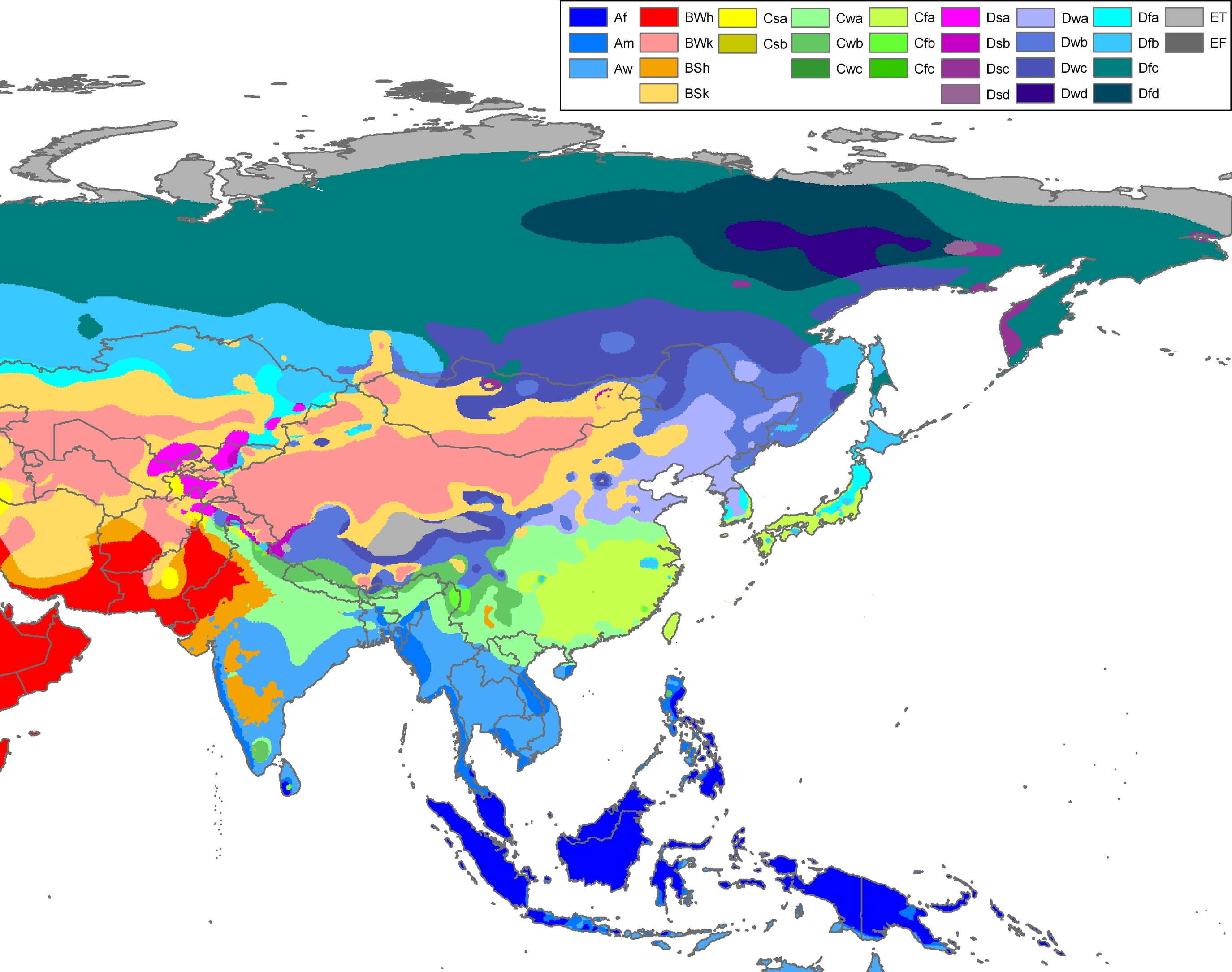
Due to its elongated shape, Inner Mongolia has a four-season monsoon climate with regional variations. The winters in Inner Mongolia are very long, cold, and dry with frequent blizzards, though snowfall is so light that Inner Mongolia has no modern glaciers[2] even on the highest Helan peaks. The spring is short, mild and arid, with large, dangerous sandstorms, whilst the summer is very warm to hot and relatively humid except in the west where it remains dry. Autumn is brief and sees a steady cooling, with temperatures below 0 °C (32 °F) reached in October in the north and November in the south.[citation needed] Officially, most of Inner Mongolia is classified as either a cold arid or steppe regime (Köppen BWk, BSk, respectively). The small portion besides these are classified as humid continental (Köppen Dwa/Dwb) in the northeast, or subarctic (Köppen Dwc) in the far north near Hulunbuir.[41]
Climate crisis
[edit]The region has increasing desertification and frequent sandstorms, which damages agriculture.[42]
| City | July (°C) | July (°F) | January (°C) | January (°F) |
|---|---|---|---|---|
| Baotou | 29.6/17.1 | 85.3/62.8 | −4.1/–16.8 | 24.7/1.8 |
| Bayannur | 30.7/17.9 | 87.3/64.2 | −3.3/–15.1 | 26.1/4.8 |
| Hohhot | 28.5/16.4 | 83.3/61.5 | −5/–16.9 | 23/1.6 |
| Ordos | 26.7/15.8 | 80.1/60.4 | −4.8/–14.7 | 23.4/5.5 |
| Ulanqab | 25.4/13.6 | 77.7/56.5 | −6.1/–18.5 | 21/–1.3 |
Administrative divisions
[edit]Inner Mongolia is divided into twelve prefecture-level divisions. Until the late 1990s, most of Inner Mongolia's prefectural regions were known as leagues (Chinese: 盟), a usage retained from Mongol divisions of the Qing dynasty. Similarly, county-level divisions are often known as banners (Chinese: 旗). Since the 1990s, numerous leagues have been converted into prefecture-level cities, although banners remain. The restructuring led to the conversion of primate cities in most leagues to convert to districts administratively (i.e.: Hailar, Jining and Dongsheng). Some newly founded prefecture-level cities have chosen to retain the original name of league (i.e.: Hulunbuir, Bayannur and Ulanqab), some have adopted the Chinese name of their primate city (Chifeng, Tongliao), and one league (Yekejuu) simply renamed itself Ordos. Despite these recent administrative changes, there is no indication that the Alxa, Hinggan, and Xilingol Leagues will convert to prefecture-level cities in the near future.
| Administrative divisions of Inner Mongolia | ||||||||
|---|---|---|---|---|---|---|---|---|

↖
↗
█ Jiagedaqi Dist. & Songling Dist.
is de jure part of Oroqen Autonomous Banner but de facto subordinate to Daxing'anling Pref., Heilongjiang. | ||||||||
| Division code[43] | Division | Area in km2[44] | Population 2020[45] | Seat | Divisions[46] | |||
| Districts | Counties Banners | Aut. banners | CL cities | |||||
| 150000 | Inner Mongolia Autonomous Region | 1,183,000.00 | 24,049,155 | Hohhot city | 23 | 66 | 3 | 11 |
| 150100 | Hohhot city | 17,186.10 | 3,446,100 | Xincheng District | 4 | 5 | ||
| 150200 | Baotou city | 27,768.00 | 2,709,378 | Jiuyuan District | 6 | 3 | ||
| 150300 | Wuhai city | 1,754.00 | 556,621 | Haibowan District | 3 | |||
| 150400 | Chifeng city | 90,021.00 | 4,035,967 | Songshan District | 3 | 9 | ||
| 150500 | Tongliao city | 59,535.00 | 2,873,168 | Horqin District | 1 | 6 | 1 | |
| 150600 | Ordos city | 86,881.61 | 2,153,638 | Kangbashi District | 2 | 7 | ||
| 150700 | Hulunbuir city | 254,003.79 | 2,242,875 | Hailar District | 2 | 4 | 3 | 5 |
| 150800 | Bayannur city | 65,755.47 | 1,538,715 | Linhe District | 1 | 6 | ||
| 150900 | Ulanqab city | 54,447.72 | 1,706,328 | Jining District | 1 | 9 | 1 | |
| 152200 | Hinggan League | 59,806.00 | 1,416,929 | Ulanhot city | 4 | 2 | ||
| 152500 | Xilingol League | 202,580.00 | 1,107,075 | Xilinhot city | 10 | 2 | ||
| 152900 | Alxa League | 267,574.00 | 262,361 | Alxa Left Banner | 3 | |||
| Administrative divisions in Mongolian, Chinese, and varieties of romanisations | |||||
|---|---|---|---|---|---|
| English | Mongolian | SASM/GNC Mongolian Pinyin | Mongolian Transcription | Chinese | Pinyin |
| Inner Mongolia Autonomous Region |  |
Öbür mongγol-un öbertegen zasaqu orun | 内蒙古自治区 | Nèi Měnggǔ Zìzhìqū | |
| Hohhot city | Hohhot | Kökeqota | 呼和浩特市 | Hūhéhàotè Shì | |
| Baotou city | Bugt Hot | Buɣutu qota | 包头市 | Bāotóu Shì | |
| Wuhai city | Uhai Hot | Üqai qota | 乌海市 | Wūhǎi Shì | |
| Chifeng city | Ulanhad Hot | Ulaɣanqada qota | 赤峰市 | Chìfēng Shì | |
| Tongliao city | Tungliyo Hot | Tüŋliyou qota | 通辽市 | Tōngliáo Shì | |
| Ordos city | Ordos Hot | Ordos qota | 鄂尔多斯市 | È'ěrduōsī Shì | |
| Hulunbuir city | Hulun'buir Hot | Kölön-buyir qota | 呼伦贝尔市 | Hūlúnbèi'ěr Shì | |
| Bayannur city | Bayannur Hot | Bayannaɣur qota | 巴彦淖尔市 | Bāyànnào'ěr Shì | |
| Ulanqab city | Ulanqab Hot | Ulaɣančab qota | 乌兰察布市 | Wūlánchábù Shì | |
| Hinggan League | Hinggan Aimag | Qiŋɣan ayimaɣ | 兴安盟 | Xīng'ān Méng | |
| Xilingol League | Xiliin'gol Aimag | Sili-yin ɣool ayimaɣ | 锡林郭勒盟 | Xīlínguōlè Méng | |
| Alxa League | Alxa Aimag | Alaša ayimaɣ | 阿拉善盟 | Ālāshàn Méng | |
These prefecture-level divisions are in turn subdivided into 102 county-level divisions, including 22 districts, 11 county-level cities, 17 counties, 49 banners, and 3 autonomous banners. Those are in turn divided into 1425 township-level divisions, including 532 towns, 407 townships, 277 sums, eighteen ethnic townships, one ethnic sum, and 190 subdistricts. At the end of 2017, the total population of Inner-Mongolia is 25.29 million.[47]
Urban areas
[edit]| Population by urban areas of prefecture & county cities | ||||
|---|---|---|---|---|
| # | Cities | 2020 Urban area[48] | 2010 Urban area[49] | 2020 City proper |
| 1 | Hohhot | 2,237,249 | 1,497,110 | 3,446,100 |
| 2 | Baotou | 1,949,876 | 1,900,373 | 2,709,378 |
| 3 | Chifeng | 1,093,068 | 902,285 | 4,035,967 |
| 4 | Ordos | 671,048 | 510,242[i] | 2,153,638 |
| 5 | Wuhai | 530,877 | 502,704 | 556,621 |
| 6 | Tongliao | 480,059 | 540,338 | 2,873,168 |
| 7 | Bayannur | 413,117 | 354,507 | 1,538,715 |
| 8 | Ulanqab | 394,269 | 319,723 | 1,706,328 |
| 9 | Hulunbuir | 354,442 | 327,384[ii] | 2,242,875 |
| 10 | Xilinhot | 327,112 | 214,382 | part of Xilingol League |
| 11 | Ulanhot | 318,009 | 276,406 | part of Hinggan League |
| 12 | Yakeshi | 239,742 | 338,275 | see Hulunbuir |
| 13 | Zalantun | 174,049 | 167,493 | see Hulunbuir |
| 14 | Manzhouli | 150,508 | 148,460 | see Hulunbuir |
| 15 | Holingol | 130,239 | 101,496 | see Tongliao |
| 16 | Fengzhen | 122,193 | 123,811 | see Ulanqab |
| 17 | Erenhot | 74,252 | 71,455 | part of Xilingol League |
| 18 | Genhe | 71,164 | 89,194 | see Hulunbuir |
| 19 | Jalainur[iii] | 84,424 | [ii] | see Kunming |
| 20 | Ergun | 54,164 | 55,076 | see Hulunbuir |
| 21 | Arxan | 29,045 | 55,770 | part of Hinggan League |
- ^ New district established after 2010 census: Kangbashi from a part of Dongsheng. The new district is included in the urban area count.
- ^ a b New district established after 2010 census: Jalainur from a part of Manzhouli CLC. The new district not included in the urban area count of the pre-expanded city.
- ^ Jalainur is a satellite urban area separated from Hulunbuir (Hailar) and it is not included in the urban area count.
Most populous cities in Inner Mongolia
Source: China Urban Construction Statistical Yearbook 2018 Urban Population and Urban Temporary Population[50] | |||||||||
|---|---|---|---|---|---|---|---|---|---|
| Rank | Pop. | Rank | Pop. | ||||||
| 1 | Hohhot | 2,364,800 | 11 | Xilinhot | 233,700 | ||||
| 2 | Baotou | 1,936,200 | 12 | Manzhouli | 212,200 | ||||
| 3 | Chifeng | 963,000 | 13 | Fengzhen | 138,600 | ||||
| 4 | Wuhai | 563,300 | 14 | Zalantun | 134,400 | ||||
| 5 | Ordos | 530,400 | 15 | Yakeshi | 131,900 | ||||
| 6 | Tongliao | 460,000 | 16 | Holingol | 130,700 | ||||
| 7 | Bayannur | 383,500 | 17 | Erenhot | 75,200 | ||||
| 8 | Hulunbuir | 350,400 | 18 | Genhe | 64,000 | ||||
| 9 | Ulanqab | 309,600 | 19 | Arxan | 47,800 | ||||
| 10 | Ulanhot | 272,500 | 20 | Ergun | 38,000 | ||||
Economy
[edit]Farming of crops such as wheat takes precedence along the river valleys. In the more arid grasslands, herding of goats, sheep and so on is a traditional method of subsistence. Forestry and hunting are somewhat important in the Greater Khingan ranges in the east. Reindeer herding is carried out by Evenks in the Evenk Autonomous Banner. More recently, growing grapes and winemaking have become an economic factor in the Wuhai area.

Mining-related industries are a major part of Inner Mongolia's economy.[31]: 23 Inner Mongolia has an abundance of resources especially coal, cashmere, natural gas, rare-earth elements, and has more deposits of naturally occurring niobium, zirconium and beryllium than any other province-level region in China. The region is also a source of crude oil, with sites such as the Xifeng oil field producing tens of thousands of barrels per day.[51] However, in the past, the exploitation and utilisation of resources were rather inefficient, which resulted in poor returns from rich resources. Inner Mongolia is also an important coal production base, with more than a quarter of the world's coal reserves located in the province.[52] It plans to double annual coal output by 2010 (from the 2005 volume of 260 million tons) to 500 million tons of coal a year.[53]

Industry in Inner Mongolia has grown up mainly around coal, power generation, forestry-related industries, and related industries. Inner Mongolia now encourages six competitive industries: energy, chemicals, metallurgy, equipment manufacturing, processing of farm (including dairy) produce, and high technology. Well-known Inner Mongolian enterprises include companies such as ERDOS, Yili, and Mengniu. As with much of China, economic growth has led to a boom in construction, including new commercial development and large apartment complexes.
The GDP of Inner Mongolia in 2022 was CN¥2.3 trillion (US$344 billion in nominal),[54] with an average annual increase of 10% from the period 2010–2015. Its per capita GDP was CN¥96,474 (US$14,343 in nominal), ranking 8th among all the 31 provincial divisions of China.[54] The primary, secondary and tertiary industries contributed ¥265 billion ($39.45 billion), ¥1.12 trillion ($167.1 billion) and ¥926 billion ($137.7 billion) to the GDP respectively.[54]
In addition to its large reserves of natural resources, Inner Mongolia also has the largest usable wind power capacity in China[52] thanks to strong winds which develop in the province's grasslands. Some private companies have set up wind parks in parts of Inner Mongolia such as Bailingmiao, Hutengliang and Zhouzi.
East of Jilantai, Inner Mongolia, there is a ballistic missile training area used by the People's Liberation Army Rocket Force (PLARF) to train missile crews for mobile missile launchers, their support vehicles, and silo-based ballistic missiles.[55]
Economic and Technological Development Zones
[edit]- Baotou National Rare-Earth Hi-Tech Industrial Development Zone[56]
- Erenhot Border Economic Cooperation Area
- Hohhot Export Processing Zone
Hohhot Export Processing Zone was established 21 June 2002 by the State Council, which is located in the west of the Hohhot, with a planning area of 2.2 km2 (0.85 sq mi). Industries encouraged in the export processing zone include Electronics Assembly & Manufacturing, Telecommunications Equipment, Garment and Textiles Production, Trading and Distribution, Biotechnology/Pharmaceuticals, Food/Beverage Processing, Instruments & Industrial Equipment Production, Medical Equipment and Supplies, Shipping/Warehousing/Logistics, Heavy Industry.[57]
- Hohhot Economic and Technological Development Zone
- Hohhot Export Processing Zone
- Manzhouli Border Economic Cooperation Area
Transport
[edit]Railway
[edit]Lines wholly or partly in Inner Mongolia include:
- Beijing–Baotou railway (Jingbao railway)
- Baotou–Lanzhou railway
- Beijing–Tongliao railway
- Harbin–Manzhouli railway
- Jiayuguan–Ceke railway
- Jining–Tongliao railway
- Linhe–Ceke railway
- Nenjiang–Greater Khingan Forest railway
- Tongliao–Ranghulu railway
Railway stations in Inner Mongolia include:
Government and politics
[edit]Under the Constitution of the People's Republic of China, articles 112–122, autonomous regions have limited autonomy in both the political and economic arena. Autonomous regions have more discretion in administering economic policy in the region in accordance with national guidelines. Structurally, the Chairman—who legally must be an ethnic minority and is usually ethnic Mongolian—is always kept in check by the Communist Party Regional Committee Secretary, who is usually from a different part of China (to reduce corruption) and Han Chinese. As of May 2023[update], the current party secretary is Sun Shaocheng. The Inner Mongolian government and its subsidiaries follow roughly the same structure as that of a Chinese province. With regards to economic policy, as a part of increased federalism characteristics in China, Inner Mongolia has become more independent in implementing its own economic roadmap.
The position of Chairman of Inner Mongolia alternates between Khorchin Mongols in the east and the Tumed Mongols in the west.[citation needed] Since the end of the Cultural Revolution, this convention has not been broken. The family of Ulanhu has retained influence in regional politics ever since the founding the People's Republic. His son Buhe and granddaughter Bu Xiaolin both served as Chairman of the region.
Demographics
[edit]
| Year | Pop. | ±% p.a. |
|---|---|---|
| 1954[58] | 6,100,104 | — |
| 1964[59] | 12,348,638 | +7.31% |
| 1982[60] | 19,274,279 | +2.50% |
| 1990[61] | 21,456,798 | +1.35% |
| 2000[62] | 23,323,347 | +0.84% |
| 2010[63] | 24,706,321 | +0.58% |
| 2020[64] | 24,049,155 | −0.27% |
| Established in 1947 from dissolution of Xing'an Province, Qahar Province, parts of Rehe Province, and Suiyuan Province; parts of Ningxia Province were incorporated into Inner Mongolia AR. | ||
.svg)
When the autonomous region was established in 1947, Han Chinese comprised 83.6% of the population, while the Mongols comprised 14.8% of the population.[65] By 2020, the percentage of Han Chinese had dropped to 78.7%. While the Hetao region along the Yellow River has always alternated between farmers from the south and nomads from the north, the most recent wave of Han Chinese migration began in the early 18th century with encouragement from the Qing dynasty, and continued into the 20th century. Han Chinese live mostly in the Hetao region as well as various population centres in central and eastern Inner Mongolia. Over 70% of Mongols are concentrated in less than 18% of Inner Mongolia's territory (Hinggan League, and the prefectures of Tongliao and Chifeng).
Mongols are the second largest ethnic group, comprising 17.7% of the population as of the 2020 census.[8] They include many diverse Mongolian-speaking groups; groups such as the Buryats and the Oirats are also officially considered to be Mongols in China. In addition to the Manchus, other Tungusic ethnic groups, the Oroqen, and the Evenks also populate parts of northeastern Inner Mongolia. There is also a significant number of Hui and Koreans.
Many of the traditionally nomadic Mongols have settled in permanent homes as their pastoral economy was collectivised during the Mao era, and some have taken jobs in cities as migrant labourers; however, some Mongols continue in their nomadic tradition. In practice, highly educated Mongols tend to migrate to big urban centers after which they become essentially indistinct with ethnic Han Chinese populations.
Inter-marriage between Mongol and non-Mongol populations is very common, particularly in areas where Mongols are in regular contact with other groups. There was little cultural stigma within Mongol families for marrying outside the ethnic group, and in urban centers in particular, Mongol men and women married non-Mongols at relatively similar rates. The rates of intermarriage stands in very sharp contrast to ethnic Tibetans and Uyghurs in their respective autonomous regions. By the 1980s, for instance, in the former Jirim League, nearly 40% of marriages with at least one Mongol spouse was a mixed Mongol-Han Chinese marriage.[66] However, anecdotal reports have also demonstrated an increase in Mongol-female, Han Chinese-male pairings in which the woman is of a rural background, ostensibly shutting rural Mongol males from the marriage market as the sex ratio in China becomes more skewed with a much higher proportion of men.[67]
| Ethnicity | Population | Percentage |
|---|---|---|
| Han | 19,650,687 | 79.54% |
| Mongol | 4,226,093 | 17.11% |
| Manchu | 452,765 | 1.83% |
| Daur | 121,483 | 0.49% |
| Evenks | 26,139 | 0.11% |
| Oroqen people | 8,464 | 0.07% |
| Year | Population | Han Chinese | Mongol | Manchu | |||
|---|---|---|---|---|---|---|---|
| 1953[69] | 6,100,104 | 5,119,928 | 83.9% | 888,235 | 14.6% | 18,354 | 0.3% |
| 1964[69] | 12,348,638 | 10,743,456 | 87.0% | 1,384,535 | 11.2% | 50,960 | 0.4% |
| 1982[69] | 19,274,281 | 16,277,616 | 84.4% | 2,489,378 | 12.9% | 237,149 | 1.2% |
| 1990[70] | 21,456,500 | 17,290,000 | 80.6% | 3,379,700 | 15.8% | ||
| 2000[71] | 23,323,347 | 18,465,586 | 79.2% | 3,995,349 | 17.1% | 499,911 | 2.3% |
| 2010[72] | 24,706,321 | 19,650,687 | 79.5% | 4,226,093 | 17.1% | 452,765 | 1.83% |
| 2020[8] | 24,049,155 | 18,935,537 | 78.7% | 4,247,815 | 17.7% | ||
| Name of banner | Mongol population | Percentage |
|---|---|---|
| Horqin Right Middle Banner, Hinggan (2020)[73] | 221,258 | 86.6% |
| New Barag Right Banner, Hulunbuir (2009) | 28,369 | 82.2% |
| Horqin Left Back Banner, Tongliao | 284,000 | 75% |
| New Barag Left Banner, Hulunbuir (2009) | 31,531 | 74.9% |
| Horqin Left Middle Banner, Tongliao | 395,000 | 73.5% |
| East Ujimqin Banner, Xilingol (2009) | 43,394 | 72.5% |
| West Ujimqin Banner, Xilingol | 57,000 | 65% |
| Sonid Left Banner, Xilingol (2006) | 20,987 | 62.6% |
| Bordered Yellow Banner, Xilingol | 19,000 | 62% |
| Hure Banner, Tongliao | 93,000 | 56% |
| Jarud Banner, Tongliao | 144,000 | 48% |
| Horqin Right Front Banner, Hinggan | 162,000 | 45% |
| Old Barag Banner, Hulunbuir (2006) | 25,903 | 43.6% |
| Jalaid Banner, Hinggan | 158,000 | 39% |
| Ar Khorchin Banner, Chifeng (2002) | 108,000 | 36.6% |
Language and culture
[edit]


The use of Mongolian by Inner Mongolia's 4.1 million ethnic Mongols has sharply declined since the 1980s.[74] Across the whole of China, the language is spoken by roughly half of the country's 5.8 million ethnic Mongols (2005 estimate).[75] However, the exact number of Mongolian speakers in China is unknown, as there is no data available on the language proficiency of that country's citizens. The use of Mongolian in China, specifically in Inner Mongolia, has witnessed periods of decline and revival over the last few hundred years. The language experienced a decline during the late Qing period, a revival between 1947 and 1965, a second decline between 1966 and 1976, a second revival between 1977 and 1992, and a third decline between 1995 and 2012.[76] However, in spite of the decline of the Mongolian language in some of Inner Mongolia's urban areas and educational spheres, the ethnic identity of the urbanised Chinese-speaking Mongols is most likely going to survive due to the presence of urban ethnic communities.[77] The multilingual situation in Inner Mongolia does not appear to obstruct efforts by ethnic Mongols to preserve their language.[78][79] Although an unknown number of Mongols in China, such as the Tumets, may have completely or partially lost the ability to speak their language, they are still registered as ethnic Mongols and continue to identify themselves as ethnic Mongols.[75][80] The children of inter-ethnic Mongol-Chinese marriages also claim to be and are registered as ethnic Mongols.[81]
By law, all street signs, commercial outlets, and government documents must be bilingual, written in both Mongolian and Chinese. There are three Mongolian TV channels in the Inner Mongolia Satellite TV network. In public transportation, all announcements are to be bilingual.
Mongols in Inner Mongolia speak Mongolian dialects such as Chakhar, Xilingol, Baarin, Khorchin and Kharchin Mongolian and, depending on definition and analysis, further dialects[82] or closely related independent Central Mongolic languages[83] such as Ordos, Khamnigan, Barghu Buryat and the arguably Oirat dialect Alasha. The standard pronunciation of Mongolian in China is based on the Chakhar dialect of the Plain Blue Banner, located in central Inner Mongolia, while the grammar is based on all Inner Mongolian dialects.[84] This is different from the Mongolian state, where the standard pronunciation is based on the closely related Khalkha dialect. There are a number of independent languages spoken in Hulunbuir such as the somewhat more distant Mongolic language Dagur and the Tungusic language Evenki. Officially, even the Evenki dialect Oroqin is considered a language.[85]
The Han Chinese of Inner Mongolia speak a variety of dialects, depending on the region. Those in the eastern parts tend to speak Northeastern Mandarin, which belongs to the Mandarin group of dialects; those in the central parts, such as the Yellow River valley, speak varieties of Jin, another subdivision of Chinese, due to its proximity to other Jin-speaking areas in China such as the Shanxi province. Cities such as Hohhot and Baotou both have their unique brand of Jin Chinese such as the Zhangjiakou–Hohhot dialect which are sometimes incomprehensible with dialects spoken in northeastern regions such as Hailar.
The vast grasslands have long symbolised Inner Mongolia. Mongolian art often depicts the grassland in an uplifting fashion and emphasises Mongolian nomadic traditions. The Mongols of Inner Mongolia still practice their traditional arts. Inner Mongolian cuisine has Mongol roots and consists of dairy-related products and hand-held lamb (手扒肉). In recent years, franchises based on hot pot have appeared in Inner Mongolia, the best known of which is Little Sheep. Notable Inner Mongolian commercial brand names include Mengniu and Yili, both of which began as dairy product and ice cream producers.
Among the Han Chinese of Inner Mongolia, Shanxi opera is a popular traditional form of entertainment. See also: Shanxi. A popular career in Inner Mongolia is circus acrobatics. The internationally known Inner Mongolia Acrobatic Troupe travels and performs with the renowned Ringling Bros. and Barnum & Bailey Circus.
Religion
[edit]
According to a survey held in 2004 by the Minzu University of China, about 80% of the population of the region practice the worship of Heaven (that is named Tian in the Chinese tradition and Tenger in the Mongolian tradition) and of ovoo/aobao.[86]
Official statistics report that 10.9% of the population (3 million people) are members of Tibetan Buddhist groups.[87] According to the Chinese Spiritual Life Survey of 2007 and the Chinese General Social Survey of 2009, Christianity is the religious identity of 3.2% of the population of the region and Chinese ancestral religion that of 2.36%,[88] while a demographic analysis of the year 2010 reported that Muslims make up 0.91%.[89]
The cult of Genghis Khan, present in the form of various Genghis Khan temples, is a tradition of Mongolian shamanism, in which he is considered a cultural hero and divine ancestor, an embodiment of the Tenger (Heaven, God of Heaven).[90] His worship in special temples, greatly developed in Inner Mongolia since the 1980s, is also shared by the Han Chinese, claiming his spirit as the founding principle of the Yuan dynasty.[91]
Tibetan Buddhism (Mongolian Buddhism, locally also known as "Yellow Buddhism") is the dominant form of Buddhism in Inner Mongolia, also practised by many Han Chinese. Another form of Buddhism, practised by the Chinese, are the schools of Chinese Buddhism.
Tourism
[edit]In the capital city Hohhot:
- Da Zhao Temple is a Buddhist temple built in 1580. Dazhao Temple is known for three sites: a statue of Buddha made from silver, elaborate carvings of dragons, and murals.
- Five-pagoda Temple is located in the capital of Inner Mongolia Hohhot. It is also called Jingangzuo Dagoba, used to be one building of the Cideng Temple (Temple of Merciful Light) built in 1727.
- Residence of Gurun Princess Kejing is a mansion typical of Qing dynasty architectural style that was built in 1705 by the Kangxi Emperor for his daughter.
- Wanbu-Huayanjing Pagoda (万部华严经塔) in Hohhot. It was built during the reign of Emperor Shengzong (983–1031) of the Khitan Liao dynasty (907–1125) and is still well preserved.
- Xiaozhao Temple, also known as Chongfu temple, is a Buddhist temple built in 1697 and favoured by the Kangxi Emperor of the Qing dynasty.
- Xilitu Zhao / Siregtu juu Temple is the largest Buddhist temple in the Höhhot area, and once the center of power of Tibetan Buddhism in the region.
- Zhaojun Tomb is the tomb of Wang Zhaojun, a Han dynasty palace lady-in-waiting who became the consort of the Xiongnu ruler Huhanye Shanyu in 33BC.
Elsewhere in Inner Mongolia:
- Baotou's urban grassland, Saihantala, with elevations ranging from 1,034 to 1,058 meters, features yurts, god hills, wrestling, and horse racing activities.
- The Mausoleum of Genghis Khan, the cenotaph of Genghis Khan, is located in Ordos City.
- Bashang Grasslands, on the border close to Beijing, is a popular retreat for urban residents wanting to get a taste of grasslands life.
- The Arshihaty Stone Forest in Hexigten Global Geopark has magnificent granite rock formations formed from natural erosion.
- Xiangshawan, or "singing sands gorge", is located in the Gobi Desert and contains numerous tourist attractions including sand sledding and camel rides.
- Remains of Zhongjing (Central Capital) built in 1003 by Emperor Shengzong of the Khitan Liao dynasty (907–1125) in Ningcheng County.
- Remains of Shangjing (Upper Capital) built in 918 by Yelu Abaoji the 1st emperor of the Khitan Liao dynasty (907–1125). Also called Huangdu it was one of the five capitals of the Liao dynasty.
- Zuling Mausoleum of Abaoji Khan. It was built in 926 for Abaoji the 1st Emperor of the Liao dynasty. Located north-west of Shifangzi village.
- Tablets of Juyan. Han dynasty (206 BC – 220 AD) inscriptions on wood and bamboo. In 1930 Folke Bergman of the Sino-Swedish expedition first discovered 10,000 tablets at Ejin Khoshuu in the Gobi Desert.
- Ruins of Shangdu (Xanadu) the Summer Capital of the Mongol Yuan dynasty built in 1256 by Kublai Khan.
- White pagoda of the Mongol Yuan dynasty (1279–1368) in Kailu County, Tongliao. It is still well preserved.
- Ruins of Chagan Khoto (查干浩特) capital of the last Mongol Great Khan Ligden (1588–1634). Located in Ar Horqin Banner.

One of China's space vehicle launch facilities, Jiuquan Satellite Launch Center, is located in the Alxa League's Ejin Banner, in the west of Inner Mongolia. It was founded in 1958, making it the PRC's first launch facility. As of 2021, Jiuquan has documented more launches than any other launch facilities in China, and is still the only launch site for crewed space missions (Shenzhou program). While geologically located inside Inner Mongolia, the launch center is named after Jiuquan, which is the nearest urban center in the nearby province of Gansu. As military facilities, the core areas at Jiuquan Center are highly restricted and can only be visited by tourist buses operated by the center, while the visitor center is open to the public and can be accessed from the south gate.
Inner Mongolia is also home to the two (and only two) space vehicles landing sites in China, the Siziwang Banner Landing Site in Ulanqab and the Dongfeng Landing Site in Alxa.
Education
[edit]Colleges and universities
[edit]Language policy and protest
[edit]Inner Mongolia under the People's Republic of China has historically allowed the Mongolian language as a medium of instruction. A 1979 article from the People's Daily praises the re-establishment of Mongolian-language education after "interference and vandalism by the Gang of Four" during the Cultural Revolution.[92]
It was reported by The New York Times on 31 August 2020 that in the summer 2020, the Chinese government announced a new education policy, which called for Chinese to gradually replace Mongolian as the language of instruction in three subjects, including language and literature, politics, and history, in elementary and middle schools around the Inner Mongolia region. Thousands of ethnic Mongolians in northern China gathered to protest the policy.[93]
Image gallery
[edit]-
 Ulaanbutan grassland
 -
 Inner Mongolian grassland
 -
 Helan Mountains scenery
 -
 Khitan people cooking. Fresco from the Liao dynasty (907–1125) tomb in Aohan Banner
 -
 Fresco from the Liao dynasty (907–1125) tomb at Baoshan, Ar Horqin Banner
 -
 Honorary tomb of Wang Zhaojun (born c. 50BC) in Hohhot
 -

-

-
 Newly built arch in front of the Maidari Juu temple fortress (1575)
 -
 Dazhao temple (also called Ikh Zuu) built by Altan Khan in 1579
 -
 Five Pagoda temple (1727) in Hohhot
 -
 Badekar Monastery (1749) near Baotou, Inner Mongolia. Called Badgar Zuu in Mongolian
 -
 Badain Jaran temple (1868) in Alxa Right Banner, western Inner Mongolia
 -
 Alxa Western Monastery (Alshaa Baruun Hiid) built in 1756
 -
 Genghis Khan Mausoleum (1954) in Ejin Horo Banner
 -
 Genghis Khan Mausoleum (1954)

.jpg)


See also
[edit]Notes
[edit]- ^
- Also known as Öbhör Mongol or Nei Mongol
- Chinese: 内蒙古; pinyin: Nèi Měnggǔ
- Mongolian: ᠥᠪᠥᠷᠮᠣᠩᠭᠣᠯ, pronounced [ˈɵw̜ʊ̈r ˈmɔɴɢɜ̆ɮ]
- ^
- Chinese: 内蒙古自治区; pinyin: Nèiměnggǔ Zìzhìqū
- Mongolian: ᠥᠪᠥᠷᠮᠣᠩᠭᠣᠯ ᠤᠨᠥᠪᠡᠷᠲᠡᠭᠨᠵᠠᠰᠠᠬᠤᠣᠷᠣᠨ, pronounced [ˈɵw̜ʊ̈r ˌmɔɴɢɜ̆ˈɮiːɴ ˈoːr̥tʰoː ˈt͡sasəχ ˈɔɾɞɴ]
- ^ The provinces of the State of Mongolia in Outer Mongolia that border Inner Mongolia are, from east to west, Dornod, Sükhbaatar, Dornogovi, Ömnögovi, Bayankhongor, and Govi-Altai
- ^ The White Sulde (White Spirit) is one of the two spirits of Genghis Khan (the other being the Black Sulde), represented either as his white or yellow horse or as a fierce warrior riding this horse. In its interior, the temple enshrines a statue of Genghis Khan (at the center) and four of his men on each side (the total making nine, a symbolic number in Mongolian culture), there is an altar where offerings to the godly men are made, and three white suldes made with white horse hair. From the central sulde there are strings which hold tied light blue pieces of cloth with a few white ones. The wall is covered with all the names of the Mongol kins. The Chinese worship Genghis as the ancestral god of the Yuan dynasty.
References
[edit]- ^ "Doing Business in China Survey". Ministry Of Commerce – People's Republic Of China. Archived from the original on 5 August 2013. Retrieved 5 August 2013.
- ^ a b c Wei Zhang, Mingyue He, Yonghua Li, Zhijiu Cui, Zhilin Wang and Yang Yu; "Quaternary glacier development and the relationship between the climate change and tectonic uplift in the Helan Mountains" Archived 14 June 2017 at the Wayback Machine; in Chinese Science Bulletin; December 2012, Volume 57, Issue 34, pp. 4491–4504.
- ^ "Communiqué of the Seventh National Population Census (No. 3)". National Bureau of Statistics of China. 11 May 2021. Retrieved 11 May 2021.
- ^ "China". Ethnologue.
- ^ "National Data". China NBS. March 2024. Retrieved 22 June 2024. see also "zh: 内蒙古自治区2023年国民经济和社会发展统计公报" (in Chinese). neimenggu.gov.cn. 21 March 2024. Retrieved 12 June 2022. The average exchange rate of 2023 was CNY 7.0467 to 1 USD dollar "Statistical communiqué of the People's Republic of China on the 2023 national economic and social development" (Press release). China NBS. 29 February 2024. Retrieved 22 June 2024.
- ^ "Human Development Indices (8.0)- China". Global Data Lab. Retrieved 23 September 2024.
- ^ "Tabulation on the 2010 Population Census of the People's Republic of China". stats.gov.cn. Archived from the original on 7 July 2013. Retrieved 7 May 2013.
- ^ a b c "内蒙古自治区第七次全国人口普查公报(第一号)-第七次全国人口普查-内蒙古自治区统计局". tj.nmg.gov.cn. Archived from the original on 4 August 2022. Retrieved 5 October 2021.
- ^ "China's push to create a single national identity". The Economist. 14 September 2023.
- ^ Borjigin, Huhbator (2004). "The history and political character of the name of 'Nei Menggu' (South Mongolia)". Inner Asia (6): 61–80. doi:10.1163/146481704793647207.
- ^ History of Mongolia, Volume I, 2003.
- ^ Records of the Grand Historian by Sima Qian.
- ^ CPAtwood-Encyclopedia of Mongolia and the Mongol Empire, p. 246.
- ^ Atwood, Christopher. Encyclopedia of Mongolia and the Mongol Empire, p. 449.
- ^ Reardon-Anderson, James (October 2000). "Land Use and Society in Manchuria and Inner Mongolia during the Qing Dynasty". Environmental History. 5 (4): 503–530. Bibcode:2000EnvH....5..503R. doi:10.2307/3985584. JSTOR 3985584. S2CID 143541438.
- ^ Bulag 2012 Archived 2 November 2022 at the Wayback Machine, p. 41.
- ^ Charleux, Isabelle (2015). Nomads on Pilgrimage: Mongols on Wutaishan (China), 1800–1940. BRILL. p. 15. ISBN 978-90-04-29778-4.
- ^ The Cambridge History of China. Vol. 10. Cambridge University Press. 1978. p. 356.
- ^ Tsai, Wei-chieh (June 2017). Mongolization of Han Chinese and Manchu Settlers in Qing Mongolia, 1700–1911 (PDF) (Doctor of Philosophy in the Department of Central Eurasian Studies, Indiana University). ProQuest LLC. p. 7.
- ^ Liu, Xiaoyuan (2006). Reins of Liberation: An Entangled History of Mongolian Independence, Chinese Territoriality, and Great Power Hegemony, 1911–1950 (illustrated ed.). Stanford University Press. p. 117. ISBN 0-8047-5426-8.
- ^ Borjigin, Burensain (2004). "The Complex Structure of Ethnic Conflict in the Frontier: Through the Debates around the 'Jindandao Incident' in 1891". Inner Asia. 6 (1): 41–60. doi:10.1163/146481704793647171. JSTOR 23615320.
- ^ Atwood, Christopher. The Encyclopedia of Mongolia and the Mongol Empire, p. 454.
- ^ Atwood, Christopher. The Encyclopedia of Mongolia and the Mongol Empire, p. 91,
- ^ Belov, E. A. Anti-Chinese rebellion led by Babujav in Inner Mongolia, 1915–1916. – Annaly (Moscow), no. 2, 1996.
- ^ Belov, E. A. Rossiya i Mongoliya (1911–1919). Moscow: Vost. Lit. Publ.
- ^ a b Lin, Hsiao-ting (13 September 2010). "4 War and new frontier designs". Modern China's Ethnic Frontiers: A Journey to the West. Routledge Studies in the Modern History of Asia. Routledge. pp. 65–66. ISBN 978-1-136-92393-7.
- ^ Lin, Hsiao-ting (13 September 2010). "4 War and new frontier designs". Modern China's Ethnic Frontiers: A Journey to the West. Routledge Studies in the Modern History of Asia. Routledge. pp. 136–. ISBN 978-1-136-92392-0.
- ^ Lin, Hsiao-ting (13 September 2010). "4 War and new frontier designs". Modern China's Ethnic Frontiers: A Journey to the West. Routledge Studies in the Modern History of Asia. Routledge. p. 137. ISBN 978-1-136-92392-0. Archived from the original on 10 November 2018. Retrieved 24 May 2018.
- ^ David Sneath, "The Impact of the Cultural Revolution in China on the Mongolians of Inner Mongolia", in Modern Asian Studies, Vol. 28, No. 2 (May 1994), pp. 409–430.
- ^ Dikötter, Frank (2016). The Cultural Revolution: A People's History, 1962–1976 (1st U.S. ed.). New York: Bloomsbury Publishing USA. p. 191. ISBN 978-1-63286-422-2.
- ^ a b Zhan, Jing Vivian (2022). China's Contained Resource Curse: How Minerals Shape State-Capital-Labor Relations. Cambridge, United Kingdom: Cambridge University Press. ISBN 978-1-009-04898-9.
- ^ Zhang, Chi Chi (19 April 2012). "Ethnic Mongolians in China concerned about cultural threat". CNN. Archived from the original on 2 April 2015. Retrieved 24 March 2015.
- ^ "Ordos, China: A Modern Ghost Town". Time. Archived from the original on 24 March 2015. Retrieved 24 March 2015.
- ^ Day, Peter (17 March 2012). "Ordos: The biggest ghost town in China". BBC News. Archived from the original on 24 June 2018. Retrieved 21 June 2018.
- ^ Shepard, Wade. "China's Most Infamous 'Ghost City' Is Rising From The Desert". Forbes. Retrieved 29 March 2025.
- ^ "Inner Mongolians culture clash". CNN. 18 April 2012. Archived from the original on 2 April 2015. Retrieved 24 March 2015.
- ^ "China Launches 'Strike Hard' Anti-Rumor Campaign in Inner Mongolia". Radio Free Asia. 5 September 2013. Archived from the original on 2 April 2015.
- ^ Gerry Shih (31 August 2020). "Chinese authorities face widespread anger in Inner Mongolia after requiring Mandarin-language classes". The Washington Post. Retrieved 1 September 2020.
- ^ Amy Qin (31 August 2020). "Curbs on Mongolian Language Teaching Prompt Large Protests in China". The New York Times. Retrieved 1 September 2020.
- ^ Qiao Long (31 August 2020). Luisetta Mudie (ed.). "Mass Protests Erupt as China Moves to End Mongolian-Medium Teaching in Schools". Radio Free Asia. Translated by Luisetta Mudie. Retrieved 1 September 2020.
- ^ Peel, M. C. and Finlayson, B. L. and McMahon, T. A. (2007). "Updated world map of the Köppen-Geiger climate classification" Archived 22 November 2011 at the Wayback Machine. Hydrology and Earth System Sciences 11: 1633–1644.
- ^ Han, Jie; Dai, Han; Gu, Zhaolin (2021). "Sandstorms and desertification in Mongolia, an example of future climate events: a review". Environmental Chemistry Letters. 19 (6): 4063–4073. Bibcode:2021EnvCL..19.4063H. doi:10.1007/s10311-021-01285-w. ISSN 1610-3653. PMC 8302971. PMID 34335128.
- ^ 中华人民共和国县以上行政区划代码 (in Simplified Chinese). Ministry of Civil Affairs. Archived from the original on 2 April 2015. Retrieved 7 April 2015.
- ^ Shenzhen Statistical Bureau. 《深圳统计年鉴2014》 (in Simplified Chinese). China Statistics Print. Archived from the original on 12 May 2015. Retrieved 29 May 2015.
- ^ Census Office of the State Council of the People's Republic of China; Population and Employment Statistics Division of the National Bureau of Statistics of the People's Republic of China (2012). 中国2010人口普查分乡、镇、街道资料 (1 ed.). Beijing: China Statistics Print. ISBN 978-7-5037-6660-2.
- ^ Ministry of Civil Affairs (August 2014). 《中国民政统计年鉴2014》 (in Simplified Chinese). China Statistics Print. ISBN 978-7-5037-7130-9.
- ^ "中国统计年鉴—2018".
- ^ 国务院人口普查办公室、国家统计局人口和社会科技统计司编 (2022). 中国2020年人口普查分县资料. Beijing: China Statistics Print. ISBN 978-7-5037-9772-9.
- ^ 国务院人口普查办公室、国家统计局人口和社会科技统计司编 (2012). 中国2010年人口普查分县资料. Beijing: China Statistics Print. ISBN 978-7-5037-6659-6.
- ^ Ministry of Housing and Urban-Rural Development of the People's Republic of China(MOHURD) (2019). 中国城市建设统计年鉴2018 [China Urban Construction Statistical Yearbook 2018] (in Chinese). Beijing: China Statistic Publishing House. Archived from the original on 10 August 2021. Retrieved 30 November 2021.
- ^ "PetroChina Xifeng Oilfield Reserves Hits 568mn Tons". tmcnet.com. 2007. Archived from the original on 19 October 2014. Retrieved 27 May 2013.
- ^ a b "China Economy @ China Perspective". thechinaperspective.com. Archived from the original on 26 September 2011.
- ^ "People's Daily Online – Inner Mongolia to double annual coal output by 2010". people.com.cn. Archived from the original on 27 June 2006. Retrieved 5 February 2006.
- ^ a b c "National Data". neimenggu.gov.cn. 21 March 2024. Retrieved 12 June 2022.
- ^ Kristensen, Hans (24 February 2021). "China's Expanding Missile Training Area: More Silos, Tunnels, and Support Facilities". The Federation of American Scientists. Retrieved 25 August 2021.
- ^ Baotou National Rare-Earth Hi-Tech Industrial Development Zone Archived 16 October 2015 at the Wayback Machine.
- ^ RightSite.asia | Hohhot Export Processing Zone.
- ^ 中华人民共和国国家统计局关于第一次全国人口调查登记结果的公报 (in Chinese). National Bureau of Statistics of China. Archived from the original on 5 August 2009.
- ^ 第二次全国人口普查结果的几项主要统计数字 [Some major statistics on the results of the second national census] (in Chinese). National Bureau of Statistics of China. Archived from the original on 14 September 2012.
- ^ 中华人民共和国国家统计局关于一九八二年人口普查主要数字的公报 [The Bulletin of the National Bureau of Statistics of the People's Republic of China on the Major Figures of the 1982 Population Census] (in Chinese). National Bureau of Statistics of China. Archived from the original on 10 May 2012.
- ^ 中华人民共和国国家统计局关于一九九〇年人口普查主要数据的公报 (in Chinese). National Bureau of Statistics of China. Archived from the original on 19 June 2012.
- ^ 现将2000年第五次全国人口普查快速汇总的人口地区分布数据公布如下 (in Chinese). National Bureau of Statistics of China. Archived from the original on 29 August 2012.
- ^ "Communiqué of the National Bureau of Statistics of People's Republic of China on Major Figures of the 2010 Population Census" (in Chinese). National Bureau of Statistics of China. Archived from the original on 27 July 2013.
- ^ "FACTBOX-Key takeaways from China's 2020 population census". Reuters. 11 May 2021.
- ^ Myron Weiner, Sharon Stanton Russell(2001). Demography and national security. page 276, table 9.4.
- ^ Mongolia in the Twentieth Century. New York City: Rutledge. 1999. p. 213.
- ^ He, Shenghai; Eade, John (May 2015). "Unequal Marriage Exchange Between Majority and Minority Groups: A Case Study From Inner Mongolia, China" (PDF). Sociology Study. Archived (PDF) from the original on 29 July 2018. Retrieved 16 August 2016.
- ^ 《2010年人口普查中国民族人口资料》 [Tabulation on Nationalities of 2010 Population Census of China]. Beijing: Nationalities Publishing House (民族出版社). 2003. ISBN 978-7-105-05425-1.
- ^ a b c (without Rehe) 《中华人民共和国人口统计资料汇编1949—1985》 [People's Republic of demographic data compilation 1949–1985]. China Financial and Economic Publishing House (中国财政经济出版社). 1988. p. 924.
- ^ 1990年第四次人口普查 [4th National Census]. Inner Mongolia Autonomous Region Bureau of Statistics. Archived from the original on 27 July 2013. Retrieved 4 June 2013..
- ^ National Bureau of Population and Social Science and Technology Statistics Division of China (国家统计局人口和社会科技统计司); Department of Economic Development of the State Ethnic Affairs Commission of China (国家民族事务委员会经济发展司) (2003). 《2000年人口普查中国民族人口资料》 (in Chinese (China)). Beijing: Publishing House of Minority Nationalities. pp. 4–8. ISBN 978-7-105-05425-1.
- ^ 内蒙古自治区发布2010年第六次全国人口普查主要数据公报. Archived from the original on 12 July 2013. Retrieved 4 June 2013.
- ^ 人口民族. Horqin Right Middle Banner People's Government (in Chinese). 24 April 2020. Archived from the original on 9 July 2020. Retrieved 9 July 2020.
- ^ Tsung, Linda (27 October 2014). "Maintaining the Mongolian Language in Inner Mongolia". Language Power and Hierarchy: Multilingual Education in China. Bloomsbury Academic. p. 59.
- ^ a b Janhunen, Juha (29 November 2012). "1". Mongolian. John Benjamins Publishing Company. p. 11.
- ^ Tsung, Linda (27 October 2014). "3". Language Power and Hierarchy: Multilingual Education in China. Bloomsbury Academic.
- ^ Iredale, Robyn; Bilik, Naran; Fei, Guo (2 August 2003). "4". China's Minorities on the Move: Selected Case Studies. p. 84.
- ^ Janhunen, Juha (29 November 2012). "1". Mongolian. John Benjamins Publishing Company. p. 16.
- ^ Otsuka, Hitomi (30 November 2012). "6". More Morphologies: Contributions to the Festival of Languages, Bremen, 17 Sep to 7 Oct, 2009. p. 99.
- ^ Iredale, Robyn (2 August 2003). "3". China's Minorities on the Move: Selected Case Studies. Routledge. pp. 56, 64–67.
- ^ Janhunen, Juha (29 November 2012). "1". Mongolian. John Benjamins Publishing Company. p. 11.Iredale, Robyn; Bilik, Naran; Fei, Guo (2 August 2003). "3". China's Minorities on the Move: Selected Case Studies. p. 61.
- ^ e.g. Sečenbaγatur, Qasgerel, Tuyaγ-a, B. ǰirannige, U Ying ǰe. 2005. Mongγul kelen-ü nutuγ-un ayalγun-u sinǰilel-ün uduridqal. Kökeqota: ÖMAKQ.
- ^ e.g. Janhunen, Juha. 2006. Mongolic languages. In: Brown, K. (ed.): The encyclopedia of language & linguistics. Amsterdam: Elsevier: 231–234.
- ^ Sečenbaγatur et al. 2005: 85.
- ^ Janhunen, Juha. 1997. The languages of Manchuria in today's China. In: Northern Minority languages: Problems of survival. Senri ethnological studies, 44: 123–146. See pages 130–133.
- ^ Fenggang Yang, Graeme Lang. Social Scientific Studies of Religion in China. BRILL, 2012. ISBN 90-04-18246-2. pp. 184–185, reporting the results of surveys held in 2004 by the Minzu University of China. Quote from page 185: «[...] the registered adherents of the five official religions comprise only 3.7% of those [populations] in Inner Mongolia. When we compare this final statistic with Minzu University research team's finding that 80% of the inhabitants of Inner Mongolia worship Tian (loosely translated "Heaven") and aobao (traditional stone structures that serve as altars for sacrifice), it is evident that the official calculations of registered religious believers are markedly low, and the policy decisions based on these numbers lack the necessary grounding in reality. [...] Foreign religions can be transformed into indigenous ethnic religions, and the traditional folk religions of China's ethnic minorities can integrate and neutralize non-native religions. Thus, China's ethnic religions should not be regarded as social burdens or challenges, but rather as valuable cultural assets.»
- ^ Wu, Jiayu; Fang, Yong (January 2016). "Study on the Protection of the Lama Temple Heritage in Inner Mongolia as a Cultural Landscape". Journal of Asian Architecture and Building Engineering. 15 (1): 9–16. doi:10.3130/jaabe.15.9. Note that the article, in an evident mistranslation from Chinese, reports 30 million Tibetan Buddhists in Inner Mongolia instead of 3 million. Note that the article, in an evident mistranslation from Chinese, reports 30 million Tibetan Buddhists in Inner Mongolia instead of 3 million.
- ^ Chinese Spiritual Life Survey (CSLS) 2007, China General Social Survey (CGSS) 2009. Results reported by: Xiuhua Wang (2015, p. 15) Archived 25 September 2015 at the Wayback Machine
- ^ Min Junqing. The Present Situation and Characteristics of Contemporary Islam in China. JISMOR, 8. 2010 Islam by province, page 29 Archived 27 April 2017 at the Wayback Machine. Data from: Yang Zongde, Study on Current Muslim Population in China, Jinan Muslim, 2, 2010.
- ^ John Man. Genghis Khan: Life, Death and Resurrection. Bantam Press, London, 2004. ISBN 978-0-553-81498-9. pp. 402–404.
- ^ John Man. Genghis Khan. Bantam, 2005. ISBN 0-553-81498-2. p. 23.
- ^ 内蒙古广泛使用和发展蒙古语文 [Inner Mongolia widely uses and develops the Mongolian language and script]. People's Daily. 7 January 1979. p. 3.
- ^ Qin, Amy (31 August 2020). "Curbs on Mongolian Language Teaching Prompt Large Protests in China". The New York Times. Archived from the original on 19 September 2020. Retrieved 18 September 2020.
Further reading
[edit]- Wang, Liping. "From Masterly Brokers to Compliant Protégées: The Frontier Governance System and the Rise of Ethnic Confrontation in China–Inner Mongolia, 1900–1930." American Journal of Sociology 120.6 (2015): 1641–1689.
- Williams, Dee Mack. Beyond great walls: environment, identity, and development on the Chinese grasslands of Inner Mongolia (Stanford University Press, 2002). Online
- Borjigin, Monkbat. "A case study of Language education in the Inner Mongolia " (Archive; Japanese title: 内モンゴル自治区における言語教育について). Journal of Chiba University Eurasian Society (千葉大学ユーラシア言語文化論集) 16, 261–266, 2014-09-25. Chiba University Eurasian Society (千葉大学ユーラシア言語文化論講座). See profile at Chiba University Repository. See profile at CiNii. – In English with a Japanese abstract.
- Yin-tʻang Chang (1933). The Economic Development and Prospects of Inner Mongolia (Chahar, Suiyuan, and Ningsia). Commercial Press, Limited. p. 117.
External links
[edit]- (in Chinese) Inner Mongolia Government website
- (in Mongolian) Inner Mongolia Government website
- Welcome to Inner Mongolia-Mongolia Tours with Samar Magic Tours
 Inner Mongolia travel guide from Wikivoyage
Inner Mongolia topics | |
|---|---|
| General | |
| Geography | |
| Education | |
| Culture | |
| Cuisine | |
| Visitor attractions | |
| Regions |
|  | |||||||
|---|---|---|---|---|---|---|---|---|---|
| Prefectures and counties |
| ||||||||
Inner Asia history series | |||||||||||||
|---|---|---|---|---|---|---|---|---|---|---|---|---|---|
| Nomadic empires | .png) | ||||||||||||
| Chinese empires |
| ||||||||||||
| Related topics | |||||||||||||
| International | |
|---|---|
| National | |
| Geographic | |
| Other | |
Inner Mongolia
View on GrokipediaEtymology
Name origins and historical usage
The designation of "Inner Mongolia" emerged during the Qing dynasty (1636–1912) to differentiate the southern Mongol territories—geographically closer to China proper and more tightly integrated into the Manchu administrative framework—from the northern territories, termed "Outer Mongolia," which maintained semi-autonomous khanates with looser Qing oversight. This nomenclature reflected pragmatic imperial control rather than ethnic or cultural uniformity, as the Qing established 49 banners in the southern regions by the mid-17th century, enabling direct taxation, Han Chinese settlement, and military conscription, in contrast to the four aimag (leagues) in the north governed through alliances with Khalkha Mongol nobles.[8][9] The Qing conquest sequence underpinned this spatial and administrative divide: Manchu forces, led by Hong Taiji, subdued southern alliances like the Khorchin and Chahar by 1636, incorporating them into the Eight Banners system as vassals, while northern Khalkha submission occurred later in 1691 following defeats by the Dzungars and subsequent Qing intervention. In official Manchu and Chinese records, southern areas were often denoted as juun mangga (inner/southern Mongol) in administrative edicts, emphasizing their role as a buffer against Han unrest and a source of cavalry levies, without implying a unified "Mongol" polity amid fragmented tribal confederations. This usage persisted into the 19th century, as evidenced in Qing gazetteers distinguishing nèi bù (inner dependencies) from outer nomadic fringes.[8] Western cartography adapted the term in the 19th century, rendering it as "Inner Mongolia" or "Southern Mongolia" on maps like those by Jesuit missionaries and Russian explorers, who mapped the region based on Qing tribute routes and trade data, often conflating it with "Nanking Mongolia" in early transliterations to denote proximity to the imperial capital. The modern Mandarin Nèi Měnggǔ (内蒙古) standardized the name during the Republican era (1912–1949), evolving from Qing bureaucratic shorthand to denote consolidated leagues south of the Gobi, formalized as an autonomous region in 1947 amid Soviet-influenced border negotiations that preserved the Inner-Outer distinction.[9]History
Pre-Mongol and early nomadic periods
Archaeological findings reveal that early pastoral economies in the eastern Eurasian steppe, encompassing areas of present-day Inner Mongolia, transitioned toward horse-based herding during the late Bronze Age, approximately 1500–700 BCE, with evidence of ritual horse burials spreading rapidly around 1200 BCE.[10] This shift supported mobile subsistence strategies among proto-nomadic groups, evidenced by faunal remains indicating selective breeding and use of equids for transport and warfare precursors, distinct from earlier mixed agro-pastoral systems.[11] The Xiongnu confederation coalesced around the 3rd century BCE, establishing dominance over steppe territories including southern Mongolia and northern Inner Mongolia, where sites like the Guoxianyaozi cemetery yield artifacts such as bronze cauldrons and horse gear confirming a hierarchical society reliant on pastoralism rather than pure transhumance.[12] Economic foundations centered on herds of horses, sheep, and cattle, enabling seasonal migrations across the grasslands, as corroborated by bioarchaeological analyses of mass graves showing trauma from mounted combat.[13] Interactions with the Han Dynasty from 133 BCE onward involved raids, tribute demands, and diplomatic marriages under the heqin policy, detailed in Sima Qian's Shiji, which records Xiongnu incursions into Han borderlands like the Ordos region of Inner Mongolia, prompting defensive fortifications such as the early Great Wall extensions.[14] These conflicts, spanning to 89 CE, highlight causal tensions over resource access, with Han records attributing Xiongnu cohesion to chieftain Modu (r. 209–174 BCE) unifying disparate tribes through conquest.[15] By the 1st century CE, following Xiongnu fragmentation, the Xianbei emerged as a successor confederation in the eastern steppes, exerting control over Inner Mongolian territories like the Daqing Mountains by the mid-3rd century, evidenced by tomb clusters with iron weapons and millet remains indicating supplemented pastoralism.[16] Xianbei groups, including the Tuoba branch, maintained horse-centered mobility while engaging in selective sedentism near Han frontiers, as seen in paleodietary isotope data from burials showing C4 plant consumption alongside animal proteins.[17] Their dispersal after the 4th century facilitated cultural admixture in the region. Subsequent waves of Turkic-speaking nomads, including the Göktürks from the 6th century and Uyghurs in the 8th century, dominated the Mongolian plateau, introducing runic scripts and administrative influences verifiable through stelae and trade artifacts in sites spanning Inner Mongolia to the Gobi fringes.[18] These groups' khaganates fostered linguistic and technological exchanges, such as improved saddle designs, but lacked direct ethnic continuity with later Mongols, whose ethnogenesis in the 12th century arose from localized tribal fusions amid environmental pressures like aridification, rather than linear descent.[19] Archaeological discontinuities, including shifts in burial orientations and pottery styles, underscore this mosaic formation over mythic unilineal origins.[20]Rise of the Mongol Empire and Yuan Dynasty
Temüjin, later known as Genghis Khan, unified the Mongol tribes through a series of alliances and conquests, culminating in his proclamation as universal ruler by a kurultai assembly in 1206 on the Onon River.[21][22] This unification transformed fragmented nomadic groups in the Mongolian steppe, including areas now comprising Inner Mongolia, into a cohesive force capable of large-scale campaigns.[23] Genghis Khan's military innovations, including a merit-based promotion system that prioritized skill over lineage and a decimal organizational structure dividing units into groups of 10 (arban), 100 (zuun), 1,000 (mingghan), and 10,000 (tumen), enabled rapid mobilization and tactical flexibility suited to steppe warfare.[24][25] Under Genghis Khan and his successors, the Mongol Empire expanded from its core in Mongolia to encompass vast territories, conquering northern China by 1215, Central Asia, Persia by the 1220s, and reaching into Eastern Europe with invasions of the Rus' principalities and Hungary in the 1230s and 1240s.[22] These conquests, driven by superior cavalry mobility and composite bow technology adapted to the open grasslands of Inner Mongolia and beyond, created the largest contiguous land empire, stretching from the Pacific to the Persian Gulf and Danube River.[22][26] Kublai Khan, Genghis's grandson, founded the Yuan Dynasty in 1271 after consolidating control over the Song remnants, establishing a dual-capital system with Dadu (Beijing) as the primary seat and Shangdu in present-day Inner Mongolia as the summer capital from 1274.[27][28] Yuan administration integrated Mongol oversight with Chinese bureaucracy, facilitating Silk Road trade through pacified routes and the introduction of state-issued paper currency (chao), initially backed by silver, which standardized transactions across the empire but later contributed to inflation.[29][30] The Yuan Dynasty declined amid overextension, with administrative strains from governing diverse territories and fiscal pressures from unchecked paper money issuance exacerbating economic instability.[31] Internal succession disputes fragmented leadership after Kublai's death in 1294, weakening central authority and enabling rebellions that culminated in the dynasty's fall in 1368.[32][33] These factors, rooted in logistical challenges of vast imperial span and dynastic infighting rather than isolated events, underscored the limits of steppe-based governance over sedentary China.[31]Ming and Qing integration
Following the collapse of the Yuan dynasty in 1368, the Ming dynasty (1368–1644) confronted persistent raids from Mongol remnants in the northern steppes, prompting the construction of fortified walls and garrisons along the frontiers abutting what is now southern Inner Mongolia to defend agricultural heartlands and curb nomadic incursions.[34] To mitigate hostilities, Ming authorities instituted a tribute system featuring horse markets (mashi) where southern Mongol tribes exchanged inferior horses for essential Chinese commodities like salt, tea, and textiles, fostering economic interdependence that diminished raid incentives and gradually shifted dynamics from conquest to regulated exchange.[35][36] This approach, while not eliminating threats, integrated border economies and reduced the scale of Mongol hegemony through mutual reliance rather than outright subjugation.[37] The Qing dynasty's rise in the early 17th century marked a decisive shift, as Manchu forces, initially allied with certain Mongol factions, capitalized on internal divisions to conquer southern Mongolia. The death of Ligdan Khan, the Chakhar ruler attempting Mongol reunification, in 1634 triggered the submission of major southern tribes, culminating in Qing suzerainty over the region by 1636 and dismantling unified nomadic resistance.[38][39] Unlike the Ming's primarily defensive posture, Qing strategy emphasized vassalage, incorporating these groups as buffer allies against northern threats while extracting military levies and tribute. Administrative control was achieved via the banner system, organizing southern Mongolia into six leagues—Chakhar, Jirim, Josotu, Ulanqab, Xilingol, and Juud—comprising 49 semi-autonomous banners, each led by a jasagh (prince) whose lineage and succession the Qing emperor vetted to preempt rebellions.[40][41] This fragmentation, coupled with strategic marriages, patronage of Mongol nobility, and indirect rule preserving customary pastoralism and legal traditions, exemplified divide-and-rule tactics that secured loyalty without immediate assimilation, stabilizing frontiers through elite co-optation and averting the need for pervasive occupation.[42] By binding khans' interests to imperial favor, the Qing transformed potential adversaries into dependents, enabling long-term border security predicated on fragmented allegiances rather than coerced uniformity.[43]Republican era and Japanese occupation
Following the Xinhai Revolution of 1911 that overthrew the Qing Dynasty, Inner Mongolia fragmented under the control of Republican China's warlords, with territories incorporated into provinces such as Chahar (established 1914), Suiyuan (1914), and Rehe (1928), where local military cliques suppressed emerging Mongol autonomy initiatives amid broader national instability.[44] Pan-Mongolist aspirations, inspired by Outer Mongolia's independence declaration on December 29, 1911, sought to unite Inner and Outer Mongol regions but faced thwarting from Chinese reconquests—such as the 1919-1921 occupation of Outer Mongolia that indirectly reinforced divisions—and Russian influences prioritizing separate Mongol entities to counter Chinese expansion.[45] By the early 1920s, vigilante groups and young Mongol activists in areas like Chakhar banners resisted warlord exploitation, yet failed to achieve unified independence due to internal divisions and external pressures from both Chinese nationalists and Soviet-aligned forces in the north.[44] Japanese incursions intensified in the 1930s, exploiting Mongol grievances against Han dominance. After occupying Manchuria in 1931 and establishing the puppet state of Manchukuo in 1932, Japan backed Inner Mongol nationalist Demchugdongrub, who in 1934 formed the Mongol Local Autonomy Political Affairs Committee to agitate for self-rule.[46] A 1936 Mongol offensive into Suiyuan province, supported by Japanese Kwantung Army units, collapsed due to Chinese resistance led by Yan Xishan, but Japan persisted, nominally uniting Chahar and Suiyuan fragments into the Mengjiang United Autonomous Government on May 1, 1939, under Demchugdongrub's leadership with promises of ethnic autonomy that masked Japanese strategic aims to create an anti-Chinese buffer.[46] Mongol elites collaborated by organizing the Inner Mongolian Army, numbering around 10,000 by 1940, enticed by Japanese assurances of independence from Nanjing's rule, though underlying motives revealed disillusionment as Tokyo prioritized resource extraction and military basing over genuine sovereignty.[47] World War II dynamics shifted loyalties; Japanese control over Mengjiang endured until August 1945, when the Soviet Union's Manchurian offensive—joined by 80,000 Mongolian troops—overran Japanese positions, disbanded the puppet regime, and facilitated communist advances by handing captured territories to Chinese forces under Soviet influence, setting the stage for postwar reconfiguration without merging Inner Mongolia into the Mongolian People's Republic.[48][49]Establishment under the People's Republic
The Inner Mongolian Autonomous Region was proclaimed on May 1, 1947, as China's first provincial-level ethnic autonomous area, preceding the founding of the People's Republic of China by two years and incorporating territories from the former Republic of China provinces of Suiyuan, Chahar, Rehe, Liaobei, and Xing'an.[50] Following the PRC's establishment in 1949, the region was fully integrated into the new state, with the Chinese Communist Party employing its United Front strategy to incorporate Mongol elites and secure loyalty amid the civil war's aftermath, thereby stabilizing governance through co-optation rather than outright suppression of local leadership.[51] Land reforms initiated in the early 1950s redistributed pastoral lands from traditional owners to cooperatives, transitioning nomadic herding toward collectivized production units that aimed to mitigate vulnerabilities like livestock losses from weather and disease, though implementation often involved coercive measures and disrupted customary practices.[52] Collectivization efforts, peaking with the formation of people's communes in the late 1950s, facilitated the creation of state farms that introduced mechanized agriculture and irrigation, contributing to increased grain output and partial alleviation of extreme rural poverty by providing fixed incomes and subsidies to former herders, with per capita agricultural production rising amid broader national campaigns.[53] These reforms laid groundwork for industrialization, including coal mining and steel production in areas like Baotou, which by the 1960s had begun transforming the region's agrarian base into a resource-driven economy, though ecological strains such as grassland degradation emerged from intensified livestock stocking on collective lands.[54] The Cultural Revolution (1966–1976) severely disrupted this consolidation, as campaigns to eradicate "feudal" and separatist elements targeted perceived Inner Mongolian nationalist networks, resulting in the persecution of approximately 790,000 individuals, including mass executions and maimings during the Inner Mongolia Incident of 1967–1969.[55] Regional leader Ulanhu was purged, and administrative functions halted amid factional violence, undermining prior stability gains until rehabilitations in the late 1970s. Post-1978 economic reforms under Deng Xiaoping shifted toward market incentives, decollectivizing agriculture and promoting household responsibility systems, which spurred rapid GDP expansion—reaching 74.2 times the 1978 level by 2017 in constant prices—through resource extraction and manufacturing, enabling widespread poverty eradication by 2019 in the region's remaining impoverished counties via targeted state investments in infrastructure and subsidies.[56][57] This growth empirically demonstrated the stabilizing effects of industrialization over time, as pastoral incomes diversified and urban migration reduced reliance on vulnerable herding, countering assessments focused solely on earlier coercive phases.[58]Geography
Location and borders
Inner Mongolia Autonomous Region occupies northern China, extending from 37°24′N to 53°23′N latitude and 97°12′E to 126°04′E longitude, encompassing diverse terrains from steppes to high plateaus over an area of 1.183 million square kilometers.[59][60] This positioning places it at the northern frontier, with its northern boundary forming a 4,200-kilometer international frontier shared with Mongolia and a short segment with Russia in Zabaykalsky Krai.[61] Unlike Outer Mongolia, which declared independence from China in 1911 and gained international recognition following the 1945 Sino-Soviet Treaty, Inner Mongolia remained integrated within Chinese territory as an autonomous region established in 1947. To the south, east, and west, it adjoins Chinese provinces including Heilongjiang, Jilin, Liaoning, Hebei, Shanxi, Shaanxi, Ningxia Hui Autonomous Region, and Gansu, creating a contiguous landlocked expanse that underscores its role in China's northern geopolitical buffer.[62] The region's adjacency to Hebei Province positions key areas, such as Hohhot approximately 400 kilometers northwest of Beijing, facilitating direct connectivity via highways and rail lines that enhance its strategic accessibility from the national capital.[63] This configuration, verified through geospatial mapping and border treaties, highlights Inner Mongolia's embedded role within China's territorial framework while bordering sovereign neighbors.[59]Topography and landforms
Inner Mongolia comprises a large plateau with an average elevation exceeding 1,000 meters, dominated by vast expanses of grassland that cover approximately 55.4% of its total land area.[64] These steppes form the core landform, transitioning westward into arid desert extensions of the Gobi, including the Badain Jaran Desert, Kubuqi Desert, Tengger Desert, and Mu Us Sandy Land, which collectively occupy significant portions of the southern and western regions.[65] The plateau's relatively flat to undulating terrain, punctuated by loess deposits and sand dunes, facilitates wind-driven erosion and sediment transport.[66] Mountainous features frame the region: the Greater Khingan Range in the east rises to elevations over 1,000 meters, supporting forested slopes amid the grasslands, while the western Helan Mountains reach a peak of 3,556 meters at Main Peak.[67] These ranges contribute to varied micro-topography, with the eastern mountains acting as a barrier influencing local drainage patterns. The central and northern areas maintain lower relief, averaging 1,200 meters, fostering expansive pastoral landscapes adapted to semi-arid conditions.[66] Major river systems dissect the plateau, enabling localized alluvial features. The Yellow River flows eastward through the southern Hetao Plain, depositing sediments that create fertile loessial basins amid surrounding aridity.[68] In the east, the Liao River basin, fed by tributaries such as the Xar Moron and Laoha Rivers, forms broader plains supporting intermittent riparian zones. These fluvial landforms contrast with the dominant dryland plateaus, where sparse vegetation limits erosion but promotes dust mobilization during high winds.[66] Frequent dust storms originate from exposed desert and steppe surfaces, particularly in central and southern areas, driven by northwest winds eroding loose sediments.[69]Climate patterns
Inner Mongolia features a continental climate dominated by semi-arid to arid conditions, with significant seasonal temperature extremes and low precipitation levels. Average winter temperatures frequently drop to -20°C or below, while summer highs reach 20–30°C across much of the region, yielding annual means around 6–8°C based on long-term observations from key stations like Hohhot and Chifeng.[70] Annual precipitation varies from 150 mm in western desert areas to 400 mm in eastern grasslands, with regional averages near 350–375 mm in central zones.[70] These patterns reflect a mid-latitude steppe regime under Köppen-Geiger classification BSk, transitioning to cold desert BWk in drier interiors.[71] Precipitation is highly seasonal, concentrated in summer months from June to August, accounting for 60–80% of the yearly total due to East Asian monsoon influences, while winters remain predominantly dry with minimal snowfall.[72] Diurnal temperature swings often exceed 15°C, exacerbating aridity through elevated evapotranspiration rates, particularly in steppe and grassland biomes. Meteorological records from 104 stations spanning 1960–2018 confirm these averages, with summer peaks driving brief vegetation growth periods essential for pastoral economies.[72] Historical proxy data reveal cyclical drought patterns predating industrialization, such as severe events in the 1180s that coincided with social upheavals in Mongol territories, followed by wetter pluvials supporting empire expansion into the 13th century.[73] Instrumental data from 51 stations since 1955 onward document persistent variability, including multi-decadal oscillations in precipitation that have influenced nomadic pastoral migrations for centuries, adapting herds to shifting forage availability rather than uniform decline. These cycles underscore inherent climatic instability, with station records showing no unprecedented frequency in recent decades relative to longer paleoclimate sequences.[74]Natural resources and biodiversity
Inner Mongolia holds extensive coal reserves, with proven geological resources exceeding 700 billion metric tons as of recent surveys, representing about one-quarter of China's national total and positioning the region as a key asset for energy security.[75] [76] The Bayan Obo deposit in Baotou further enhances its mineral wealth, containing the world's largest known rare earth element reserves, estimated to account for nearly 40% of global totals and enabling substantial export potential for high-tech applications.[77] Natural gas accumulations, particularly in the Sulige field spanning the Ordos Basin, include proven reserves of approximately 4.77 trillion cubic meters, supporting development of unconventional tight gas resources.[78] The region's grasslands, spanning roughly 78 million hectares or one-third of China's total pastoral area, form a critical renewable endowment, sustaining over 70 million livestock heads primarily through extensive grazing systems adapted to semi-arid conditions.[79] These steppe landscapes, characterized by dominant perennial bunchgrasses like Stipa grandis and Stipa krylovii, provide forage resilient to seasonal droughts and herbivory, bolstering the viability of sheep, goat, and cattle herds integral to local resource utilization.[80] Biodiversity centers on steppe flora and fauna evolved for grazing pressures, including forb species such as Leymus chinensis in meadow steppes and drought-tolerant shrubs in desert fringes, which maintain ecosystem stability under variable precipitation.[81] Mammalian assemblages feature ungulates like the Mongolian gazelle (Procapra gutturosa), capable of large migrations across open plains, alongside smaller adapted vertebrates; while saiga antelope (Saiga tatarica) populations persist in transboundary habitats, their numbers reflect resilience to pastoral densities rather than pristine wilderness.[82] Geological data underscore these assets' interplay, with mineral-rich basins underlying grassland extensions that enhance overall exploitable value.[58]Administrative divisions
Regional structure and prefectures
Inner Mongolia Autonomous Region is divided into 12 prefecture-level administrative units: three prefecture-level cities (Hohhot, Baotou, and Wuhai) and nine leagues (Hulunbuir, Hinggan, Tongliao, Chifeng, Xilingol, Ulanqab, Ordos, Bayannur, and Alxa).[83] Hohhot serves as the regional capital and is directly administered as a municipality equivalent to a prefecture-level city.[83] Leagues function similarly to prefectures but retain traditional Mongol nomenclature, primarily overseeing rural and pastoral banner-level subdivisions.[84] The administrative framework originated from the Qing dynasty's banner (qi) and league (meng) system, which organized Mongol territories into 49 banners grouped under six to eight leagues for tribal governance and taxation.[84] After the establishment of the Inner Mongolia Autonomous Region in May 1947—predating the People's Republic of China—and its formal integration in 1949, reforms restructured divisions to align with socialist central planning, converting many banners into counties while preserving leagues in less urbanized areas.[84] By the late 20th century, some leagues transitioned to prefecture-level city status to accommodate industrialization, though the core 12-unit configuration stabilized post-2000.[85] Population distribution across these divisions, per the Seventh National Population Census of 2020, highlights concentrations in central and western units:| Prefecture-level Division | Type | Population (2020) |
|---|---|---|
| Hohhot | City | 3,446,500 |
| Baotou | City | 2,970,138 |
| Wuhai | City | 612,000 |
| Hulunbuir | League | 2,434,689 |
| Hinggan | League | 1,581,923 |
| Tongliao | League | 2,873,063 |
| Chifeng | League | 3,916,822 |
| Xilingol | League | 1,137,795 |
| Ulanqab | League | 2,922,790 |
| Ordos | League | 2,154,868 |
| Bayannur | League | 1,794,987 |
| Alxa | League | 631,008 |
Major urban centers
Hohhot, the capital and largest city, functions primarily as the administrative, educational, and cultural hub of Inner Mongolia, hosting government offices, universities such as Inner Mongolia University, and Mongol heritage sites. Its 2023 population reached 3.604 million residents. The city's gross domestic product (GDP) stood at 380.1 billion yuan in 2023, driven by services, light manufacturing, and tourism related to its role as a regional gateway.[86][87] Baotou ranks as a key industrial center, specializing in heavy manufacturing with a focus on steel production through the Baotou Iron and Steel Group and rare earth element processing, where it maintains China's largest extraction and refinement base amid vast Bayan Obo deposits. The city's 2023 GDP totaled 426.39 billion yuan, reflecting its resource-processing dominance, while its per capita GDP hit 155,050 yuan. Baotou's population was approximately 2.7 million in recent census figures, supporting its role in metallurgical output.[88][89][90][91] Ordos emerges as the wealthiest urban area by GDP metrics, centered on energy resource extraction and processing, leveraging some of China's richest coal reserves as part of national large-scale coal bases. Its 2023 GDP achieved 584.99 billion yuan, underscoring per capita prosperity often exceeding national urban averages due to fossil fuel outputs. The city's growth stems from coal mining and related industries, positioning it as a model of resource-driven urbanization despite environmental challenges.[92][93]Economy
Primary industries and resource extraction
Inner Mongolia's primary industries are dominated by resource extraction, particularly coal mining, which forms a cornerstone of the regional economy. In 2023, the autonomous region produced 1.21 billion tons of coal, accounting for approximately one-quarter of China's national output and underscoring its status as a key supplier for domestic power generation, with 945 million tons directed to coal-fired plants under mid- and long-term contracts.[94] Mining activities, concentrated in areas like Ordos, have driven substantial rural income growth by providing high-wage opportunities in extractive operations, contributing causally to the region's GDP per capita of roughly $14,000 in 2022 through resource rents and related employment.[95] However, overcapacity issues prompted regulatory interventions, including the suspension of 15 coal mines in Ordos in September 2025 after they exceeded approved production limits by over 10% in the first half of the year, aiming to enforce capacity controls and safety standards.[96] Beyond coal, the region extracts other minerals such as rare earth elements and metals, but coal remains the primary driver, with mining integrated into the broader primary sector that comprised about 11% of GDP in 2023, valued at 273.7 billion yuan.[97] These extractive industries have elevated per capita incomes in resource-rich prefectures by channeling revenues into local development, though they also strain environmental carrying capacity in arid grasslands.[58] Animal husbandry constitutes the other major pillar of primary production, emphasizing pastoralism with a focus on sheep and goats suited to the steppe ecology. The sector generates significant output through meat, wool, and cashmere, dominating agricultural value in pastoral zones where cropland is limited by climate and soil. In 2023, combined agriculture and animal husbandry exceeded 400 billion yuan, with livestock rearing providing essential income stability for herders and linking directly to higher rural disposable incomes observed in husbandry-dependent leagues.[98] This reliance on ovine species has bolstered economic resilience in remote areas, contributing to the overall primary sector's role in sustaining GDP per capita levels amid industrial shifts.[95]Energy sector and renewable transitions
Inner Mongolia's energy sector remains heavily reliant on coal, which constitutes the region's primary energy source and supports extensive power generation and export capabilities. As China's largest coal-producing province, Inner Mongolia generated over 1.2 trillion kilowatt-hours from coal-fired plants in 2023, accounting for approximately 10% of national thermal power output.[99] This dominance stems from vast reserves exceeding 260 billion tons, enabling local self-sufficiency and contributions to national supply chains, though it has historically driven high emissions and grid integration challenges for intermittent renewables.[100] Parallel to coal infrastructure, the region has scaled renewable capacity at an unprecedented rate, surpassing thermal installations by 2024 with over 135 gigawatts (GW) of wind and solar combined, marking the first such overtake in China.[101] Wind power leads this expansion, with installed capacity reaching 64 GW by June 2024, concentrated in bases like Ulanqab and Huitengliang, which harness the region's steady northern winds exceeding 6 meters per second at hub height.[100] Solar photovoltaic additions complemented this, totaling 24 GW installed by mid-2024, bolstered by 41 GW of new renewable capacity added throughout the year, primarily in desert-steppe zones suitable for ground-mounted arrays.[100][102] The coal-to-renewables transition emphasizes hybrid integration and export-oriented development, with new energy sectors recording 20.1% value-added growth in 2024.[103] Ultra-high-voltage (UHV) transmission lines facilitate 30-35% of the region's electricity exports—equivalent to 150-200 billion kilowatt-hours annually—to eastern provinces like Hebei and Shandong, displacing coal transport and reducing national logistics emissions by leveraging local generation over imported fuels.[100] Empirical data indicate renewables curbed average coal consumption per unit of electricity by 15-20% in exported power mixes compared to baseline thermal reliance, enhancing grid stability through storage pilots and forecasting models that minimized wind curtailment to under 5% in key bases.[99] Emerging hydrogen initiatives further this shift, targeting 200,000 tons of green hydrogen production annually by the end of 2025 via electrolysis powered by surplus wind and solar.[104] Projects like the 30-megawatt pure-hydrogen turbine demonstration in Ordos integrate renewables with storage to produce pipeline-grade hydrogen, addressing intermittency and enabling industrial applications that substitute gray hydrogen from coal gasification, thereby cutting production emissions by up to 90% per ton based on life-cycle assessments.[105] These efforts counterbalance fossil dependencies by utilizing underutilized land and resources, fostering economic diversification while supporting national goals for energy security amid volatile global fossil markets.[99]Agricultural and manufacturing contributions
Inner Mongolia's agriculture sector emphasizes livestock husbandry, leveraging its expansive grasslands to produce key commodities such as cashmere and dairy products. In 2023, the region output 8.636 thousand tons of cashmere, marking an increase from 6.050 thousand tons the prior year, positioning it as a major global supplier derived from goat herds adapted to the local steppe environment.[106] Animal husbandry constitutes approximately 42.7% of the gross agricultural product, underscoring its dominance within the primary sector, which accounted for 10.7% of the region's GDP in 2024.[4] Dairy production has expanded significantly, with cattle numbers surpassing 9.47 million head by 2024, more than doubling from 3 million in 2001, establishing Inner Mongolia as China's leading base for cow milk output concentrated around urban centers like Hohhot.[4] Modernization efforts include improved breeding and processing facilities to enhance yield efficiency on marginal lands, supporting value-added products beyond raw milk. In manufacturing, the region has pursued diversification through industrial development zones focusing on equipment and biopharmaceutical sectors to complement agricultural inputs. Heavy industry dominates overall output, but targeted zones in areas like Hohhot promote machinery assembly and pharmaceutical production, with firms such as Inner Mongolia North Hauler advancing in specialized equipment that indirectly bolsters logistics for agro-products.[107] These initiatives aim to integrate manufacturing with upstream agriculture, such as processing dairy and cashmere into finished goods. Rural infrastructure enhancements, including the construction of 5,500 kilometers of rural roads in 2024, facilitate improved logistics connectivity between pastoral areas and processing hubs, enabling faster transport of perishable goods and raw materials to manufacturing sites.[108] This network expansion supports sectoral modernization by reducing transit times and costs, contributing to broader economic diversification away from resource-heavy dependencies.Economic growth metrics and disparities
Inner Mongolia's gross domestic product (GDP) reached approximately 2.46 trillion yuan in 2023, reflecting sustained expansion driven by resource extraction and industrial development.[109] Per capita GDP stood at around 70,000 yuan, positioning the region eighth nationally in this metric, above the national average due to high-output sectors like coal and rare earths.[110] Since the 1978 economic reforms, per capita GDP has multiplied over 50-fold in constant prices, far exceeding the key point's noted 10x benchmark, with annual growth averaging in the double digits through the 2000s before moderating to 5-6% in recent years amid national slowdowns.[56] This trajectory underscores causal links between market-oriented reforms, infrastructure investment, and integration into national supply chains, yielding empirical gains in output and income not attributable to isolated factors.[58] Despite aggregate progress, urban-rural disparities remain pronounced, with urban per capita disposable income at 48,676 yuan in 2023 compared to rural levels roughly half that, reflecting concentrated opportunities in cities like Hohhot and Ordos.[4] Poverty incidence, exceeding 50% in rural areas pre-reforms, has fallen below 1% overall through targeted state programs including relocation subsidies and infrastructure, though relative poverty risks persist in western pastoral zones affecting nearly 45% of such households.[111] These interventions—emphasizing urbanization and wage labor access—have empirically reduced absolute deprivation, countering claims of dependency by demonstrating measurable lifts in living standards via expanded economic participation.[112] Critiques highlighting over-reliance on volatile commodities overlook data showing diversified contributions and resilience, as growth persisted post-2010 coal price crashes through policy shifts; integration into China's economy has thus privileged verifiable prosperity over autonomy-based stagnation arguments.[113]| Metric | 1978 Value (approx.) | 2023 Value (approx.) | Multiple Increase |
|---|---|---|---|
| Per Capita GDP (constant prices) | Baseline | 53.5x | 53.5x |
| Poverty Rate (rural) | >50% | <1% | Near-elimination |
| Urbanization Rate | ~20% | ~65% | 3.25x |
Infrastructure
Transportation networks
Inner Mongolia's rail network forms a critical backbone for regional connectivity and freight movement, with significant expansions in high-speed lines during the 2020s. The Zhangjiakou–Hohhot high-speed railway, operational since 2019, links the regional capital to Beijing's network via Zhangjiakou, enabling travel times under three hours to the capital and supporting integration with national corridors.[114] In April 2024, authorities accelerated construction of additional high-speed segments, including lines from Hohhot to Chifeng, to bolster intra-regional and inter-provincial links.[115] By July 2025, new high-speed services extended from Hohhot to Hankou and Yangzhou, marking the first direct bullet train connections between Inner Mongolia and central-eastern China, enhancing passenger mobility and economic ties.[116] Highway infrastructure complements rail, with a total length exceeding 219,000 kilometers as of 2023, integrating the region into China's national expressway grid.[117] Key expressways, such as the S43 Hohhot Airport Expressway and S29 Hohhot–Liangcheng route, were completed in 2024, achieving full east-west expressway connectivity and reducing travel times within a 2-hour radius of major hubs.[118] Rural road development advanced markedly, with 5,500 kilometers newly constructed in 2024 to improve access in remote pastoral areas and support agricultural logistics.[119] These networks facilitate efficient trade, particularly for resource exports, though bottlenecks in freight capacity persist due to heavy reliance on coal shipments. Air transport centers on major airports in urban hubs, with Hohhot Baita International Airport serving as the primary gateway, handling domestic and limited international flights to connect the region to national and Asian routes.[120] Other key facilities include Baotou Erliban Airport and Chifeng Airport, supporting passenger and cargo operations, while Erenhot Saiwusu International Airport gained full international status in October 2024, integrating with adjacent highway and rail ports for cross-border logistics.[121] Cargo routes, such as the January 2024 Bayannur–Tianjin all-cargo line, underscore aviation's role in diversifying freight beyond rail-dominated coal volumes, which exceed hundreds of millions of tons annually via lines like Datong–Qinhuangdao.[122][123] Overall, these systems drive trade efficiency, with rail freight volumes tied closely to the region's coal output, though capacity expansions lag behind production growth.Energy and utilities development
Inner Mongolia has invested heavily in ultra-high-voltage (UHV) transmission infrastructure to facilitate the export of renewable energy generated within the region to high-demand areas in eastern and central China. By April 2025, cumulative electricity exports via UHV lines surpassed 700 billion kilowatt-hours, primarily comprising wind and solar power alongside coal-fired generation.[124] These lines, including key corridors like those from Xilingol League, enabled over 44 billion kilowatt-hours of exports in 2025 alone, with renewables accounting for a significant portion such as 14.8 billion kilowatt-hours of clean energy.[125] Integration into the national grid has minimized local power curtailment by allowing surplus renewable output—previously wasted due to insufficient regional demand and storage—to be transmitted efficiently, supporting higher utilization rates for installed wind and solar capacities exceeding 100 gigawatts combined as of mid-2024.[126][127] In 2025, several large-scale renewable energy bases reached operational milestones, enhancing grid stability through bundled solar, wind, and storage systems. A 10-gigawatt base in the region, incorporating 4 gigawatts of solar, 2 gigawatts of wind, and 400 megawatts of storage, began contributing to the grid, targeting an annual output of 40 billion kilowatt-hours.[128] Additional projects, such as a 16-gigawatt UHV base launched in October 2025 with 5 gigawatt-hours of storage, further bolstered capacity for reliable power dispatch.[129] These developments align with national priorities for "desert-gobi-arid" zones, where Inner Mongolia leads in deploying integrated bases to optimize renewable intermittency via on-site storage and direct UHV evacuation. Water utilities development in Inner Mongolia grapples with severe aridity, prompting reliance on large-scale inter-basin transfers to supplement local Yellow River allocations. The autonomous region benefits from China's South-to-North Water Diversion Project (SNWTP), particularly the under-construction Western Route, which aims to deliver up to 18 billion cubic meters annually to northwestern arid areas including Inner Mongolia, Qinghai, and Gansu by addressing upstream shortages.[130] Operational phases of the broader SNWTP, with a total planned capacity of approximately 45 billion cubic meters per year across routes, have enhanced regional water security by reallocating southern surpluses northward, though Inner Mongolia's quotas remain constrained to promote sustainability amid high industrial demand.[131][132] These transfers, combined with local conservation measures, have mitigated acute scarcity risks in water-stressed prefectures, supporting utility-scale distribution for agriculture and energy sectors.[133]Government and politics
Autonomous region framework
The Inner Mongolia Autonomous Region was established on May 1, 1947, as the first provincial-level ethnic autonomous area in China, predating the founding of the People's Republic of China (PRC) by two years and incorporating territories from former Republic of China provinces such as Suiyuan, Chahar, Rehe, Liaobei, and Xing'an.[134][50] This creation occurred under the framework of the Chinese Communist Party's (CCP) ethnic policy in "liberated areas," with formal recognition in the PRC Constitution, which mandates regional autonomy for areas inhabited by ethnic minorities, including the establishment of autonomous organs to exercise self-governance within the bounds of national laws.[135] The Regional Ethnic Autonomy Law of 1984 further delineates these organs' authority to enact regulations on local affairs, such as economic development and resource management, provided they do not contravene the Constitution or higher laws; the chairman of the autonomous government must be from the Mongol ethnic group, serving a largely ceremonial role in representing minority interests.[136][137] In practice, the autonomous powers granted under these legal provisions remain nominal, as central government directives consistently supersede local decisions, particularly in strategic sectors like resource extraction. For instance, Inner Mongolia's vast coal reserves—accounting for over 25% of China's production—are managed primarily through state-owned enterprises under central oversight, with policies prioritizing national energy needs over local environmental or herder concerns, as evidenced by conflicts in 2011 where Mongol herders protested mining expansions that encroached on grazing lands, leading to central-backed suppression rather than accommodation of regional autonomy claims.[137][138] This pattern reflects a broader centralization dynamic, where autonomous regions' legislative initiatives, such as those on land use, are subordinate to national frameworks, limiting effective self-rule despite constitutional language.[139] Fiscal dependence underscores the constrained practical autonomy, with the region relying heavily on central transfers to fund expenditures; between 1980 and 1988, for example, Beijing provided set-quota subsidies to Inner Mongolia with annual 10% increases, a mechanism that persists in modern transfer systems supporting over half of local budgets in many years, as seen in comparative data for resource-dependent autonomies.[140] Compared to other autonomous regions like Xinjiang or Tibet, Inner Mongolia exhibits similar fiscal reliance—often exceeding 50% of revenue from central allocations—while Guangxi and Ningxia show marginally higher self-generated funds due to less resource-heavy economies, yet all face equivalent overrides in policy implementation, where national priorities in security and development dictate outcomes over local discretion.[141][142] This structure ensures alignment with CCP central authority, rendering ethnic autonomy more symbolic than substantive in governing resource policies and economic directives.[137]Political leadership and central oversight
The political leadership of Inner Mongolia Autonomous Region operates under the absolute dominance of the Chinese Communist Party (CCP), where the regional Party Secretary holds de facto supreme authority, overseeing all major decisions and ensuring alignment with central directives from Beijing. Appointments to this position are made directly by the CCP Central Committee, exemplifying the cadre rotation system designed to prevent local factionalism and maintain loyalty to the national leadership. As of September 30, 2025, Wang Weizhong serves as Party Secretary, having been transferred from prior roles in other provinces to underscore central control over regional governance.[143][144] This rotation pattern, evident in predecessors like Sun Shaocheng (2022–2025), prioritizes ideological conformity and administrative competence over indigenous ties, with non-local Han Chinese officials frequently installed to dilute potential ethnic autonomist influences.[145] The government Chair, nominally responsible for executive administration, is subordinate to the Party Secretary and traditionally filled by an ethnic Mongol to symbolize the region's autonomous status within the PRC framework. Bu Xiaolin, an ethnic Mongol and granddaughter of early CCP leader Ulanhu, held this post from November 2016 to August 2021, marking a brief era of familial continuity in Mongol representation before central intervention shifted dynamics.[146] She was succeeded by Wang Lixia, another ethnic Mongol, whose tenure ended amid a corruption probe announced on August 22, 2025, for "serious violations of discipline and laws," highlighting Beijing's intolerance for deviations from anti-corruption and loyalty standards.[147] Most recently, on October 14, 2025, Bao Gang was appointed Chair, continuing the pattern of central vetting to enforce policy uniformity.[148] Central oversight is reinforced through the Politburo and Organizational Department, which monitor regional cadres for adherence to core principles of national unity, suppressing any separatist undercurrents that could exploit ethnic divisions. This top-down mechanism has empirically sustained governance stability since the region's establishment as China's first autonomous area in May 1947, formalized under the PRC in 1949, averting the pre-unification volatility of warlord fragmentation, Japanese puppet regimes like Mengjiang (1939–1945), and intermittent Mongol independence bids.[143] Cadre evaluations and purges, such as those following localized unrest, ensure proactive alignment, with data from CCP personnel records showing rotation cycles averaging 4–6 years for top posts to preempt entrenched power bases.[149] This structure privileges causal control from Beijing, yielding measurable continuity in administrative functions absent the cyclical upheavals of the Republican era (1912–1949).Policy implementation and ethnic governance
The Inner Mongolia Autonomous Region implements affirmative action policies favoring ethnic Mongols in higher education admissions and public sector employment to promote minority representation. These include bonus points in gaokao university entrance exams for Mongolian applicants and quotas reserving positions in state institutions, with provincial adjustments based on ethnic identity and regional autonomy status.[150][151] Such measures have contributed to higher college attainment rates among Mongols, at 13.08% in 2010 compared to 9.10% for Han residents, alongside preferences for public jobs that enhance socioeconomic integration.[152][153] The United Front Work Department coordinates ethnic governance, emphasizing assimilation into a unified national identity through ideological campaigns, language standardization, and local regulations that prioritize Mandarin instruction while nominally preserving minority customs.[154] In practice, this has involved shifting primary and secondary curricula toward Mandarin-medium teaching since 2020, reducing Mongolian-language immersion to foster economic participation and curb separatist tendencies, as evidenced by sustained regional stability without large-scale ethnic violence since the 1940s.[155][156] Critiques from Western human rights organizations portray these quotas as tokenistic, arguing they mask cultural erosion via Sinicization, yet empirical data indicate tangible representation gains, such as elevated public sector employment for qualified Mongols, which correlate with lower interethnic income disparities relative to national averages.[157] National unity policies, by incentivizing bilingual proficiency and shared economic incentives, appear causally linked to diminished conflicts, as integration metrics show rising intermarriage rates and urban Mongol participation exceeding demographic proportions in certain professions.[7] Sources alleging systemic suppression often stem from advocacy groups with ideological opposition to centralized governance, contrasting with regional indicators of policy efficacy in maintaining cohesion amid Han-majority demographics.[158][159]Demographics
Population trends and projections
The population of Inner Mongolia stood at 24,706,321 according to the 2010 national census. By the 2020 census, it had decreased to 24,049,155 permanent residents, reflecting a net loss of over 650,000 people over the decade amid low fertility and outflows in certain periods.[160] This downward trajectory continued, with the permanent population reaching approximately 23.96 million by the end of 2023.[161] Estimates for 2024 place it at 23.8 million, underscoring a gradual contraction driven by demographic pressures.[4] Contributing to this trend is a persistently low birth rate, recorded at 0.500% in 2023 and rising slightly to 0.552% in 2024, well below replacement levels.[162] The natural population growth rate turned negative at -0.342% in 2023 and improved marginally to -0.284% in 2024, indicating deaths outpacing births.[163] Concurrently, the region faces accelerating population aging, with the proportion of residents aged 65 and above rising steadily—paralleling national patterns where the elderly share increased from about 8.9% in 2010 to over 14% by 2021—straining labor and support systems.[164] Projections based on provincial demographic models suggest the population will stabilize near current levels by 2030, as net in-migration offsets natural decrease, though long-term forecasts to 2100 anticipate further modest declines under medium-fertility scenarios assuming sustained low birth rates around 1.2-1.5 children per woman.[165] These estimates derive from shared socioeconomic pathways integrating census trends, fertility assumptions, and migration balances, with Inner Mongolia's resource-driven economy likely sustaining inflows to mitigate sharper drops observed nationally.[165]Ethnic composition and distribution
According to the 2010 census data, Inner Mongolia's population consists of approximately 79% Han Chinese, 17% Mongols, 2% Manchu, 0.9% Hui, and smaller proportions of Daur (0.4%) and other recognized ethnic groups, totaling around 24.7 million residents by 2020 estimates.[166][2] These figures reflect a stable ethnic structure in recent decades, with minor fluctuations; preliminary 2020 census indicators suggest Han at 78.7% and Mongols at 17.7%, corroborated by regional yearbooks.[167]| Ethnicity | Percentage (2010) | Approximate Population (2010) |
|---|---|---|
| Han Chinese | 79% | 19.5 million |
| Mongol | 17% | 4.2 million |
| Manchu | 2% | 494,000 |
| Hui | 0.9% | 222,000 |
| Daur | 0.4% | 99,000 |
| Others | 0.7% | 173,000 |