
Community hub
Recent from talks
Contribute something
Nothing was collected or created yet.
Ampato
View on Wikipedia
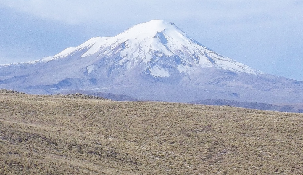
Ampato (possibly from Quechua hamp'atu[1] or from Aymara jamp'atu,[2] both meaning "frog") is a dormant 6,288-metre (20,630 ft) stratovolcano in the Andes of southern Peru. It lies about 70–75 kilometres (43–47 mi) northwest of Arequipa and is part of a north-south chain that includes the volcanoes Hualca Hualca and Sabancaya, the last of which has been historically active.
Key Information


Ampato consists of three volcanic cones, which lie on top of an older eroded volcanic edifice. They were formed sequentially by extrusion of lava flows, but Ampato has also had explosive eruptions which have deposited ash, lapilli and pumice in the surrounding landscape. One young lava flow has been dated to 17,000 ± 6,000 years before present, but a summit lava dome is even younger, and Holocene ash layers in surrounding peat bogs may testify to the occurrence of recent eruptions.
The present-day volcano is covered by an ice cap, and during the last glacial maximum glaciers advanced to low altitudes. In 1995, an Inca mummy known as Mummy Juanita was discovered on Ampato by Johan Reinhard; it had been offered as a human sacrifice more than six hundred years earlier on the mountain.
Geography and geomorphology
[edit]Ampato lies south of the Colca Canyon and at the southern end of a chain of volcanoes formed by Hualca Hualca and Sabancaya,[3] the last of which has been historically active.[4] Clockwise from northeast the towns of Colihuiri, Cajamarcana, Sallalli, Japo, Baylillas, Corinta and Collpa surround the volcano;[3] the city of Arequipa lies 70–75 kilometres (43–47 mi) to the southeast.[4]
Ampato is part of the Central Volcanic Zone of the Andes,[5] which in Peru manifests itself as several dozen Pleistocene volcanoes, some of which erupted in historical time including El Misti, Huaynaputina, Sabancaya and Ubinas. The largest historical eruption of the Andes took place at Huaynaputina.[6] Other volcanoes in the Peruvian Central Volcanic Zone are Sara Sara, Solimana, Coropuna, Andagua volcanic field-Huambo volcanic field, Chachani, Ticsani, Tutupaca, Yucamane, Purupuruni and Casiri.[7]

The volcano Ampato consists of three individual steep-sided cones which rise from a gentle glacially eroded foot. These three cones are lined up in southwest-northeast direction and the highest one reaches an elevation of 6,280 metres (20,600 ft)[4] or 6,288 metres (20,630 ft).[8] Ampato is one of the highest volcanoes in the Central Volcanic Zone[9] and the 35th highest summit in the Andes.[10] The volume of the edifice is about 38–42 cubic kilometres (9.1–10.1 cu mi), it covers an area of about 90–100 square kilometres (35–39 sq mi).[11]
The summit of the volcano is covered with an ice cap,[12] and the edifice is incised by cirques and glacial valleys.[11] The volcano is surrounded by three sets of moraines, the lowermost one at 4,250–4,450 metres (13,940–14,600 ft) elevation has been attributed to the last glacial maximum between 25,000-17,000 years ago, the middle one between 4,400–4,650 metres (14,440–15,260 ft) to a late readvance at the Pleistocene-Holocene epoch boundary and the higher ones above 4,800 metres (15,700 ft) to Holocene advances.[13]
Geology
[edit]Off the western coast of South America, the Nazca Plate subducts beneath the South America Plate[6] at a rate of 5–6 centimetres per year (2.0–2.4 in/year).[3] This subduction process is responsible for volcanism of the Central Volcanic Zone (CVZ)[6][9] in Peru, Bolivia and Chile.[7] The CVZ is one of the four volcanic belts in the Andean Volcanic Belt; the others are the Northern Volcanic Zone, the Southern Volcanic Zone and the Austral Volcanic Zone.[14] The subduction started during the Jurassic period after the opening of the southern Atlantic Ocean, which triggered the onset of subduction of the Nazca Plate.[9]
Volcanic arc-associated volcanism originally occurred within the Cordillera de la Costa in the Jurassic, but later it migrated resulting in the emplacement of the Tacaza and Toquepala groups and finally the Neogene Barroso group. The present-day volcanic arc is situated in the area of the Barroso group but has a narrower extent.[15] The pre-volcanic basement consists of 1.9-1.0-billion-year-old rocks of the "Arequipa Massif", which consists of gneiss and granulite. They are covered by the Yura Group of the Mesozoic and the Mesozoic-Paleogene Tiabaya unit; the former consists of marine sediments and the latter of volcanic sediments intruded by plutons. The Tacaza and Barroso groups are emplaced on the sediments.[16]
The basement beneath Ampato is formed by sedimentary and volcanic rocks of the Western Cordillera of Peru, and the rocks are of Mesozoic to Cenozoic age. A high plateau formed by ignimbrites and lavas of Pliocene to Miocene age rises above this basement. The terrain is cut by several different fault systems; one of these, the northeastward striking Sepina fault has been seismically active in the 20th and 21st centuries and seems to have controlled the development of the Ampato and Sabancaya volcanoes.[4]
Composition
[edit]Ampato has erupted different volcanic rocks at different stages, with the earliest ones generating andesite and dacite[17] and which define a potassium-rich suite.[18] The rocks contain amphibole, biotite, iron oxide, olivine, plagioclase, pyroxene and titanium oxide.[17]
The magmas derive from mantle melts, but undergo additional differentiation processes before reaching the surface.[19] Processes such as fractional crystallization, magma mixing and the absorption of crustal material by developing magmas have been invoked to explain the formation of the magmas of both Ampato and Sabancaya.[20] Estimating the rate of magma production at Ampato is difficult owing to the uncertainties in determining the volume of the edifice and the duration of repose times between eruptions; on average it appears to be 0.08–0.09 cubic kilometres per millennium (0.019–0.022 cu mi/ka). This rate does not consider "spurt"-like behaviour; volcano growth in fits and spurts has been observed at many other volcanic arc volcanoes.[21] The rate is about one order of magnitude less than at neighbouring Sabancaya volcano.[22]
Vegetation
[edit]The Western Cordillera features various climate zones, such as the quechua and suni zones. The vegetation that occurs at high altitudes is dominated by pioneer plants, with wetlands constituting additional centres of biodiversity.[23]
Eruptive history
[edit]Growth of Ampato and Sabancaya commenced no earlier than 800,000 years ago.[24] A 200–600-metre (660–1,970 ft) thick pile of andesitic lava flows with additional scoria and which crops out on the southern, southeastern and southwestern side of the Ampato volcano is the oldest volcanic stage of this volcano, with argon-argon dating yielding ages between 400,000 - 450,000 years before present.[25] Above this formation, another pile of dacitic lava flows constructed the first Ampato edifice, which was about the same size as the present-day volcano. This pile ("Moldepampa stage") is about 200–300 metres (660–980 ft) thick in outcrops and was emplaced between 230,000 - 200,000 years before present.[17]
After a pause in volcanic activity[26] and an intermediary stage ("Yanajaja stage"; one date obtained on this stage is 77,000 ± 4,000 years before present) that produced andesitic-dacitic lava flows which form a 200–300-metre (660–980 ft) thick unit on top of eroded remnants of the older Ampato volcanics,[17] the andesitic northern cone formed as the first of the three present-day cones. The southern cone developed in several different stages; a first stage generated lava flows emanating from the summit;[27] dating of two such flows has produced ages of 34,000 ± 8,000 and 40,000 ± 3,000 years before present. More than 20 metres (66 ft) of block-and-ash flows was erupted onto the eastern and western flanks of Ampato,[28] and these flows consist of one andesitic and one dacitic formation; both appear to relate to a lava dome forming stage of volcanic activity. These block-and-ash flows are themselves covered on both the eastern and the western flanks by more thick lava flows, which make up a 150–200 metres (490–660 ft) thick unit and again consist of one andesitic and one dacitic unit; both units appear to have been erupted during the last glacial maximum.[29]
Either during or before the last glacial maximum, Ampato erupted tephra during multiple explosive eruptions which today is preserved in two units, the Baylillas and the Corinta deposits. The first consists of lapilli, pumice and scoria and individual layers form thick sequences at large distances from the volcano, but are heavily eroded and thus difficult to measure in extent. Scoria flows identified on the southwestern-southern flanks of Ampato correspond to this unit. The dacitic Corinta deposits conversely were created during one large eruption[29] which also left a crater on Ampato;[30] it generated stratified 3–4-metre (9.8–13.1 ft) thick tephra deposits which contain pumice embedded within ash-rich layers,[29] and it is probably also the source of the pumice flow deposits on the south-southwestern flank. These contain dacitic pumice fragments in a matrix rich in ash and have thicknesses of more than 10 metres (33 ft) in the few outcrops; much of this unit was likely eroded away by glacial activity.[31]

The central cone grew in the gap between the northern and southern edifice and consists of lava flows again of andesitic to dacitic composition. These flows are together maximally 400–600 metres (1,300–2,000 ft) thick and one flow has been dated to 17,000 ± 6,000 years before present. A dacitic summit lava dome is not affected by glacial erosion and appears to be the youngest eruption product of Ampato.[30]
Early Holocene (11,000 - 8,000 years before present) ash layers in peat bogs around the volcano may have originated either on Ampato or on Sabancaya.[21] Late Holocene tephra layers dated to 1,790 ± 110, 2,050 ± 70 and 4,500 ± 125 likewise may have been erupted from Ampato, but Sabancaya is a more likely source for these ash layers.[32]
Hazards
[edit]Presently, Ampato is considered to be a dormant volcano.[33] Potential hazards from future eruptions at Ampato are lahars induced by melting of the icecap and sub-Plinian eruptions, considering the history of explosive eruptions at this volcano.[21]
The Peruvian geological service has published a hazard map that describes danger areas of both Ampato and Sabancaya. Hazards mapped include both the fall of ash and the formation of lahars which can advance to distances of 20 kilometres (12 mi) in the southerly valleys of Ampato. Pyroclastic fallout primarily threatens the vicinity of the volcano but large eruptions can result in fallout over large areas around the volcanic complex.[34]
Human history
[edit]The existence of Inka ceremonial platforms and ceremonial roads on Ampato has been reported.[35] Ampato was the site of human sacrifice during Inca times, around 1466 the Mummy Juanita was offered for sacrifice on the mountain, along with two other girls and a boy. The sacrifice took place on a platform on the summit of the volcano and was presumably intended to calm the mountain spirits during an eruption of the neighbouring volcano Sabancaya.[36] The mummies were discovered in 1995 by Johan Reinhard and colleagues on the summit of the mountain[37] and are presently in the Andean Sanctuaries Museum.[38]
Such sacrifices with children being the usual subjects are known as capacocha and the discoveries of their mummies on mountains in the Andes has gained them a lot of attention. The process served to tie the Inka empire more closely together, since children to be sacrificed were selected from the entire realm and the children adorned and their names remembered after the sacrifice.[39]
See also
[edit]References
[edit]- ^ Yachakuqkunapa Simi Qullqa - Qusqu Qullaw. Qhichwa Simipi (monolingual Quechua and bilingual Quechua-Spanish dictionary)
- ^ Radio San Gabriel, "Instituto Radiofonico de Promoción Aymara" (IRPA) 1993, Republicado por Instituto de las Lenguas y Literaturas Andinas-Amazónicas (ILLLA-A) 2011, Transcripción del Vocabulario de la Lengua Aymara, P. Ludovico Bertonio 1612 (Spanish-Aymara-Aymara-Spanish dictionary)
- ^ a b c Samaniego et al. 2016, p. 111.
- ^ a b c d Samaniego et al. 2016, p. 112.
- ^ Samaniego et al. 2016, p. 110,112.
- ^ a b c Samaniego et al. 2016, p. 110.
- ^ a b Rivera et al. 2023, p. 2.
- ^ Alcalá-Reygosa, Palacios & Zamorano Orozco 2016, p. 1161.
- ^ a b c Alcalá-Reygosa, Palacios & Zamorano Orozco 2016, p. 1160.
- ^ Gałaś, Panajew & Cuber 2015, p. 64.
- ^ a b Rivera et al. 2023, p. 5.
- ^ Juvigné et al. 2008, p. 160.
- ^ Samaniego et al. 2016, p. 113.
- ^ Rivera et al. 2023, p. 1.
- ^ Gałaś, Panajew & Cuber 2015, p. 63.
- ^ Rivera et al. 2023, p. 3.
- ^ a b c d Samaniego et al. 2016, p. 114.
- ^ Samaniego et al. 2016, p. 120.
- ^ Rivera et al. 2023, p. 14.
- ^ Samaniego et al. 2016, p. 121.
- ^ a b c Samaniego et al. 2016, p. 126.
- ^ Bablon, Mathilde; Quidelleur, Xavier; Samaniego, Pablo; Le Pennec, Jean-Luc; Lahitte, Pierre; Liorzou, Céline; Bustillos, Jorge Eduardo; Hidalgo, Silvana (15 May 2018). "Eruptive chronology of Tungurahua volcano (Ecuador) revisited based on new K-Ar ages and geomorphological reconstructions". Journal of Volcanology and Geothermal Research. 357: 396. Bibcode:2018JVGR..357..378B. doi:10.1016/j.jvolgeores.2018.05.007. ISSN 0377-0273.
- ^ Gałaś, Panajew & Cuber 2015, p. 66.
- ^ Rivera et al. 2023, p. 4.
- ^ Samaniego et al. 2016, p. 113,114.
- ^ Samaniego et al. 2016, p. 127.
- ^ Samaniego et al. 2016, p. 115.
- ^ Samaniego et al. 2016, p. 116.
- ^ a b c Samaniego et al. 2016, p. 117.
- ^ a b Samaniego et al. 2016, p. 118.
- ^ Samaniego et al. 2016, p. 117,118.
- ^ Juvigné et al. 2008, p. 171.
- ^ Alcalá-Reygosa, Palacios & Zamorano Orozco 2016, p. 1162.
- ^ "Mapa de peligros del volcán Sabancaya" (in Spanish). INGEMMET. Retrieved 26 January 2018.[permanent dead link]
- ^ Bello 2025, p. 7.
- ^ Chávez, Chávez; Antonio, José (2001). "Investigaciones arqueológicas de alta montaña en el sur del Perú". Chungará (Arica) (in Spanish). 33 (2): 283–288. doi:10.4067/S0717-73562001000200014. ISSN 0717-7356.
- ^ Andrushko et al. 2011, p. 324.
- ^ Bello 2025, p. 9.
- ^ Andrushko et al. 2011, p. 323.
Sources
[edit]- Alcalá-Reygosa, Jesús; Palacios, David; Zamorano Orozco, José Juan (16 February 2016). "Geomorphology of the Ampato volcanic complex (Southern Peru)". Journal of Maps. 12 (5): 1160–1169. Bibcode:2016JMaps..12.1160A. doi:10.1080/17445647.2016.1142479.
- Andrushko, Valerie A.; Buzon, Michele R.; Gibaja, Arminda M.; McEwan, Gordon F.; Simonetti, Antonio; Creaser, Robert A. (February 2011). "Investigating a child sacrifice event from the Inca heartland". Journal of Archaeological Science. 38 (2): 323–333. Bibcode:2011JArSc..38..323A. doi:10.1016/j.jas.2010.09.009. ISSN 0305-4403.
- Bello, Christian Vitry Di (28 October 2025). "Donde habitan los dioses: una aproximación a los apus más altos del Tawantinsuyu". Boletín de Arqueología PUCP (in Spanish) (37). doi:10.18800/boletindearqueologiapucp/202502.002. ISSN 2304-4292.
- Gałaś, Andrzej; Panajew, Paweł; Cuber, Piotr (30 November 2015). "Stratovolcanoes in the Western Cordillera – Polish Scientific Expedition to Peru 2003–2012 reconnaissance research". Geotourism/Geoturystyka. 37 (2): 61–68. doi:10.7494/geotour.2014.37.61. ISSN 2353-3641. Archived from the original on 27 January 2018. Retrieved 26 January 2018.
- Juvigné, Etienne; Thouret, Jean-Claude; Loutsch, Isabelle; Lamadon, Sébastien; Frechen, Manfred; Fontugne, Michel; Rivera, Marco; Dávila, Jasmine; Mariño, Jersy (1 June 2008). "Retombées volcaniques dans des tourbières et lacs autour du massif des Nevados Ampato et Sabancaya (Pérou méridional, Andes Centrales)". Quaternaire. 19 (2): 157–173. doi:10.4000/quaternaire.3362. hdl:20.500.12544/669.
- Rivera, Marco; Samaniego, Pablo; Nauret, François; Mariño, Jersy; Liorzou, Céline (November 2023). "Petrological and geochemical constraints on the magmatic evolution at the Ampato-Sabancaya compound volcano (Peru)". Lithos. 458–459 107364. Bibcode:2023Litho.45807364R. doi:10.1016/j.lithos.2023.107364.
- Samaniego, Pablo; Rivera, Marco; Mariño, Jersy; Guillou, Hervé; Liorzou, Céline; Zerathe, Swann; Delgado, Rosmery; Valderrama, Patricio; Scao, Vincent (September 2016). "The eruptive chronology of the Ampato–Sabancaya volcanic complex (Southern Peru)". Journal of Volcanology and Geothermal Research. 323: 110–128. Bibcode:2016JVGR..323..110S. doi:10.1016/j.jvolgeores.2016.04.038. ISSN 0377-0273.
Further reading
[edit]- Reinhard, Johan The Ice Maiden: Inca Mummies, Mountain Gods, and Sacred Sites in the Andes. 2005, Washington, D.C.: National Geographic Society.
- "Sabancaya". Global Volcanism Program. Smithsonian Institution.
- Biggar, John (2020). The Andes: A Guide for Climbers and Skiers (5th ed.). Andes Publishing (Scotland). p. 184 pp. ISBN 978-0-9536087-6-8.
- González-Ferrán, Oscar (1995). Volcanes de Chile. Santiago, Chile: Instituto Geográfico Militar. p. 640 pp. ISBN 978-956-202-054-1. (in Spanish; also includes volcanoes of Argentina, Bolivia, and Peru)
- De Silva, Shanaka L.; Francis, Peter (1991). Volcanoes of the Central Andes. Springer-Verlag. p. 216 pp. ISBN 978-3-540-53706-9.
External links
[edit]- Ampato on Summitpost
- Reygosa, Jesús Alcalá (2014). La evolución volcánica, glaciar y periglaciar del complejo Ampato (sur de Perú) (Thesis) (in Spanish). Universidad Complutense de Madrid.
- Reygosa, Jesús Alcalá (2007). La evolución de los glaciares en el complejo volcánico Ampato (Perú) (Thesis) (in Spanish). Universidad Complutense de Madrid.
| International | |
|---|---|
| National | |