
Atimonan
View on WikipediaThis article needs additional citations for verification. (November 2013) |
Atimonan, officially the Municipality of Atimonan (Tagalog: Bayan ng Atimonan), is a municipality in the province of Quezon, Philippines. According to the 2024 census, it has a population of 65,552 people.[5]
Key Information


.svg)
Etymology
[edit]There are three plausible origins of the name of the municipality:
- Atimon, an extinct tree alleged to have been prevalent in the area and had reportedly served many uses to the residents;
- The Tagalog phrase atin muna, signifying a policy, unity of feeling, and sentiments among the residents that bolster their spirit in the fight against their enemies during that time; and
- Simeona Mangaba, known to her townmates as Ate Monang, who was the older sister of the first town captain Francisco Mangaba and the founder of the town. This is the most popular version.[6]
History
[edit]Atimonan was founded by Simeona Mangaba on February 4, 1608, along the banks of the big Maling River, now known as Atimonan River.[7]
Living along the riverbank, the people have always been prey to Moro attacks and so for fear of Moro reprisals, the inhabitants decided to transfer to Palsabangon, now a barrio of Pagbilao, Quezon. However, the people felt discontented in Palsabangon because the place abounds in wild crocodiles that from time to time disturbed them. So, in 1610, after two years of stay, they left the place and transferred to Babyaw, a part of Atimonan. They settled in Babyaw for almost 14 years but transferred again to another site called Minanukan for some unknown reasons.
In 1635, they again transferred to another place called Bisita, but some families separated from the majority and settled in Yawe, now San Isidro in what is now Padre Burgos. The next year, when Simeona Mangaba learned of what happened to the original group of settlers, she, together with Fray Geronimo de Jesus, a Spanish friar, tried to unite them once more and convinced them to return to the place where it was first founded. The place is known now as Bagumbayan was during the time of Captain Pablo Garcia.
On January 1, 1917, barrio Laguimanoc was separated from Atimonan to become an independent municipality that is now known as Padre Burgos. On December 23, 1941, the occupying Japanese Imperial Army entered the towns through landing beaches in Atimonan.
Geography
[edit]Atimonan lies on the eastern shore of the province, 42 kilometers (26 mi) from Lucena and 172 kilometers (107 mi) southeast of Manila. Atimonan is bounded by the municipalities of Gumaca, Plaridel, Pagbilao and Padre Burgos.
Barangays
[edit]Atimonan is politically subdivided into 42 barangays, as indicated below. Each barangay consists of puroks and some have sitios.[8]
- Angeles
- Balubad
- Balugohin
- Barangay Zone 1 (Poblacion)
- Barangay Zone 2 (Poblacion)
- Barangay Zone 3 (Poblacion)
- Barangay Zone 4 (Poblacion)
- Buhangin
- Caridad Ibaba
- Caridad Ilaya
- Habingan
- Inaclagan
- Inalig
- Kilait
- Kulawit
- Lakip
- Lubi
- Lumutan
- Magsaysay
- Malinao Ibaba
- Malinao Ilaya
- Malusak
- Manggalayan Bundok
- Manggalayan Labak
- Matanag
- Montes Balaon
- Montes Kallagan
- Ponon
- Rizal
- San Andres Bundok
- San Andres Labak
- San Isidro
- San Jose Balatok
- San Rafael
- Santa Catalina
- Sapaan
- Sokol
- Tagbakin
- Talaba
- Tinandog
- Villa Ibaba
- Villa Ilaya
Climate
[edit]| Climate data for Atimonan, Quezon | |||||||||||||
|---|---|---|---|---|---|---|---|---|---|---|---|---|---|
| Month | Jan | Feb | Mar | Apr | May | Jun | Jul | Aug | Sep | Oct | Nov | Dec | Year |
| Mean daily maximum °C (°F) | 31.6 (88.9) |
32 (90) |
34 (93) |
34.6 (94.3) |
35.6 (96.1) |
36 (97) |
35 (95) |
35 (95) |
35.3 (95.5) |
35 (95) |
33 (91) |
32 (90) |
34.1 (93.4) |
| Mean daily minimum °C (°F) | 21 (70) |
20.3 (68.5) |
21.3 (70.3) |
21 (70) |
22.6 (72.7) |
23 (73) |
23 (73) |
23 (73) |
23 (73) |
23 (73) |
23.3 (73.9) |
23.3 (73.9) |
22.3 (72.0) |
| Average precipitation mm (inches) | 156.6 (6.17) |
169.3 (6.67) |
109 (4.3) |
60.9 (2.40) |
198.9 (7.83) |
235.4 (9.27) |
262.7 (10.34) |
156.2 (6.15) |
234.5 (9.23) |
326.8 (12.87) |
346.6 (13.65) |
304.3 (11.98) |
2,561.2 (100.86) |
| Average rainy days | 22 | 6 | 6 | 5 | 15 | 15 | 13 | 14 | 8 | 22 | 17 | 16 | 159 |
| Source: MDRRMO Atimonan[9] | |||||||||||||
Demographics
[edit]| Year | Pop. | ±% p.a. |
|---|---|---|
| 1903 | 11,203 | — |
| 1918 | 13,087 | +1.04% |
| 1939 | 18,512 | +1.67% |
| 1948 | 21,474 | +1.66% |
| 1960 | 32,294 | +3.46% |
| 1970 | 35,478 | +0.94% |
| 1975 | 37,483 | +1.11% |
| 1980 | 39,894 | +1.25% |
| 1990 | 46,651 | +1.58% |
| 1995 | 54,283 | +2.88% |
| 2000 | 56,716 | +0.94% |
| 2007 | 59,157 | +0.58% |
| 2010 | 61,587 | +1.48% |
| 2015 | 63,432 | +0.56% |
| 2020 | 64,260 | +0.27% |
| 2024 | 65,552 | +0.48% |
| Source: Philippine Statistics Authority[10][11][12][13][14] | ||
People from Atimonan are called Atimonanins. The primary language is Tagalog, with many local phrases and expressions. Manilans usually understand Atimonan Tagalog, albeit with some frustrations. Atimonanins are mostly Tagalogs, but some have a small percentage of Chinese and Spanish ancestry. Some Atimonanins can also speak Bicolano, Lan-nang, or Spanish.
Religion
[edit]The dominant religion in Atimonan is Roman Catholic. The culture in Atimonan is primarily ingrained in rural maritime Filipino settings. Other religions present are:
- The Church of Jesus Christ of Latter-day Saints (LDS) (commonly known as Mormon)
- Atimonan United Christian Ministries AUCM (Born-Again Christians)
- Iglesia Ni Cristo
- Seventh Day Adventist
- Jehovah's Witnesses
- Philippine Independent Church/ Iglesia Filipina Independiente (known as Aglipayans)
- Islam
- Members Church of God International commonly known as Ang Dating Daan
Our Lady of Angels Parish
[edit]Our Lady of Angels Parish is a member of Roman Catholic Diocese of Lucena.
- Parish Priest: Rev. Msgr. Emmanuel Ma. Villareal
- Parochial Vicar: Rev. Fr. Merlin Las Piñas
- Parochial Vicar: Rev. Fr. Ralph Peñaflorida
- Assisting Priest : Rev. Fr. Paul Liwanag
Parish of Our Lady of Angels (Philippine Independent Church)
- Parish Priest - Rev. Fr. Arnold Manalo Damayan, BTh, BAPA
Philippine Good News International
[edit]- Ptra. Analiza Satrain
Jesus Is Lord Church Atimonan Chapter
[edit]- Ptr. Ding Oraa
Economy
[edit]Poverty incidence of Atimonan
10
20
30
40
2000
31.78 2003
31.84 2006
16.60 2009
12.71 2012
37.34 2015
27.53 2018
6.10 2021
22.69 Source: Philippine Statistics Authority[15][16][17][18][19][20][21][22] |
The economy of Atimonan is sustained by fishing and agriculture. Many also engage in seafaring.
Tourism
[edit]The town is part of the Tourism Highway Program of the Department of Tourism.
- Quezon Protected Landscape
- ACEDRE Beach Resort
- Atimonan Feeder Port
- Pinagbanderahan Summit
- Bantakay Fall and Caves
- Atimonan Bay Park
- Atimonan Fish Port
- Atimonan Fish Sanctuary
- De Gracia Beach Floating Cottage
- Green Park Hotel and Resort
- Missy and Zane Hotel de Recepcion
- Villarreal Beach
- Rizza Beach Resort (D'Bay Resort)
- Playa De Lucia Hotel, Resorts and Restaurant
- Tinandog Heights
- Quezon National Park
- ZigZag Park
- Lumiliay Waterfalls
- Malusak Cave
- Cueva Santa
- Aloco Falls
- Robert's Kainan
- Taluo Falls (Coco)
Culture
[edit]Festivals
[edit]- Tagultol Fishing Festival
The Tagultol Festival is an evolution of various cultural activities, practised in previous years by Atimonanins. The Town and Patronal Fiesta every August 1 and 2, is simply celebrated with the usual parade, a cultural program, thanksgiving mass and procession. In 1981, during the administration of then Quezon Board Member and then Mayor of Atimonan Remedios V. Diestro, an activity was started – the Karakol. It is a fluvial parade held in the afternoon of the 2nd day of the fiesta. The boats travelled around Lamon Bay within the boundaries of the town proper headed by the Grand Boat, where the patron—Nuestra Señora de Los Angeles—was aboard. There were singing, dancing and band playing, all in expression of gratitude to the Almighty for the year's bountiful catch. The parade then joined the religious procession and ended at the church.
Later, it was done in the morning after the Thanksgiving mass at the Fishing Port and Boat Racing Competition, followed by the Karakol. The creation of the Lupong Tagapangasiwa ng Kultura at Sining sa Atimonan (LUPTAKSA) under the leadership of Mr. Francisco T. Laude, a retired public school teacher, put a new dimension and vigour to the town's cultural awareness and in the year 2003, the Tagultol Festival was finally launched. Tagultol, an old fishing method used by Atimonanins, was derived from the Tagalog word ugtol, meaning bounce. Tagultol fishing consists of a rectangular stone tied at the end of abaca strings dipped in honey.
Thorns of calamansi & similar plants with bait were tied 2 feet above the stone before dipping in water and moved in a bouncing movement. The festival is a five-day celebration starting on July 29 until August 2. The celebration is an array of both cultural and sports activities, talent and beauty contests participated by community organisations and individuals and headed by the local government's culture and arts council (LUPTAKSA) and Atimonan Tourism Council.
It can be held in Aliwan Fiesta 2018 during the festival is the Tagultol Fishing Festival, represented by: Atimonan Community Dancers.
The street dance is 15 members says: "The progressive town of Atimonan lies on the western shore of the province of Quezon, bound by flourishing gifts of nature and the abundance of Lamon Bay. The creation of the Tagultol Fishing Festival 15 years ago brought new vigour to Atimonan’s cultural awareness, as well as an expression of gratitude to the Almighty and the town’s patroness Nuestra Señora de los Angeles for the bountiful catch received by fisherfolk. The festival shows the old fishing method of “ugtol,” a Tagalog word meaning “bounce”. Tagultol fishing consists of a rectangular stone tied to a piece of abaca string dipped in honey to make it more resilient in salt water. The original music was composed by Francisco Laude, founder of Lupong Tagapangasiwa ng Kultura at Sining sa Atimonan. Please welcome the Atimonan Community Dancers’ portrayal of the Tagultol Fishing festival!"
- Pabitin Festival
The Town of Atimonan celebrates the Pabitin Festival every May 15 in honour of the patron saint of farmers, St. Isidore, almost the same in Lucban's Pahiyas Festival. During this festival, every house in the town proper has hanging decor such as vegetables, fruits, suman, dried fish wrapped in plastic and any other kinds of food, and when the statue of St. Isidore have passed the street, then the decoration will be thrown in the people who want to have the decorations.
Education
[edit]The Atimonan Schools District Office governs all educational institutions within the municipality. It oversees the management and operations of all private and public, from primary to secondary schools.[23]
Primary and elementary schools
[edit]- Atimonan United Methodist Christian School
- Atimonan Central Elementary School
- Atimonan Central School (Annex)
- Buhangin Elementary School
- Balubad Elementary School
- Caridad Ibaba Elementary School
- Casa dei Patino Montessori School
- Little Angels Montessori Learning Center
- Inalig Elementary School
- Magsaysay Elementary School
- Maligaya Elementary School
- Malinao Ibaba Elementary School
- Malinao Ilaya Elementary School
- Malusak Elementary School
- Our Lady of the Angels Academy
- Ponon Elementary School
- Rizal Elementary School
- San Rafael Elementary School
- Sapaan Elementary School
- Santa Catalina Elementary School (Annex)
- St. Louie Kids World Learning Center
- Tagbakin Elementary School
Secondary schools
[edit]- Atimonan National Comprehensive High School
- Balugohin Integrated National High School
- Maligaya National High School
- Malinao Ilaya Integrated National High School
- Malusak National High School
- San Rafael National High School
Higher educational institutions
[edit]- ACEBA Science & Technology Institute
- College of Science, Technology & Communication
- Leon Guinto Memorial College
- Our Lady of the Angels Academy
- Quezonian Educational College
Government
[edit]Local government
[edit]Municipal officials (2010–2013):
- Municipal Mayor: Jose F. Mendoza
- Municipal Vice Mayor: Joel M. Vergano
- Municipal Councilors:
- Zenaida D. Veranga
- Renato C. Sarmiento
- Cielyn S. Diestro
- Elmer M. Santander
- Maria Aurora A. Tamayo
- Nestor E. Santander
- John Francis L. Luzano
- Roseller A. Magtibay
- PPLB President: Ernesto S. Amandy
- PPSK President: Loid John L. Vergaño
Municipal officials (2013-2016):
- Municipal Mayor: Jose F. Mendoza
- Municipal Vice Mayor: Joel M. Vergaño
- Municipal Councilors:
- Zenaida D. Veranga
- Rizaldy L. Velasco
- Renato C. Sarmiento
- Elmer M. Santander
- Iñigo P. Mapaye
- Cielyn S. Diestro-Makayan
- Roseller A. Magtibay
- John Francis L. Luzano
- PPLB President: Ernesto S. Amandy
Municipal Officials (2016-2019)
- Municipal Mayor: Engr. Rustico Joven U. Mendoza
- Municipal Vice Mayor: Zenaida D. Veranga
- Municipal Councilors:
- Elmer M. Santander
- Rizaldy L. Velasco
- Nestor E. Santander
- Estela A. Lim
- Roseller A. Magtibay
- Maria Aurora A. Tamayo
- Nestor V. Laude
- Merlinda C. Pesigan
- PPLB President:Amado A. Vidal
- PPSK President: Dexter B. Alegre
Gallery
[edit]-
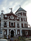 Our Lady of the Angels Parish
 -
 Mermaid statue of Atimonan
 -
 Port of Atimonan
 -
 Old Zigzag Road in Quezon National Park
 -
 Atimonan Zigzag Park


References
[edit]- ^ Municipality of Atimonan | (DILG)
- ^ "2015 Census of Population, Report No. 3 – Population, Land Area, and Population Density" (PDF). Philippine Statistics Authority. Quezon City, Philippines. August 2016. ISSN 0117-1453. Archived (PDF) from the original on May 25, 2021. Retrieved July 16, 2021.
- ^ "2024 Census of Population (POPCEN) Population Counts Declared Official by the President". Philippine Statistics Authority. July 17, 2025. Retrieved July 18, 2025.
- ^ "PSA Releases the 2021 City and Municipal Level Poverty Estimates". Philippine Statistics Authority. April 2, 2024. Retrieved April 28, 2024.
- ^ "2024 Census of Population (POPCEN) Population Counts Declared Official by the President". Philippine Statistics Authority. July 17, 2025. Retrieved July 18, 2025.
- ^ "History of Atimonan". Atimonan's Destination. CSG Communications. October 24, 2017. Retrieved April 24, 2025.
- ^ "History of Atimonan". Atimonan's Destination. CSG Communications. October 24, 2017. Retrieved April 24, 2025.
- ^ "Atimonan, Quezon Profile – PhilAtlas".
- ^ "Atimonan: Average Temperatures and Rainfall". MDRRMO Atimonan. Retrieved June 1, 2022.
- ^ "2024 Census of Population (POPCEN) Population Counts Declared Official by the President". Philippine Statistics Authority. July 17, 2025. Retrieved July 18, 2025.
- ^ Census of Population (2015). "Region IV-A (Calabarzon)". Total Population by Province, City, Municipality and Barangay. Philippine Statistics Authority. Retrieved June 20, 2016.
- ^ Census of Population and Housing (2010). "Region IV-A (Calabarzon)" (PDF). Total Population by Province, City, Municipality and Barangay. National Statistics Office. Retrieved June 29, 2016.
- ^ Censuses of Population (1903–2007). "Region IV-A (Calabarzon)". Table 1. Population Enumerated in Various Censuses by Province/Highly Urbanized City: 1903 to 2007. National Statistics Office.
- ^ "Province of". Municipality Population Data. Local Water Utilities Administration Research Division. Retrieved December 17, 2016.
- ^ "Poverty incidence (PI):". Philippine Statistics Authority. Retrieved December 28, 2020.
- ^ "Estimation of Local Poverty in the Philippines" (PDF). Philippine Statistics Authority. November 29, 2005.
- ^ "2003 City and Municipal Level Poverty Estimates" (PDF). Philippine Statistics Authority. March 23, 2009.
- ^ "City and Municipal Level Poverty Estimates; 2006 and 2009" (PDF). Philippine Statistics Authority. August 3, 2012.
- ^ "2012 Municipal and City Level Poverty Estimates" (PDF). Philippine Statistics Authority. May 31, 2016.
- ^ "Municipal and City Level Small Area Poverty Estimates; 2009, 2012 and 2015". Philippine Statistics Authority. July 10, 2019.
- ^ "PSA Releases the 2018 Municipal and City Level Poverty Estimates". Philippine Statistics Authority. December 15, 2021. Retrieved January 22, 2022.
- ^ "PSA Releases the 2021 City and Municipal Level Poverty Estimates". Philippine Statistics Authority. April 2, 2024. Retrieved April 28, 2024.
- ^ "Masterlist of Schools" (PDF). Department of Education. January 15, 2021. Retrieved October 10, 2025.
External links
[edit]- Atimonan Profile at PhilAtlas.com
- Official Website of Atimonan Municipal Government
- Philippine Standard Geographic Code
- Philippine Census Information
- Local Governance Performance Management System
Places adjacent to Atimonan | |
|---|---|
Lucena (capital and largest city) | |
| Municipalities |
|
| Component city | |
| Highly urbanized city |
|
Atimonan
View on GrokipediaEtymology and Founding
Name Origins
The name Atimonan is most commonly attributed to "Ate Monang," the affectionate nickname of Simeona Mangaba, a local figure reputed as the town's founder who established the settlement on February 4, 1608.[10][6] This derivation reflects oral traditions preserved in municipal lore, where her leadership in organizing early communities along the Quezon coastline led to the name's adoption, later formalized in local seals and records emphasizing her role.[5] Alternative explanations link the name to indigenous linguistic elements, such as the extinct Atimon tree, said to have been abundant in the region and utilized by early inhabitants for various purposes, though no botanical records confirm its prevalence or direct nomenclature influence. Another theory posits origins in the Tagalog phrase atin muna, interpreted as "ours first," potentially denoting a communal ethos of prioritizing local resources or unity among settlers, aligned with pre-colonial practices in coastal barangays.[11] These accounts, drawn from local histories rather than primary Spanish administrative surveys, lack corroboration from 17th-century colonial documents, which primarily recorded the name in its Hispanicized form without etymological detail.[12] During Spanish colonial administration, the name evolved through phonetic adaptation in official registries, appearing consistently as Atimonan in provincial mappings by the mid-17th century, reflecting standardization for governance without alteration to its core structure.[13] This persistence suggests the term's roots in pre-Hispanic Tagalog or local vernacular, predating formalized surveys that focused on territorial delineation over linguistic origins.Early Settlement
Local traditions hold that Atimonan originated as a settlement founded by Simeona Mangaba, referred to by locals as Ate Monang, on February 4, 1608, when she and several families established a community along the banks of the Maling River, later renamed the Atimonan River.[14] [10] This event marks the initial organized habitation under emerging Spanish colonial influence in the region, with Mangaba's brother, Francisco Mangaba, serving as the first local captain. The settlement's name derives from references to Mangaba's residence, as recounted in oral histories where Spanish inquiries elicited responses like "Ate ni Monang."[15] Early inhabitants likely included migrants from proximate areas in Tayabas (now Quezon) province, drawn by the river's resources for fishing and agriculture, forming the nucleus of what would become the town's core barangays.[5] Archival records confirm the 1608 date as the foundational benchmark, though primary documents detailing exact population or migrant origins remain limited, relying on municipal seals and local chronicles for attribution.[14] Pre-colonial evidence specific to Atimonan is absent from available records, but the site's coastal and riverine position aligns with regional patterns of indigenous fishing villages in Quezon, where archaeological finds elsewhere indicate habitation by seafaring communities centuries prior. These early groups subsisted on marine resources, setting the stage for the 1608 influx that formalized the community.History
Pre-Hispanic Period
The Atimonan area, situated along the eastern coast of southern Luzon, formed part of the pre-colonial Tagalog territory, where indigenous communities organized into autonomous barangays—kinship units typically comprising 20 to 100 families near coastal or riverine sites for access to marine resources and defense.[16] These settlements relied on datu-led hierarchies, with the datu serving as chief, arbiter, and military leader over freemen (timawa) and dependents (alipin), fostering social cohesion through customary law and reciprocal obligations rather than centralized states.[16] Economic activities centered on subsistence fishing, supplemented by swidden (kaingin) agriculture in upland clearings, where communities cultivated rice, taro, bananas, and other crops using slash-and-burn techniques adapted to the region's tropical forests and soils. Shell middens—accumulations of marine shells, fish bones, and tools—unearthed in Quezon Province sites attest to intensive coastal exploitation, with evidence of hooks, nets, and boats for nearshore gathering.[17] Regional trade linked these groups to other Luzon polities, as indicated by pottery shards and earthenware fragments recovered from Quezon archaeological contexts, suggesting exchange of goods like salt, dried fish, forest products, and metal tools via coastal routes. Burial jars and associated grave goods further reveal localized mortuary practices involving secondary burial and communal rituals, without evidence of large-scale hierarchies or monumental architecture.[18]Spanish Colonial Era
Franciscan friars arrived in Atimonan during the early 1600s, initiating Catholic conversions among the local population and laying the foundation for Spanish colonial administration. Their missionary efforts centered on establishing devotion to Nuestra Señora de los Ángeles, which became a focal point for community organization and spiritual governance.[19] In 1637, scattered settlements were consolidated into the formal pueblo of Atimonan, with Fray Juan Gaviria of the Order of Friars Minor (OFM) serving as its inaugural parish priest. A wooden church dedicated to Our Lady of the Angels was erected soon after, symbolizing the friars' dual role in religious conversion and civil oversight, as they often mediated between indigenous communities and Spanish authorities. This ecclesiastical structure facilitated the collection of tributes and the imposition of Spanish legal norms, integrating the area into the broader colonial framework of Tayabas province. By 1640, a more durable stone church had been constructed, one of the earliest such edifices east of Manila, underscoring the Franciscans' commitment to permanent settlement and defense against external threats like Moro raids. The local economy relied on agriculture within encomienda grants, producing rice and other staples for tribute payments that sustained colonial operations, while the coastal position enabled minor roles in provisioning galleon trade routes across the Pacific. Periodic resistance to tribute demands emerged in the 1700s, mirroring wider unrest against fiscal impositions, though specific records for Atimonan highlight friar influence in maintaining order.[20][21]American Occupation and World War II
The American colonial administration in the Philippines, following the Treaty of Paris in 1898, extended to Tayabas Province (now Quezon), incorporating Atimonan into a structured governance framework emphasizing secular education and infrastructure development. Public schools were rapidly established under the Department of Education founded in 1901, with English as the medium of instruction; in Atimonan, early implementation included summer teacher training sessions enrolling 60 students from May 24 to June 29 and 87 from May 4 to May 29 in the initial years post-occupation.[22] These efforts contributed to a nationwide literacy increase from approximately 20% at the onset of U.S. rule to nearly 40% by the late 1930s, driven by compulsory primary education and the deployment of over 500 American teachers initially.[23] Road networks were expanded to connect coastal towns like Atimonan, supporting economic integration and administrative control, as part of broader provincial improvements such as the Marikina-Infanta Highway initiated around 1910.[24] World War II disrupted these gains when Japanese forces invaded Luzon in December 1941 and occupied Atimonan by early 1942 as part of the broader conquest of the Philippines.[25] Local resistance emerged through guerrilla units, aligning with recognized groups like President Quezon's Own Guerrillas (PQOG) active in southern Luzon, which conducted sabotage and intelligence operations against Japanese garrisons despite harsh reprisals including forced labor and executions.[26] These fighters, often drawing from pre-war civilian militias, harassed supply lines and maintained Allied contacts amid widespread famine and disease under occupation.[27] Liberation efforts intensified in 1945 during the U.S. Sixth Army's Luzon campaign, with combined American and Philippine Commonwealth forces advancing southward to clear Japanese holdouts in eastern Tayabas. Atimonan was secured by the main assault force in the central sector, alongside nearby areas like Siniloan, as part of operations dismantling enemy defenses along the Pacific coast from January through August. Guerrilla auxiliaries, including elements of Marking's Free Philippine Guerrillas and PQOG, supported the push, suffering heavy losses in coordinated actions against entrenched Japanese troops.[1] U.S. military logs record the town's recapture as a key step in isolating remaining pockets, though specific local casualty figures remain tied to broader provincial engagements exceeding hundreds among Filipino irregulars.[28]Post-Independence Developments
Following Philippine independence on July 4, 1946, Atimonan integrated into the province of Quezon, which was renamed from Tayabas by Republic Act No. 14 signed on September 7, 1946, in honor of former President Manuel L. Quezon.[29] This administrative continuity supported local governance stability amid national post-war reconstruction efforts, with Atimonan maintaining its status as a coastal municipality focused on agriculture and fishing. Early rural development initiatives, including community-based agricultural extension services introduced in the late 1940s and 1950s under the Philippine government's post-war rehabilitation programs, aided recovery from wartime disruptions by promoting crop diversification and basic irrigation in Quezon's rural areas.[30] Census data reflect steady population expansion as a key indicator of economic stabilization and rural productivity gains. The municipality's population rose from 21,474 in the 1948 census to 32,294 by 1960, a growth rate of approximately 3.65% annually, driven by natural increase and returning residents post-World War II.[4] By 1970, it reached 35,478, and 37,483 in 1975, with annual growth slowing to around 1% amid broader national trends of rural-to-urban migration seeking industrial jobs in Manila and limited local mechanization.[4] These patterns highlight agriculture—primarily rice, coconut, and fisheries—as core growth drivers, bolstered by national land reform efforts that distributed parcels to tenant farmers, though implementation in Quezon faced challenges from uneven tenancy structures.[30] During the Marcos era (1965–1986), including the period of martial law from 1972, Atimonan benefited from national infrastructure pushes emphasizing rural connectivity, such as expanded road networks linking coastal towns to inland markets and ports, which facilitated agricultural exports despite macroeconomic strains from debt accumulation.[31] These projects, part of broader schemes to modernize rural economies, improved transport for local produce but coincided with socioeconomic pressures in Quezon, including insurgency-related setbacks that hampered sustained investment. Population growth moderated into the 1980s, underscoring reliance on subsistence farming and seasonal fishing amid out-migration, which reduced labor pools but introduced remittances as a supplementary economic factor.[4]Geography
Location and Administrative Divisions
Atimonan is situated in the eastern part of Quezon Province, within the Calabarzon region (Region IV-A) of Luzon, Philippines, approximately 173 kilometers southeast of Manila. Its central geographic coordinates are approximately 14°00′N 121°55′E.[4] The municipality borders the Pacific Ocean along its eastern coastline, providing access to maritime resources, while its western boundaries are defined by the rugged terrain of the Sierra Madre mountain range. To the north, it adjoins Plaridel and Gumaca, and to the south, it neighbors Alabat and Perez, with additional proximity to inland municipalities such as Agdangan and Unisan.[4] The total land area of Atimonan measures 239.66 square kilometers, positioning it as the 21st largest municipality in Quezon Province by area.[4] This extent encompasses coastal plains, rolling hills, and forested uplands, as delineated by official surveys from the Philippine Statistics Authority and related mapping authorities. Administratively, Atimonan is classified as a first-class municipality based on its average annual income exceeding 50 million Philippine pesos, reflecting its economic scale and infrastructure development.[2] Atimonan is subdivided into 42 barangays, the smallest administrative units in the Philippines, which facilitate local governance and community services across its territory.[4] This division supports decentralized administration, with each barangay handling matters pertinent to its residents while aligning under the municipal government's oversight.Barangays
Atimonan is politically subdivided into 42 barangays, consisting of four urban zones in the poblacion and 38 rural barangays.[4] The 2020 Census of Population and Housing reported a total population of 64,260 across these divisions, with the majority residing in rural areas focused on agriculture and fishing, while the urban zones function as residential and commercial hubs.[4] The barangays are:- Angeles (rural agricultural community)
- Balubad (rural, inland farming)
- Balugohin (rural agricultural)
- Barangay Zone 1 (urban poblacion, commercial center)
- Barangay Zone 2 (urban poblacion, residential)
- Barangay Zone 3 (urban poblacion, administrative hub)
- Barangay Zone 4 (urban poblacion, mixed residential-commercial)
- Buhangin (rural, agriculture)
- Caridad Ibaba (coastal fishing and farming)
- Caridad Ilaya (rural farming)
- Habingan (rural agricultural)
- Inaclagan (rural, inland agriculture)
- Inalig (rural farming)
- Kilait (rural agricultural)
- Kulawit (rural, agriculture)
- Lakip (rural farming)
- Lubi (rural agricultural)
- Lumutan (rural, forestry-adjacent agriculture)
- Magsaysay (rural farming)
- Malinao Ibaba (coastal fishing hub)
- Malinao Ilaya (rural agriculture)
- Malusak (rural farming)
- Manggalayan Bundok (upland rural, agriculture)
- Manggalayan Labak (rural agricultural)
- Matanag (rural farming)
- Montes Balaon (upland rural agriculture)
- Montes Kallagan (rural, agriculture)
- Ponon (rural farming)
- Rizal (rural agricultural)
- San Andres Bundok (upland rural)
- San Andres Labak (rural agriculture)
- San Isidro (rural farming)
- San Jose Balatok (rural, small-scale agriculture; population 70 in 2020)
- San Rafael (rural agricultural)
- Santa Catalina (rural farming; population 2,723 in 2020)
- Sapaan (coastal, fishing support)
- Sokol (rural agriculture)
- Tagbakin (rural agricultural; largest barangay with 6,317 residents in 2020)
- Talaba (coastal fishing community)
- Tinandog (rural farming)
- Villa Ibaba (coastal-adjacent, mixed fishing-agriculture)
- Villa Ilaya (rural agriculture)