Hubbry Logo
BabeldaobBabeldaobMain
Open search
Babeldaob
Community hub
Babeldaob
logo
8 pages, 0 posts
0 subscribers
Be the first to start a discussion here.
Babeldaob
Babeldaob
from Wikipedia

Babeldaob (also Babelthuap) is the largest island in the island nation of Palau. It is in the western Caroline Islands, and the second largest island (after Guam) in the Micronesia region of Oceania. Palau's capital, Ngerulmud, is located on Babeldaob, in Melekeok State.

Key Information

Babeldaob is one of the most underdeveloped populated islands in the Pacific Ocean. The area of Babeldaob, 331 km2 (128 sq mi), makes up over 70% of the land area of the entire Republic of Palau. It has about 30% of the country's population, with about 6,000 people living on it.

Geography

[edit]

Babeldaob is located northeast of Koror Island, and its northern portion contains the site of the new national capital, Ngerulmud. The southern end of the island is in Airai, Palau's second-most populous state. The Airai Airport on the island is the nation's principal airport.

The Koror-Babeldaob Bridge links Babeldaob Island at Airai to Koror Island.

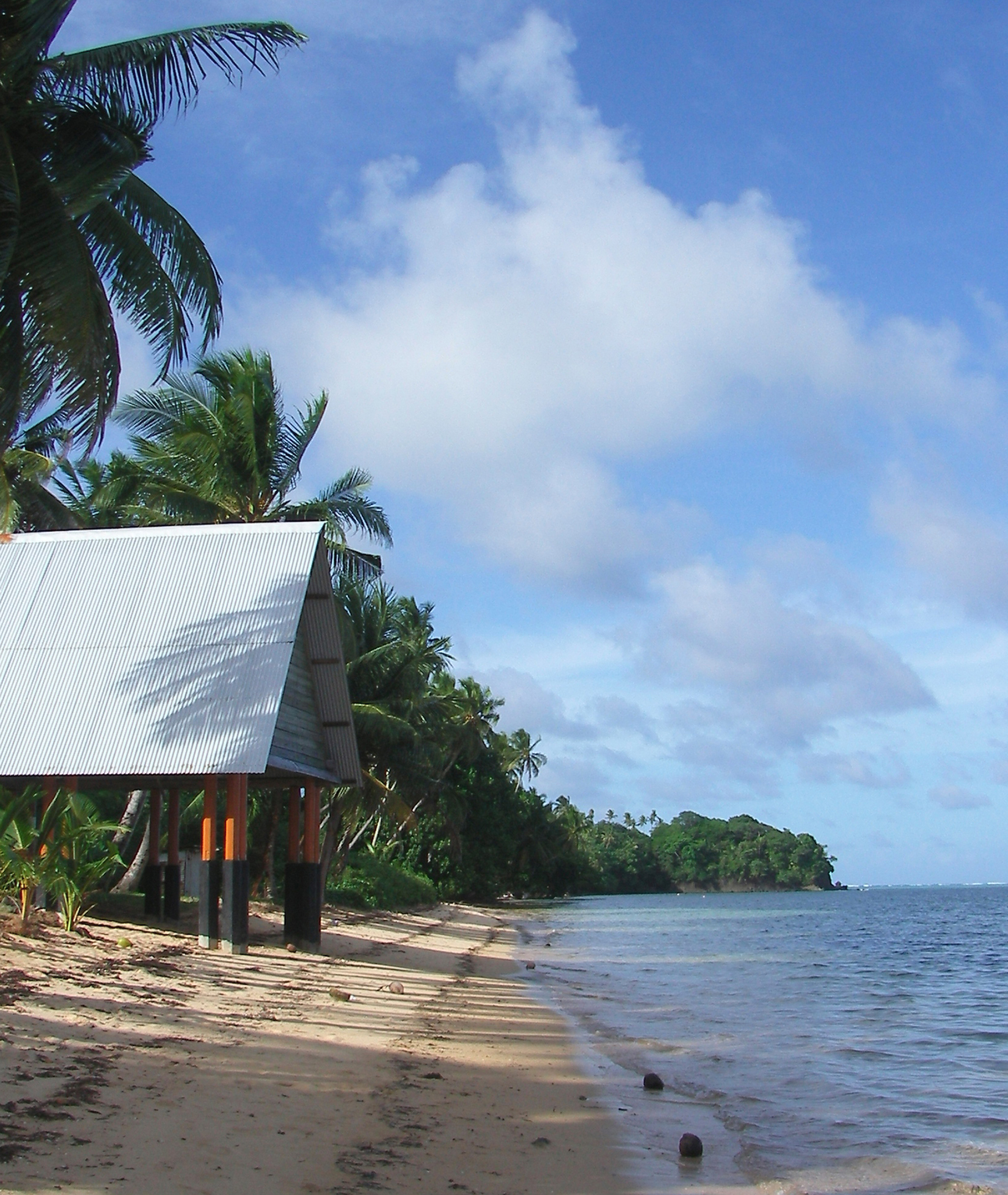
Unlike most of the islands of Palau, Babeldaob is mountainous. It contains Palau's highest point, the 242 m (794 ft)-tall Mount Ngerchelchuus. Babeldaob's eastern coast has many sandy beaches, in particular north from Melekeok to Ngaraard, and the island's western coast has a shoreline with many mangrove forests.[1]

Of the 16 states of Palau, Babeldaob encompasses 10, which are:

The Palau fruit dove is endemic to Palau and is the country’s national bird

Environment

[edit]

Important Bird Areas

[edit]

The central forested Middle Ridge of Babeldaob encompasses the headwaters of most of the island’s watersheds. Some 13,767 ha in area, it has been designated an Important Bird Area (IBA) by BirdLife International because it supports populations of most of Palau’s endemic birds, including Micronesian megapodes, Palau ground doves, Micronesian imperial pigeons, Palau fruit doves, swiftlets, owls and kingfishers, Micronesian myzomelas, morningbirds, Palau fantails, flycatchers and bush warblers, dusky and citrine white-eyes, and Micronesian starlings.[2] The Western Ridge IBA adjoins Middle Ridge in the north-west of the island. This 2,608 ha site contains populations of the same bird species,[3] as does the 1,135 ha Ngerutechei IBA on the western side of the island, which also includes riverine mangrove habitat.[4]

History

[edit]

First sighting of Babeldaob, Koror and Peleliu recorded by Europeans was by the Spanish expedition of Ruy López de Villalobos at the end of January 1543. They were then charted as Los Arrecifes ("The Reefs" in Spanish).[5] In November and December 1710 these three islands were again visited and explored by the Spanish missionary expedition commanded by Sargento Mayor Francisco Padilla on board of the patache Santísima Trinidad. Two years later they were explored in detail by the expedition of Spanish naval officer Bernardo de Egoy.[6] It was in the Spanish East Indies from 1686 to 1899.

As a consequence of the Spanish–American War, Spain sold Palau (including Babeldaob), the Carolines and the Northern Marianas (except Guam) to the German Empire for 17 million goldmark pursuant to the German–Spanish Treaty (1899). The newly acquired islands were administered from German New Guinea. Babeldaob was the destination to which the 426 members of the Sokehs tribe were banished by colonial authorities following the Sokehs Rebellion on Sokehs Island and Pohnpei.

In the early months of World War I, the Empire of Japan occupied all German islands north of the equator. As a League of Nations mandatory power after the war, Japan returned the Sokehs to Pohnpei in stages between 1917 and 1927.[7]

During World War II a Japanese garrison on Babeldaob was composed of 21,449 Imperial Japanese Army men under the command of Lieutenant-General Sadae Inoue and 8,286 Imperial Japanese Navy men under the command of Vice-Admiral Kenmi Itoh.[8] Allied forces bypassed Babeldaob during the war.[8]

See also

[edit]

Notes

[edit]

References

[edit]
Revisions and contributorsEdit on WikipediaRead on Wikipedia
from Grokipedia
Babeldaob, also spelled Babelthuap, is the largest island in the and the second-largest in after , covering 153 square miles (approximately 396 square kilometers) and accounting for about 80 percent of 's total land area of 189 square miles. Located in the western of the western , roughly 550 miles east of the , the island is volcanic in origin and features rugged, mountainous terrain rising to a high point of 242 meters (794 feet) at Mount Ngerchelchuus. It is renowned for its diverse ecosystems, including undulating forests, grasslands, rivers, waterfalls, wetlands, mangroves, and beaches, as well as Lake Ngardok, the largest natural freshwater lake in at about 22.7 acres. Measuring approximately 37 kilometers (23 miles) in length from north to south and 6 to 13 kilometers (4 to 8 miles) in width, Babeldaob is divided into ten of Palau's sixteen states: Airai, Aimeliik, Ngeremlengui, Ngerchelong, Ngchesar, , Ngiwal, Ngaraard, Ngardmau, and Ngatpang. The island's population was approximately 6,000 according to the 2020 census, representing about 34 percent of Palau's total residents of 17,614, with most communities concentrated along the coasts and speaking Palauan, the ; the predominant religion is Roman Catholicism. It serves as a vital cultural and political hub, hosting the national capital of in State since 2006 and in Airai State, which features a 2,200-meter (7,200-foot) . The island is connected to the former capital of via the Japan-Palau Friendship Bridge, part of the circumferential Compact Road built during Japanese colonial rule. Human settlement on Babeldaob dates back over 3,000 years to Austronesian migrants from and , who developed a complex matrilineal society with terraced hill fields and monumental earthworks for agriculture and defense. The island experienced successive colonial administrations, beginning with Spanish control from 1521 to 1899, followed by German rule until 1914, Japanese occupation from 1914 to 1944—which included infrastructure development like roads, schools, and resource —and U.S. administration from 1947 until 's in 1994. Today, Babeldaob's economy revolves around , , and , with ongoing conservation efforts to protect its , including the around the lake, which supports endemic species and serves as a primary freshwater source.

Geography and Geology

Physical Features

Babeldaob, the largest island in the Republic of Palau, spans an area of 396 km² (153 sq mi), accounting for about 80% of the nation's total land area of 489 km² (189 sq mi). This substantial size underscores its dominance in Palau's , featuring a varied that includes undulating forests, grasslands, and wetlands. The island's terrain is predominantly mountainous, rising to its highest point at Mount Ngerchelchuus, which reaches an elevation of 242 m. Geologically, Babeldaob originated from volcanic activity during the Eocene epoch, with formations including the Babeldaob volcanics, overlain by limestone resulting from uplift and erosion. Along its coasts, Babeldaob exhibits diverse features, including sandy beaches primarily on the eastern side, extensive swamps on the western shoreline, and fringing reefs that extend notably along the eastern edge. The island's internal road network, highlighted by the 85-km Compact Road that encircles it, represents the longest such system in , facilitating access across its rugged interior.

Climate and Hydrology

Babeldaob features a tropical rainforest climate characterized by consistently warm temperatures averaging 27–30°C throughout the year, with minimal seasonal variation due to its equatorial location. Humidity remains high at around 80–85%, contributing to the lush vegetation across the island. The island experiences a distinct wet season from May to November, during which heavy rainfall predominates, averaging up to 3,000 mm annually and peaking in July and August with frequent downpours that can exceed 400 mm in a single month. In contrast, the dry season spans December to April, with reduced precipitation averaging 100–200 mm per month, though occasional showers still occur, and trade winds provide some relief from the heat. This bimodal pattern supports the island's hydrological cycle but also exposes it to vulnerabilities such as typhoons, which are more frequent during the wet season and can bring destructive winds and storm surges. Climate change exacerbates these risks, with rising sea levels projected to increase by approximately 25 cm by 2050, leading to heightened and on Babeldaob's shorelines. These changes, combined with more intense typhoons, threaten and ecosystems, while altered rainfall patterns could intensify both flooding and dry spells. Babeldaob's hydrology is dominated by its network of rivers and streams, with the Ngerikiil River in Airai State serving as the primary surface water source, supplying about 4 million gallons daily to treatment facilities for much of Palau's population. The island also features Lake Ngardok, the largest natural freshwater lake in , covering approximately 9.2 hectares (22.7 acres) and serving as an important ecological and water resource. The island also relies on from freshwater lenses beneath its volcanic soils, which store rainwater recharge but are susceptible to over-extraction and contamination. Complementing these, widespread rainwater collection systems—used by over 95% of households—provide supplemental , often stored in rooftop cisterns to buffer against seasonal shortages. The 2023–2024 El Niño event significantly impacted the island, causing abnormal dryness from late 2023 into early 2024 that reduced reservoir levels and strained water supplies, with rainfall deficits up to 50% below average in key months. These variable conditions influence local by stressing and forest habitats through altered moisture levels.

Demographics and Administration

Population and Settlements

Babeldaob is home to approximately 5,500 residents as of the 2020 census, accounting for about 31% of 's total of 17,614. With an annual growth rate of 0.39%, the island's is estimated at around 5,600 for 2025. The ethnic makeup consists primarily of Palauans, who are Micronesian with Malayan and Melanesian admixtures (70.6%), alongside Asians (26.5%), Carolinians (1.2%), and other groups (1.7%). Key settlements include , the national capital since 2006 located in State (state population 318 as of 2020), Melekeok itself, and Airai (population 2,529), which features a mix of rural villages and more developed areas near the island's compact road system. Palau's overall rate stands at 0.39% annually, influenced by from densely populated areas like Koror State (11,199 residents) to Babeldaob, particularly following the capital's relocation. Housing on the island blends traditional thatched-roof structures with modern homes, though development faces constraints from land scarcity, as only 14% of 's total area is suitable for building or .

Government and Administrative Divisions

Babeldaob serves as the administrative heart of , hosting ten of the nation's sixteen states: Aimeliik, Airai, , Ngaraard, Ngarchelong, Ngardmau, Ngatpang, Ngchesar, Ngeremlengui, and Ngiwal. These states function as semi-autonomous municipalities with their own constitutions, local legislatures, and governors elected every four years, allowing for tailored governance on issues such as , education, and community services. At the state level, traditional leadership integrates with modern democratic structures, where high-ranking chiefs—known collectively as the klobak—advise elected officials on customary practices and , ensuring cultural continuity alongside elected decision-making. The island's political significance is underscored by its role as the location of Palau's national capital, , established in 2006 within State to redistribute development away from the overconcentrated urban center of . This relocation, a deliberate policy choice outlined in Palau's 1981 Constitution, aimed to promote balanced growth across the by constructing a new government complex on Babeldaob, including the Olbiil Era Kelulau—the bicameral National Congress comprising a nine-member and a 16-member House of Delegates—and executive offices for the president and cabinet. The move represented a pivotal political event, involving national debates on investment and regional equity, ultimately centralizing federal institutions while preserving state-level autonomy. Complementing this hybrid system, the Council of Chiefs provides national advisory input, drawing one traditional leader from each of Palau's 16 states to counsel the president on matters intersecting and constitutional . On Babeldaob, titles such as the Reklai of exemplify this blend, where chiefs like the ibedul in certain states collaborate with governors to mediate local disputes and uphold in policy implementation. This framework fosters a model that balances democratic elections with indigenous , particularly vital on an island encompassing over half of Palau's states and serving as the seat of federal power.

History

Prehistory and Early Settlement

The earliest human settlement of Babeldaob, the largest island in the archipelago, occurred approximately 3,300 to 4,500 years ago, with evidence indicating colonization by Austronesian-speaking peoples originating from Island , possibly including regions of modern-day , the , or . Archaeological data from cores and suggest initial human activity as early as 4,437 calibrated years (cal ), marked by the introduction of crops like (Colocasia esculenta) and swamp taro (Cyrtosperma chamissonis), alongside landscape modifications such as expansion around 3,100 cal . These migrants likely arrived via voyaging canoes, establishing coastal and inland sites on Babeldaob before tectonic uplift around 4,200 cal shifted settlement patterns inland. Archaeological investigations reveal a rich prehistoric landscape on Babeldaob, including ancient village sites, terraced earthworks, and . The Compact Road Project (1996–2005) uncovered over 30 sites with radiocarbon dates spanning 3,000 cal BP, featuring stone platforms, house foundations, and taro pondfields, such as the Ngimis site (dated 3,343–3,080 cal BP). Terraced hill fields, particularly in Airai State, consist of earthen platforms and ridges constructed starting around 2,250 cal BP, peaking between 1,950 and 1,500 cal BP, and used for , habitation, and possibly purposes; these "green pyramids" cover extensive upland areas and ceased use by 750 cal BP. , including over 150 reddish paintings of handprints, geometric motifs, boats, and human figures, adorns coastal cliffs in the Rock Islands near Babeldaob and inland engravings on the island itself, dating to about 3,400 years ago and tied to the broader Austronesian painting tradition. Over time, Babeldaob's societies developed matrilineal systems, where , lineage, and traced through female lines, organizing communities into exogamous kin groups, households, villages, and regions led by hereditary chiefs (rubak). Subsistence economies centered on cultivation in terraced fields and wetland pondfields, supplemented by marine fishing targeting reef species like and wrasses, , and , as evidenced by isotopic analysis (δ¹³C: -15.9‰ to -16.7‰; δ¹⁵N: 11.0‰) from burials at nearby sites like Chelechol ra Orrak (3,000–1,700 cal BP). Oral traditions preserved these origins through legends of creation and ancestral spirits; for instance, the Latmikaik birthed half-fish, half-human progenitors, while the goddess Milad, surviving a great , bore four children who founded key districts like Airai and , linking terraces to divine ladders between worlds and ancestral spirits (bladek) as guardians of . These narratives, tied to earthworks and monoliths, underscore a worldview where spirits of high-ranking ancestors mediated between the living, gods (chelid), and the land. The first recorded European contact with Babeldaob occurred in 1543, when Spanish explorer sighted the islands and claimed them for during his voyage across the western Pacific. However, the surrounding reefs prevented landing, resulting in minimal immediate impact on indigenous societies, which continued their isolated development for over two centuries.

Colonial and Wartime Periods

Babeldaob, as the largest island in the archipelago, experienced significant transformations during the colonial era beginning with Spanish control in the late 19th century. asserted sovereignty over in 1885, integrating it into the and administering it from the , though direct governance remained limited. Spanish missionaries sought to introduce , establishing a lasting religious influence despite initial resistance from indigenous communities, while efforts to curb inter-village warfare marked early administrative interventions. Economic activities focused on emerging copra trade, with coconut plantations introduced as a to support colonial exports, laying groundwork for later exploitation. This period ended in 1899 when , following its defeat in the , sold to for 4 million pesos. German administration from 1899 to 1914 emphasized resource extraction and infrastructure development across the islands, including Babeldaob. As part of the protectorate, officials established a resident government in and promoted copra production as the primary export, utilizing native labor for work. began on nearby in 1909, with operations extending influences to Babeldaob through labor recruitment and transport networks, though the island itself saw more focus on . Infrastructure improvements included the of roads, administrative buildings, and schools, aimed at enhancing colonial efficiency and native welfare through education and health initiatives. These developments altered local landscapes and social structures, with Germans conducting surveys to map resources and suppress traditional practices deemed incompatible with colonial order. Control shifted in 1914 when seized at the outset of . Under the Japanese from 1914 to 1944, Babeldaob underwent rapid modernization and demographic changes, with serving as the administrative hub. Japan formalized control through a in 1920, encouraging civilian migration that swelled the non-indigenous population; by , Japanese residents outnumbered Palauans in urban areas, reaching over 30,000 during wartime preparations. Agricultural intensification included plantations and farms on Babeldaob and surrounding islands, alongside expanded and mining, which transformed forested areas into export-oriented landscapes. Formal education systems were introduced, blending instruction with vocational training to integrate locals into the colonial , while like roads and ports facilitated resource shipment. Military buildup accelerated in the late , with Babeldaob hosting key installations as Japanese forces fortified the islands against anticipated Allied advances. During , Babeldaob functioned as the Japanese headquarters for , hosting command centers in amid escalating Pacific theater conflicts. The U.S. launched Operation Stalemate II in September 1944, invading and while bypassing Babeldaob due to its dense terrain and fortified defenses, which included approximately 29,000 troops. Intense naval and air bombardments targeted southern Babeldaob and nearby , destroying infrastructure and causing civilian hardships, though ground fighting remained minimal on the island itself. By November 1944, U.S. forces secured the southern islands, isolating Japanese remnants on Babeldaob, where starvation and guerrilla resistance persisted until formal surrender in 1945. Following the war, Babeldaob fell under U.S. administration as part of the Trust Territory of the Pacific Islands from 1947 to 1978, with the U.S. Navy governing initially before transitioning to civilian oversight. Reconstruction focused on stabilizing the economy through copra resumption and basic repairs, while the Trust Territory status integrated into broader U.S. Pacific policies. Nearby nuclear testing in the , part of the same trusteeship, established exclusion zones around and Enewetak Atolls, influencing regional security and environmental concerns that indirectly affected Palauan waters and migration patterns. This era set the stage for negotiations, culminating in Palau's path toward independence.

Post-Independence Developments

Following the establishment of the Trust Territory of the Pacific Islands in 1947, Palau transitioned toward self-governance, with the United States administering the territory until Palau's independence in 1994. Palau held multiple referendums on its political status throughout the 1980s and early 1990s, culminating in the approval of the Compact of Free Association (COFA) in a November 1993 vote, which addressed constitutional concerns over nuclear issues through amendments. This paved the way for Palau's independence on October 1, 1994, marking the end of U.S. administration and the establishment of the Republic of Palau under the COFA, which grants the U.S. defense responsibilities in exchange for economic assistance and other benefits. In 2006, relocated its capital from to in State on Babeldaob, fulfilling a constitutional mandate from 1979 to establish a new within a of to promote balanced national development and alleviate overcrowding in . This move centralized administrative functions on Babeldaob, 's largest island, fostering regional growth. A key infrastructural milestone was the completion of the Compact Road in October 2007, a 53-mile U.S.-funded highway encircling Babeldaob at a cost of $149 million, which enhanced connectivity to the new capital, , and the island's 10 states, boosting economic access and development. The 2010s saw significant political developments, including the 2010 U.S.-Palau Compact Review Agreement, which extended economic aid for 15 years and addressed ongoing constitutional interpretations of rights and governance amid judicial challenges to executive powers and civil liberties. In the 2024 general election on November 5, incumbent President Surangel Whipps Jr. secured re-election, reinforcing Palau's commitment to the COFA and its federal structure, where the 16 states, including those on Babeldaob, maintain substantial autonomy in local affairs through elected delegates to the National Congress. Contemporary challenges for Babeldaob and include heavy reliance on U.S. aid under the COFA, with $80.4 million allocated for 2025 to support , , and , amid a renewed 20-year agreement providing $890 million starting in 2024; this dependency sustains approximately 40 percent of the national budget but exposes the islands to fluctuations in U.S. foreign assistance. In 2025, discussions on climate adaptation funding intensified, highlighted by the Second Pacific Disaster Risk Management Ministers Meeting in in November, where leaders addressed climate-induced displacement and called for scaled-up ; 's Enhanced for 2025-2030 outlines $450 million in adaptation needs across sectors like , , and coastal on vulnerable islands like Babeldaob, seeking support from funds such as the .

Environment and Ecology

Biodiversity and Habitats

Babeldaob, the largest island in , supports a rich array of endemic flora and fauna as part of the Palau tropical moist forests , which is recognized for its high . The island's interior is dominated by montane rainforests covering approximately 75% of its land area, characterized by tall trees such as and diverse understory plants adapted to the humid, tropical conditions. These forests harbor unique plant species, including the endemic palm Ponapea palauensis, a rare clustering palm restricted to 's and found in scattered patches on Babeldaob's forested ridges. The island's avian diversity is notable, with recent surveys documenting over 100 species, including several endemics restricted to . Key examples include the Palau fruit-dove (Ptilinopus pelewensis), a vibrant green-and-red pigeon that inhabits the canopy and feeds on native fruits, and the Micronesian (Todiramphus cinnamominus palauensis), a endemic to known for its striking blue plumage and preference for forested streams on Babeldaob. These birds contribute to the island's role as a key area, with the Western Ridge of Babeldaob supporting nearly all of 's restricted-range species except the giant white-eye. In addition to rainforests, Babeldaob features grasslands resulting from World War II-era , which now cover about 18% of the landscape and provide for grassland-adapted species like certain sedges and birds. Wetland mangroves fringe much of the island's coastline, forming dense stands of and Bruguiera species that serve as critical nurseries for juvenile fish and support in intertidal zones. These mangrove ecosystems enhance the island's ecological connectivity by filtering nutrients and stabilizing shorelines. Babeldaob's hydrology includes Lake Ngardok, the largest natural freshwater lake in , covering about 22.7 acres and surrounded by the . The lake supports endemic aquatic species, waterbirds, and serves as a primary freshwater source, contributing to the island's wetland . At the marine-terrestrial interface, Babeldaob's fringing reefs abut the shores, creating dynamic ecosystems where reef such as and groupers forage in shallow waters, while green sea turtles (Chelonia mydas) and hawksbill turtles (Eretmochelys imbricata) utilize beds and mangrove channels adjacent to the island for feeding and resting. These reefs, part of Palau's broader reef system, host over 1,300 species and support nutrient exchange between land and sea. Invasive species pose significant threats to Babeldaob's native , with feral pigs (Sus scrofa) causing soil disturbance through rooting that damages understory and promotes in rainforests and savannas. The potential introduction of the (Boiga irregularis), which has devastated bird populations on nearby , remains a critical concern for Palau's endemic avifauna, prompting ongoing measures to prevent establishment on Babeldaob.

Conservation Efforts and Challenges

Babeldaob hosts several Important Bird Areas designated by BirdLife International to protect endemic and threatened avian species. The Middle Ridge IBA, spanning approximately 13,144 hectares across nine states in central Babeldaob, qualifies under criteria A1 (globally threatened species) and A2 (restricted-range endemics), supporting populations of the endangered Palau ground-dove (Pampusana xanthonura) and other restricted-range birds such as the Palau scops-owl (Otus podarginus). The Western Ridge IBA, covering 2,262 hectares in western Babeldaob, also meets A1 and A2 criteria and includes key habitats for the endangered Micronesian scrubfowl (Megapodius laperouse) and near-threatened Micronesian imperial-pigeon (Ducula oceanica). Ngerutechei IBA, encompassing 966 hectares in Ngaremlengui State, protects similar restricted-range species and features unique riverine mangroves, contributing to watershed conservation efforts. National protections on Babeldaob emphasize terrestrial and marine habitats vital to the island's ecology. The Ngardmau Waterfall area, known as the Taki Conservation Area within Ngardmau State, safeguards upland old-growth forests, savannas, and riverine ecosystems against encroachment, preserving hotspots and cultural sites. State-level marine sanctuaries surrounding Babeldaob, managed by individual states like Ngardmau and Aimeliik, restrict and extraction to maintain integrity and coastal water quality, forming part of Palau's decentralized conservation framework. Conservation faces significant challenges from human activities and . Agricultural expansion has driven on Babeldaob, though natural forest loss has declined markedly since 2000, with only 6 hectares lost in amid overall forest cover stability at around 80% of land area. contributes to through sunscreen chemicals, wastewater, and plastic waste, exacerbating coastal degradation and threatening ecosystems adjacent to Babeldaob. Sea-level rise projections for indicate 1 to 2 meters by 2100 under high-emission scenarios, endangering low-lying mangroves and increasing risks on Babeldaob's shores. Recent initiatives aim to bolster protections amid these threats. In 2022, Palau expanded its Protected Areas Network through the National Environmental Management Strategy, enhancing management of terrestrial and marine sites on Babeldaob via improved enforcement and community involvement. International funding secured in 2025, including contributions from the Global Fund for Coral Reefs totaling over $25 million, supports reef restoration projects around Babeldaob, focusing on heat-tolerant coral propagation and at the International Coral Reef Center. A persistent ecological hazard stems from scattered across Babeldaob, which contaminates soil and water through corrosion and leakage of explosives, posing risks to wildlife and hindering habitat restoration efforts.

Culture and Society

Traditional Palauan Culture

Palauan society on Babeldaob is fundamentally matrilineal, with inheritance, land ownership, and clan titles passed down through the female line, emphasizing women's central role in family and community structure. This system fosters strong female leadership, where women hold authority over resources and decisions affecting clan welfare. The bai, traditional meeting houses, serve as vital cultural centers in Babeldaob villages, functioning as hubs for governance, storytelling, and social gatherings that reinforce communal bonds and historical knowledge. Constructed from wood and adorned with intricate carvings, these structures symbolize unity and are often built near patches or village paths, hosting rituals and councils that preserve pre-colonial traditions. Within the bai, painted storyboards depict ancient legends, illustrating moral tales and heroic narratives that educate on Palauan values such as bravery and respect for nature. These artworks, featuring symbolic motifs like warriors battling sea monsters or lovers defying societal norms, originated as beam carvings in the meeting houses and continue to embody Babeldaob's oral heritage. Gender roles are distinctly defined yet complementary, with women's councils known as kebliil—comprising senior matriarchs—exerting significant influence on community decisions, including and , often advising male-led village councils. These councils ensure women's voices shape traditional practices, from marriage arrangements to ceremonial protocols, underscoring their pivotal status in . Palauan mythology on Babeldaob revolves around island-specific tales of creator deities and spirits that explain the origins of the and conduct. The goddess Chuab, a central figure, is said to have formed the islands from her collapsing body, with her burning remains shaping Babeldaob's volcanic terrain as recounted in oral traditions passed through generations. spirits, or ruchel, inhabit rocks, trees, and waters, guiding fishermen and farmers while enforcing taboos against environmental harm; for instance, the creator god Anulap oversees fertility and , linking survival to spiritual harmony. These myths, shared in bai gatherings, instill ecological stewardship and unique to Babeldaob's states. Traditional practices on Babeldaob highlight sustainable resource use and communal labor, including women's preparation of through cultivation and pounding into a staple paste for daily meals and rituals, a labor-intensive process symbolizing nourishment and resilience. Men engage in using outrigger canoes called kabekl or borotong, single-hulled vessels with stabilizing floats crafted from wood, enabling navigation through reefs and lagoons for communal catches that support village feasts. Money beads known as udoud—strands of colorful glass or shell—play a key role in ceremonies, exchanged as gifts during weddings, funerals, and house raisings to honor alliances and mark social prestige. The Olechotel Belau Fair, held annually around Independence Day since 2001, celebrates these traditions through performances and displays unique to Babeldaob's states, featuring rhythmic dances like the women's nglóik with graceful hand movements mimicking ocean waves and men's ruk formations evoking ancestral warriors. Artisans showcase handmade crafts such as woven baskets from leaves and carved storyboards, drawing communities together to revive and transmit pre-colonial customs amid ongoing cultural preservation efforts.

Contemporary Social Life

Contemporary social life on Babeldaob reflects a blend of traditional values and modern influences, shaped by post-independence developments that emphasize , access, and cultural preservation amid . Daily routines often revolve around interactions, with residents engaging in both subsistence activities and wage labor, while family and social networks provide essential support systems. The island's states host public schools and facilities, fostering a high level of and basic healthcare coverage, though geographic isolation poses ongoing challenges. Education on Babeldaob is facilitated through a network of public elementary and secondary schools in states like Ngardmau, Ngatpang, and Aimeliik, contributing to 's overall rate of 99% for individuals over age ten. Higher opportunities are primarily accessed via outreach programs from Palau Community College, based in but extending non-credit courses and adult learning initiatives to Babeldaob communities to support lifelong and workforce development. These efforts align with broader goals of maintaining high educational standards, with enrollment in local schools emphasizing bilingual instruction in Palauan and English to preserve linguistic heritage while preparing youth for global opportunities. Healthcare services on Babeldaob are provided through state-level clinics, such as the Northern in Ngaraard and the Eastern in , addressing routine care needs despite challenges from the island's rugged terrain and limited transport. The primary hospital remains in , necessitating travel for advanced treatments, which underscores isolation as a key barrier to equitable access. During the from 2020 to 2022, implemented strict border closures in March 2020 and mandatory quarantines for repatriates, including facility-based isolation protocols that effectively contained outbreaks until mid-2021. These measures, extended to outer islands and mainland communities, highlighted but strained resources in remote Babeldaob areas. Social issues on Babeldaob include significant youth migration to urban centers like or abroad, driven by limited local job prospects and contributing to a brain drain that affects community vitality. Efforts to preserve the , spoken at home by approximately 70% of residents aged five and older according to the 2020 census, involve school programs and community initiatives to counter English dominance in media and education. The Palau National Youth Policy 2023–2027 addresses these challenges by prioritizing support and anti-drug programs, recognizing high and as top concerns for young people. Media and arts on Babeldaob are vibrant through local radio stations like Eco Paradise FM (T8AA, 87.9 MHz) and Palau Wave Radio (PWFM, 89.9 MHz), which broadcast news, music, and cultural content in Palauan and English to reach rural listeners. In 2024, cultural revival projects gained momentum with initiatives like the repatriation of ancestral remains from in December, fostering community events that blend traditional ceremonies with digital documentation for broader dissemination, including the February 2025 DNA results that highlighted 's distinct genetic ancestry. These efforts, supported by partnerships such as the ABC Radio Australia relaunch on local FM in May 2024, integrate tradition with to engage youth and promote Palauan heritage globally. Family structures on Babeldaob have shifted from traditional extended clans to more nuclear units due to and economic pressures, particularly in states near the Compact Road where modern housing facilitates smaller households. This evolution, while promoting individual mobility, challenges communal support systems rooted in kinship obligations, prompting community programs to reinforce intergenerational ties amid changing social norms.

Economy and Infrastructure

Economic Activities

Babeldaob's economy relies on , coastal and , limited resource extraction, and government services, shaped by the island's role as Palau's administrative center and its constrained land resources. remains predominantly subsistence-oriented, with farmers cultivating root crops such as , , and sweet potatoes, alongside bananas, papayas, and coconuts for production to meet household needs. The island's volcanic soils and limited —with only about 14 percent of Palau's total land optimal for agriculture—restrict commercial scaling, though traditional practices persist in some areas. Recent developments include the 2022 certification of the first women-owned farms under the Pacific Organic Standard and ongoing efforts to establish a national program, funded annually by $50,000 from NGOs, to enhance sustainability and market access. The (ADB) bolsters these initiatives through $100,000 in FY2024 funding for piggery, poultry, and facilities, aiming to triple overall by 2030 and reduce food import dependency from 80 percent to 60 percent. Coastal fishing and aquaculture support local food security and modest commercial output around Babeldaob, encompassing subsistence catches of reef fish, trochus, and aquarium species, as well as emerging aquaculture like production totaling 470,000 units in 2017. Agriculture and fisheries together contribute about 1.8 percent to 's GDP (as of FY2021), with state-managed zones and the Palau National Marine Sanctuary—designating 80 percent of the as no-take—ensuring resource sustainability amid pressures. Domestic operations include 23 small-scale vessels using anchored fish aggregating devices, while initiatives such as the "From Hook to Fork" program and Japanese-donated vessels like the BOFI MARU promote nearshore pelagic fishing, targeting a tripling of aquaculture and pelagic production to 100 metric tons by 2026. Resource extraction on Babeldaob is minimal, focusing on and aggregates sourced locally for , including road surfacing and like the Compact Road loop. Two local quarries supply these materials to offset high import costs, though broader aggregate sourcing in faces sustainability challenges. Historical phosphate mining, active from 1909 to the 1940s and ceasing by the 1930s, was confined to Island and did not significantly impact Babeldaob. As the host of 's national capital since 2006, Babeldaob derives substantial economic benefits from government operations, which anchor the service sector's over 80 percent contribution to national GDP and employ about one-quarter of the workforce in . This administrative concentration, including the Capitol Complex and related facilities, has driven notable growth, with major construction projects on the island accounting for around 10 percent of GDP during peak development periods. In 2025, organic farming initiatives continue to expand under the Palau Development Plan 2023-2026, with ADB grants supporting climate-resilient infrastructure and training for over 100 farmers annually to foster diversified, sustainable production amid rising import costs of $36 million yearly.

Transportation, Tourism, and Development

Babeldaob's transportation infrastructure centers on a network of paved roads that facilitate connectivity across the island. The primary route is the Compact Road, a 53-mile (85 km) paved highway encircling Babeldaob, completed in 2007 as part of U.S. assistance under the Compact of Free Association. This road includes bridges, causeways, and drainage systems, improving access to villages and reducing travel times. Overall, Babeldaob features approximately 85 km of paved roads, with secondary routes often unpaved in rural areas, connecting to the main loop. Air access is provided by the Roman Tmetuchl International Airport, located in Airai State on the southern coast of Babeldaob, serving as Palau's main gateway with a 7,200-foot runway. Tourism on Babeldaob highlights natural and historical attractions, drawing visitors for eco-adventures and cultural exploration. Key sites include Ngardmau Waterfall, the tallest in , accessible via jungle trails in Ngardmau State, offering hiking and swimming opportunities. Japanese remnants, such as bunkers and gun emplacements scattered across the island, attract history enthusiasts for guided tours. Eco-tours emphasize sustainable practices, including in mangrove forests and along coastal areas. Visitor arrivals to , with Babeldaob as a primary destination, dropped to around 5,000 in 2021 due to restrictions but recovered to 56,000 in 2024 and over 65,000 in fiscal year 2025 (ending September 2025), driven by renewed flights and marketing efforts. Development projects on Babeldaob focus on sustainable , particularly to reduce diesel dependency. A major initiative is the 15.28 MW solar photovoltaic plant with 12.9 MWh battery storage, completed in 2023 near Babeldaob, enabling up to 20% of the island's energy needs from and supported by international funding aligned with U.S. Compact priorities. This facility, Palau's first utility-scale , helps stabilize amid growing demand. As of 2025, accounts for approximately 20% of Palau's needs, with ongoing U.S.-backed efforts aiming to expand to the national target of 45% by year-end. Despite progress, Babeldaob faces challenges in rural , including limited in remote areas beyond the Compact Road, where access to reliable power remains inconsistent despite overall high rates near urban centers like . Post-COVID tourism regulations have introduced stricter entry protocols, such as online health declarations and environmental fees, to manage visitor impacts and support recovery while protecting ecosystems. These measures, effective from , include no vaccination mandates but emphasize sustainable practices to prevent overcrowding. Future plans emphasize eco-friendly growth, with proposals for sustainable developments in State, including housing subdivisions and low-impact tourism facilities targeted for completion by 2030 as part of the Koror-Babeldaob Resilient Urban Development Strategy. These initiatives align with Palau's 2025-2028 Strategy, promoting eco-huts and community-based projects to boost local economies without compromising .

References

Add your contribution
Related Hubs
User Avatar
No comments yet.