

Cape Adare
View on Wikipedia


Cape Adare is a prominent cape of black basalt forming the northern tip of the Adare Peninsula and the north-easternmost extremity of Victoria Land, East Antarctica.[1]
It is the site of the first confirmed landing on the Antarctic mainland—undertaken from Antarctic in 1895—and the first base on the Antarctic mainland—established by Southern Cross in 1899. On both occasions an important role was played by Carstens Borchgrevink.
Description
[edit]Marking the north end of Borchgrevink Coast and the west end of Pennell Coast, the cape separates the Ross Sea to the east from the Southern Ocean to the west, and is backed by the high Admiralty Mountains. Cape Adare was an important landing site and base camp during early Antarctic exploration. Off the coast to the northeast are the Adare Seamounts and the Adare Trough.
History
[edit]Captain James Ross discovered Cape Adare in January 1841 and named it after his friend Viscount Adare (the title is derived from Adare in County Limerick in Ireland; Lord Adare later became, in 1850, the 3rd Earl of Dunraven and Mount-Earl).
In January 1895, Norwegian explorers Henrik Bull and Carsten Borchgrevink from the ship Antarctic landed at Cape Adare as the first documented landing on Antarctica, collecting geological specimens. Borchgrevink returned to the cape leading his own expedition in 1899 and erected two huts, the first human structures built in Antarctica. The expedition members overwintered and the survivors were picked up in January 1900. This was the first expedition party ever to winter over on the Antarctic continent. Zoologist Nicolai Hanson died during the winter and was buried at Cape Adare.
The closest research station in modern times was Hallett Station, the joint New Zealand/United States station at Cape Hallett, 63 miles (101 km) to the south. This base was in use from 1957 to 1973.
The Australian Bicentennial Antarctic Expedition set out from Cape Adare for their successful assault on Mount Minto in 1988. The expedition's support vessel was moored to the ice shelf in the bay and maintained radio contact with the climbers during their ascent.
In February 2007, the Japanese whaling ship Nisshin Maru experienced a fire below decks while in the Ross Sea.[2] The vessel drifted without power for days until its engines were repaired, raising concern among New Zealand authorities due to its proximity to the world's largest Adélie penguin rookery at Cape Adare.[3]
Historic sites and monuments
[edit]The first buildings erected by Carsten Borchgrevink at Cape Adare were prefabricated of pine by the Norwegian factory Strømmen Trævarefabrikk. These huts are still standing, and the site is recognized internationally as a significant historic site. Members of the Northern Party of Scott's Terra Nova Expedition over-wintered at Cape Adare in 1911 and 1912. They erected one hut, which has fallen into ruin today.
As a result of initiatives by the Antarctic Heritage Trust the site (with the buildings) is registered in the Antarctic Treaty System as an Antarctic Specially Protected Area (ASPA 159) the highest level of protection available under the terms of the Treaty.[4][5]
The remains of two Borchgrevink's Hut, as well as those of the Terra Nova Expedition's hut, have also been designated a Historic Site or Monument (HSM 22), following a proposal by New Zealand and the United Kingdom to the Antarctic Treaty Consultative Meeting. The grave of Nicolai Hanson has been similarly but separately designated (HSM 23).[6]
Climate
[edit]Studies suggests that Cape Adare was covered in ice during the Last glacial period, and deglaciated around 16.2 thousand years ago. And the results suggest that it took several thousand years until penguin colonies formed, after ice free surfaces became available.[7]
Iceberg interactions
[edit]Submarine shoals on the narrow continental shelf to the east of Cape Adare are the site of unusually frequent submarine collisions with large current-mobilized icebergs transiting northward out of the Ross Sea. Notably, this process led to the sudden breakup of Iceberg B15 in October 2007, as well as a number of other large icebergs. These collisions are energetic enough to be recorded by seismographs in Antarctica and the southern Pacific Ocean region.[8]
Adélie penguins
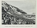
[edit]Cape Adare is the site of the largest Adélie penguin rookery in the world.[9] The only study of this particular colony was done by George Murray Levick,[9] who was a member of the 1910–13 Scott Antarctic Expedition and observed it for an entire breeding cycle in 1911 and 1912.[10] He was reluctant to publish it due to the unusual mating habits of penguins that he recorded, among them homosexuality, sexual and physical abuse of chicks, and mating with dead female penguins, nowadays ascribed to the lack of experience of young penguins.[10] He described it as "depraved". The report was considered too shocking for public release at the time, and was suppressed. The only copies that were made available privately to researchers were translated into Greek, to prevent this knowledge becoming more widely known. After it became lost, it was rediscovered and published in the journal Polar Record only in 2012. The discovery significantly illuminates the behaviour of the species that some researchers[11] believe to be an indicator of climate change.[10]
Important Bird Area
[edit]Over four seasons, sampled between 1981 and 2012, the Adélie colony at Cape Adare had a mean count of 227,000 breeding pairs, making it (along with that at Cape Crozier) among the largest in the Ross Sea. It occupies Ridley Beach and part of the western slopes of the Cape Adare peninsula. A 294 ha site encompassing the colony has been designated an Important Bird Area by BirdLife International. A colony of about 300 pairs of south polar skuas is also present.[12]
In 1901, Carsten Borchgrevink, part of the British Antarctic Expedition 1898–1900, published the book, ‘First on the Antarctic continent’. He wrote ca. 1900, in the chapter dedicated to Adélie penguins:
We all watched the life of the penguins with the utmost interest, and I believe and hope that some of us learnt something from their habits and characteristics.[13]
-
-
 Adélie penguin colony, at their nests


See also
[edit]References
[edit]- ^
 This article incorporates public domain material from "Cape Adare". Geographic Names Information System. United States Geological Survey.
- ^ "Japan cuts short Antarctic whale hunt". NBC News. 2007-02-28. Retrieved 2024-01-08.
- ^ "New Zealand demands Japan urgently move its stricken whaler from Antarctic coast - International Herald Tribune". 2007-03-14. Archived from the original on 2007-03-14. Retrieved 2024-01-08.
- ^ Historic Sites of the Antarctic
- ^ "Cape Adare, Borchgrevink Coast" (PDF). Management Plan for Antarctic Specially Protected Area No. 159: Measure 2, Annex L. Antarctic Treaty Secretariat. 2005. Retrieved 2013-02-06.
- ^ "List of Historic Sites and Monuments approved by the ATCM (2012)" (PDF). Antarctic Treaty Secretariat. 2012. Retrieved 2013-10-27.
- ^ "The last deglaciation of Cape Adare, northern Victoria Land, Antarctica". British Antarctic Survey. 2008.
- ^ Martin, S., Drucker, R., Aster, R., Davey. F., Okal E., Scambos T., and MacAyeal, D., Kinematic and seismic analysis of giant tabular iceberg breakup at Cape Adare, Antarctica, J. Geophys. Res., 115, B06311, doi:10.1029/2009JB006700, 2010
- ^ a b "Shock at sexually 'depraved' penguins led to 100-year censorship". The Week. 10 June 2012. Archived from the original on 23 December 2017. Retrieved 10 June 2012.
- ^ a b c McKie, Robin (9 June 2012). "'Sexual depravity' of penguins that Antarctic scientist dared not reveal". Guardian.co.uk.
- ^ Ainley, David G. (2002). THE ADÉLIE PENGUIN: BELLWETHER OF CLIMATE CHANGE. Columbia University Press. pp. 310 pp. with 23 illustrations, 51 figures, 48 tables, 16 plates. ISBN 0-231-12306-X.
- ^ "Cape Adare". BirdLife Data Zone. BirdLife International. 2015. Retrieved 26 October 2020.
- ^ Carsten Borchgrevink (1901). First on the Antarctic continent: Being an account of the British Antarctic expedition, 1898-1900. p. 210.

External links
[edit]



Cape Adare
View on GrokipediaGeography
Location and Physical Features
Cape Adare is situated at the northern extremity of the Adare Peninsula in Victoria Land, forming the northeasternmost headland on the Borchgrevink Coast along the western margin of the Ross Sea.[1] Its approximate coordinates are 71°18′S 170°11′E, marking the transition from the Ross Sea embayment to the more continental coast of East Antarctica.[1] The cape lies southwest of the Balleny Islands and serves as a prominent geographic marker at the entrance to the Ross Sea, with the Adare Peninsula extending southward approximately 77 kilometers to Cape Roget.[9] Physically, Cape Adare consists of a generally ice-free volcanic headland rising prominently from the sea, characterized by steep basalt cliffs and rocky terrain.[2] The surrounding area features Ridley Beach, a flat shingle foreland located about 1.7 kilometers southwest of the cape proper, which provides accessible terrain amid otherwise rugged slopes.[1] Geologically, it belongs to the North Victoria Land domain, with exposures of volcanic rocks contributing to its dark, rugged appearance and minimal ice cover compared to adjacent glaciated regions.[2] These features create a stark, exposed landscape subject to intense katabatic winds and coastal processes, distinguishing it from the heavily ice-bound expanses typical of much of the Antarctic margin.[1]Geological Context
Cape Adare comprises a headland of Quaternary and possibly late Tertiary alkaline basaltic lavas and pyroclastic deposits, forming steep cliffs and ridges that rise to approximately 800 meters elevation. These volcanic rocks overlie older sedimentary and metamorphic basement of the Robertson Bay Terrane, which includes Paleozoic greywackes and shales intruded by granitoids, though the exposed surface geology is dominated by the Cenozoic volcanics.[10] Xenoliths within the basalts, derived from underlying greywackes, indicate interaction between ascending magma and the Paleozoic substrate during eruption.[11] The cape is part of the Hallett Volcanic Province, a coastal chain of shield volcanoes and eruptive centers extending from Cape Adare southward, associated with extensional tectonics along the Transantarctic Mountains margin.[12] Volcanism here reflects intraplate alkaline magmatism linked to lithospheric thinning and rifting, with eruptions producing olivine basalts and trachytes, often in subaerial to shallow marine environments.[12] K-Ar dating of lavas yields ages spanning the Miocene to Pleistocene, consistent with episodic activity tied to regional uplift and faulting.[12] Tectonically, Cape Adare lies at the northeastern terminus of Victoria Land, proximal to the Adare Basin and Trough—an extinct Tertiary spreading ridge arm that accommodated separation between East and West Antarctica around 44–26 million years ago.[13] This rifting propagated onshore, influencing Neogene faulting and volcanism, as evidenced by aligned brittle faults onshore correlating with offshore magnetic anomalies indicative of thinned crust and magmatic intrusion.[14] The region's geology records a transition from compressional Ross Orogeny (Cambrian–Ordovician) to Cenozoic extension, with the volcanic cap providing a relatively young overlay on this ancient framework.[15]Climate and Environmental Dynamics
Meteorological Conditions
Cape Adare experiences a polar maritime climate characterized by extreme cold, high winds, and low precipitation, typical of coastal Victoria Land influenced by the Ross Sea and katabatic flows from the Transantarctic Mountains.[16] Mean annual air temperatures are estimated around -12.6°C based on reference period data from 1957–1975, with significant seasonal variation; summer (December–February) monthly means rise to near -5°C, while winter (June–August) means drop below -20°C.[16] Historical observations from the 1899 Borchgrevink expedition recorded an August mean of -13.4°F (-25.2°C), underscoring persistent winter severity.[17] Automated weather station data since 2014 confirm ongoing cold conditions, with air temperatures logged every 30 minutes alongside humidity and pressure, though long-term averages remain consistent with early 20th-century records adjusted for regional extrapolation from nearby Hallett Station.[18] Winds dominate the local meteorology, driven by barrier winds along the coast and katabatic drainage from interior ice sheets, frequently exceeding 30 m/s (Beaufort force 10+). Extreme events include sustained hurricane-force gusts (Beaufort 11–12, >32 m/s) lasting days, as documented during early expeditions, eroding loose volcanic material and scouring ice-free terrain.[19] Predominant directions are easterly to northeasterly, modulated by synoptic lows in the Ross Sea, with downslope föhn-like warming occasionally elevating temperatures during barrier wind jets.[20] Recent analyses indicate no significant long-term decline in wind resources near Cape Adare, though seasonal peaks occur in spring and summer.[21] Precipitation is minimal, averaging under 200 mm water equivalent annually, primarily as snow or diamond dust, contributing to the region's aridity despite coastal proximity.[22] Blizzards, often wind-driven rather than from active snowfall, reduce visibility and complicate surface conditions, while persistent cloud cover limits solar radiation, exacerbating low insolation in winter.[23] Variability is high, with occasional warm anomalies linked to blocking highs or Ross Ice Shelf air streams, but overall trends show stability in core parameters amid broader Antarctic cooling in some coastal sectors.[16]Interactions with Ice Features
Cape Adare's rocky promontory and basalt cliffs serve as key pinning points for landfast sea ice in the western Ross Sea, where fast ice attaches directly to coastal features and extends seaward, stabilizing against pack ice drift. This attachment creates recurring fast ice sheets, particularly in the oceanic lee east of the cape, which shelter the area from prevailing westward ice motion along the Antarctic coast.[24][25] Seasonal and interannual variability in fast ice extent around the cape is driven by interactions with regional winds and ocean currents, with maximum coverage in winter and late spring, often abutting nearby floating glaciers and ice tongues between Cape Adare and the McMurdo Ice Shelf. Katabatic winds from the Antarctic interior can push sea ice offshore, promoting polynya formation and enhancing ocean-atmosphere heat fluxes, while the cape's topography modulates local ice accumulation and breakup.[26][27][24] Sea ice dynamics at Cape Adare contribute to broader Ross Sea processes, including brine rejection during formation, which generates dense shelf waters influencing regional circulation and nutrient upwelling. Ice flux estimates through gates between Cape Adare and Land Bay reveal net export variability tied to the Southern Annular Mode, with passive microwave data from 1992 onward showing area fluxes modulated by deformation and drift patterns. Glacier terminus fluctuations southward from the cape, observed as proxies for snowfall changes, indirectly link to sea ice stability via shared climatic forcings, though the cape itself remains largely ice-free due to its low elevation and exposure.[27][28][29][30]Exploration History
Discovery and Early Mapping
Cape Adare was first sighted in January 1841 by Captain James Clark Ross during the British Antarctic Expedition aboard HMS Erebus and HMS Terror. Ross named the prominent headland after his friend Viscount Adare, a British politician and patron of science. Although the expedition charted approximately 900 kilometers of new coastline in Victoria Land, including the vicinity of Cape Adare, strong winds and high surf prevented any landing at the site.[31][32] The first confirmed landing on the Antarctic mainland occurred at Cape Adare on January 24, 1895, when seven crew members from the Norwegian whaling vessel Antarctic, under the command of Henrik Bull and including Carsten Borchgrevink, rowed ashore. This brief visit, lasting about four hours, allowed initial ground observations of the rocky promontory and its surrounding ice features, marking a key step beyond ship-based sighting and rudimentary coastal mapping. The landing party collected rock samples and noted the presence of bird life, contributing to early knowledge of the site's accessibility despite its exposure to northerly winds.[33][3] Subsequent voyages in the late 1890s built on these efforts, with Borchgrevink's selection of Cape Adare for the 1898–1900 Southern Cross Expedition relying on the 1895 landing's confirmation of a relatively ice-free beach suitable for operations. Early charts from Ross's era depicted Cape Adare as a bold coastal projection, while the 1895 visit provided the first on-site verification, aiding more precise positional fixes relative to the Ross Sea.[3][34]Major Expeditions and Overwinterings
The first major expedition to overwinter at Cape Adare was the British Antarctic Expedition led by Carsten E. Borchgrevink, which arrived aboard the Southern Cross on 17 February 1899.[35] The team of ten men constructed two prefabricated huts on a beach ridge starting 20 February 1899, marking the initial permanent structures erected on the Antarctic continent.[36] These served as quarters for the overwintering party from March 1899 until their relief in January 1900, representing the earliest documented intentional overwintering south of the Antarctic Circle.[37] During this period, the expedition conducted meteorological observations, geological surveys, and biological studies amid extreme conditions, including blizzards and temperatures dropping to -50°C.[3] The next significant overwintering occurred during Robert Falcon Scott's Terra Nova Expedition (1910–1913), when the Northern Party under Victor Campbell landed on 18 February 1911 with six members.[38] They erected a third hut approximately 30 meters north of Borchgrevink's structures to support their winter base.[2] The party endured the 1911 Antarctic winter at Cape Adare, performing scientific work including geological mapping and collection of rock samples before sledge journeys northward in late 1911.[39] Unable to be retrieved by ship due to ice conditions, the group relocated and survived a second unplanned winter in an ice cave on Robertson Bay, but their initial overwintering at Cape Adare advanced knowledge of the region's terrain and resources.[36]Stranding Incidents and Rescues
During Robert Falcon Scott's Terra Nova Expedition (1910–1913), the Northern Party—comprising six men led by Victor Campbell, along with George Murray Levick, Raymond Priestley, Harry Dickason, Frank Browning, and Morton Hoyt—was landed at Cape Adare on 18 February 1911 to conduct geological, meteorological, and biological surveys along the western coast of Victoria Land for one austral summer season.[38] The party established a base by constructing a prefabricated hut adjacent to the existing structures from Carsten Borchgrevink's 1899–1900 expedition, approximately 30 meters north of Borchgrevink's main hut.[2] The intended pickup by the expedition ship Terra Nova failed in January 1912 due to impenetrable pack ice blocking access to Robertson Bay and the approaches to Cape Adare, stranding the group for an unplanned overwintering.[38] With provisions limited to seal and penguin meat supplemented by stored supplies, the men endured the 1912 winter in their hut amid blizzards and temperatures dropping to -40°C, while continuing observations of the local Adélie penguin colony and coastal geology; Levick documented penguin behavior in detail, producing the first systematic study of the species.[38] No immediate rescue was possible, as the Terra Nova could not penetrate the ice despite multiple attempts coordinated from the main base at Cape Evans.[40] Facing a second winter with depleting resources and to avoid the intensifying penguin guano hazards at Cape Adare, the party departed on 22 September 1912, sledging southward approximately 250 miles (400 km) along the Barrier edge and coastal ice to Inexpressible Island in Terra Nova Bay, where they excavated an ice cave for shelter during the 1912–1913 winter.[38] [41] Rations were rationed to minimal levels—primarily pemmican, biscuit, and occasional seal—resulting in significant physical strain, though all survived without frostbite or scurvy due to fresh meat consumption. In spring 1912, they initiated a 230-mile (370 km) overland march south to Cape Evans, man-hauling sledges through crevassed terrain and arriving on 7 November 1912, where they integrated with the main expedition party amid news of Scott's polar failure.[41] This self-orchestrated return constituted the effective resolution of the stranding, with the Terra Nova later repatriating the full expedition in 1913; no fatalities occurred in the Northern Party, underscoring their resourcefulness despite the absence of external intervention.[38] No other documented stranding incidents requiring rescue have occurred at Cape Adare, though the site's remote location and ice dynamics have historically amplified risks during early 20th-century operations.[38] Borchgrevink's earlier overwintering (1899–1900) was intentional and successfully concluded with ship relief in January 1900, distinguishing it from unintended events.[5]Preservation of Historic Structures
The historic structures at Cape Adare consist of two prefabricated wooden huts erected by the British Antarctic Expedition (1898–1900) under Carsten Borchgrevink, marking the first buildings constructed on the Antarctic continent.[5] The living hut and stores hut, each measuring approximately 5.5 by 6.5 meters, were built from Norwegian spruce on Ridley Beach in early February 1900 to support the first overwintering party south of the Antarctic Circle.[5] These structures later served the Northern Party of Robert Falcon Scott's British Antarctic Expedition (1910–1913) during their involuntary overwintering in 1911.[35] Designated as Historic Site and Monument (HSM) No. 22 under the Antarctic Treaty System in 1966, the huts and associated artifacts are protected to preserve their role in early polar exploration history.[6] Preservation efforts began in earnest with the Antarctic Heritage Trust New Zealand (AHT), which first visited the site in 1990 to undertake stabilization works on the deteriorating structures threatened by ice pressure, wind erosion, and accumulation of Adélie penguin guano.[36] The huts form part of Antarctic Specially Protected Area (ASPA) No. 159, established to safeguard the site's ecological and historical values, with management plans mandating periodic conservation programs including artifact cataloging and structural repairs.[42] AHT's interventions have focused on removing ice buildup, reinforcing walls, and conserving internal relics such as expedition equipment and provisions, while adhering to minimal intervention principles to retain authenticity.[36] Challenges to preservation include the site's remoteness, harsh weather limiting access to austral summers, and biological pressures from the nearby Adélie penguin colony, which deposits corrosive guano and disrupts artifacts.[43] Despite these, AHT conducted ongoing maintenance during the 2021–2022 season, stabilizing roofs and clearing debris, and planned further works for the 2024–2025 season involving teams addressing structural vulnerabilities.[44] Visitor guidelines enforced by the Antarctic Treaty prohibit disturbance of historic features, require removal of all waste, and limit access to protect the fragile remains.[1] These measures ensure the huts' longevity as tangible links to the Heroic Age of Antarctic Exploration.[36]Biological Significance
Adélie Penguin Population
Cape Adare, Antarctica, supports one of the largest colonies of Adélie penguins (Pygoscelis adeliae), primarily on Ridley Beach and adjacent slopes. The colony was established approximately 2000 years before present (BP, calibrated to 1950 CE).[7] Radiocarbon dating of guano layers and ornithogenic soils indicates an ancient "supercolony" that peaked at around 500,000 breeding pairs circa 1200 BP, before declining to lower levels after approximately 800 BP for reasons not fully elucidated, possibly related to environmental shifts.[7] Modern estimates of breeding pairs at Cape Adare vary due to differences in survey methods, such as ground counts versus satellite imagery. A 2012 ground count recorded 227,000 breeding pairs, while 2014 satellite analysis yielded 338,231 pairs.[7] Visitor guidelines from the Antarctic Treaty Secretariat report approximately 500,000 breeding pairs as of 2018, affirming its status as a key site for the species despite potential fluctuations influenced by sea ice dynamics and food availability.[1] These numbers represent a substantial portion of the regional Adélie population in the Ross Sea sector, underscoring the site's ecological importance.[7]Other Wildlife and Ecosystem Role
South polar skuas (Stercorarius maccormicki), numbering approximately 300 breeding pairs, nest on the slopes above the Adélie penguin colony at Cape Adare, primarily preying on penguin eggs and chicks during the breeding season.[1][45] These birds contribute to population regulation within the penguin rookery through kleptoparasitism and direct predation, with colony sizes fluctuating in response to prey availability.[46] Weddell seals (Leptonychotes weddellii) frequently haul out on Ridley Beach near the penguin nesting grounds, with regional estimates indicating tens of thousands in the western Ross Sea sector encompassing Cape Adare.[47] Ross seals (Ommatophoca rossii) occasionally appear on nearby ice floes, while Antarctic fur seals (Arctocephalus gazella) visit sporadically.[48][34] These pinnipeds forage in adjacent waters, targeting fish and krill, but do not maintain breeding colonies at the site. The Adélie penguin supercolony at Cape Adare drives significant nutrient cycling, depositing guano that forms ornithogenic soils enriched with nitrogen and phosphorus, fostering microbial communities and limited terrestrial vegetation such as mosses in an otherwise oligotrophic environment.[49] This sea-to-land nutrient flux supports localized biodiversity, including invertebrates and detritivores, while predators like skuas recycle biomass back into marine systems via scavenging.[50] Seals further enhance coastal productivity by transporting oceanic nutrients ashore during haul-outs.[50] The site's role as an Important Bird and Biodiversity Area underscores its function in sustaining Ross Sea trophic dynamics, with penguin guano deposits influencing sediment geochemistry over millennia.[45]Long-Term Population Records
The Adélie penguin colony at Cape Adare exhibits one of the longest continuous occupation histories in Antarctica, with evidence of breeding activity dating back approximately 2000 years before present (BP), based on radiocarbon dating of eggshells and ornithogenic soils from Ridley Beach mounds.[7] Proxy records from sediment cores indicate earlier intermittent occupation from about 45,000 to 27,000 radiocarbon years BP, followed by recolonization around 8000 calibrated years BP after glacial retreat, with abandonments during cooling periods between 5000–4000 and 2000–1100 calibrated years BP linked to reduced sea ice and marine productivity.[8] The colony expanded significantly around 1700 BP to occupy upper terraces, peaking near 1200 BP as a "supercolony" estimated at roughly 500,000 breeding pairs across 0.78 km², inferred from guano accumulation rates, bone densities, and radiocarbon-dated remains including eggshells averaging 1386 BP.[7] Decline set in post-1200 BP, with upper terrace abandonment by ~800 BP, possibly due to climatic shifts or resource competition, reducing the active area while Ridley Beach remained occupied.[7] Early 20th-century expeditions provided initial direct observations but limited quantitative counts. During the British Antarctic Expedition (1901–1904), George Murray Levick documented a full breeding cycle over three months in 1911–1912, noting dense nesting on Ridley Beach amid guano-covered slopes, though without precise pair estimates.[51] Carsten Borchgrevink's Southern Cross Expedition (1898–1900) similarly recorded vast colonies but focused on qualitative descriptions of hundreds of thousands of birds.[34] Modern surveys, aided by aerial photography and satellite imagery, reveal fluctuations but overall stability or modest growth in the Ross Sea region. Ground and remote counts from 1981–2012 averaged over 300,000 breeding pairs, with a 2014 satellite estimate of 338,231 pairs.[7] Subsequent assessments reported approximately 504,332 pairs in the late 2010s, positioning Cape Adare as Antarctica's largest Adélie colony, comprising about 13–15% of the species' Ross Sea population.[52] Unlike declines in warming Antarctic Peninsula colonies, East Antarctic sites like Cape Adare have shown increases tied to stable or expanding sea ice, with a 3.3% annual growth rate noted in northern Ross Sea populations through the 1980s–1990s.[53] Ongoing monitoring via the Commission for the Conservation of Antarctic Marine Living Resources tracks these trends against environmental variables, though guano layers suggest the current size remains below the medieval peak.[7]| Period | Estimated Breeding Pairs | Evidence/Source |
|---|---|---|
| ~1200 BP (peak) | ~500,000 | Radiocarbon-dated guano, bones, eggshells; soil proxies[7] |
| 1981–2012 (mean) | >300,000 | Aerial/ground surveys[7] |
| 2014 | 338,231 | Satellite imagery[7] |
| Late 2010s | 504,332 | Field counts[52] |