
Community hub
Recent from talks
Contribute something
Nothing was collected or created yet.
Continent
View on Wikipedia

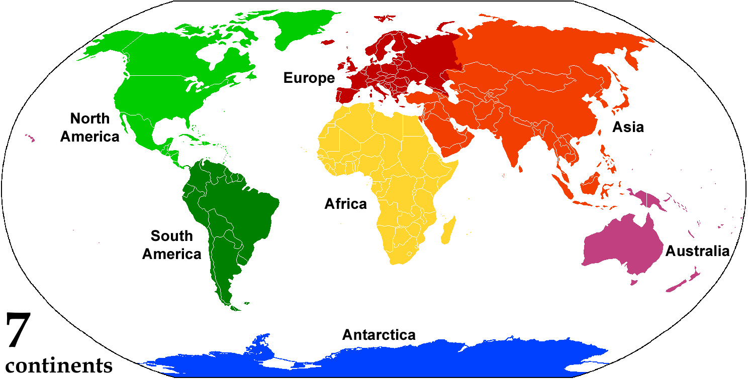
A continent is any of several large terrestrial geographical regions. Continents are generally identified by convention rather than any strict criteria. A continent could be a single large landmass, a part of a very large landmass, as in the case of Asia or Europe within Eurasia, or a landmass and nearby islands within its continental shelf. Due to these varying definitions, the number of continents varies; up to seven or as few as four geographical regions are commonly regarded as continents. Most English-speaking countries recognize seven regions as continents. In order from largest to smallest in area, these seven regions are Asia, Africa, North America, South America, Antarctica, Europe, and Australia (sometimes called Oceania or Australasia). Different variations with fewer continents merge some of these regions; examples of this are merging Asia and Europe into Eurasia,[1] North America and South America into the Americas (or simply America), and Africa, Asia, and Europe into Afro-Eurasia.
Oceanic islands are occasionally grouped with a nearby continent to divide all the world's land into geographical regions. Under this scheme, most of the island countries and territories in the Pacific Ocean are grouped together with the continent of Australia to form the geographical region of Oceania.[2]
In geology, a continent is defined as "one of Earth's major landmasses, including both dry land and continental shelves".[3] The geological continents correspond to seven large areas of continental crust that are found on the tectonic plates, but exclude small continental fragments such as Madagascar that are generally referred to as microcontinents. Continental crust is only known to exist on Earth.[4]
The idea of continental drift gained recognition in the 20th century. It postulates that the current continents formed from the breaking up of a supercontinent (Pangaea) that formed hundreds of millions of years ago.
Etymology
[edit]From the 16th century the English noun continent was derived from the term continent land, meaning continuous or connected land[5] and translated from the Latin terra continens.[6] The noun was used to mean "a connected or continuous tract of land" or mainland.[5] It was not applied only to very large areas of land—in the 17th century, references were made to the continents (or mainlands) of the Isle of Man, Ireland and Wales and in 1745 to Sumatra.[5] The word continent was used in translating Greek and Latin writings about the three "parts" of the world, although in the original languages no word of exactly the same meaning as continent was used.[7]
While continent was used on the one hand for relatively small areas of continuous land, on the other hand geographers again raised Herodotus's query about why a single large landmass should be divided into separate continents. In the mid-17th century, Peter Heylin wrote in his Cosmographie that "A Continent is a great quantity of Land, not separated by any Sea from the rest of the World, as the whole Continent of Europe, Asia, Africa." In 1727, Ephraim Chambers wrote in his Cyclopædia, "The world is ordinarily divided into two grand continents: the Old and the New." And in his 1752 atlas, Emanuel Bowen defined a continent as "a large space of dry land comprehending many countries all joined together, without any separation by water. Thus Europe, Asia, and Africa is one great continent, as America is another."[8] However, the old idea of Europe, Asia and Africa as "parts" of the world ultimately persisted with these being regarded as separate continents.
Definitions and application
[edit]By convention, continents "are understood to be large, continuous, discrete masses of land, ideally separated by expanses of water".[9] By this definition, all continents have to be an island of some metric. In modern schemes with five or more recognized continents, at least one pair of continents is joined by land in some fashion. The criterion "large" leads to arbitrary classification: Greenland, with a surface area of 2,166,086 square kilometres (836,330 sq mi), is only considered the world's largest island, while Australia, at 7,617,930 square kilometres (2,941,300 sq mi), is deemed the smallest continent.
Earth's major landmasses all have coasts on a single, continuous World Ocean, which is divided into several principal oceanic components by the continents and various geographic criteria.[10][11]
The geological definition of a continent has four criteria: high elevation relative to the ocean floor; a wide range of igneous, metamorphic and sedimentary rocks rich in silica; a crust thicker than the surrounding oceanic crust; and well-defined limits around a large enough area.[12]
Extent
[edit]The most restricted meaning of continent is that of a continuous[13][non-tertiary source needed] area of land or mainland, with the coastline and any land boundaries forming the edge of the continent. In this sense, the term continental Europe (sometimes referred to in Britain as "the Continent") is used to refer to mainland Europe, excluding islands such as Great Britain, Iceland, Ireland, and Malta, while the term continent of Australia may refer to the mainland of Australia, excluding New Guinea, Tasmania, and other nearby islands. Similarly, the continental United States refers to "the 49 States (including Alaska but excluding Hawaii) located on the continent of North America, and the District of Columbia."[14]
From the perspective of geology or physical geography, continent may be extended beyond the confines of continuous dry land to include the shallow, submerged adjacent area (the continental shelf)[15] and the islands on the shelf (continental islands), as they are structurally part of the continent.[16]
From this perspective, the edge of the continental shelf is the true edge of the continent, as shorelines vary with changes in sea level.[17] In this sense the islands of Great Britain and Ireland are part of Europe, while Australia and the island of New Guinea together form a continent. Taken to its limit, this view could support the view that there are only three continents: Antarctica, Australia-New Guinea, and a single mega-continent which joins Afro-Eurasia and America via the contiguous continental shelf in and around the Bering Sea. The vast size of the latter compared to the first two might even lead some to say it is the only continent, the others being more comparable to Greenland or New Zealand.[12]

As a cultural construct, the concept of a continent may go beyond the continental shelf to include oceanic islands and continental fragments. In this way, Iceland is considered a part of Europe, and Madagascar a part of Africa. Extrapolating the concept to its extreme, some geographers group the Australian continental landmass with other islands in the Pacific Ocean into Oceania, which is usually considered a region rather than a continent. This divides the entire land surface of Earth into continents, regions, or quasi-continents.[18]
Separation
[edit]The criterion that each continent is a discrete landmass is commonly relaxed due to historical conventions and practical use. Of the seven most globally recognized continents, only Antarctica and Australia are completely separated from other continents by the ocean. Several continents are defined not as absolutely distinct bodies but as "more or less discrete masses of land".[19] Africa and Asia are joined by the Isthmus of Suez, and North America and South America by the Isthmus of Panama. In both cases, there is no complete separation of these landmasses by water (disregarding the Suez Canal and the Panama Canal, which are both narrow and shallow, as well as human-made). Both of these isthmuses are very narrow compared to the bulk of the landmasses they unite.
North America and South America are treated as separate continents in the seven-continent model. However, they may also be viewed as a single continent known as America. This viewpoint was common in the United States until World War II, and remains prevalent in some Asian and most Latin American six-continent models.[20] The single American continent model also remains a common view in European countries like France, Greece, Hungary, Italy, Malta, Portugal, and Spain, as well as in some Asian countries and most Latin American countries.
The criterion of a discrete landmass is completely disregarded if the continuous landmass of Eurasia is classified as two separate continents (Asia and Europe). Physiographically, Europe and the Indian subcontinent are large peninsulas of the Eurasian landmass. However, Europe is considered a continent with its comparatively large land area of 10,180,000 square kilometres (3,930,000 sq mi), while the Indian subcontinent, with less than half that area, is considered a subcontinent. The alternative view—in geology and geography—that Eurasia is a single continent results in a six-continent view of the world. Some view the separation of Eurasia into Asia and Europe as a residue of Eurocentrism: "In physical, cultural and historical diversity, China and India are comparable to the entire European landmass, not to a single European country. [...]."[21] However, for historical and cultural reasons, the view of Europe as a separate continent continues in almost all categorizations.
If continents are defined strictly as discrete landmasses, embracing all the contiguous land of a body, then Africa, Asia, and Europe form a single continent which may be referred to as Afro-Eurasia.[22] Combined with the consolidation of the Americas, this would produce a four-continent model consisting of Afro-Eurasia, America, Antarctica, and Australia.
When sea levels were lower during the Pleistocene ice ages, greater areas of the continental shelf were exposed as dry land, forming land bridges between Tasmania and the Australian mainland.[23] At those times, Australia and New Guinea were a single, continuous continent known as Sahul. Likewise, Afro-Eurasia and the Americas were joined by the Bering Land Bridge. Other islands, such as Great Britain, were joined to the mainlands of their continents. At that time, there were just three discrete landmasses in the world: Africa-Eurasia-America, Antarctica, and Australia-New Guinea (Sahul).
Number
[edit]There are several ways of distinguishing the continents:

Similar shades exhibit areas that may be consolidated or subdivided.
| Number | Continents | Sources | Comment | ||||||
|---|---|---|---|---|---|---|---|---|---|
| Four | Afro-Eurasia (Old World or World Island) | America (New World) | Antarctica | Australia | [24][25][26][27][28][29][30][31] | Continuous landmasses | |||
| Five | Africa | Eurasia | America | Antarctica | Australia | [32][33][34] | Physiographic regions | ||
| Six | Africa | Eurasia | North America | South America | Antarctica | Australia | [35][36] | Geological continents | |
| Africa | Asia | Europe | America | Antarctica | Australia | [37] | UNSD continental regions | ||
| Seven | Africa | Asia | Europe | North America | South America | Antarctica | Australia | [35][38][39][40][41][42] | "Parts" of the world |
- The seven-continent model is taught in most English-speaking countries, including Australia,[43] Canada, the United Kingdom,[44] and the United States, and also in Bangladesh, China, India, Indonesia, Pakistan, the Philippines, Sri Lanka, Suriname, parts of Europe and Africa.
- The six-continent combined-Eurasia model is mostly used in Russia and some parts of Eastern Europe.[45][46]
- The six-continent combined-America model is taught in Greece and many Romance-speaking countries—including Latin America.[37]
- The Olympic flag's five rings represent the five inhabited continents of the combined-America model but exclude the uninhabited Antarctica.[47]
In the English-speaking countries, geographers often use the term Oceania to denote a geographical region which includes most of the island countries and territories in the Pacific Ocean, as well as the continent of Australia.[48] Outside of the English-speaking world, Oceania is generally considered a continent, while Mainland Australia is regarded as its continental landmass.[49][50][51][52]
Eighth continent
[edit]Zealandia (a submerged continent) has been called the eighth continent.[53]
Area and population
[edit]
The following table provides areas given by the Encyclopædia Britannica for each continent in accordance with the seven-continent model, including Australasia along with Melanesia, Micronesia, and Polynesia as parts of Oceania. It also provides populations of continents according to 2021 estimates by the United Nations Statistics Division based on the United Nations geoscheme, which includes all of Egypt (including the Isthmus of Suez and the Sinai Peninsula) as a part of Africa, all of Armenia, Azerbaijan, Cyprus, Georgia, Indonesia (including Western New Guinea,) Kazakhstan, and Turkey (including East Thrace) as parts of Asia, all of Russia (including Siberia) as a part of Europe, all of Panama and the United States (including Hawaii) as parts of North America, and all of Chile (including Easter Island) as a part of South America.
| Continent | Land area[54][55][56][57][58][59][60][61] | Population[62][63] | |||
|---|---|---|---|---|---|
| km2 | mi2 | % of world |
2021 (estimate) |
% of world | |
| Earth | 149,733,926 | 57,812,592 | 100.0 | 7,909,295,151 | 100.0 |
| Asia | 44,614,000 | 17,226,000 | 29.8 | 4,694,576,167 | 59.4 |
| Africa | 30,365,000 | 11,724,000 | 20.3 | 1,393,676,444 | 17.6 |
| North America | 24,230,000 | 9,360,000 | 16.2 | 595,783,465 | 7.5 |
| South America | 17,814,000 | 6,878,000 | 11.9 | 434,254,119 | 5.5 |
| Antarctica | 14,200,000 | 5,500,000 | 9.5 | 0 | 0 |
| Europe | 10,000,000 | 3,900,000 | 6.7 | 745,173,774 | 9.4 |
| Oceania[α] | 8,510,926 | 3,286,087 | 5.7 | 44,491,724 | 0.6 |
- ^ Not usually considered to be a continent in the English-speaking world. Its land area and population includes Australia, New Zealand, and Papua New Guinea, but excludes the Aru Islands and Western New Guinea.
Other divisions
[edit]Supercontinents
[edit]
Apart from the current continents, the scope and meaning of the term continent includes past geological ones. Supercontinents, largely in evidence earlier in the geological record, are landmasses that comprise most of the world's cratons or continental cores.[64] These have included Vaalbara, Kenorland, Columbia, Rodinia, Pannotia, and Pangaea. Over time, these supercontinents broke apart into large landmasses which formed the present continents.
Subcontinents
[edit]
Certain parts of continents are recognized as subcontinents, especially the large peninsulas separated from the main continental landmass by geographical features. The most widely recognized example is the Indian subcontinent.[65] The Arabian Peninsula, Southern Africa, the Southern Cone of South America, and Alaska in North America might be considered further examples.[65][66]
In many of these cases, the "subcontinents" concerned are on different tectonic plates from the rest of the continent, providing a geological justification for the terminology.[67] Greenland, generally considered the world's largest island on the northeastern periphery of the North American Plate, is sometimes referred to as a subcontinent.[68][69] This is a significant departure from the more conventional view of a subcontinent as comprising a very large peninsula on the fringe of a continent.[65]
Where the Americas are viewed as a single continent (America), it is divided into two subcontinents (North America and South America)[70][71][72] or three (Central America being the third).[73][74] When Eurasia is regarded as a single continent, Asia and Europe are treated as subcontinents.[65]
Submerged continents
[edit]
Some areas of continental crust are largely covered by the ocean and may be considered submerged continents. Notable examples are Zealandia, emerging from the ocean primarily in New Zealand and New Caledonia,[75][non-tertiary source needed] and the almost completely submerged Kerguelen Plateau in the southern Indian Ocean.[76]
Microcontinents
[edit]Some islands lie on sections of continental crust that have rifted and drifted apart from a main continental landmass. While not considered continents because of their relatively small size, they may be considered microcontinents. Madagascar, the largest example, is usually considered an island of Africa, but its divergent evolution has caused it to be referred to as "the eighth continent" from a biological perspective.[77]
Geological continents
[edit]Geologists use four key attributes to define a continent:[78]
- Elevation – The landmass, whether dry or submerged beneath the ocean, should be elevated above the surrounding ocean crust.
- Geology – The landmass should contain different types of rock: igneous, metamorphic, and sedimentary.
- Crustal structure – The landmass should consist of the continental crust, which is thicker and has a lower seismic velocity than the oceanic crust.
- Limits and area – The landmass should have clearly defined boundaries and an area of more than one million square kilometres.[a]
With the addition of Zealandia in 2017, Earth currently has seven recognized geological continents:
Due to a seeming lack of Precambrian cratonic rocks, Zealandia's status as a geological continent has been disputed by some geologists.[80] However, a study conducted in 2021 found that part of the submerged continent is indeed Precambrian, twice as old as geologists had previously thought, which is further evidence that supports the idea of Zealandia being a geological continent.[81][82]
All seven geological continents are spatially isolated by geologic features.[83]
History of the concept
[edit]Early concepts of the Old World continents
[edit]
The term "continent" translates the Greek word ἤπειρος, meaning "landmass, terra firma", the proper name of Epirus and later especially used for Asia (i.e. Asia Minor).[84]
The first distinction between continents was made by ancient Greek mariners who gave the names Europe and Asia to the lands on either side of the waterways of the Aegean Sea, the Dardanelles strait, the Sea of Marmara, the Bosporus strait and the Black Sea.[85] The names were first applied just to lands near the coast and only later extended to include the hinterlands.[86][87] But the division was only carried through to the end of navigable waterways and "... beyond that point the Hellenic geographers never succeeded in laying their finger on any inland feature in the physical landscape that could offer any convincing line for partitioning an indivisible Eurasia ..."[85]
Ancient Greek thinkers subsequently debated whether Africa (then called Libya) should be considered part of Asia or a third part of the world. Division into three parts eventually came to predominate.[88] From the Greek viewpoint, the Aegean Sea was the center of the world; Asia lay to the east, Europe to the north and west, and Africa to the south.[89] The boundaries between the continents were not fixed. Early on, the Europe–Asia boundary was taken to run from the Black Sea along the Rioni River (known then as the Phasis) in Georgia. Later it was viewed as running from the Black Sea through Kerch Strait, the Sea of Azov and along the Don River (known then as the Tanais) in Russia.[90] The boundary between Asia and Africa was generally taken to be the Nile River. Herodotus[91] in the 5th century BCE objected to the whole of Egypt being split between Asia and Africa ("Libya") and took the boundary to lie along the western border of Egypt, regarding Egypt as part of Asia.[92][93][94][95] He also questioned the division into three of what is really a single landmass,[96] a debate that continues nearly two and a half millennia later. Herodotus believed Europe to be larger (at least in width) than the other two continents:
I wonder, then, at those who have mapped out and divided the world into Libya, Asia, and Europe; for the difference between them is great, seeing that in length Europe stretches along both the others together, and it appears to me to be wider beyond all comparison.[97]
Eratosthenes, in the 3rd century BCE, noted that some geographers divided the continents by rivers (the Nile and the Don), thus considering them "islands". Others divided the continents by isthmuses, calling the continents "peninsulas". These latter geographers set the border between Europe and Asia at the isthmus between the Black Sea and the Caspian Sea, and the border between Asia and Africa at the isthmus between the Red Sea and the mouth of Lake Bardawil on the Mediterranean Sea.[98]
The Roman author Pliny the Elder, writing in the 1st century CE, stated that "The whole globe is divided into three parts, Europe, Asia, and Africa", adding:
I shall first then speak of Europe, the foster-mother of that people which has conquered all other nations, and itself by far the most beauteous portion of the earth. Indeed, many persons have, not without reason, considered it, not as a third part only of the earth, but as equal to all the rest, looking upon the whole of our globe as divided into two parts only, by a line drawn from the river Tanais to the Straits of Gades.[99]

Following the fall of the Western Roman Empire, the culture that developed in its place, linked to Latin and the Catholic church, began to associate itself with the concept of Europe.[87] Through the Roman period and the Middle Ages, a few writers took the Isthmus of Suez as the boundary between Asia and Africa, but most writers continued to consider it the Nile or the western border of Egypt (Gibbon).[citation needed] In the Middle Ages, the world was usually portrayed on T and O maps, with the T representing the waters dividing the three continents. By the middle of the 18th century, "the fashion of dividing Asia and Africa at the Nile, or at the Great Catabathmus [the boundary between Egypt and Libya] farther west, had even then scarcely passed away".[100]
European arrival in the Americas
[edit]Christopher Columbus sailed across the Atlantic Ocean to the Caribbean in 1492, sparking a period of European exploration of the Americas. But despite four voyages to the Americas, Columbus never believed he had reached a new continent—he always thought it was part of Asia.
In 1501, Amerigo Vespucci and Gonçalo Coelho attempted to sail around what they considered the southern end of the Asian mainland into the Indian Ocean, passing through Fernando de Noronha. After reaching the coast of Brazil, they sailed along the coast of South America much farther south than Asia was known to extend, confirming that this was a land of continental proportions.[101] On return to Europe, an account of the voyage, called Mundus Novus ("New World"), was published under Vespucci's name in 1502 or 1503,[102] although it seems that it had additions or alterations by another writer.[103] Regardless of who penned the words, Mundus Novus credited Vespucci with saying, "I have discovered a continent in those southern regions that is inhabited by more numerous people and animals than our Europe, or Asia or Africa",[104] the first known explicit identification of part of the Americas as a continent like the other three.
Within a few years, the name "New World" began appearing as a name for South America on world maps, such as the Oliveriana (Pesaro) map of around 1504–1505. Maps of this time, though, still showed North America connected to Asia and showed South America as a separate land.[103]

In 1507 Martin Waldseemüller published a world map, Universalis Cosmographia, which was the first to show North and South America as separate from Asia and surrounded by water. A small inset map above the main map explicitly showed for the first time the Americas being east of Asia and separated from Asia by an ocean, as opposed to just placing the Americas on the left end of the map and Asia on the right end. In the accompanying book Cosmographiae Introductio, Waldseemüller noted that the earth is divided into four parts, Europe, Asia, Africa, and the fourth part, which he named "America" after Amerigo Vespucci's first name.[105] On the map, the word "America" was placed on part of South America.
Beyond four continents
[edit]The Sanskrit text Rig Veda often dated 1500 BCE[note 1] has the earliest mention of seven continents in the Earth, the text claims that the Earth has seven continents and Lord Vishnu Measured the entire universe from his first foot from the land of Earth which has 7 continents.[112]
ato devā avantu no yato viṣṇurvicakrame |
pṛthivyāḥ saptadhāmabhiḥ ||
idaṃ viṣṇurvi cakrame tredhā ni dadhe padam |
samūḷhamasya pāṃsure ||
trīṇi padā vi cakrame viṣṇurghopā adābhyaḥ |
ato dharmāṇi dhārayan ||
The Gods be gracious unto us even from the place whence Vishnu strode
Through the seven regions of the earth!
Through all this world strode Vishnu; thrice his foot he planted, and the whole
Was gathered in his footstep's dust.
Vishnu, the Guardian, he whom none deceiveth, made three steps; thenceforth
Establishing his high decrees.

In regard to the above-quoted verses, it is commonly accepted that there are Seven Continents or 'regions of the earth'. A. Glucklich adds that 'In the Matsya Purana, for instance, there is a seven-part map of the world ... [it has] one centre, where an immense mountain – Mount Meru (or Maha Meru, Great Meru) – stands ... The continents encircle the mountain in seven concentric circles ... It seems clear that the Himalayas were the approximate location of Mt. Meru and the text is clear that the earth has seven continents.[112]

From the late 18th century, some geographers started to regard North America and South America as two parts of the world, making five parts in total. Overall though, the fourfold division prevailed well into the 19th century.[115]
Europeans discovered Australia in 1606, but for some time it was taken as part of Asia. By the late 18th century, some geographers considered it a continent in its own right, making it the sixth (or fifth for those still taking America as a single continent).[115] In 1813, Samuel Butler wrote of Australia as "New Holland, an immense island, which some geographers dignify with the appellation of another continent" and the Oxford English Dictionary was just as equivocal some decades later.[116] It was in the 1950s that the concept of Oceania as a "great division" of the world was replaced by the concept of Australia as a continent.[117]
Antarctica was sighted in 1820 during the First Russian Antarctic Expedition and described as a continent by Charles Wilkes on the United States Exploring Expedition in 1838, the last continent identified, although a great "Antarctic" (antipodean) landmass had been anticipated for millennia. An 1849 atlas labelled Antarctica as a continent but few atlases did so until after World War II.[118]
Over time, the western concept of dividing the world into continents spread globally, replacing conceptions in other areas of the world. The idea of continents continued to become imbued with cultural and political meaning. In the 19th century during the Meiji period, Japanese leaders began to self-identify with the concept of being Asian, and renew relations with other "Asian" countries while conceiving of the idea of Asian solidarity against western countries. This conception of an Asian identity, as well as the idea of Asian solidarity, was later taken up by others in the region, such as Republican China and Vietnam.[119]
From the mid-19th century, atlases published in the United States more commonly treated North and South America as separate continents, while atlases published in Europe usually considered them one continent. However, it was still not uncommon for American atlases to treat them as one continent up until World War II.[120] From the 1950s, most U.S. geographers divided the Americas into two continents.[120] With the addition of Antarctica, this made the seven-continent model. However, this division of the Americas did not appeal to Latin Americans, who saw their region spanning an América as a single landmass, and there the conception of six continents remains popular.
Some geographers regard Europe and Asia together as a single continent, dubbed Eurasia.[121] In this model, the world is divided into six continents, with North America and South America considered separate continents.
Geology
[edit]Geologists use the term continent in a different manner from geographers. In geology, a continent is defined by continental crust, which is a platform of metamorphic and igneous rocks, largely of granitic composition. Continental crust is less dense and much thicker than oceanic crust, which causes it to "float" higher than oceanic crust on the dense underlying mantle. This explains why the continents form high platforms surrounded by deep ocean basins.[122][3]
Some geologists restrict the term continent to portions of the crust built around stable regions called cratons. Cratons have largely been unaffected by mountain-building events (orogenies) since the Precambrian. A craton typically consists of a continental shield surrounded by a continental platform. The shield is a region where ancient crystalline basement rock (typically 1.5 to 3.8 billion years old) is widely exposed at the surface. The platform surrounding the shield is also composed of ancient basement rock, but with a cover of younger sedimentary rock.[123] The continents are accretionary crustal "rafts" that, unlike the denser basaltic crust of the ocean basins, are not subjected to destruction through the plate tectonic process of subduction. This accounts for the great age of the rocks comprising the continental cratons.[124]
The margins of geologic continents are either active or passive. An active margin is characterised by mountain building, either through a continent-on continent collision or a subduction zone. Continents grow by accreting lighter volcanic island chains and microcontinents along these active margins, forming orogens. At a passive margin, the continental crust is stretched thin by extension to form a continental shelf, which tapers off with a gradual slope covered in sediment, connecting it directly to the oceanic crust beyond. Most passive margins eventually transition into active margins: where the oceanic plate becomes too heavy due to cooling, it disconnects from the continental crust, and starts subducting below it, forming a new subduction zone.[125]
.svg)
There are many microcontinents, or continental fragments, that are built of continental crust but do not contain a craton. Some of these are fragments of Gondwana or other ancient cratonic continents: Zealandia,[78] which includes New Zealand and New Caledonia; Madagascar; the northern Mascarene Plateau, which includes the Seychelles. Other islands, such as several in the Caribbean Sea, are composed largely of granitic rock as well, but all continents contain both granitic and basaltic crust, and there is no clear boundary as to which islands would be considered microcontinents under such a definition. The Kerguelen Plateau, for example, is largely volcanic, but is associated with the breakup of Gondwanaland and is considered a microcontinent,[126][127] whereas volcanic Iceland and Hawaii are not. The British Isles, Sri Lanka, Borneo, and Newfoundland were on the margins of the Laurasian continent—only separated from the main continental landmass by inland seas flooding its margins.
The movement of plates has caused the continual formation and breakup of continents, and occasionally supercontinents, in a process called the Wilson Cycle. The supercontinent Columbia or Nuna formed during a period of 2.0–1.8 billion years ago and broke up about 1.5–1.3 billion years ago.[128][129] The supercontinent Rodinia is thought to have formed about 1 billion years ago and to have embodied most or all of Earth's continents, and broken up into eight continents around 600 million years ago. The eight continents later reassembled into another supercontinent called Pangaea; Pangaea broke up into Laurasia (which became North America and Eurasia) and Gondwana (which became the remaining continents).[130]
Criticism
[edit]Some academics, such as the historical geographer Martin W. Lewis, argue that the systems we understand today are more rooted in social, political, and cultural history than in geological fact, a view particularly outlined in his book The Myth of Continents: A Critique of Metageography.[131]
See also
[edit]Notes
[edit]- ^ It is certain that the hymns of the Rig Veda post-date Indo-Iranian separation of c. 2000 BCE and probably that of the relevant Mitanni documents of c. 1400 BCE. Philological estimates tend to date the bulk of the text to the second half of the second millennium:
- Max Müller: "the hymns of the Rig-Veda are said to date from 1500 B.C."[106]
- The EIEC (s.v. Indo-Iranian languages, p. 306) gives 1500–1000 BCE.
- Flood and Witzel both mention c. 1500–1200 BCE.[107][108]
- Anthony mentions c. 1500–1300 BCE.[109]
- Thomas Oberlies (Die Religion des Rgveda, 1998, p. 158) based on 'cumulative evidence' sets a wide range of 1700–1100 BCE.[110] Oberlies 1998, p. 155 gives an estimate of 1100 BCE for the youngest hymns in book 10.[111]
- Witzel 1995, p. 4 mentions c. 1500–1200 BCE. According to Witzel 1997, p. 263, the whole Rig Vedic period may have lasted from c. 1900 BCE to c. 1200 BCE: "the bulk of the RV represents only 5 or 6 generations of kings (and of the contemporary poets) of the Pūru and Bharata tribes. It contains little else before and after this "snapshot" view of contemporary Rgvedic history, as reported by these contemporary "tape recordings." On the other hand, the whole Rgvedic period may have lasted even up to 700 years, from the infiltration of the Indo-Aryans into the subcontinent, c. 1900 B.C. (at the utmost, the time of collapse of the Indus civilization), up to c. 1200 B.C., the time of the introduction of iron which is first mentioned in the clearly post-gvedic hymns of the Atharvaveda."
- ^ In accordance with these attributes, Eurasia and North America are connected by a bridge of continental crust at least 2 thousand kilometers wide. And with Africa, Eurasia is connected by such a bridge (interrupted by internal sections of the oceanic crust) with a width of at least 5 thousand kilometers.
References
[edit]- ^ "Continents: What is a Continent?". National Geographic. 20 September 2011. Archived from the original on 16 July 2019. Retrieved 6 December 2020. "Most people recognize seven continents—Asia, Africa, North America, South America, Antarctica, Europe, and Australia, from largest to smallest—although sometimes Asia and Europe are considered a single continent, Eurasia."
- ^ Murray, Warwick E. (2016). "Changing Rural Worlds – A Global View". In Daniels, Peter; Bradshaw, Michael; Shaw, Denis; Sidaway, James; Hall, Tim (eds.). An Introduction To Human Geography (5th ed.). Pearson. p. 231. ISBN 978-1-292-12939-6.
- ^ a b Neuendorf, K.K.E.; Mehl, J.P. Jr.; Jackson, J.A., eds. (2005). Glossary of Geology (5th ed.). Alexandria, Virginia: American Geological Institute. p. 139. ISBN 978-0922152896.
- ^ Choi, Charles Q. (16 July 2015). "Did Ancient Mars Have Continents?". Space.com. Archived from the original on 9 June 2023. Retrieved 6 December 2020.
- ^ a b c "continent n." (1989) Oxford English Dictionary, 2nd edition. Oxford University Press.
- ^ "continent1 n." (2006) The Concise Oxford English Dictionary, 11th edition revised. (Ed.) Catherine Soanes and Angus Stevenson. Oxford University Press.
- ^ Lewis & Wigen, The Myth of Continents (1997), p. 29.
- ^ Bowen, Emanuel. (1752). A Complete Atlas, or Distinct View of the Known World. London, p. 3.
- ^ Lewis & Wigen, The Myth of Continents (1997), p. 21.
- ^ "Ocean". answers.com. 2006. Archived from the original on 3 March 2007. Retrieved 20 February 2007.
- ^ "Distribution of land and water on the planet Archived 31 May 2008 at the Wayback Machine." UN Atlas of the Oceans Archived 15 September 2008 at the Wayback Machine (2004). Retrieved 20 February 2007.
- ^ a b "How Many Continents Are There? You May Not Like the Answers". The New York Times. 30 October 2024. Retrieved 3 November 2024.
- ^ "continent n. 5. a." (1989) Oxford English Dictionary, 2nd edition. Oxford University Press; "continent1 n." (2006) The Concise Oxford English Dictionary, 11th edition revised. (Ed.) Catherine Soanes and Angus Stevenson. Oxford University Press; "continent1 n." (2005) The New Oxford American Dictionary, 2nd edition. (Ed.) Erin McKean. Oxford University Press; "continent [2, n] 4 a" (1996) Webster's Third New International Dictionary, Unabridged. ProQuest Information and Learning; "continent" (2007) Encyclopædia Britannica. Retrieved 14 January 2007, from Encyclopædia Britannica Online.
- ^ "What constitutes the United States, what are the official definitions?". United States Geological Survey. Archived from the original on 16 November 2017. Retrieved 21 November 2022.
- ^ "continent [2, n] 6" (1996) Webster's Third New International Dictionary, Unabridged. ProQuest Information and Learning. "a large segment of the earth's outer shell including a terrestrial continent and the adjacent continental shelf"
- ^ Monkhouse, F. J.; Small, John (1978). A Dictionary of the Natural Environment. London: Edward Arnold. pp. 67–68.
structurally it includes shallowly submerged adjacent areas (continental shelf) and neighboring islands
- ^ Ollier, Cliff D. (1996). Planet Earth. In Ian Douglas (Ed.), Companion Encyclopedia of Geography: The Environment and Humankind. London: Routledge, p. 30. "Ocean waters extend onto continental rocks at continental shelves, and the true edges of the continents are the steeper continental slopes. The actual shorelines are rather accidental, depending on the height of sea level on the sloping shelves."
- ^ Lewis & Wigen, The Myth of Continents (1997), p. 40: "The joining of Australia with various Pacific islands to form the quasi continent of Oceania ... "
- ^ Lewis & Wigen, The Myth of Continents (1997), p. 35.
- ^ Lewis & Wigen, The Myth of Continents (1997), Chapter 1: "While it might seem surprising to find North and South America still joined into a single continent in a book published in the United States in 1937, such a notion remained fairly common until World War II. [...] By the 1950s, however, virtually all American geographers had come to insist that the visually distinct landmasses of North and South America deserved separate designations."
- ^ Lewis & Wigen, The Myth of Continents (1997), pp. 104–123.
- ^ McColl, R.W., ed. (2005). "continents". Encyclopedia of World Geography. Vol. 1. Facts on File, Inc. p. 215. ISBN 978-0-8160-7229-3. Archived from the original on 21 February 2023. Retrieved 26 June 2012 – via Google Books.
And since Africa and Asia are connected at the Suez Peninsula, Europe, Africa, and Asia are sometimes combined as Afro-Eurasia or Eurafrasia. The International Olympic Committee's official flag, containing [...] the single continent of America (North and South America being connected as the Isthmus of Panama).
- ^ Chopping, Richard; Blewett, Richard; Kennett, Brian (2018). The Australian Continent. Canberra: Australian National University Press. p. 4. doi:10.22459/ac.08.2018. ISBN 978-1-76046-247-5. S2CID 135195553. Archived from the original on 14 February 2022. Retrieved 8 December 2020.
- ^ Dempsey, Caitlin (15 October 2013). "Geography Facts about the World's Continents". Geography Realm. Archived from the original on 26 August 2022. Retrieved 26 August 2022.
- ^ "How many continents are there?". Wonderopolis. Archived from the original on 29 May 2023. Retrieved 26 April 2020.
If you count Europe and Asia as one continent (called Eurasia), then there are six continents. Some people also count North America and South America as one continent (called America), since the two land masses are separated only by the human-made Panama Canal. This would allow for a model with only five continents.
wonderopolis - ^ Strobel, Christoph (2015). The Global Atlantic: 1400 to 1900. Routledge. pp. 13–. ISBN 978-1-317-52552-3.
- ^ Manual of Modern Geography: 2. William Blackwood. 1870. pp. 18– – via Google Books.
- ^ Dunn, Ross E.; Mitchell, Laura J.; Ward, Kerry (2016). The New World History: A Field Guide for Teachers and Researchers. University of California Press. pp. 232–. ISBN 978-0-520-28989-5. Archived from the original on 21 February 2023. Retrieved 26 April 2020 – via Google Books.
- ^ Chatterjee, Sankar (2015). The Rise of Birds: 225 Million Years of Evolution. Johns Hopkins University Press. pp. 204–. ISBN 978-1-4214-1614-4 – via Google Books.
- ^ Mackay, Alexander (1861). Manual of Modern Geography: Mathematical, Physical, and Political : on a New Plan : Embracing a Complete Development of the River Systems of the Globe. W. Blackwood and Sons. pp. 15–.
- ^ Kermack, D. M. (2013). The Evolution of Mammalian Characters. Springer Science+Business Media. pp. 141–. ISBN 978-1-4684-7817-4 – via Google Books.
- ^ [1] Archived 26 March 2023 at the Wayback Machine "In some textbooks, North and South America are combined into 'America' and/or Europe and Asia are combined into 'Eurasia', for a grand total of 6 or even 5."scienceline
- ^ Martin W. Lewis and Kären E. Wigen, The Myth of Continents: A Critique of Metageography (Berkeley and Los Angeles: University of California Press, 1997)Wigen
- ^ [2] Archived 16 May 2023 at the Wayback Machine "There are even geographical views that prefer the presence of both a Eurasian as well as one American continent. These geographers therefore contend that there should only be 5 continents."universetoday
- ^ a b "Continent Archived 19 June 2019 at the Wayback Machine". Encyclopædia Britannica. 2006. Chicago: Encyclopædia Britannica, Inc.
- ^ "Continent". The Columbia Encyclopedia. New York: Columbia University Press. 2001. Archived from the original on 2 February 2007 – via Bartleby.
- ^ a b [3] Older/previous official Greek Paedagogical Institute 6th grade Geography textbook (at the Wayback Machine), 5+1 continents combined-America model; Pankosmios Enyklopaidikos Atlas, CIL Hellas Publications, ISBN 84-407-0470-4, p. 30, 5+1 combined-America continents model; Neos Eikonographemenos Geographikos Atlas, Siola-Alexiou, 6 continents combined-America model; Lexico tes Hellenikes Glossas, Papyros Publications, ISBN 978-960-6715-47-1, lemma continent (epeiros), 5 continents model; Lexico Triantaphyllide online dictionary, Greek Language Center (Kentro Hellenikes Glossas), lemma continent (epeiros Archived 3 April 2019 at the Wayback Machine), 6 continents combined-America model; Lexico tes Neas Hellenikes Glossas, G.Babiniotes, Kentro Lexikologias (Legicology Center) LTD Publications, ISBN 960-86190-1-7, lemma continent (epeiros), 6 continents combined-America model
- ^ World Archived 24 November 2023 at the Wayback Machine, National Geographic – Xpeditions Atlas. 2006. Washington, DC: National Geographic Society.
- ^ The World – Continents Archived 21 February 2006 at the Wayback Machine, Atlas of Canada Archived 21 February 2006 at the Wayback Machine
- ^ The New Oxford Dictionary of English. 2001. New York: Oxford University Press.
- ^ "Continent Archived 28 October 2009 at the Wayback Machine". MSN Encarta Online Encyclopedia 2006.. 31 October 2009.
- ^ "Continent". McArthur, Tom, ed. 1992. The Oxford Companion to the English Language. New York: Oxford University Press; p. 260.
- ^ "F-10 Curriculum Geograph". Australian Curriculum, Assessment, and Reporting Authority. Archived from the original on 24 March 2014.
- ^ "National curriculum in England: geography programmes of study". UK Department for Education. Archived from the original on 30 March 2023. Retrieved 24 March 2014.
- ^ "Какое количество материков и частей света на планете Земля?". Природа Мира. 10 January 2018. Archived from the original on 7 November 2023. Retrieved 7 November 2023.
- ^ "kontynent". encyklopedia pwn. WN PWN SA. Archived from the original on 7 November 2023.
7 November 2023
- ^ "Preamble" (PDF). Olympic Charter. International Olympic Committee. 17 July 2020. p. 10. Archived (PDF) from the original on 19 November 2021. Retrieved 3 August 2021.
the five interlaced rings, which represent the union of the five continents
- ^ "The Four Sub-regions Of Oceania". WorldAtlas. 26 December 2017. Archived from the original on 24 January 2022. Retrieved 24 January 2022.
- ^ Montejo, Erika (26 December 2023). "¿Cuándo se formó Oceanía, el continente más pequeño del planeta?". National Geographic en Español (in Spanish). Retrieved 27 May 2024.
- ^ Larousse, Éditions. "Océanie - LAROUSSE". larousse.fr (in French). Retrieved 27 May 2024.
- ^ "Oceania - Treccani". Treccani (in Italian). Retrieved 27 May 2024.
- ^ CEON. "Atlas Geográfico Escolar - IBGE". Atlas Geográfico Escolar - IBGE (in Brazilian Portuguese). Retrieved 27 May 2024.
- ^ Gorvett, Zaria (29 September 2023). "New maps of Earth's lost continent". BBC Home. Retrieved 7 July 2024.
- ^ "Asia". Encyclopædia Britannica. 2023. Archived from the original on 18 November 2008. Retrieved 1 December 2023.
- ^ "Africa". Encyclopædia Britannica. 2023. Archived from the original on 25 January 2021. Retrieved 1 December 2023.
- ^ "North America". Encyclopædia Britannica. 2023. Archived from the original on 3 May 2015. Retrieved 1 December 2023.
- ^ "South America". Encyclopædia Britannica. 2023. Archived from the original on 7 May 2020. Retrieved 1 December 2023.
- ^ "Antarctica". Encyclopædia Britannica. 2023. Archived from the original on 19 June 2015. Retrieved 1 December 2023.
- ^ "Europe". Encyclopædia Britannica. 2023. Archived from the original on 12 December 2014. Retrieved 1 December 2023.
- ^ "Australia". Encyclopædia Britannica. 2023. Archived from the original on 2 May 2015. Retrieved 1 December 2023.
- ^ "Oceania". Encyclopædia Britannica. 2023. Archived from the original on 13 September 2023. Retrieved 1 December 2023.
- ^ "World Population Prospects 2022". United Nations Department of Economic and Social Affairs, Population Division. Retrieved 17 July 2022.
- ^ "World Population Prospects 2022: Demographic indicators by region, subregion and country, annually for 1950–2100" (XSLX) ("Total Population, as of 1 July (thousands)"). United Nations Department of Economic and Social Affairs, Population Division. Retrieved 17 July 2022.
- ^ Evans, D.A.D. (2013). "Reconstructing pre-Pangean supercontinents" (PDF). GSA Bulletin. 125 (11–12): 1736. Bibcode:2013GSAB..125.1735E. doi:10.1130/B30950.1. ISSN 0016-7606. Archived (PDF) from the original on 26 March 2023. Retrieved 8 December 2023.
- ^ a b c d Baldwin, James A. (2014), "Continents", in R.W. McColl (ed.), Encyclopedia of World Geography, Infobase Publishing, pp. 214–216, ISBN 978-0-8160-7229-3 – via Google Books
- ^ Scholvin, Sören (2016). The Geopolitics of Regional Power. Routledge. p. 16. ISBN 9781317030461.
- ^ Molnar, Peter (2015). Plate Tectonics: A Very Short Introduction. Oxford: Oxford University Press. ISBN 978-0-19-104396-3 – via Google Books.
- p. 98: Thus, we can calculate past positions of the Indian Plate, with the Indian Subcontinent as its passenger, with respect to the Eurasian Plate.
- p. 116: The Arabian Subcontinent later, approximately 35 million years ago, collided with southern Eurasia to form the Zagros Mountains of southwestern Iran.
- ^ Nares Strait and the drift of Greenland: a conflict in plate tectonics. Museum Tusculanum Press. 1982. pp. 32–. ISBN 978-87-635-1150-6 – via Google Books.
- ^ Farmer, G. Thomas; Cook, John (2013), Climate Change Science: A Modern Synthesis: Volume 1 – The Physical Climate, Springer Science+Business Media, pp. 281–, ISBN 978-94-007-5757-8 – via Google Books
- ^ Gallay, Alan (2015). Colonial Wars of North America, 1512–1763 (Routledge Revivals): An Encyclopedia. Routledge. pp. 204–. ISBN 978-1-317-48719-7 – via Google Books.
- ^ Innes, John L.; Haron, Abu Hassan (2000). Air Pollution and the Forests of Developing and Rapidly Industrializing Regions. CABI. pp. 36–. ISBN 978-0-85199-932-6 – via Google Books.
- ^ Vivares, Ernesto (2014). Exploring the New South American Regionalism (NSAR). Ashgate Publishing, Ltd. pp. 40–. ISBN 978-1-4094-6961-2 – via Google Books.
- ^ Leonard, Thomas M. (2005). Encyclopedia of the Developing World. Psychology Press. pp. 1637–. ISBN 978-1-57958-388-0 – via Google Books.
- ^ In Ibero-America, North America usually designates a region (subcontinente in Spanish) of the Americas containing Canada, the United States, and Mexico, and often Greenland, Saint Pierre and Miquelon, and Bermuda; the land bridge of Central America is generally considered a subregion of North America.Norteamérica (Mexican version) Archived 30 January 2009 at the Wayback Machine/(Spaniard version) Archived 29 January 2009 at the Wayback Machine. Encarta Online Encyclopedia. 2009.
- ^ Rafferty, John P. "A Tale of Two Submerged Continents". Encyclopedia Britannica. Archived from the original on 7 June 2023. Retrieved 26 December 2020.
- ^ Cassimaly, Khalil a (5 March 2013). "The Violent History Of Mauritia: Birth, Oblivion, Renaissance | Labcoat Life | Learn Science at Scitable". Nature. Archived from the original on 7 June 2023. Retrieved 31 December 2020.
- ^ Hillstrom, Kevin; Collier Hillstrom, Laurie (2003). Africa and the Middle East: a continental overview of environmental issues. Santa Barbara, CA: ABC-CLIO. p. 50. ISBN 978-1-57607-688-0 – via Google Books.
- ^ a b Mortimer, N.; Campbell, H.J.; Tulloch, A.J.; King, P.R.; Stagpoole, V.M.; Wood, R.A.; Rattenbury, M.S.; Sutherland, R.; Adams, C.J.; Collot, J.; Seton, M. (2017). "Zealandia: Earth's Hidden Continent". GSA Today. 27 (3): 27–35. doi:10.1130/GSATG321A.1. Archived from the original on 17 February 2017. Retrieved 20 February 2020.
- ^ Hunt, Elle (17 February 2017). "Zealandia – pieces finally falling together for continent we didn't know we had". The Guardian. Archived from the original on 25 October 2019. Retrieved 8 December 2023.
- ^ Wei-Haas, Maya (21 July 2021). "Chunk of an ancient supercontinent discovered under New Zealand". Science. Archived from the original on 21 July 2021.
- ^ Woodward, Aylin (14 August 2021). "A fragment of a mysterious 8th continent is hiding under New Zealand — and it's twice as old as scientists thought". Business Insider. Archived from the original on 2 October 2023. Retrieved 8 December 2023.
- ^ Barsted, George (17 August 2021). "Ancient Continent Of Zealandia Raises New Questions For Geologists". concrete. Archived from the original on 10 May 2023. Retrieved 8 December 2023.
- ^ Zareva, Teodora (4 October 2017). "Earth's Hidden Continent Zealandia Finally Recognized". Big Think. Archived from the original on 2 June 2023. Retrieved 8 December 2023.
- ^ Henry George Liddell, Robert Scott, Henry Stuart Jones, A Greek-English Lexicon (1940), s.v. "ἤπειρος". The English noun was introduced in the mid-16th century, shortened from continent land (15th century), adapted from Latin terra continens "continuous landmass".
- ^ a b Toynbee, Arnold J. (1954). A Study of History. London: Oxford University Press, v. 8, pp. 711–712.
- ^ Tozer, H. F. (1897). A History of Ancient Geography. Cambridge: University Press. p. 69.
- ^ a b Pocock, J. G. A. (2002). "Some Europes in Their History". In Pagden, Anthony (ed.). The Idea of Europe From Antiquity to the European Union. Cambridge University Press. pp. 57–61. doi:10.1017/CBO9780511496813.003. ISBN 978-0511496813. Archived from the original on 23 March 2022. Retrieved 8 December 2023.
- ^ Tozer, H. F. (1897). A History of Ancient Geography. Cambridge: Cambridge University Press. p. 67.
- ^ Lewis & Wigen, The Myth of Continents (1997), pp. 21–22.
- ^ Tozer, H. F. (1897). A History of Ancient Geography. Cambridge: Cambridge University Press. p. 68.
- ^ Herodotus. Translated by George Rawlinson (2000). The Histories of Herodotus of Halicarnassus. [4] Ames, Iowa: Omphaloskepsis, book 2, p. 18. Archived 19 August 2006 at the Wayback Machine
- ^ "Herodotus, Histories, Book IV, Chapters 40-41". penelope.uchicago.edu.
As far as India, Asia is an inhabited land; but thereafter all to the east is desert, nor can any man say what kind of land is there. Such is Asia, and such its extent. But Libya is on this second promontory; for Libya comes next after Egypt.
- ^ "Herodotus, Histories, Book II, Chapter 8". topostext.org.
- ^ "Herodotus, Histories, Book II, Chapter 17". penelope.uchicago.edu.
- ^ "Herodotus, Histories, Book IV, Chapter 197". penelope.uchicago.edu.
- ^ Herodotus. Translated by George Rawlinson (2000). The Histories of Herodotus of Halicarnassus "Archived copy" (PDF). Archived from the original (PDF) on 19 August 2006. Retrieved 8 February 2016.
{{cite web}}: CS1 maint: archived copy as title (link). Ames, Iowa: Omphaloskepsis, book 4, p. 38. "I cannot conceive why three names ... should ever have been given to a tract which is in reality one," - ^ "Herodotus, the Histories, Book 4, chapter 42, section 1".
- ^ Strabo. Translated by Horace Leonard Jones (1917). Geography.[5] Harvard University Press, book 1, ch. 4.[6]
- ^ "Pliny the Elder, The Natural History (Plin. Nat. 3.1)". perseus.tufts.edu.
- ^ Goddard, Farley Brewer (1884). "Researches in the Cyrenaica". The American Journal of Philology, 5 (1) p. 38.
- ^ O'Gorman, Edmundo (1961). The Invention of America. Indiana University Press. pp. 106–112.
- ^ Formisano, Luciano (Ed.) (1992). Letters from a New World: Amerigo Vespucci's Discovery of America. New York: Marsilio, pp. xx–xxi. ISBN 0-941419-62-2.
- ^ a b Zerubavel, Eviatar (2003). Terra Cognita: The Mental Discovery of America. New Brunswick: Transaction Publishers, pp. 77–79. ISBN 0-7658-0987-7.
- ^ Formisano, Luciano (Ed.) (1992). Letters from a New World: Amerigo Vespucci's Discovery of America. New York: Marsilio, p. 45. ISBN 0-941419-62-2.
- ^ Zerubavel, Eviatar (2003). Terra Cognita: The Mental Discovery of America. New Brunswick: Transaction Publishers, pp. 80–82. ISBN 0-7658-0987-7.
- ^ Müller, F. Max (1883). India: What Can It Teach Us?. London: Longmans, Green & Co. p. 202. Archived from the original on 7 July 2023. Retrieved 7 September 2023.
- ^ Flood 1996, p. 37.
- ^ Witzel 1995, p. 4.
- ^ Anthony 2007, p. 454.
- ^ Oberlies 1998, p. 158.
- ^ Oberlies 1998, p. 155.
- ^ a b Glucklich, Ariel (9 May 2008). The Strides of Vishnu: Hindu Culture in Historical Perspective. Oxford University Press. pp. 4, 153. ISBN 978-0-19-971825-2.
- ^ "RigVeda Book I XXI 'Aśvins and Others' (Sanskrit and Transliteration)". www.sacred-texts.com. Retrieved 19 January 2020.
- ^ "RigVeda Book I XXI 'Aśvins and Others'". www.sacred-texts.com. Retrieved 19 January 2020.
- ^ a b Lewis & Wigen, The Myth of Continents (1997), p. 30
- ^ "continent n. 5. a." (1989) Oxford English Dictionary, 2nd edition. Oxford University Press. "the great island of Australia is sometimes reckoned as another [continent]"
- ^ Lewis & Wigen, The Myth of Continents (1997), p. 32: "...the 1950s... was also the period when... Oceania as a "great division" was replaced by Australia as a continent along with a series of isolated and continentally attached islands. [Footnote 78: When Southeast Asia was conceptualized as a world region during World War II..., Indonesia and the Philippines were perforce added to Asia, which reduced the extent of Oceania, leading to a reconceptualization of Australia as a continent in its own right. This maneuver is apparent in postwar atlases]"
- ^ Lewis, Martin W.; Wigen, Kären E. (1997). The Myth of Continents: a Critique of Metageography. Berkeley: University of California Press. ISBN 978-0-520-20743-1.
- ^ Mitani, Hiroshi (Fall 2006). "The Concept of Asia: From Geography to Ideology". New Perspectives on Turkey. 35: 21–34. doi:10.1017/S0896634600004465. S2CID 130570425. Archived from the original on 21 November 2021. Retrieved 21 November 2021.
- ^ a b Lewis, Martin W.; Wigen, Kären E. (1997). The Myth of Continents: a Critique of Metageography. Berkeley: University of California Press. p. 32. ISBN 978-0-520-20742-4.
- ^ "Frequently Asked Questions - General Geography Information - How many continents are there?". National Geographic Society. Archived from the original on 6 March 2008. Retrieved 26 September 2010.
Some geographers list only six continents, combining Europe and Asia into Eurasia. In parts of the world, students learn that there are just five continents: Eurasia, Australia, Africa, Antarctica, and the Americas.
- ^ Levin, Harold L. (2010). The earth through time (9th ed.). Hoboken, N.J.: J. Wiley. pp. 173–174. ISBN 978-0470387740.
- ^ Levin 2010, p. 83.
- ^ Levin 2010, p. 194.
- ^ Grotzinger, John P.; Jordan, Thomas H. (2014). "10". Understanding Earth (7t ed.). New York: W.H. Freeman. ISBN 978-1-4641-3874-4. OCLC 884299180.
- ^ "UT Austin scientist plays major rule in study of underwater "micro-continent"". Office of Public Affairs. The University of Texas at Austin. 28 May 1999. Archived from the original on 3 November 2007. Retrieved 26 August 2012.
- ^ Whitehouse, David (27 May 1999). "Sci/Tech | 'Lost continent' discovered". BBC News. Archived from the original on 10 March 2012. Retrieved 26 August 2012.
- ^ Zhao, Guochun; Cawood, Peter A.; Wilde, Simon A.; Sun, M. (November 2002). "Review of global 2.1–1.8 Ga orogens: implications for a pre-Rodinia supercontinent". Earth-Science Reviews. 59 (1): 125–162. Bibcode:2002ESRv...59..125Z. doi:10.1016/S0012-8252(02)00073-9.
- ^ Zhao, Guochun; Sun, M.; Wilde, Simon A.; Li, S.Z. (November 2004). "A Paleo-Mesoproterozoic supercontinent: assembly, growth and breakup". Earth-Science Reviews. 67 (1): 91–123. Bibcode:2004ESRv...67...91Z. doi:10.1016/j.earscirev.2004.02.003. Archived from the original on 9 April 2019. Retrieved 24 July 2019.
- ^ Grotzinger, John P.; Jordan, Thomas H. (2014). Understanding Earth (7 ed.). New York: W.H. Freeman. ISBN 978-1-4641-3874-4. OCLC 884299180.
- ^ Lewis, Martin W.; Wigen, Kären (11 August 1997). The Myth of Continents. Berkeley: Univ of California Press. ISBN 978-0-520-20743-1.
Bibliography
[edit]- Anthony, David W. (2007), The Horse The Wheel And Language. How Bronze-Age Riders From the Eurasian Steppes Shaped The Modern World, Princeton University Press
- Flood, Gavin (1996), An Introduction to Hinduism, Cambridge University Press, ISBN 978-0-521-43878-0
- Lewis, Martin W.; Wigen, Kären E. (1997). The Myth of Continents: a Critique of Metageography. Berkeley: University of California Press. ISBN 978-0-520-20743-1. Archived from the original on 8 December 2023. Retrieved 14 December 2016 – via Google Books.
- Oberlies, Thomas (1998), Die Religion des Rgveda: Kompositionsanalyse der Soma-Hymnen des R̥gveda, Wien: Institut für Indologie der Universität Wien
- Witzel, Michael (1995), "Early Sanskritization: Origin and Development of the Kuru state" (PDF), EJVS, 1 (4), archived from the original (PDF) on 20 February 2012
- Witzel, Michael (1997), "The Development of the Vedic Canon and its Schools: The Social and Political Milieu" (PDF), in Witzel, Michael (ed.), Inside the Texts, Beyond the Texts: New Approaches to the Study of the Vedas, Harvard Oriental Series, Opera Minora; vol. 2, Cambridge: Harvard University Press, archived from the original on 8 December 2023, retrieved 8 December 2023
External links
[edit]- Continent at the Encyclopædia Britannica
- . Encyclopædia Britannica (11th ed.). 1911.
- "What Are Continents?" on YouTube by CGP Grey
- Lost continent revealed in new reconstruction of geologic history
Continents of Earth | ||||||||
|---|---|---|---|---|---|---|---|---|
| ||||||||
| ||||||||


| Atmosphere | |
|---|---|
| Climate | |
| Continents | |
| Culture and society | |
| Environment | |
| Geodesy | |
| Geophysics | |
| Geology | |
| Oceans | |
| Planetary science | |
| International | |
|---|---|
| National | |
| Other | |
Continent
View on GrokipediaEtymology
Linguistic Origins and Evolution
The term "continent" derives from the Latin continentem, present participle of continēre ("to hold together" or "contain"), entering English by the 1550s to denote a "continuous tract of land," often as a translation of terra continens ("continuous land" or "mainland").[8][9] This usage emphasized interconnected landmasses distinguishable from islands, rooted in Roman geography where the known world formed a single, cohesive terra firma surrounding the Mediterranean. Precursors to this terminology appear in ancient Greek texts, such as Herodotus' Histories (c. 440 BCE), which divided the inhabited world (oikoumene) into three principal land divisions—Europe, Asia, and Libya (an early term for much of Africa)—based on observed terrestrial connections like the Nile and Danube rather than oceanic isolation.[10] These divisions, while not employing the Latin root, underscored a conceptual linkage of vast, adjoining territories, influencing later Roman and Byzantine mappings that treated Eurasia-Africa as a unified continental entity subdivided for descriptive purposes.[11] In medieval European scholarship, the tripartite model endured, with texts and diagrams like T-O mappaemundi portraying Europe, Asia, and Africa as the three continents separated by waterways (the "T") yet collectively forming the continuous dry land encircled by ocean (the "O"), reflecting inherited classical views adapted to Christian cosmology.[12] This framework prioritized adjacency and continuity over modern scale or isolation criteria. By the 16th century, European voyages prompted linguistic adaptation: the term "continent" extended to the Americas as a fourth discrete landmass, recognized for its internal continuity despite oceanic separation from Eurasia, as evidenced in post-1507 cartography and texts describing "continent land" empirically rather than through mythic encirclement.[8] This shift decoupled the concept somewhat from strict Old World connectivity, aligning nomenclature with verifiable transatlantic extents while retaining the core etymological sense of cohesion.[12]Definitions and Criteria
Core Geological Criteria
Continents represent large, stable expanses of continental crust, typically consisting of ancient cratons and orogenic belts formed through prolonged magmatic accretion and tectonic stabilization. This crust averages 35-40 km in thickness, with variations from 20 to 70 km, and is primarily felsic in composition, dominated by granitic rocks rich in silica and aluminum.[13][14] In contrast, oceanic crust is mafic, basaltic, and significantly thinner at 5-10 km.[15] The continental crust's low density, approximately 2.7 g/cm³, arises from its mineralogy including quartz and feldspar, enabling isostatic buoyancy that maintains elevations predominantly above sea level.[14][16] Key empirical criteria for identifying continents include this crustal thickness and composition, verifiable through seismic refraction surveys revealing higher seismic velocities in the upper crust indicative of felsic materials, and lower velocities deeper due to layering.[14] Gravity anomalies further distinguish continents, with positive free-air anomalies over elevated terrains and isostatic compensation reflecting the crust's resistance to sinking into the denser mantle.[17] Unlike oceanic lithosphere, which subducts due to its higher density of about 3.0 g/cm³, continental crust's buoyancy precludes wholesale subduction, preserving it over billions of years through partial recycling at convergent margins.[16] Tectonic independence is another hallmark, as continents often form coherent blocks on lithospheric plates, exhibiting relative stability against fragmentation except during rifting.[18] This geological framework underscores causal processes over arbitrary delineations; for instance, the Eurasian landmass, encompassing both Europe and Asia, resides on a unified tectonic plate with continuous continental crust, undivided by oceanic trenches or rifts that separate other continents.[19] Seismic and paleomagnetic data confirm its integrity as a single cratonic assembly, formed via Gondwanan and Laurasian collisions, rather than fragmented by cultural conventions like the Ural Mountains boundary.[20] Such evidence prioritizes empirical plate boundaries and crustal continuity in defining continents, revealing how non-geological partitions obscure underlying tectonic unity.[21]Conventional and Cultural Boundaries
Conventional boundaries between continents often rely on prominent topographic features such as mountain ranges and bodies of water, selected through historical precedent rather than uniform geological criteria. For instance, the boundary between Europe and Asia conventionally follows the Ural Mountains in Russia, extending southward along the Ural River to the Caspian Sea, and then through the Caucasus Mountains or the Turkish Straits, a delineation tracing back to ancient Greek geographers like Anaximander, who placed it along the Phasis River (modern Rioni River) in the 6th century BCE, and later formalized by figures such as Philipp Johann von Strahlenberg in the early 18th century.[22][23] These choices reflect early European exploratory and cultural perspectives, prioritizing navigable or visible divides over tectonic realities, where Eurasia forms a single continental mass without inherent separation.[22] Similarly, the Bering Strait serves as the conventional divide between Asia and North America, separating Russia's Chukchi Peninsula from Alaska by approximately 82 kilometers of water, a narrow marine barrier that underscores human categorization amid otherwise proximal landmasses connected historically via submerged land bridges during glacial periods.[24] This boundary, while verifiable topographically, diverges from geological continuity, as both regions sit on the North American and Eurasian plates' edges without a sharp crustal discontinuity. Cultural and pedagogical models further illustrate the influence of human perception on continental delineations, with variations in grouping and counting driven by educational traditions rather than empirical geology. The seven-continent model prevalent in English-speaking countries distinguishes Europe and Asia separately alongside Africa, North and South America, Australia (or Oceania), and Antarctica, whereas six-continent schemes merge Europe and Asia into Eurasia, reflecting a more unified landmass view.[25] Alternative five-continent frameworks, such as that symbolized by the Olympic rings introduced by Pierre de Coubertin in 1913, represent inhabited landmasses—Africa, the Americas (combined), Asia, Europe, and Oceania—excluding Antarctica due to its lack of permanent human population and emphasizing cultural participation over strict physiography.[26] These divergences highlight categorization as a heuristic tool shaped by historical context and utility in teaching, not causal geological processes, often prioritizing sociopolitical familiarity in Eurocentric traditions. The designation of the Indian subcontinent exemplifies how cultural isolation and physiographic prominence inform subdivisions within broader continents. Encompassing India, Pakistan, Bangladesh, Nepal, Bhutan, Sri Lanka, and the Maldives, this region is treated as a distinct entity due to its protrusion into the Indian Ocean, bounded by the Himalayas to the north and diverse coastal features, fostering unique biodiversity, climates, and historical civilizations isolated from mainland Asia.[27] This convention arose from British colonial mapping in the 19th century but aligns with pre-existing perceptions of natural barriers enabling independent cultural evolution, contrasting with the seamless tectonic integration of the Indo-Australian plate into Asia despite ancient Gondwanan origins. Such boundaries reveal discrepancies between human-imposed lines and underlying crustal dynamics, where empirical geology favors larger, plate-based units over fragmented cultural ones.[27]Extent, Separation, and Number
The seven major continents collectively span approximately 149.3 million square kilometers of land surface, constituting about 29% of Earth's total surface area.[28] Asia covers 44.6 million km², Africa 30.3 million km², North America 24.7 million km², South America 17.8 million km², Antarctica 14.0 million km², Europe 10.2 million km², and Australia 7.7 million km².[29] These extents primarily reflect exposed continental crust, though continental margins extend beneath surrounding oceans via passive shelves. Continental separations arise from tectonic plate divergence, where lithospheric plates pull apart at mid-ocean ridges, generating new oceanic crust through seafloor spreading driven by mantle convection.[30] This process creates expansive oceanic basins that physically isolate continental blocks; for instance, the Atlantic Ocean formed as the North American and Eurasian/African plates diverged following the rifting of the supercontinent Pangaea around 180 million years ago.[31] Such mechanisms, observable via magnetic striping on ocean floors and GPS-measured plate motions averaging 2-10 cm per year, underscore causal separations rooted in geophysical dynamics rather than superficial land connections. The conventional count of seven continents—Africa, Antarctica, Asia, Australia, Europe, North America, and South America—aligns broadly with discrete continental plates, including the African, Antarctic, Eurasian, Indo-Australian, North American, and South American plates.[32] However, empirical challenges persist, as the Afro-Eurasian landmass lacks oceanic separation despite plate boundaries like the Red Sea rift, favoring tectonic discreteness over continuous terrestrial unity for rigorous delineation.[33]| Continent | Area (million km²) |
|---|---|
| Asia | 44.6 |
| Africa | 30.3 |
| North America | 24.7 |
| South America | 17.8 |
| Antarctica | 14.0 |
| Europe | 10.2 |
| Australia | 7.7 |
| Total | 149.3 |
Geological Foundations
Formation Processes and Composition
Continental crust primarily formed during the Archean eon, between approximately 4.0 and 2.5 billion years ago (Ga), through partial melting of the mantle or mafic proto-crust, producing felsic magmas that crystallized into tonalite-trondhjemite-granodiorite (TTG) suites characteristic of early cratons.[34][35] These stable Archean cratons, such as those in the Superior or Pilbara regions, represent the foundational nuclei of modern continents, with radiometric dating of zircon crystals providing direct evidence of their antiquity and long-term preservation.[36] Isotopic signatures, including elevated εNd values in TTG rocks, indicate derivation from mantle sources depleted by prior extraction, supporting episodic rather than continuous differentiation from the primordial Earth.[37] The bulk composition of continental crust averages about 60% silica (SiO₂) by weight, significantly higher than the ~50% in oceanic crust, reflecting repeated fractional crystallization and incompatible element enrichment during magmatic processes.[38] It is preferentially concentrated in lithophile (incompatible) elements such as potassium (K), uranium (U), thorium (Th), and rubidium (Rb), with abundances often 10–100 times those in the mantle, as evidenced by analyses of granulite xenoliths and ophiolite complexes that sample deep crustal levels.[39] This contrasts sharply with the mafic, tholeiitic composition of oceanic basalts, underscoring the role of subduction-related arc magmatism in sustaining felsic crust over time, though early formation predates modern plate tectonics. Net modern growth of continental crust remains minimal, estimated at approximately 0.5–1 km³ per year, largely offset by recycling through subduction erosion and delamination, which returns ~1–2 km³/yr of material to the mantle.[40][41] Radiogenic isotope systems, including Sm-Nd and Lu-Hf, reveal a near-steady-state mass balance since the Proterozoic, with crustal volumes stabilizing as production rates declined from Archean peaks, corroborated by global detrital zircon age distributions showing limited juvenile addition post-2 Ga.[42][43] A 2025 study proposes that early continental crust originated via plume-induced melting of hydrated mafic sources in a two-stage process involving mantle upwelling and sagduction, rather than uniform accretionary margins, challenging gradualist models by emphasizing pulsed, deep-mantle driven genesis in a hotter, pre-subduction Earth.[44][45] This aligns with geochemical evidence from Eoarchean gneisses indicating high-pressure melting (>50 km depth), inconsistent with shallow arc-like settings.[46]Plate Tectonics and Continental Drift
, Antarctic Plate (Antarctica), Eurasian Plate (Europe and Asia), Indo-Australian Plate (India and Australia), North American Plate (North America), South American Plate (South America), and the oceanic Pacific Plate influencing continental margins through subduction.[33] Convergent boundaries exemplify drift's consequences, such as the Indian Plate's northward collision with the Eurasian Plate approximately 50 million years ago, which compressed continental crust to form the Himalayan orogeny and ongoing elevation of the Tibetan Plateau.[52] Divergent boundaries, like the Mid-Atlantic Ridge, continue to widen the Atlantic Ocean at about 2.5 centimeters per year.[48] Intra-plate phenomena, such as hotspots, reveal volcanism decoupled from plate boundaries; the Hawaiian Islands chain results from the Pacific Plate overriding a stationary mantle plume, producing seamounts as the plate drifts northwestward at roughly 7-10 centimeters per year.[53] Global Positioning System (GPS) networks now measure these motions in real-time, detecting velocities as low as millimeters per year and confirming plate vectors with sub-millimeter precision over baselines spanning continents.[54] This data empirically debunks fixist models, as no alternative hypothesis—such as vertical crustal oscillations or expanding Earth—accounts for the observed seafloor age gradients, magnetic records, or GPS-derived displacements without contradicting geophysical measurements.[48] Plate tectonics' predictive utility manifests in identifying seismic hazards at boundaries, where 90% of earthquakes occur due to stress accumulation from differential plate motions, enabling probabilistic forecasting of rupture zones despite timing uncertainties.[55] The theory's causal coherence, rooted in convection-driven flow and validated by diverse datasets, renders it the sole framework reconciling continental configurations, volcanic distributions, and seismic patterns.[48]Supercontinents and Tectonic Cycles
Supercontinents form through the episodic assembly of continental crust via tectonic collisions, recurring on timescales of approximately 300 to 500 million years, a process encapsulated in the supercontinent cycle or Wilson cycle.[56] These cycles involve the closure of ocean basins through subduction, leading to continental convergence and orogenesis, followed by thermal insulation of the overlying mantle, which promotes heat accumulation and subsequent rifting.[57] Mantle convection instabilities, including degree-1 circulation patterns, drive these dynamics by facilitating slab pull and plume upwelling that initiate breakup phases.[58] Documented supercontinents include Columbia (also known as Nuna), which assembled around 1.8 billion years ago and fragmented between 1.7 and 1.4 billion years ago; Rodinia, forming approximately 1.1 billion years ago and dispersing by about 750 million years ago; and Pangaea, which coalesced during the late Paleozoic around 300 million years ago.[59] [56] Pangaea's breakup, initiating around 200 million years ago during the Mesozoic, produced the modern continental configuration through rifting that opened the Atlantic and Indian Oceans.[59] Paleomagnetic records, including apparent polar wander paths (APWPs) that align when continents are reconstructed into supercontinent configurations, alongside stratigraphic correlations, provide key evidence for these assemblies.[60] Fossil distributions further corroborate supercontinent integrity, as exemplified by Glossopteris flora, a Permian seed fern found across southern continents (South America, Africa, India, Antarctica, and Australia), indicating these landmasses were contiguous within Gondwana, a Pangaean fragment.[61] Matching geological features, such as the Appalachian-Caledonian mountains continuous with African and European ranges, support assembly via ocean closure.[62] Projections for future cycles, based on subduction-driven models, suggest the formation of Amasia in approximately 200 to 300 million years, resulting from Pacific Ocean closure and convergence of Eurasia with the Americas near the North Pole.[63] This orthoversion scenario contrasts with introversion models like Pangaea Ultima, emphasizing inertial forces from subducting slabs over plume-driven dispersion.[64]Variations and Subdivisions
Subcontinents and Microcontinents
Subcontinents represent large fragments of continental crust that have rifted from major landmasses and exhibit semi-independent tectonic behavior, often forming distinct plates capable of significant relative motion.[65] Microcontinents, by contrast, are smaller detached crustal blocks, typically surrounded by oceanic lithosphere, that have been isolated through rifting processes and maintain geological autonomy despite their modest size.[66] Both types are characterized by passive margins where continental crust transitions to oceanic crust, allowing for prolonged isolation that fosters unique evolutionary trajectories in tectonics and biology.[67] The Indian subcontinent exemplifies a subcontinent detached from the Gondwanan supercontinent around 132 million years ago, subsequently drifting northward at rates reaching 18-20 cm per year during the late Cretaceous period before colliding with Eurasia approximately 50 million years ago.[68] This rapid motion, driven by mantle plume dynamics beneath the rift, enabled the preservation of Gondwanan flora and fauna, such as Glossopteris fossils, distinct from Eurasian assemblages until the Himalayan orogeny integrated it geologically.[69] Similarly, the Arabian plate rifted from the African plate—itself a Gondwanan remnant—beginning around 25 million years ago, forming the Red Sea rift system and achieving independent northward motion relative to Africa at about 2 cm per year.[70] These subcontinents' passive margins, lacking active subduction, facilitated their detachment and role as tectonic intermediaries, bridging larger plates during continental dispersal. Microcontinents like the Jan Mayen Microcontinent in the North Atlantic illustrate smaller-scale rifting, originating as a fragment during the separation of Greenland from Eurasia in the Paleocene, approximately 55 million years ago.[71] Spanning roughly 400 km by 200 km, it features thickened continental crust up to 30 km thick, bounded by the extinct Ægir Ridge to the east and the active Kolbeinsey Ridge to the west, with minimal volcanic overprint allowing preservation of pre-rift sedimentary sequences.[72] Such fragments serve as "stepping stones" in plate reconstructions, recording rift propagation and asymmetric spreading; for instance, Jan Mayen's isolation has trapped unique seismic and magnetic signatures that trace North Atlantic opening phases, while analogous blocks elsewhere harbor endemic fossil records unaltered by adjacent continental influences.[73] Their independent kinematics, often involving limited rotation or translation, underscore causal links between localized extension and broader supercontinent cycles without dominating global tectonics.Submerged and Proto-Continents
Submerged continents consist of continental crust regions that are largely underwater, delineated through bathymetric mapping, seismic refraction, gravity anomalies, and rock sampling via drilling. These features possess the diagnostic traits of continents—elevated crustal thickness exceeding 20 km, felsic composition, and low density—yet their submergence obscures them from surface observation, necessitating geophysical verification to distinguish them from oceanic plateaus. Zealandia exemplifies this category, spanning 4.9 million km² with over 94% below sea level, its continental affinity confirmed by a crustal thickness averaging 20-40 km and granitic basement rocks exposed in New Zealand and New Caledonia.[3][74] This landmass rifted from eastern Gondwana approximately 80-100 million years ago during the Late Cretaceous, with subsequent extension and thinning precipitating its descent.[75][76] The subsidence of such proto-continents arises primarily from post-rift thermal contraction: extension during rifting elevates mantle temperatures, thinning the lithosphere and buoying the crust temporarily, but cooling over millions of years restores density, inducing isostatic sinking independent of erosional unloading.[3] In Zealandia's case, Late Cretaceous extension reduced crustal buoyancy, compounded by sediment loading on plateaus, resulting in widespread marine inundation without reliance on mythical erosive dominance.[77] This mechanism, rooted in conductive cooling models, aligns with observed bathymetric profiles and heat flow data across rifted margins.[78] Beyond Zealandia, the Southern Kerguelen Plateau harbors continental slivers, as garnet-biotite gneiss xenoliths dredged from its flanks indicate Precambrian basement detached from India amid Gondwana fragmentation around 120 million years ago.[79] Seismic data reveal localized thick crust beneath volcanic overprint, though much of the plateau derives from plume-related basalts, blurring strict continental classification.[80] Similarly, Mauritius overlies fragments of the microcontinent Mauritia, where zircon grains in beach sands yield U-Pb ages up to 3 billion years, predating Gondwana assembly and embedded within 9-million-year-old hotspot lavas from the Reunion plume.[81][82] These proto-continental remnants, verified by geochronology and isotopic tracing, underscore dispersed Gondwanan lithosphere now conducive to seabed mining for rare earths and strategic minerals in associated volcanics and sediments.[83] Such discoveries, grounded in empirical sampling over speculative bathymetry alone, expand continental inventories and inform tectonic reconstructions.Recent Geological Discoveries
In July 2024, geophysical surveys identified the Davis Strait proto-microcontinent, an incompletely rifted submerged fragment of continental crust spanning the tectonic boundary between west Greenland and Baffin Island, Canada, with an area estimated at approximately 100,000 km² and featuring abnormally thick crust indicative of failed rifting around 58–60 million years ago.[84][85] This proto-microcontinent, detached during early Paleogene extension, was delineated through aerogeophysical data revealing high-velocity anomalies and structural highs distinct from surrounding oceanic crust.[84] A February 2025 study utilizing seismic tomography and geochemical analysis uncovered two continent-sized domains in the lower mantle—corresponding to the large low-velocity provinces (LLVPs) beneath Africa and the Pacific—with divergent chemical signatures and evolutionary trajectories tracing back billions of years, suggesting they may represent primordial reservoirs or roots anchoring overlying continental lithosphere.[86][87] These domains exhibit enriched incompatible elements and distinct isotopic ratios, challenging uniform mantle convection models by implying long-term isolation from surface recycling processes.[86] Refinements to Zealandia's continental status through 2023–2025 geophysical mapping and magnetic surveys confirmed its ~4.9 million km² extent, with only about 5% emergent as New Zealand and New Caledonia, while highlighting disputes over plate boundaries, including a nascent subduction zone fragmenting its southern margin along the Pacific-Australian plate interface.[77][88] These updates, derived from integrated seismic and bathymetric data, underscore Zealandia's thinned, submerged crust formed via Mesozoic rifting from Gondwana, with ongoing tectonic stresses influencing its boundaries.[77]Historical Evolution of the Concept
Pre-Modern and Ancient Perceptions
In ancient Greek thought, the concept of continents emerged from observations of landmasses separated by bodies of water yet connected at extremities, forming a tripartite division of the known world. Herodotus, writing around 440 BCE, described Europe, Asia, and Libya (corresponding to North Africa) as distinct regions extending into the encircling world-ocean, Okeanos, critiquing earlier maps for portraying them as equal in size when Europe alone rivaled the combined extent of the others based on his travels and inquiries during the Persian Wars.[10][89] This framework, rooted in coastal explorations and trade routes rather than interior surveys, assumed a static geography where landmasses converged northward and southward, rejecting symmetrical mythical enclosures by a uniform ocean.[90] Roman geographer Claudius Ptolemy, in his Geography composed circa 150 CE, reinforced this tripartition through a coordinate-based system compiling data from mariners and astronomers, depicting Europe, Asia, and Libya as contiguous continents bounded by the Mediterranean, Red Sea, and Indian Ocean, with unknown southern and eastern extents speculated but unverified.[91][92] Medieval European cartography perpetuated this model in T-O schema, where the T-shaped Mediterranean and Nile-Don rivers divided Europe and Africa below from Asia above, enclosed in an O of ocean, symbolizing Christian unity under Jerusalem at the center and emphasizing empirical inheritance from classical sources amid limited new exploration.[93] Islamic scholars like Muhammad al-Idrisi, in his 1154 Tabula Rogeriana commissioned by Roger II of Sicily, integrated Ptolemaic coordinates with Arab travel accounts to map the three continents in detail, orienting south upward and extending known Africa northward while portraying Eurasia as a vast, interconnected landmass devoid of oceanic barriers beyond the encircling sea.[94][95] In contrast, ancient Chinese cosmology conceived the world as a China-centered Tianxia (all under heaven), with surrounding peripheral regions of barbarians but no formalized continental divisions, reflecting isolation by natural barriers like the Himalayas and Gobi Desert rather than systematic global partitioning.[96] These pre-modern views, constrained by sail-and-overland reconnaissance, uniformly treated the Old World as a cohesive, unchanging entity, with mythical separations like Plato's Atlantis dismissed in favor of observable connectivity.[97]European Exploration and Expansion
European explorers' transatlantic voyages in the late 15th century provided empirical evidence for the existence of a vast landmass west of Europe and Africa, distinct from Asia and later recognized as the Americas. Christopher Columbus, sailing under Spanish sponsorship, departed Palos de la Frontera on August 3, 1492, with three ships—the Niña, Pinta, and Santa María—and a crew of about 90 men, reaching an island in the Bahamas on October 12 after five weeks at sea. Although Columbus believed he had arrived in the East Indies, his four voyages between 1492 and 1504 documented extensive coastlines and islands, necessitating revisions to prior maps that underestimated Earth's circumference.[98] Pedro Álvares Cabral's fleet, dispatched by Portugal in 1500 to follow Vasco da Gama's route to India, deviated westward and sighted the Brazilian coast near present-day Porto Seguro on April 22, confirming a substantial southern extension of the western landmass.[99] Ferdinand Magellan's expedition, launched from Spain in 1519 with five ships, sought a western passage to the Spice Islands but instead navigated the strait later named for him and crossed the Pacific Ocean, demonstrating the Americas' separation from Asia through direct traversal of intervening seas. Magellan perished in the Philippines in 1521, but one vessel, the Victoria under Juan Sebastián Elcano, completed the circumnavigation in 1522, returning to Spain after 60,440 kilometers of sailing and verifying the planet's oceanic connectivity and continental isolation via accumulated log data. These feats relied on advancements like the astrolabe for latitude and dead reckoning for longitude, though accurate longitude remained elusive until later chronometric methods; the voyages' success stemmed from iterative corrections based on observed discrepancies from Ptolemaic projections.[100] Pacific explorations further isolated Australia as a discrete continent. Dutch navigator Abel Tasman, commissioned by the Dutch East India Company, departed Batavia in August 1642 with two ships, sighting and charting Van Diemen's Land (Tasmania) on November 24 and approaching the west coast of Australia without landing, thus outlining its southern boundaries amid searches for Terra Australis.[101] British explorer James Cook, on his first voyage aboard HMS Endeavour, made landfall on Australia's east coast near present-day Point Hicks in April 1770, mapping northward to Cape York by August and claiming the territory for Britain, confirming the continent's continuity and separation from Asia via precise coastal surveys.[102] Antarctic sightings in the 1820s culminated empirical confirmation of a polar continent. Russian explorer Fabian Gottlieb von Bellingshausen, leading a two-ship expedition, approached the Antarctic mainland on January 28, 1820, recording ice shelves within sight of the coast during a circumnavigating voyage that disproved open polar seas hypothesized earlier. American sealer Nathaniel Palmer independently sighted the continent's peninsula on November 17, 1820, amid fur-sealing pursuits, providing corroborative accounts of its icy extent.[103] These observations, enabled by reinforced hulls and southern latitudes pushed beyond prior limits, integrated Antarctica into global continental frameworks through direct visual and navigational data. The cumulative impact of these expeditions—driven by Iberian and northern European maritime innovations like caravels and magnetic compasses—shifted cartography from speculative models to evidence-based delineations, fostering trade routes and population movements that quantified continental separations via repeated transits and measurements.[104]Modern Scientific Paradigm Shifts
In 1885, Austrian geologist Eduard Suess proposed the concept of Gondwanaland, a southern supercontinent comprising Africa, South America, India, Australia, and Antarctica, based on matching fossil floras like Glossopteris and similar stratigraphic sequences across these now-separated landmasses.[105][106] This idea built on earlier observations of geological continuity but lacked a dynamic mechanism for continental separation. Suess's work challenged static views of Earth's crust, yet it gained limited traction amid prevailing fixist paradigms that assumed continents were fixed features.[107] Alfred Wegener advanced these insights in his 1912 lecture and 1915 book Die Entstehung der Kontinente und Ozeane, synthesizing evidence for continental drift including the jigsaw-like fit of continental margins (notably South America and Africa), identical fossil species across oceans (e.g., Mesosaurus in Brazil and South Africa), congruent geological formations, and paleoclimatic indicators like Carboniferous glaciers in equatorial regions.[49][7][108] Wegener posited that continents moved through the oceanic crust, but without a plausible driving force—his suggestion of tidal or centrifugal forces was critiqued as insufficient—the hypothesis encountered vehement institutional resistance, particularly from American geologists wedded to uniformitarian fixism and viewing drift as geologically implausible.[109][110] This opposition persisted for decades, prioritizing doctrinal consistency over accumulating empirical data, dismissing Wegener's evidence as coincidental despite its causal coherence under lateral movement.[111] The paradigm shifted decisively in the 1960s with Harry Hess's 1960 hypothesis of seafloor spreading, where new oceanic crust forms at mid-ocean ridges and migrates outward, complemented by Vine and Matthews's 1963 interpretation of symmetrical magnetic stripes in seafloor basalt recording geomagnetic reversals—directly validating episodic spreading rates of centimeters per year.[112][113] These findings, alongside alignments of earthquake and volcanic belts with proposed plate boundaries, enabled Jason Morgan, Xavier Le Pichon, and Dan McKenzie to formalize plate tectonics in 1967-1968, a rigid-lithosphere model that mechanistically integrated drift via mantle convection, subduction, and transform faults, predicting observable rifts and seismic zones with high fidelity.[50][114] By the early 1970s, empirical seafloor data overwhelmed prior resistance, unifying disparate geological phenomena under causal realism and rendering fixism untenable.[115] Post-2000 advancements, including Global Positioning System (GPS) networks measuring plate velocities (e.g., Pacific Plate at 7-10 cm/year), have empirically confirmed tectonic motions matching paleomagnetic reconstructions, while seismic tomography reveals mantle convection patterns driving slab pull and ridge push.[116][117] These technologies debunk lingering anti-drift skepticism as empirically unfounded, underscoring how institutional biases delayed but ultimately yielded to verifiable causal mechanisms and data-driven inference.[118]Quantitative Aspects
Area and Population Comparisons
Asia is the largest continent by land area, encompassing 44.58 million square kilometers, which constitutes approximately 30% of the Earth's total land surface.[119] In contrast, Antarctica spans about 14 million square kilometers but remains uninhabited due to its extreme cold and ice cover, supporting no permanent human population.[29] The table below compares the areas and 2025 population estimates for the seven continents, highlighting disparities in scale and human occupancy:| Continent | Area (million km²) | Population (2025 est.) |
|---|---|---|
| Asia | 44.58 | 4,978 million |
| Africa | 30.37 | 1,550 million |
| North America | 24.71 | 617 million |
| South America | 17.84 | 434 million |
| Antarctica | 14.00 | 0 |
| Europe | 10.18 | 744 million |
| Australia | 7.69 | 45 million |
Human Impacts and Civilizational Patterns
The orientation and connectivity of continents have influenced the diffusion of technologies, crops, and ideas throughout human history, with Eurasia's predominant east-west axis enabling more rapid spread of innovations across similar latitudes compared to north-south oriented landmasses.[124] This hypothesis, advanced by Jared Diamond, posits that such geographical alignment facilitated the dissemination of agriculture and domesticable species from the Fertile Crescent westward to Europe and eastward to East Asia, contributing to denser populations and complex societies.[124] However, quantitative analyses testing the axis hypothesis across global archaeological data have found no consistent evidence that continental orientation uniformly predicts the pace or extent of cultural innovation diffusion.[125] In contrast, Australia's extreme isolation after human arrival around 65,000 years ago resulted in limited external influences, with Aboriginal populations developing sophisticated but regionally confined adaptations suited to hunter-gatherer lifestyles, without transitions to agriculture, metallurgy, or urbanization seen elsewhere. Genetic studies indicate that by 31,000 years ago, Aboriginal communities had diverged significantly due to geographic barriers, maintaining technological continuity in stone tools and fire management rather than cumulative advancements. This stasis underscores how oceanic separation curtailed idea exchange, contrasting with Eurasia's interconnected land corridors that amplified technological compounding. The Americas' north-south axis similarly constrained diffusion, as varying climates and ecosystems along latitudinal gradients hindered the adaptation and spread of crops and technologies from Mesoamerica southward or northward, delaying unified civilizational advances relative to Eurasia's latitudinal parallels.[126] Empirical patterns of innovation, such as the independent invention of agriculture in multiple American regions without widespread convergence, correlate with these barriers, rejecting notions of uniform human potential independent of environmental constraints.[126] Resource distributions tied to continental geology have also shaped civilizational trajectories, as seen in Africa's ancient gold-rich cratons that fueled the Ghana Empire (c. 300–1100 CE), which controlled trans-Saharan trade routes and amassed wealth through gold exports from Bambuk and Bure regions.[127] Successor states like Mali (c. 1235–1670 CE) expanded this network, leveraging gold fields to support urban centers such as Timbuktu and scholarly pursuits, demonstrating how mineral gradients incentivized trade and state formation.[127] In modern contexts, continental shelves host significant hydrocarbon reserves, with offshore fields contributing notably to global supply, though exact proportions vary; for instance, U.S. outer continental shelf production accounted for about 15% of domestic oil in 2020.[128] These patterns affirm geography's causal influence on economic and technological disparities, beyond egalitarian assumptions of equivalent outcomes across isolated versus connected realms.Controversies and Criticisms
Debates on Continental Numbering
The prevailing model in much of the English-speaking world, particularly the United States and United Kingdom, recognizes seven continents: Africa, Antarctica, Asia, Europe, North America, South America, and Australia (or Oceania).[129] This framework emphasizes distinct landmasses separated by oceans or cultural boundaries, with Europe treated separately from Asia despite the lack of a natural divider beyond the Ural Mountains and Ural River.[130] In contrast, many European educational systems adopt a six-continent model by combining Europe and Asia into Eurasia, reflecting the continuous land connection and shared tectonic plate.[130] A five-continent model appears in some curricula, such as in parts of Latin America, where North and South America are unified as a single "America" due to historical and cultural ties, alongside Europe, Asia, Africa, and Oceania; Antarctica is often omitted as uninhabited.[130] This approach prioritizes human settlement and regional identity over strict geological separation.[131] Olympic symbolism reinforces a variant by representing five inhabited continents (Africa, Americas, Asia, Europe, Oceania), excluding Antarctica.[132] Geological perspectives challenge these counts by incorporating plate tectonics and continental crust thickness, potentially yielding eight or more divisions. Zealandia, a mostly submerged landmass comprising New Zealand and surrounding regions, qualifies as an eighth continent due to its distinct crustal composition and separation from Australia during Gondwanan breakup around 80 million years ago.[3] Some researchers propose up to 11 fragments if including microcontinents like the Seychelles or Kerguelen Plateau, based on seismic data showing continental rather than oceanic crust.[6] A 2024 study in Gondwana Research argued for six continents by asserting that the North American and Eurasian plates remain connected beneath the Atlantic, preventing full separation of North America from Europe-Eurasia, though this relies on mantle convection models and faces skepticism for overlooking surface geography.[133] These discrepancies highlight educational inconsistencies: Anglophone curricula favor seven for pedagogical emphasis on political boundaries, while others integrate geophysical unity.[130] No universally "correct" count exists, as definitions oscillate between arbitrary cultural conventions and empirical criteria like elevation above sea level (94% of Zealandia is submerged, disqualifying it in surface-based models) or tectonic independence.[3] Geology empirically supports more than seven when accounting for submerged crust, but traditional models persist due to entrenched teaching and avoidance of revising maps.[6]| Model | Continents Included | Basis | Prevalent In |
|---|---|---|---|
| 7 | Africa, Antarctica, Asia, Europe, North America, South America, Australia | Surface landmasses and cultural/political divisions | U.S., Canada, Australia[129] |
| 6 | Africa, Antarctica, Australia, Eurasia, North America, South America (or variants merging Americas) | Tectonic/land continuity | Much of Europe, Russia[130] |
| 5 | Africa, America (combined), Asia, Europe, Oceania | Inhabited regions, cultural unity | Latin America, Olympic contexts[131] |
| 8+ | Standard 7 plus Zealandia (and microcontinents) | Continental crust and plate fragments | Geological research[3][6] |