Recent from talks
Nothing was collected or created yet.
Coppull
View on Wikipedia
Coppull is a village and civil parish in Lancashire, England. It is part of the Borough of Chorley, lies around 300 feet (91 m) above sea level. Its population is around 8,000, having been counted at 8,300 in the 2021Census.[1] It is bounded by Whittle Brook, Clancutt Brook, the River Yarrow, Eller Brook, Hic-Bibi Brook and Stars Brook. Coppull is located between Chorley and Standish, Greater Manchester, to the east of the A49 road near Charnock Richard.
Key Information
History
[edit]It is possible that a Roman road between Wigan and Walton-le-Dale passed over Coppull Moor according to the Chorley and District Historical and Archaeological Society after excavating a site there in 1959 and 1985.[2]
The settlement has an Anglo Saxon name describing its topography derived from the Old English copp a hill top and hyll a hill.[3] The township was variously recorded as Cophull and Cophulle in 1277, Copphull in 1351, Copthull in 1374 and Coppull from 1444.[4]
The township was originally held by the lords of Worthington until the manor of Coppull was granted to a family of that name under them. Richard of Coppull granted land to Burscough Priory. In the reign of Edward IV, Sir Thomas Stanley bought the manor and it descended with the Stanley property at Lathom until 1600 when William, Earl of Derby sold it to Edward Rigby of Duxbury. In 1755 the owners were named Livesey and John Hodson of Ellerbeck bought it in 1820.[4] The Worthingtons were recusants who kept the old faith, Roman Catholicism. Thomas Worthington became a priest at the English College, Douai and was sent to the Tower in 1584.[4]
Chisnall was held by a family of that name. Roger and John de Chisnall are mentioned in 1277 and 1292. Roger de Chisnall settled land and property on Roger and his brothers Robert, John and Thomas in 1347. John Chisnall, when he died in 1525, held land and property in Coppull and Worthington of the Earl of Derby. Richard Worthington was a Member of Parliament for Wigan between 1688 and 1689 and sat for Preston as a Tory in 1690. Blainscough belonged to the Worthingtons who lived there until after the Civil War.[4]
Industrial Revolution
[edit]A water mill at Birkacre was leased by Richard Arkwright for cotton spinning in 1778 but was set on fire by machine wreckers in 1779.[5] The mill was rebuilt and used for calico printing, dyeing and bleaching. Water power was replaced by steam. Birkacre Colliery[6] opened in 1880 to supply the works which employed more than 800 people in 1883. The works and colliery closed in the 1930s and many of the buildings demolished in the 1960s.[7]
The North Union Railway between Wigan and Preston opened in 1838. Coppull Colliery was owned by John Hargreaves. On 20 May 1852 was an explosion of firedamp, found to be caused by a lighted candle, 90 men suffering from chokedamp or burns escaped but 36 men and boys died.[8] The colliery was renamed Hic Bibi Colliery[a] in the 1860s. It had several owners and after it closed in the 1880s, fireclay was used at a brickworks started and operated by the Ellerbeck Collieries Company until it closed in 1959. Chisnall Hall Colliery on Coppull Moor was owned by Pearson and Knowles Coal and Iron Company in 1896 when it employed 135 underground and 48 surface workers.[10] After 1850 Coppull grew rapidly, many rows of houses were built to house coal miners and factory workers. There were several collieries and deep shafts were sunk for the John Pit, Springfield Pit, Blainscough, Hic Bibi, Darlingtons, Ellerbeck Colliery, Birkacre and Pearsons mines. Mineral lines carried coal tubs to the main railway.
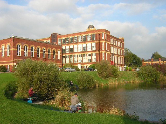
Two large red brick spinning mills, Coppull Mill in 1906, and Mavis Mill were built in the early 20th century. Coppull Mill has been converted for other uses and is a Grade II listed building.[11] The last surviving collieries were Chisnall Hall and Ellerbeck.[12]
Governance
[edit]Coppull was a township[13] in the ecclesiastical parish of St Wilfrid, Standish in the Hundred of Leyland.[14] It was a member of the Chorley Poor Law Union formed in 1837 that took responsibility for the administration and funding of the Poor Law.[15] Coppull became part of Chorley Rural Sanitary District from 1875 to 1894,[16] and part of Chorley Rural District from 1894 to 1974.[17] Since 1974, it is a civil parish and electoral ward in the Borough of Chorley.[18][19]
Economy
[edit]Since the decline in manufacturing and the end of the coal industry, the village has been converted into a satellite town for commuters to Chorley and Wigan. Notable industries today include The Yew Tree Dairy, Morris' Bakery and Staveley's egg producer.
Transport
[edit]Intersecting the village is the B5251 road, which connects Chorley to the Wigan-Preston Road. The village's closest motorway connections are the M6 Junction 27 at Standish and the M61 Junction 8 at Chorley.
Coppull is served by regular Bee Network services to Wigan (the 632) and Chorley Interchange and Stagecoach bus services to Chorley. Network Chorley service operated within the village until the early/mid 2010’s.
The village was previously served by the Blackpool to Liverpool Line which stopped at Coppull railway station but the station was closed in 1969. Recently there has been a campaign from locals to re-open the station.
Religion
[edit]There was a chapel in Coppull before the Reformation. After it fell into ruin, it was replaced in 1654 and was probably served from the parish church in Standish but was later used by Presbyterians. It was closed in 1715 and secured for the Church of England. A grant from Queen Anne's Bounty in 1716 led to the appointment of a perpetual curate. It was rebuilt in 1758 and again in 1861.[4][20]
The village has several places of worship,[21] Coppull Parish C of E Church, St John the Divine C of E Church,[22] St Oswald's Roman Catholic Church[23] and Spendmore Lane Methodist Church.[24]
Sport
[edit]Owing to Coppull's coal mining history and proximity to Wigan, the sport of rugby league has had a strong presence in the village. Chorley Panthers is a successful youth and amateur club based at Chisnall playing fields. Coppull is also home to Coppull United F.C, an amateur football team who currently play in the West Lancashire Premier Division.[25]
An amateur and professional boxing club is based at Coppull Mill.
Coppull also has a long tradition of Martial Arts with both Karate and Kung Fu clubs in the district. Red Sun Shotokan Karate Club has been based at St. John's Church Hall in Coppull since 1986 and was founded by P.A.J. Handyside, 9th Dan.[26]
Coppull is also home to Springfield Park Leisure Centre which holds classes for all age groups including freestyle, trampolining and indoor rock climbing.[27]
Notable people
[edit]- Amanda Roocroft (born 1966), opera singer
- John Barry Mason (1935–2021), songwriter known professionally as Barry Mason
See also
[edit]References
[edit]Notes
- ^ "Hic Bibi", Latin for "here drink I" was the name given to a well from which Oliver Cromwell was supposed to have drunk on a lane that now carries the name.[9]
Footnotes
- ^ "Build a custom area profile - Census 2021, ONS". www.ons.gov.uk. Retrieved 17 March 2024.
- ^ Roman Roads, Lancashire County Council, archived from the original on 8 February 2007, retrieved 26 September 2012
- ^ Mills 1998, p. 96
- ^ a b c d e William Farrer; J Brownbill, eds. (1911), "Coppull", A History of the County of Lancaster: Volume 6, Victoria County History, British History Online, pp. 224–229, retrieved 24 September 2012
- ^ Richard Arkwright - Biography, Lancashire County Council, archived from the original on 8 December 2012, retrieved 26 September 2010
- ^ Birkacre Colliery Co. Ltd, Durham Mining Museum, retrieved 26 September 2012
- ^ Yarrow Valley - a history, Chorley Council, archived from the original on 20 October 2007, retrieved 26 September 2010
- ^ Coppull, Lancashire. 20th. May, 1852. (PDF), cmhrc.co.uk, p. 23, archived from the original (PDF) on 13 June 2010, retrieved 26 September 2012
- ^ Welcome To Hic Bibi Local Nature Reserve, Chorley Council, retrieved 26 September 2010
- ^ North and East Lancashire's Mining Industry in 1896, projects.exeter.ac.uk, archived from the original on 13 August 2011, retrieved 26 September 2012
- ^ Historic England, "Coppul Ring Mill (1362173)", National Heritage List for England, retrieved 26 September 2012
- ^ North Western Division Map 89, cmhrc, archived from the original on 24 April 2010, retrieved 26 September 2010
- ^ Coppull Township Boundaries, GenUKI, retrieved 26 September 2010
- ^ Lewis, Samuel, ed. (1848), "Coppull", A Topographical Dictionary of England, British History Online, pp. 682–685, retrieved 26 September 2012
- ^ Workhouse, Workhouses.org, retrieved 26 September 2012
- ^ Great Britain Historical GIS Project. "Chorley RSD: Relationships and changes". A Vision of Britain through Time. University of Portsmouth. Retrieved 10 August 2016.
- ^ Great Britain Historical GIS Project. "Chorley RD: Relationships and changes". A Vision of Britain through Time. University of Portsmouth. Retrieved 10 August 2016.
- ^ Your Councillors by Ward. Chorley Council. Retrieved 27 June 2010.
- ^ Chorley Lower-Layer Super Output Areas Archived 10 March 2010 at the Wayback Machine. Lancashire County Council. Retrieved 27 June 2010.
- ^ Chapel Lane Church of England, Coppull, GenUKI, retrieved 26 September 2010
- ^ Coppull, GenUKI, retrieved 26 September 2010
- ^ St John the Divine, Coppull - Church of England, GenUKI, retrieved 26 September 2010
- ^ St Oswald, Coppull- Roman Catholic, GenUKI, retrieved 26 September 2010
- ^ Spendmore Lane Wesleyan Methodist, Coppull, GenUKI, retrieved 26 September 2010
- ^ "Coppull United F.C." coppullunitedfc.co.uk. Archived from the original on 19 August 2011. Retrieved 17 June 2013.
- ^ "Red Sun Shotokan Karate". redsunkarate.com. Retrieved 11 July 2013.
- ^ "Springfield Park Leisure".
Bibliography
- Mills, A.D. (1998), A Dictionary of English Placenames, Oxford University Press, ISBN 0-19-280074-4
External links
[edit]Coppull
View on GrokipediaHistory
Etymology and Early Settlement
The name Coppull derives from Old English elements, combining "copp," meaning a peak or hilltop, with "hyll," meaning hill, resulting in a pleonastic form interpreted as "copped hill" or "hill rising to a peak."[5][7] This etymology reflects the village's topography, situated on the 300-foot contour line and bounded by natural features such as the Clancutt Brook, River Yarrow, and various streams including Buckow Brook and Hic-Bibi Brook.[5] Historical records show early spellings like "Cophulle" and "Crophull" in the 13th century, "Cophull" in the 14th century, and the modern form "Coppull" by 1444, with the place first documented as "Cophill" around 1218.[5][8] Coppull's early settlement emerged as a rural township within the ancient Parish of Standish, initially forming part of Coppull-cum-Worthington in the 13th century.[5] The first mention of the Coppull family, probable lords of the manor and a branch of the Worthingtons, dates to 1215, with Richard, son of Thomas de Coppull, granting lands including Coppull Moor to Burscough Priory in 1236.[5] The manor remained with the Coppull family until 1461, when it passed to Thomas Stanley; by 1508, Edward Stanley, son of Thomas Stanley, Earl of Derby, held it, before it was sold to Alexander Rigby of Burgh around 1600, eventually transferring to the Livesey family by 1750 and John Hodgson of Ellerbeck by 1820.[5] Population growth was gradual, with the Subsidy Roll of 1542 recording 45 houses (estimating 225 residents), rising to 67 houses (about 335 people) by the 1670 Hearth Tax Returns, and 86 families (around 480 individuals) in a 1754 census.[5] A tradition suggests a church existed at Coppull as early as the 11th century, supported by a 1094 deed referencing "et ecclesium de Crophill."[5] Pre-industrial land use in Coppull centered on agriculture and small-scale monastic activities, with grants such as the 13th-century donation to Burscough Priory encompassing oxgangs of pannage in local woods for livestock management.[5] A circa 1240 deed from Richard de Charnock to William de Worthington included a house called Birkacre, lands along Culmariclough, rights to common pasture, wood for building and fencing, and access to a water mill, alongside allowances for specific livestock like 12 cows for five years and six mares for four years.[5] The presence of a "Grange" on Coppull Moor indicates a monastic farm tied to the priory, while tenants like the Haydocks paid annual rents of 3 shillings for estates such as Perburn before the Reformation, underscoring a mixed farming economy reliant on pasture, woodland resources, and limited milling.[5] Ecclesiastical ties linked Coppull closely to the Parish of Standish, where it served as a chapel of ease with a pre-Reformation chapel for Mass, as noted in a 1520 marriage covenant providing land for a priest.[5] The chapel offered sanctuary during Henry VIII's reign, with figures like Rowland Kirby seeking refuge there, though it fell into decay in the 16th century amid Commonwealth-era disputes.[5] Early connections extended to monastic institutions, including a 1094 grant of the church at "Crophill" to the Abbey of St Martin of Sées and land donations to Burscough Priory, with curates from Standish, such as Thomas Walkden in 1688, overseeing services until Coppull's later independence.[5]Industrial Revolution and Cotton Industry
The advent of the Industrial Revolution in Coppull was marked by the establishment of Birkacre Mill, a pioneering site for mechanized cotton spinning. In 1777, local landowner Edward Chadwick constructed the mill and leased it to Richard Arkwright, the inventor of the water frame, along with his partners including Jedediah Strutt and Samuel Need.[9][5] Arkwright equipped the facility with water-powered machinery, such as carding engines, roving engines, and spinning frames capable of producing 96 threads simultaneously, transforming the local textile production from cottage-based hand spinning to a factory system.[9] This operation employed over 400 workers, representing one of the earliest large-scale mechanized cotton mills in Lancashire and exemplifying Arkwright's vision of industrialized manufacturing powered by the River Yarrow.[5][10] However, the mill's innovative operations faced fierce opposition from displaced handloom weavers amid a trade slump. On October 4, 1779, a mob of approximately 2,000 to 4,000 rioters attacked and destroyed the mill, burning its wooden structures and machinery in a significant act of Luddite-style resistance that resulted in three deaths.[9][5] The damage was estimated at £10,000, though parliamentary records valued it at £4,400, leading Arkwright to surrender his lease and shift focus to his Derbyshire operations.[5] Chadwick subsequently rebuilt the mill in 1781 for cloth dyeing and finishing, leasing it to new partners, but this venture failed by 1782 and evolved into various non-spinning textile processes over the decades, with no return to cotton spinning in Coppull for over a century.[5][9] Cotton spinning revived in Coppull during the early 20th century with the construction of large-scale mills that reflected advancements in ring spinning technology. The Coppull Ring Spinning Mill, built in 1906, was designed to house 60,000 ring spindles supplied by Platt Bros, marking a substantial investment in modern textile infrastructure.[11][5] Nearby, Mavis Mill followed in 1908, both structures featuring red brick construction and contributing to the village's architectural heritage; the Ring Mill is now a Grade II listed building recognized for its special historic interest.[6][5] These mills spurred economic growth by creating jobs for mill workers and attracting a population influx, with Coppull's residents increasing from 484 in 1764 to 1,107 by 1851, driven in part by early textile opportunities that shaped local infrastructure like housing. The integration of rail transport, including the nearby main line that divided the parish by 1912, facilitated the distribution of cotton goods, enhancing the mills' economic viability alongside broader industrial synergies.[5]Coal Mining Era
Coppull's integration into the Wigan–Chorley coalfield marked a pivotal expansion of coal mining in the region during the 19th century, with the village serving as a key node in Lancashire's industrial landscape. Mining activities, which had roots in earlier centuries, intensified post-1800 as the coalfield's seams, particularly the Arley and related layers, drew investment for deep extraction. This development positioned Coppull within a broader network of pits that fueled the Industrial Revolution, complementing local textile operations by providing essential coal for powering mills.[5][12] Several collieries were established or expanded in Coppull after 1800, including John Pit, Springfield Pit, Blainscough Colliery (opened 1865), Hic-Bibi, Darlingtons, Ellerbeck, Birkacre, and Pearson & Knowles (later Chisnall Hall Colliery, opened 1891). These pits were strategically located in valleys such as Birkacre and Whetstone, as well as near Coppull Hall and west of the River Yarrow, facilitating access to the coalfield's resources. Output reached peaks toward the late 19th century, with the Wigan Coalfield—encompassing Coppull—achieving near-maximum production by the 1890s, exemplified by Chisnall Hall's growing workforce from 159 employees in 1894 to 402 by 1900, reflecting heightened extraction of gas, household, and manufacturing coal.[5][13][12] Mining techniques in Coppull evolved from early surface and shallow methods to deep shaft sinking between 1850 and 1892, employing steam-powered pumps, horse-drawn whim gins, and locomotives like Timothy Hackworth's Sans Pareil at Coppull Hall Colliery from 1849 for hauling and pumping. Safety issues were prevalent due to the gassy nature of seams like the Arley, with hazards including firedamp accumulation, roof falls, and inadequate ventilation, often exacerbated by rudimentary stoppings made of coal and rubbish that retained air in single columns. These challenges underscored the perilous conditions, prompting gradual introductions of safety lamps and mechanized ventilation, though enforcement remained inconsistent.[5][13] The coal mining boom profoundly shaped Coppull's social fabric, driving population growth from 1,107 in 1851 to 2,940 by 1901 through influxes of workers and families, reaching over 5,000 by 1951. This led to the construction of miners' terraces and community facilities, such as the 1874 school at Coppull Moor funded by local industrialists James Darlington and Alfred Hewlett, and the 1888-founded Coppull Band, whose room served as a welfare hub for social gatherings and services. Employment in the pits fostered tight-knit colonies, with hundreds reliant on mining for livelihood, though the industry's dangers imposed ongoing strains on community health and stability.[5][12][14]20th Century Developments and Industrial Decline
In the early 20th century, Coppull saw the establishment of new textile mills that briefly expanded the local cotton industry. Coppull Ring Mill, also known as Coppull Mill, was built in 1906, followed by Mavis Mill in 1908; both were steam-powered spinning mills that employed hundreds of local workers during their operational peak.[5][15] These mills were acquired by the Lancashire Cotton Corporation in the early 1940s as part of broader industry consolidation efforts amid economic pressures.[15] However, the textile sector in Coppull experienced gradual decline due to national economic shifts, including competition from abroad and post-war restructuring. Birkacre Mills, involved in calico printing and bleaching, closed during the 1930s depression and were repurposed for storage by the Ministry of Supply and other firms, with the buildings demolished in the 1960s.[5] Mavis Mill ceased operations and was demolished by the mid-20th century, while Coppull Ring Mill was later converted to non-textile uses, reflecting the broader contraction of Lancashire's cotton industry.[15] These closures contributed to job losses in a sector that had been central to the village's economy. Coal mining, another pillar of Coppull's industry, also faced progressive closures from the mid-20th century, exacerbating employment challenges. Ellerbeck Colliery, operational since 1876 and nationalized in 1947, employed hundreds until its closure in 1965.[15] Chisnall Hall Colliery, the last major pit in the area, shut down in March 1967, marking the end of deep coal mining in the Wigan-Chorley coalfield and leading to significant unemployment among miners who had dominated the local workforce.[16] The impact was profound, as coal had been a dominant employer, with community responses including a commemorative service at St John the Divine Church to honor the industry's legacy and the workers affected.[5] As industries declined, Coppull began transitioning toward a commuter community, with infrastructure adaptations facilitating easier access to jobs elsewhere. Existing rail connections, including the main line and mineral railways from former collieries, supported this shift by improving links to nearby urban centers like Chorley and Wigan, though without major new developments in housing.[5][15] Early diversification attempts were limited, often involving repurposing industrial sites for storage or other non-manufacturing purposes, as the village adapted to reduced local employment opportunities.[5]Geography
Location and Topography
Coppull is a village and civil parish located in the Borough of Chorley, within the county of Lancashire, England. It lies approximately 5 miles (8 km) west of Chorley town centre and 7 miles (11 km) south of Wigan, positioned along the eastern side of the A49 road near Charnock Richard. The civil parish encompasses a defined area with boundaries that include surrounding rural lands, as mapped by Ordnance Survey references centred on grid SD564137. Its central geographic coordinates are approximately 53°37′15″N 2°39′39″W.[17][18][19][2][3] The topography of Coppull features a hilltop setting at an elevation of around 300 feet (91 m) above sea level. This undulating terrain is part of the broader Wigan-Chorley coalfield landscape, characterized by gentle rises and valleys that historically influenced settlement patterns. The village's proximity to the River Yarrow and its associated valley provided essential water resources for early mechanized cotton spinning mills, such as the 18th-century Birkacre Mill, and supported coal mining activities by facilitating drainage and transport in the surrounding low-lying areas.[20][9][21] Amid its industrial heritage, Coppull has preserved significant natural landscapes, including green spaces and conservation areas that mitigate urban expansion. The Yarrow Valley Country Park, encompassing wooded river corridors and open countryside along the River Yarrow, serves as a key recreational and ecological area bordering the village. Additionally, Hic Bibi Nature Reserve within the parish supports biodiversity conservation and public access to natural habitats, contributing to the maintenance of the area's rural character despite historical development pressures.[22][23]Housing and Urban Layout
The housing in Coppull evolved significantly from the 19th century onward, reflecting the village's industrial heritage in coal mining and cotton textiles, with terraced homes initially built to support the workforce before transitioning to modern estates in response to economic decline and population growth, thereby preserving visible patterns of industrial-era transformation while adapting to commuter needs.[5] In the 19th century, miners' and mill workers' terraces were developed to house the growing industrial population, often clustering directly around collieries and mills for convenient access to employment. Specific examples include the cottages near Coppull Hall Colliery, where workers lived in close proximity to the pits, as evidenced by the tragic 1852 explosion that affected the local mining community; similar terraces emerged around sites like Blainscough and Chisnall Hall Collieries, as well as early textile mills in the Birkacre Valley, which employed over 400 people and spurred residential clusters along the brooks and valleys supporting these operations.[5] These back-to-back or linear terraced houses, such as those on Preston Road associated with hand loom weavers, were typically modest and densely packed, mirroring broader patterns in Lancashire's coalfield villages to accommodate the influx of laborers drawn to the Wigan-Chorley mining district.[5] This clustering established a layout tied to industrial sites, with housing radiating from pits and mills, shaping the village's compact core amid rural surroundings. The 20th century saw population growth following the decline of local industries, particularly after the closure of the last colliery at Chisnall Hall in 1967, with the population increasing from 5,657 in 1951 to 7,184 by 1971.[5] In recent decades, modern estates have further expanded Coppull, including developments like Elmbrook Park, which offers 3- to 5-bedroom homes with 30% affordable units, and Church View, featuring semi-detached and detached properties designed for family living, both approved by Chorley Council to integrate with existing infrastructure while promoting sustainable growth.[24][25][26] Additionally, sites like the former miners' cottages area off Preston Road have been proposed for 39 affordable homes as of November 2023, emphasizing the village's ongoing adaptation to housing needs post-industrial era.[27] These developments extend the original industrial housing patterns into commuter-oriented expansions, maintaining linear growth without erasing the historical footprint of mining and milling communities. Coppull's overall urban layout has been shaped by linear development along key transport routes, such as Preston Road—a historic turnpike—and the railway line, which divided the parish in 1912 and encouraged ribbon-like expansion of housing from historic terraces to contemporary estates. This pattern preserves industrial-era clustering while accommodating its role as a commuter community, with residential areas extending westward and northward from the core village center bounded by natural brooks, ensuring connectivity to nearby towns like Chorley and Wigan without disrupting the 300-foot contour topography.[5]Demographics
Population Trends
In the 19th century, Coppull experienced significant population growth driven by the expansion of its cotton spinning and coal mining industries, transforming it from a small rural settlement into a burgeoning industrial community. Local records indicate that the population was estimated at 876 in 1832, reflecting a modest base prior to widespread mechanization. By 1851, this had increased to 1,107, coinciding with peaks in textile production at mills like Birkacre and the opening of numerous collieries in the Wigan-Chorley coalfield. Further growth occurred as mining and cotton booms attracted workers, with the population reaching 2,940 by 1901.[5][14] The 20th century saw continued fluctuations in Coppull's population, influenced by the rise and eventual decline of heavy industries, alongside shifts toward lighter manufacturing and residential development. From 5,657 residents in 1951, the population rose to 7,184 by 1971, supported by post-war economic recovery and infrastructure improvements such as rail links that facilitated worker mobility. However, the closure of key collieries in the mid-20th century led to some economic pressures, though overall numbers stabilized rather than sharply declined, with migration patterns reflecting both outbound movement from redundant mining jobs and inbound from nearby urban centers like Chorley and Wigan. By the late 20th century, this stabilization marked Coppull's transition from industrial dependence to a more balanced community structure.[5] Recent census data highlights a steady increase, underscoring Coppull's adaptation to post-industrial patterns with growth to 7,959 in 2011 and 8,304 in 2021, aligning with broader trends of suburban expansion in Lancashire. These figures represent a stabilization around 8,000, with modest annual changes of approximately 0.43% between 2011 and 2021, driven by housing developments and proximity to larger employment hubs.[28][29]| Year | Population |
|---|---|
| 1832 | 876 |
| 1851 | 1,107 |
| 1901 | 2,940 |
| 1951 | 5,657 |
| 1971 | 7,184 |
| 2011 | 7,959 |
| 2021 | 8,304 |
