Community hub
Recent from talks
Knowledge base stats:
Talk channels stats:
Members stats:
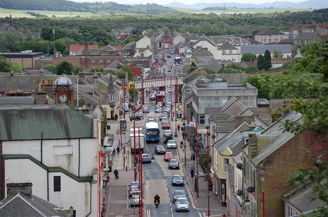
Cowdenbeath
Cowdenbeath (/ˌkaʊdənˈbiːθ/ ⓘ) is a town and burgh in west Fife, Scotland. It is 5 miles (8 km) north-east of Dunfermline and 18 miles (29 km) north of the capital, Edinburgh. The town grew up around the extensive coalfields of the area and became a police burgh in 1890. According to a 2008 estimate, the town has a population of 14,081.
The wider civil parish of Beath has a population of 17,351 (in 2011).
The first element of the town's name comes from the surname Colden or Cowden, often indicated in early forms as a possessor by the addition of -(i)s, for example Cowdennyes Baith. Beath, the name of the wider parish, is from the Gaelic beith, meaning birch.
The earliest indication of human activity in the immediate vicinity of the current site of Cowdenbeath was provided by the discovery of late Bronze Age vessels containing incinerated human remains, in 1928. An article by eminent archaeologist A.D. Lacaille F.S.A Scot details the find of a late bronze-age cemetery near Tollie Hill. One of the urns found contained fragments of processed Arran pitchstone, indicating some economic activity and commerce.
There is no evidence of a permanent settlement establishing itself around the current site of Cowdenbeath until the designation of the original Beath Kirk as a parish church in 1429–1430 to act as a focal point to serve the surrounding area. The earliest written record of Beath (Beth) was found in a charter of Inchcolm Abbey, dated 6 March 1178. This charter makes reference to the Chapel of Beth. Although it is generally accepted that the word beath in Gaelic means "birch", P.W. Brown suggests that the word means "abode" or "a settlement". In 1643 the Reverend John Row of Carnock, a leading opponent of episcopacy, was instrumental in establishing the Parish of Beath as an entity in its own right by separating it from the parish of Dalgety Bay and Aberdour. This significant date followed the building of a new church in 1640 at Beath, to replace the ruins of a sanctuary, which had fallen into sad disrepair. The present church, visible today, was constructed in 1834–35 by James MacFarlane and was altered in 1884–1886.
It is alleged that the infamous graverobbers Burke and Hare sourced some of their cadavers from Beath Cemetery, to supply to the Scottish surgeon Robert Knox for dissection. Precautions were taken at Beath Cemetery to prevent body-snatching and for many years what were taken to be two iron coffins without lids dug up from the old churchyard lay near the old hearse house. These were not actually coffins, but old-time safes that were placed over the coffin to hinder the work of the body-snatchers. Another preventative measure adopted was the placing of a large flat stone on top of the grave. This stone was very heavy and was placed on the grave and removed by means of a trestle hoist, the rope going through the stone and fastened on the underside, and it remained there until the danger of "snatching" was past. The two "safes" have since disappeared, but the flat stone is still to be seen near the church. The Blaeu Atlas of Scotland, published in 1654 by eminent 17th-century Dutch cartographer Joan Blaeu, refers to Cowden Beth in the current vicinity of Cowdenbeath.
When the actual name of Cowdenbeath came into being is not known. In 1626, the area belonged to Willielmus Walker, a citizen of Dunfermline who owned the territory of BaitheMoubray alias Cowdounes - baithe meaning Cowdens part of Beath, where Beath meant Birch Trees. However, it is thought to have originated when turnpike roads were first made and that it marked the spot of an inn and later of a tollhouse erected in the 17th century.
By 1790 the records show that the parish of Beath had about 100 families whose livelihood came mainly from the soil. The fact that Beath Church served a very large area led to the creation of many "kirke roads", roads that form rights-of-way even today. This church was replaced by the present church, built in 1832 and enlarged in 1886.
Hub AI
Cowdenbeath AI simulator
(@Cowdenbeath_simulator)
Cowdenbeath
Cowdenbeath (/ˌkaʊdənˈbiːθ/ ⓘ) is a town and burgh in west Fife, Scotland. It is 5 miles (8 km) north-east of Dunfermline and 18 miles (29 km) north of the capital, Edinburgh. The town grew up around the extensive coalfields of the area and became a police burgh in 1890. According to a 2008 estimate, the town has a population of 14,081.
The wider civil parish of Beath has a population of 17,351 (in 2011).
The first element of the town's name comes from the surname Colden or Cowden, often indicated in early forms as a possessor by the addition of -(i)s, for example Cowdennyes Baith. Beath, the name of the wider parish, is from the Gaelic beith, meaning birch.
The earliest indication of human activity in the immediate vicinity of the current site of Cowdenbeath was provided by the discovery of late Bronze Age vessels containing incinerated human remains, in 1928. An article by eminent archaeologist A.D. Lacaille F.S.A Scot details the find of a late bronze-age cemetery near Tollie Hill. One of the urns found contained fragments of processed Arran pitchstone, indicating some economic activity and commerce.
There is no evidence of a permanent settlement establishing itself around the current site of Cowdenbeath until the designation of the original Beath Kirk as a parish church in 1429–1430 to act as a focal point to serve the surrounding area. The earliest written record of Beath (Beth) was found in a charter of Inchcolm Abbey, dated 6 March 1178. This charter makes reference to the Chapel of Beth. Although it is generally accepted that the word beath in Gaelic means "birch", P.W. Brown suggests that the word means "abode" or "a settlement". In 1643 the Reverend John Row of Carnock, a leading opponent of episcopacy, was instrumental in establishing the Parish of Beath as an entity in its own right by separating it from the parish of Dalgety Bay and Aberdour. This significant date followed the building of a new church in 1640 at Beath, to replace the ruins of a sanctuary, which had fallen into sad disrepair. The present church, visible today, was constructed in 1834–35 by James MacFarlane and was altered in 1884–1886.
It is alleged that the infamous graverobbers Burke and Hare sourced some of their cadavers from Beath Cemetery, to supply to the Scottish surgeon Robert Knox for dissection. Precautions were taken at Beath Cemetery to prevent body-snatching and for many years what were taken to be two iron coffins without lids dug up from the old churchyard lay near the old hearse house. These were not actually coffins, but old-time safes that were placed over the coffin to hinder the work of the body-snatchers. Another preventative measure adopted was the placing of a large flat stone on top of the grave. This stone was very heavy and was placed on the grave and removed by means of a trestle hoist, the rope going through the stone and fastened on the underside, and it remained there until the danger of "snatching" was past. The two "safes" have since disappeared, but the flat stone is still to be seen near the church. The Blaeu Atlas of Scotland, published in 1654 by eminent 17th-century Dutch cartographer Joan Blaeu, refers to Cowden Beth in the current vicinity of Cowdenbeath.
When the actual name of Cowdenbeath came into being is not known. In 1626, the area belonged to Willielmus Walker, a citizen of Dunfermline who owned the territory of BaitheMoubray alias Cowdounes - baithe meaning Cowdens part of Beath, where Beath meant Birch Trees. However, it is thought to have originated when turnpike roads were first made and that it marked the spot of an inn and later of a tollhouse erected in the 17th century.
By 1790 the records show that the parish of Beath had about 100 families whose livelihood came mainly from the soil. The fact that Beath Church served a very large area led to the creation of many "kirke roads", roads that form rights-of-way even today. This church was replaced by the present church, built in 1832 and enlarged in 1886.