
Community hub
Recent from talks
Contribute something
Nothing was collected or created yet.
Craster
View on Wikipedia
Craster is a small fishing village on the Northumberland coast of England, eight miles (13 km) from Alnwick. The next village to the north is Embleton. It is within the Northumberland Coast Area of Outstanding Natural Beauty.
Key Information


Geography
[edit]The walk along the coast to the south passes by Cullernose Point, an example of the basaltic cliffs which are a significant feature of the local landscape, and are part of the Whin Sill. The walk along the rocky shore to the north along leads to the ruins of Dunstanburgh Castle.[2]
History
[edit]The remains of a tower on the end of the harbour are all that can be seen now of the much taller building which was part of the overhead equipment which used to convey the local stone from where it was quarried to boats in the harbour. The disused quarry is now a car park.[3]
A mile to the west, Dunstan Hall is a mansion incorporating a medieval pele tower, now used as holiday accommodation.[4]
A small distance inland lies Craster Tower, the home of the Craster family who were the local lords of the manor.[5] A memorial on the harbour wall commemorates Captain John Charles Pulleine Craster, who was killed in Tibet on 28 June 1904.[6][7]
For many years, the village has had a herring-curing business:[3] Craster kippers are well known around the world.[8]
During the Second World War, the Heughs, north of Craster, were home to a Coastal Defence/Chain Home radar station.[9]
References
[edit]- ^ "Parish population 2011". Archived from the original on 5 July 2015. Retrieved 29 June 2015.
- ^ "Craster to Dunstanburgh Castle Walk". Third Eye Traveller. May 2020. Retrieved 16 October 2023.
- ^ a b "Craster History We Can Mind the Time". visitcraster.org.uk.
- ^ Historic England. "Dunstan Hall (1041815)". National Heritage List for England. Retrieved 16 October 2023.
- ^ "CLHG History Walks Craster Tower". www.crasterhistory.org.uk. Retrieved 26 June 2020.
- ^ "Memorial to Captain Craster". Craster Local History Group. Retrieved 16 October 2023.
- ^ Memorial to John Charles Pullein Craster Archived 23 February 2012 at the Wayback Machine
- ^ "Where to Eat the Best Kippers in the World? | TasteAtlas". www.tasteatlas.com. Retrieved 7 June 2022.
- ^ Brown, Mark (15 December 2023). "Boat-shaped church and radar station among English heritage list newcomers". The Guardian. Retrieved 13 December 2023.
External links
[edit]- Northumberland Communities (Accessed: 6 November 2008)
- Craster History told by the people themselves
Craster
View on GrokipediaGeography
Location
Craster is a small coastal village in Northumberland, England, situated on the North Sea coast approximately 6 miles (9.7 km) northeast of Alnwick and 50 miles (80 km) north of Newcastle upon Tyne.[1][8] It lies within the civil parish of Embleton and is positioned at coordinates 55°28′17″N 1°35′34″W, corresponding to Ordnance Survey grid reference NU221197.[1] The village is bordered to the north by Embleton Bay and to the south by the rocky headland leading toward Howick, with Dunstanburgh Castle visible along the shoreline to the north.[3] Craster forms part of the Northumberland Coast Area of Outstanding Natural Beauty, encompassing dramatic coastal scenery, dunes, and wildlife habitats that extend along much of the region's shoreline.[3]Physical Features
Craster occupies a narrow strip of the North Northumberland Coastal Plain, characterized by its exposure to the North Sea along a dramatic, rocky shoreline. The village lies at the base of steep cliffs formed primarily from the Whin Sill, a layer of hard dolerite intruded into the Carboniferous bedrock approximately 295 million years ago. These cliffs, rising sharply from the sea, exemplify the region's igneous geology and contribute to the area's rugged coastal profile.[9] A key physical landmark is Cullernose Point, located about 1 km south of the village center, where the dolerite forms a prominent headland with well-developed columnar jointing—hexagonal pillars created during the rock's cooling process. This point juts into the sea, creating sheltered bays to the south lined with folded limestones and sandstones, while the overlying cliffs support diverse seabird colonies, including fulmars and gannets. North of Craster, the coastline transitions to a grassy, pebbly shore extending toward the elevated ruins of Dunstanburgh Castle, perched on similar dolerite outcrops up to 50 meters high.[9][10] The village's small harbor, built in 1906, is a man-made feature nestled against these natural cliffs, providing a sheltered inlet amid otherwise exposed rocky reefs and limestone outcrops that extend offshore. These reefs, including two wedge-shaped limestone islands near the harbor, influence local tidal patterns and create a varied intertidal zone. Inland, the terrain gently rises to low-lying farmland typical of the coastal plain, with whinstone quarries—such as the historic Craster Quarry—exposing the underlying basalt layers that were once extracted for construction.[11][12][5]History
Origins and Early Settlement
The area now known as Craster has evidence of human occupation dating back to the Iron Age, with a defended settlement located on Craster Heugh, a whinstone ridge overlooking the coast. This site, a Scheduled Monument, features an enclosure utilizing natural cliffs for protection on the north and west sides, supplemented by raised banking and ditches on the other approaches, typical of Iron Age defensive structures in Northumberland.[13] The monument's design suggests it served as a promontory fort, providing strategic oversight of the coastal landscape.[14] The name "Craster" derives from the Old English "Crawcestre" or "Craucestre," meaning "crow's earthwork" or "crow's camp," likely referring to this Iron Age fortification on Craster Heugh, about one-third of a mile southwest of the modern village.[15] Prior to the Norman Conquest in 1066, Craster formed one of nine townships within the larger parish of Embleton, indicating early medieval agrarian settlement patterns in the region, though specific details on pre-Conquest inhabitants remain sparse.[15] Following the Conquest, the land was integrated into the barony of Embleton and the Vescy lordship of Alnwick, with feudal tenures emerging by the mid-12th century.[15] The Craster family's association with the area began in the 12th century, when Albert de Crawcestre, possibly originating from the Rhineland or Yorkshire's Cleveland district, acquired the estate through marriage to Christiana of Redcar and adopted the locational surname.[16][17] By 1166, Albert held Craster as a knight's fee under the feudal system, and his son William de Craucestre is recorded as the estate holder in 1272.[18] Albert is believed to have constructed an early hall at Crawcestre, marking the establishment of a manorial center that anchored the township's medieval settlement.[16] The medieval village developed on a hill near this hall, now the site of Craster Tower, rather than the coastal location of the present village, which originated in the late 18th century.[19] In the late 14th century, amid border conflicts with Scotland, Sir Edmund Craster built a pele tower at the site—first documented in 1415 as one of Northumberland's border strongholds—to fortify the property against raids.[16] This structure, later expanded in the 17th and 18th centuries, symbolized the family's enduring tenure and the township's role in regional defense and agriculture during the medieval period.[15]19th and 20th Centuries
During the 19th century, Craster evolved from a modest coastal settlement into a thriving fishing village, with its population peaking at around 250 in the 1850s, driven primarily by the herring industry and local quarrying.[20] The village's economy centered on curing herring into kippers, earning it an international reputation; by the mid-century, four smokehouses operated at its height, including the Grade II-listed Robson's Smokehouse (listed in 2023), constructed in 1856 as a key facility for processing fish for domestic and European markets.[21][22] In 1887, four fish curers were active in Craster, among them William Archbold, who employed James Robson in the trade.[21] The Craster family, long-time landowners, played a pivotal role in the village's development, funding infrastructure such as the St. Peter the Fisherman church in 1876 and supporting community buildings like Craster Square.[20] The early 20th century marked a period of modernization and subsequent decline in traditional industries, beginning with the construction of the current stone harbor between 1906 and 1912 by the Craster family in memory of Captain John Charles Pulleine Craster, who died in action in Tibet in 1904.[20] This facility facilitated peak imports and exports around 1910, supporting fishing and quarrying, but both sectors waned thereafter due to competition from railways and refrigeration, which made fresh fish like cod and plaice more accessible and affordable.[20] Quarries closed in the 1930s, and the herring industry collapsed in the 1920s and 1930s, leading to bankruptcies and the abandonment of smokehouses; by 1947, only two of the original four remained operational.[21][20] World War II further impacted the community, with residents contributing to the war effort through service or local support.[18] Post-war recovery saw a gradual shift toward tourism, though fishing persisted through family-run operations like L. Robson & Sons, which James Robson acquired in 1906 and has continued across four generations as Craster's sole surviving smokehouse, specializing in traditional kippers.[21] Urban changes included the demolition of Craster Square in 1962 to make way for new housing, while former quarry sites were repurposed as car parks to accommodate visitors drawn to the area's natural beauty and proximity to Dunstanburgh Castle.[20] By the late 20th century, the village's population stabilized at 100-200, with tourism supplementing the diminished fishing economy.[18]Economy and Society
Fishing and Smoking Industry
Craster's economy has long been anchored in its fishing industry, particularly the exploitation of North Sea herring shoals that drew seasonal fleets to the Northumberland coast in the 19th century. The village, originally known as Craster Seahouses, transitioned from agriculture to a sea-focused livelihood in the 1830s under the influence of landowner Shafto Craster, who promoted herring curing as a key economic activity.[23] By the mid-19th century, herring fishing peaked during September drifts, with local cobles and visiting Scottish driftnet vessels landing vast quantities for processing, supporting a workforce that included "herring girls" who gutted, salted, and packed the fish into barrels for domestic and European export.[24] This industry transformed Craster into a bustling hub, with up to four fish curers operating by 1887 and quantities of herring reaching over 3,000 fresh and 2,000 cured barrels documented in late-19th-century records.[5] The development of Craster Harbour, constructed by the Craster family in the decade before World War I (circa 1904–1914), was pivotal in sustaining the fishing trade. Dedicated to Captain John Charles Pulleine Craster, the harbor's piers and breakwaters provided safe anchorage for cobles and larger vessels, facilitating the landing of herring alongside whitefish, crabs, and lobsters.[5] Prior to this, fishermen beached their boats on the foreshore between local carr rocks, limiting operations to calm weather. The harbor's infrastructure, including storage rooms, enabled efficient curing and supported an estimated annual income of around £100 from fisheries dues by 1897, underscoring its role in scaling up the local economy.[5] Integral to the fishing sector is Craster's renowned smoking industry, centered on producing kippers—split, salted, and cold-smoked herring. Established in 1856 with the construction of a dedicated smokehouse, the practice originated from local innovator Jack Mason in the late 19th century and quickly became the village's signature product.[25] L. Robson & Sons, the sole remaining curer since acquiring the smokehouse in 1906 and now in its fourth generation under Neil Robson, preserves these traditional methods: herring are opened, brined in salt, hung on tenterhooks, and smoked for 16 hours over fires fueled by whitewood shavings and oak sawdust, imparting the characteristic flavor and golden hue.[21] This Grade II-listed facility, recognized in 2023 for its historical significance, exemplifies the North East's herring yards that proliferated from the mid-1800s to provide affordable protein.[26] At its height, the industry supplied markets across Britain and Europe, but declined in the 1920s–1930s as rail transport and refrigeration favored fresh fish like cod over preserved herring.[21] The herring fishery faced further setbacks from overfishing in the 1970s, leading to stock collapses and regulatory quotas under bodies like the Herring Industry Board, established in 1935 to bolster the trade. Today, Craster's fishing remains small-scale, with local boats targeting crabs, lobsters, and whitefish, while kippers are produced using sustainably sourced Norwegian herring to meet demand. L. Robson & Sons continues operations year-round, blending tradition with modern sustainability, though the industry now supports fewer than a dozen full-time fishers and relies partly on tourism for viability.[26] This enduring legacy highlights Craster's adaptation from a herring boomtown to a niche producer of heritage seafood.[21]Tourism and Modern Economy
Tourism has become a cornerstone of Craster's modern economy, complementing its traditional fishing and kipper-smoking heritage. The village attracts visitors drawn to its rugged coastal scenery, historic landmarks, and authentic Northumbrian experiences, contributing significantly to local employment and business sustainability. Alongside the renowned oak-smoked kippers produced by L. Robson & Sons since 1856, tourism supports a range of accommodations, eateries, and artisan shops, fostering year-round economic activity in this small coastal community.[11][3][27] Key attractions include Craster Harbour, a picturesque early 20th-century stone structure where fishing boats still operate, offering views toward the dramatic ruins of Dunstanburgh Castle, a 14th-century fortress accessible via scenic coastal paths. Visitors frequently engage in walking the Northumberland Coast Path, with routes extending north to the castle or south to Howick, passing hidden coves like Rumbling Kern, historically associated with smuggling. The Arnold Memorial Nature Reserve provides opportunities for birdwatching, spotting species such as wrynecks and red-breasted flycatchers, while the Mick Oxley Gallery showcases local seaside-inspired art and crafts. These sites, combined with the village's tranquil atmosphere, appeal to hikers, history enthusiasts, and families seeking outdoor pursuits.[3][11] The kipper smokehouse itself serves as a culinary draw, with tours and tastings highlighting traditional methods in Grade II-listed buildings, enhancing Craster's reputation for gourmet tourism. Economically, this visitor influx has spurred growth in hospitality, with establishments like The Ship Inn providing locally sourced meals and overnight stays. In the broader Northumberland context, tourism generated a record £1.443 billion for the county in 2024, underscoring the sector's vitality and its role in sustaining rural economies like Craster's through sustainable practices that preserve the area's natural and cultural assets.[3][27][28]Landmarks
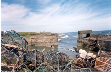
Craster Harbour
Craster Harbour is a small, picturesque fishing harbour located on the Northumberland coast in England, serving as a key landmark of the village. Constructed in 1906 by the Craster family, it was built as a memorial to Captain John Charles Pulleine Craster, who died during the British expedition to Tibet in June 1904. Prior to its development, local fishermen had relied on the natural protection offered by the offshore rocks at Craster Haven for centuries, landing catches of herring and other fish along the foreshore.[29][5] The harbour's construction addressed the need for a more secure facility to support the local fishing industry and facilitate the transport of stone from nearby whinstone quarries, which provided much of the building material for the structure itself. Funded entirely by the Craster family, who owned Craster Tower, the harbour included two piers: the North Pier, completed first in 1906 and bearing a commemorative plaque for Captain Craster, and the South Pier, added subsequently. An aerial ropeway system once extended from a quarry to the west—now the village car park—to load stone onto ships, with remnants visible at the end of the South Pier. A concrete frame on the South Pier wall was designed to frame views of Dunstanburgh Castle, enhancing the site's scenic appeal.[29][5][11] Historically, the harbour boosted local commerce by enabling the landing of herring (both fresh and cured, totaling over 5,000 barrels annually in early records), crabs, lobsters, and other seafood, alongside imports like salt for curing. By 1908, it was governed by bye-laws outlined in a pamphlet authored by T.W. Craster, regulating charges and operations to ensure efficient use. The facility projected modest annual income from dues and activities, supporting the village's economy amid the herring boom.[5][30] In the modern era, Craster Harbour remains a working port, though the scale of fishing has diminished with the decline of whitefish stocks. It now primarily supports potting for lobsters and crabs, sustaining a small fleet of vessels, while the renowned kipper-smoking industry—using traditional oak smoke—continues to draw visitors and supply markets, including royal preferences. Tourism has become integral, with the harbour attracting walkers along the Northumberland Coast Path, birdwatchers, and sightseers for its dramatic views. It has also served as a location for recent television productions, such as the 2024 series The Red King.[11][3][29][31]Craster Tower
Craster Tower is a Grade II* listed country house located approximately half a mile west of the village of Craster in Northumberland, England, incorporating a medieval pele tower that served as a defensive structure during the Border Reivers period.[32] The tower, originally constructed in the mid-14th century, was built by the Craster family, who have owned the estate since the mid-12th century when Albert de Crawcestre acquired lands in the area.[33] Over centuries, the structure evolved from a fortified tower house into a Georgian mansion, reflecting the family's enduring presence and adaptations to changing architectural tastes.[34] The pele tower itself is a rectangular, four-storey stone structure—later reduced to three storeys—with thick walls, a barrel-vaulted basement, and a spiral staircase in the southeast corner, designed for defense against raids in the Anglo-Scottish border region.[34] By the late 17th century, around 1666–1675, Edmund Craster enlarged the tower by adding an east wing, transforming it into a manor house.[33] Further modifications occurred in 1769 when George Craster commissioned a Palladian-style south wing, possibly designed by architect William Newton, featuring three storeys with Tuscan doorways, pedimented windows, and 12-pane sash windows in whinstone with sandstone ashlar dressings.[32] In 1785, Shafto Craster Gothicized the tower by adding chamfered plinths, tripartite Gothic windows, and an embattled parapet, blending medieval and neoclassical elements.[33] The 19th century brought additional changes, including modernization in 1837–1838 by architect John Dobson, who added an extra storey and widened the east wing, along with a rendered extension on the east side with slate roofs.[34] The property remained in Craster family hands, passing through branches including Thomas Wood-Craster in 1838, who adopted the hyphenated surname by royal licence.[33] In 1965, following inheritance by cousins, the tower was divided into three private dwellings to preserve it, a configuration that persists today under family ownership.[33] One medieval window from the original tower survives, underscoring its historical continuity.[34] As a protected heritage site, Craster Tower holds special architectural and historic interest for its layered construction, exemplifying the transition from medieval fortification to Georgian domestic architecture in Northumberland.[32] Its listing under the Planning (Listed Buildings and Conservation Areas) Act 1990 ensures preservation, highlighting the Craster family's 850-year stewardship of the site.[33]Community and Culture
Demographics
Craster is a small civil parish in Northumberland, England, with a population of 268 as recorded in the 2021 Census.[35] This represents a decline of 1.3% annually from the 305 residents counted in the 2011 Census, continuing a trend of gradual depopulation observed since the 2001 Census figure of 342.[35][36] The parish covers an area of 9.709 km², resulting in a low population density of 27.60 inhabitants per km².[35] The population is characterized by an aging demographic structure, with 38.1% of residents aged 65 or older in 2021, compared to 34.8% in 2011. Children and young people under 18 make up 14.6% of the population, while working-age adults (18–64) constitute 48.1%. This shift reflects broader rural trends in Northumberland, where older age groups predominate. The following table summarizes the 2021 age distribution (note: detailed figures for small parishes may be subject to ONS rounding and suppression for privacy; numbers are approximate and sum to 270 due to methodological aggregation):| Age Group | Number | Percentage |
|---|---|---|
| 0–9 years | 15 | 5.6% |
| 10–19 years | 26 | 9.7% |
| 20–29 years | 14 | 5.2% |
| 30–39 years | 12 | 4.5% |
| 40–49 years | 30 | 11.2% |
| 50–59 years | 42 | 15.7% |
| 60–69 years | 52 | 19.4% |
| 70–79 years | 59 | 22.0% |
| 80+ years | 20 | 7.5% |