Hubbry Logo
Diablo windDiablo windMain
Open search
Diablo wind
Community hub
Diablo wind
logo
8 pages, 0 posts
0 subscribers
Be the first to start a discussion here.
Diablo wind
Diablo wind
from Wikipedia
Explanation for the Diablo wind.

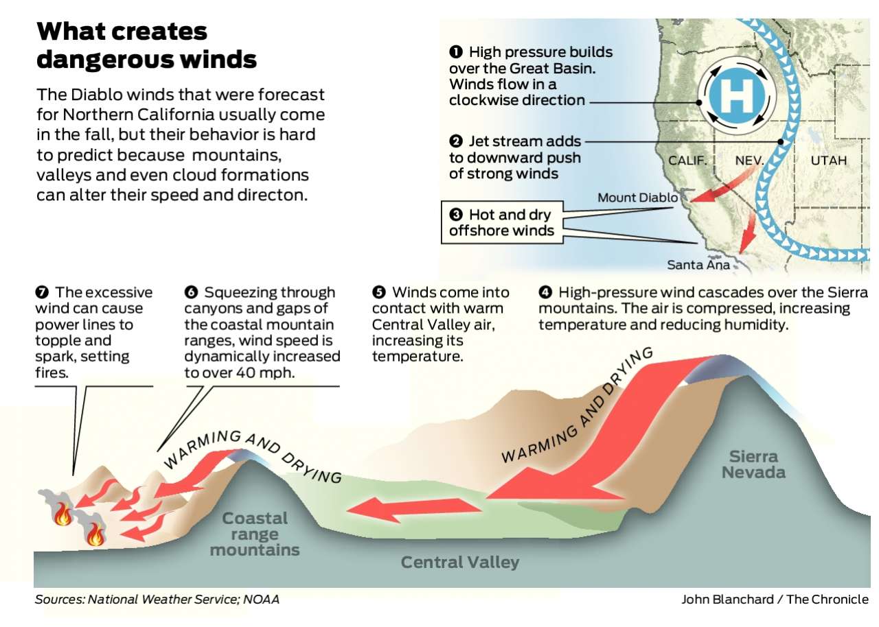
Diablo wind is a name that has been occasionally used for the hot, dry wind from the northeast that typically occurs in the San Francisco Bay Area of Northern California during the spring and fall.

The same wind pattern also affects other parts of California's coastal ranges and the western slopes of Sierra Nevada, with many media and government groups using the term Diablo winds for strong, dry downslope wind over northern and central California.[1]

Name

[edit]

The term first appeared shortly after the 1991 Oakland firestorm, perhaps to distinguish it from the comparable, and more familiar, hot dry wind in Southern California known as the Santa Ana winds. In fact, in decades previous to the 1991 fire, the term "Santa Ana" was occasionally used as well for the Bay Area dry northeasterly wind,[2] such as the one that was associated with the 1923 Berkeley Fire.[3]

The name "Diablo wind" refers to the fact that the wind blows into the inner Bay Area from the direction of Mount Diablo in adjacent Contra Costa County and evoking the fiery, sensationalist connotation inherent in "devil wind".

Formation

[edit]

The Diablo wind is created by the combination of strong inland high pressure at the surface, strongly sinking air aloft, and lower pressure off the California coast. The air descending from aloft as well as from the Coast Ranges compresses as it sinks to sea level where it warms as much as 20 °F (11 °C), and loses relative humidity.[4]

Because of the elevation of the coastal ranges in north-central California, the thermodynamic structure that occurs with the Diablo wind pattern favors the development of strong ridge-top and lee-side downslope winds associated with a phenomenon called the "hydraulic jump".[5] While hydraulic jumps can occur with Santa Ana winds, the same thermodynamic structure that occurs with them typically favors "gap" flow [6] more frequently. Santa Ana winds are katabatic, gravity-driven winds, draining air off the high deserts, while the Diablo-type wind originates mainly from strongly sinking air from aloft, pushed toward the coast by higher pressure aloft. Thus, Santa Anas are strongest in canyons, whereas a Diablo wind is first noted and blows strongest atop the various mountain peaks and ridges around the Bay Area.

In both cases, as the air sinks, it heats up by compression and its relative humidity drops. This warming is in addition to, and usually greater than, any contact heating that occurs as the air stream crosses the Central Valley and the Diablo Valley. This is the reverse of the normal summertime weather pattern in which an area of low pressure (called the California Thermal Low) rather than high pressure lies east of the Bay Area, drawing in cooler, more humid air from the ocean.

Impacts

[edit]

The dry offshore wind, already strong because of the offshore pressure gradient, can become quite strong with gusts reaching speeds of 40 miles per hour (64 km/h) or higher, particularly along and in the lee of the ridges of the Coast Range. This effect is especially dangerous with respect to wildfires as it can enhance the updraft generated by the heat in such fires. While the Diablo wind pattern occurs in both the spring and fall, it is most dangerous in the fall, when vegetation is at its driest. California's predominantly Mediterranean climate has an extended dry period from May through October.[7]

Effects tend to be halved at farther southern coasts, and even can spawn Sundowner winds in Santa Barbara. Although Santa Ana winds may recur, Diablo events in autumn tend to precede Santa Ana wind events by a few weeks with a lull in between as solar incidence declines. Southern Californian coasts from Ventura County south are generally unaffected by Diablo events.

See also

[edit]

References

[edit]
Revisions and contributorsEdit on WikipediaRead on Wikipedia
from Grokipedia
The Diablo wind is a hot, dry, and gusty northeasterly wind that periodically sweeps through Northern California's , particularly the region, originating from the of the Coast Ranges. Named after —meaning "devil" in Spanish due to its fierce nature—this phenomenon is analogous to the in , driven by a high-pressure system over the (such as ) and lower pressure along the coast, which funnels air downslope through canyons and passes, warming it by compression and drastically reducing . These winds typically emerge from late through early winter, peaking in when vegetation is driest, with average occurrences of about 2.5 events per year and gusts that can exceed 60 mph (97 km/h) in extreme cases, often channeling strongest along ridges, western slopes, and urban interfaces. Recent events, such as in and 2024, have prompted public safety power shutoffs due to heightened risks. Characterized as a type of or downslope windstorm, the Diablo wind forms when sinking air aloft under the high-pressure ridge compresses and accelerates as it descends the eastern slopes of the , creating a feature that intensifies surface winds and further desiccates the environment, sometimes raising daytime temperatures into the 90s°F (32–37°C) while allowing rapid nighttime cooling. This process can lower relative humidity to single digits and increase air temperatures by up to 20°F (11°C) through adiabatic warming, transforming already parched landscapes into highly flammable tinderboxes. Unlike more persistent regional winds, Diablo events are episodic, lasting from hours to several days, and are most hazardous in the fall dry season when live fuel moisture is at its lowest, exacerbating fire spread rates. The Diablo wind's most notable impacts revolve around its role in fueling catastrophic wildfires, as its speed and dryness propel embers and flames westward into populated areas, contributing to some of California's deadliest blazes. For instance, it has been linked to the rapid intensification of fires like the 2017 , which burned over 36,000 acres and claimed 22 lives in Sonoma County, driven by winds exceeding 50 mph that created extreme fire behavior. Historically, the term "Diablo wind" gained prominence after the 1991 Oakland Firestorm, which killed 25 people and destroyed nearly 3,000 structures amid similar gusty conditions, though earlier events such as the 1923 Berkeley Fire were retrospectively associated with these winds under the older label of "Santa Ana-type" flows. Beyond fire risk, the winds pose aviation hazards through , low visibility from smoke, and challenges at airports like those in the Bay Area, while also straining urban with downed power lines and debris. Research on projections for these winds varies, with some studies suggesting potential increases in duration or intensity.

Overview

Definition and Characteristics

The Diablo wind is a hot, dry, northeasterly that periodically affects the and , characterized by downslope flow from interior highlands. Named after due to its directional origin and the Spanish word "diablo" meaning , it evokes a devilish sensation through its intense heat, aridity, and gusty nature. Key physical properties include sustained wind speeds often exceeding 25 knots (29 mph or 47 km/h), with gusts frequently surpassing 40 mph (64 km/h) and reaching up to 60–90 knots (69–103 mph) in severe events, driven by the terrain-induced . As the air descends the coastal ranges, it undergoes adiabatic compression, resulting in significant temperature rises of up to 20°F (11°C) and relative levels that can plummet to single digits, exacerbating dryness through downslope warming. These winds typically peak in strength during nighttime or early morning hours, when stability enhances the downslope flow. Events generally last 1–3 days, with an average annual duration of about 52 hours based on reanalysis data, though individual episodes can extend longer during persistent synoptic patterns. The combination of high winds, elevated temperatures, and extreme low humidity creates conditions associated with heightened wildfire danger.

Geographical Extent

The Diablo wind primarily affects the San Francisco Bay Area in Northern California, extending eastward from the Central Valley through the Diablo Range and westward into coastal valleys such as those in Napa and Sonoma counties. This spatial domain is shaped by the region's complex topography, where the winds originate from high-pressure systems over the Great Basin and flow downslope across the Northern Coast Ranges. Topographic channeling plays a critical role in amplifying the winds, as they are funneled through narrow gaps in the Coast Ranges, including the and , where constriction causes acceleration and gusts exceeding 40 m/s in extreme cases. These passes act as conduits, directing the northeasterly flow southwestward into the Area lowlands, with the serving as a key barrier that enhances downslope acceleration on its lee side. The reach of the Diablo wind varies significantly across the landscape, with the strongest intensities occurring in inland valleys such as the Livermore Valley, where sustained speeds often reach 20-30 m/s due to minimal frictional . The winds weaken progressively southward toward and northward to Mendocino County, with minimal influence south of , where the coastal topography disrupts the offshore flow pattern. Elevation profoundly influences the wind's distribution, with peak intensities on windward slopes and ridges up to approximately 2,000 feet (610 m), particularly along the midslopes of the and Diablo Ranges. At escarpments, hydraulic jumps form as the accelerating flow encounters abrupt changes in terrain, leading to sudden increases in and on the lee sides. Events are less frequent below 300 m in the Bay Area, underscoring the role of orographic enhancement in confining the winds to elevated transitional zones.

Formation

Synoptic-Scale Conditions

The Diablo wind is primarily driven by a strong high-pressure system that develops over the or , which establishes a significant with low-pressure areas or troughs situated off the coast. This synoptic setup directs northeasterly surface flow toward the Pacific, channeling dry continental air masses across the Sierra Nevada and coastal ranges into . The high pressure typically builds as an extension of a broader ridge from the , amplifying the offshore component of the . Associated with this configuration are upper-level features, such as a at the 500-hPa level that intensifies eastward, promoting widespread and the formation of inversion layers over the region. These inversions stabilize the lower atmosphere, suppress formation, and maintain clear skies while trapping dry air near the surface. The enhances the dryness of the , setting the stage for stable, gusty conditions as the flow interacts with local . Diablo wind events are most commonly triggered in the fall, particularly from to , when cooling waters contrast with residual inland heat, strengthening the thermal and pressure contrasts. Spring occurrences, though less frequent, arise from post-winter rebuilding of over the interior, often following transient low-pressure systems. Overall, these events peak in , aligning with the transition from summer to winter synoptic patterns. Key observational indicators include significant surface pressure gradients between inland high-pressure centers and coastal lows, alongside northeasterly upper-level and relative below 30% for at least 3-6 hours, signal the onset of Diablo conditions that can accelerate through local dynamical processes.

Local Dynamical Processes

The Diablo wind arises from the interaction of synoptic-scale northerly flows with the regional topography of , particularly the Sierra Nevada and , where air descends the lee slopes in a foehn-like process. As the air mass flows over the windward slopes of the Sierra Nevada, it undergoes , releasing much of its moisture through or , resulting in a drier air parcel that then cascades downslope. Upon crossing the ridgeline, the flow accelerates and descends rapidly, experiencing adiabatic compression that warms the air by approximately 9.8°C per kilometer of loss and further reduces relative . This descent often involves a phenomenon, where the flow transitions from supercritical to subcritical states, generating and localized wind bursts that can exceed 25 m/s near the surface, with mountain waves contributing to the intensification. Wind acceleration is amplified by topographic channeling through mountain passes and canyons in the , where gap flows create a Venturi-like constriction that narrows the airflow and boosts velocities. Aloft, winds typically range from 20 mph (32 km/h) in the mid-troposphere, but surface gusts in these constricted areas can surpass 50 mph (80 km/h), with peaks reaching 30–40 m/s over secondary hills due to high regimes (Fr > 1) that minimize stability effects. This intensification occurs as the flow interacts with smaller-scale terrain features downstream of major ridges, producing intermittent bursts every 5–7 minutes that propagate erratically. Nocturnal drainage plays a key role in enhancing the thermal structure, as cooling at higher elevations promotes katabatic flows that merge with the descending Diablo air, fostering a surface-based inversion. This inversion, often developing below 1,000 feet (300 m) with potential temperature lapse rates inverting to stable conditions (N ≈ 0.015 s⁻¹), traps warmer air aloft and prevents at the surface, sustaining elevated temperatures overnight. The process intensifies the overall warming, with adiabatic descent combined with turbulent mixing over rough contributing to rapid near-surface heating. Humidity reduction is primarily driven by the initial orographic lift over the Sierra Nevada, which extracts moisture from the , leaving it desiccated before the lee-side descent; subsequent compressional heating further lowers relative to below 30%, often approaching 10% or less. Evaporative cooling from any residual moisture is negligible in this dry continental air, as the stable layer inhibits vertical mixing and plume growth, maintaining arid conditions that exacerbate fuel dryness.

Climatology

Seasonal and Temporal Patterns

The Diablo wind events predominantly occur during the autumn months, from to , which coincide with the onset of Northern California's and account for the majority of annual occurrences. This seasonal peak aligns with the development of persistent high-pressure systems over the , fostering the northeasterly flow characteristic of these winds. In contrast, spring events, typically from to May, represent a smaller fraction of occurrences, arising during transitional patterns that occasionally produce similar downslope conditions. Diurnally, Diablo winds exhibit a distinct cycle, with peak intensities from late afternoon through dawn, driven by stable nocturnal inversions that channel downslope flow. Winds weaken during midday hours due to solar heating, which disrupts these inversions and reduces the katabatic forcing along the coastal ranges. This pattern results in the strongest gusts often observed overnight and into early morning, enhancing fire weather risks during these periods. Events frequently cluster in sequences that precede or follow episodes, as the clearing of post-rain atmospheric stability allows high-pressure ridges to dominate. Multi-day episodes, lasting 5 to 7 days on average under persistent blocking highs, amplify the cumulative drying effects and elevate regional danger. Such clustering is common during extended periods of offshore flow, with individual events persisting for at least 6 consecutive hours. Long-term variability in Diablo wind shows connections to large-scale modes. Over the period from 1979 to 2018, annual event averaged about 2 per year with no significant overall trend, though interannual fluctuations exhibit periodicity of 2 to 4 years. Intensity variations tend to be more pronounced in autumn compared to spring. Historical records indicate that Diablo winds occur with a annual of approximately 2.5 major events in the , based on a 17-year climatological study using surface observations and reanalysis data from 2001 to 2017. Over a longer period from 1979 to 2018, analysis of reanalysis datasets identified approximately 2 events per year on average, with no significant long-term trend in overall but quasi-periodic variations every 2-4 years. Diablo winds typically feature gusts of 35-55 mph (56-89 km/h) during events, as observed across the Bay Area. Extreme events can exceed 70 mph (113 km/h), with recorded gusts reaching up to 90 mph (145 km/h) in downslope areas like the during severe occurrences. Trends in Diablo wind frequency show a significant increase in late fall events since the late , potentially linked to enhancing inland-offshore pressure gradients, though overall annual frequency remains stable without significant shifts in maximum intensities according to reanalysis-based studies. More recent research as of indicates increases in the frequency of extreme weather events associated with such winds. Projections suggest possible increases in event duration under future warming scenarios, driven by altered large-scale circulation patterns. Notably, minimum relative during events has decreased, particularly in , amplifying dryness and risk. Forecasting of Diablo winds relies on numerical models such as the Weather Research and Forecasting (WRF) model, which simulates mesoscale dynamics and predicts gust magnitudes for high-impact events in the Bay Area. The National Weather Service issues Red Flag Warnings when sustained winds exceed 25 mph (40 km/h) combined with relative humidity below 15%, signaling elevated fire weather potential during Diablo conditions.

Impacts

Role in Wildfire Ignition and Spread

Diablo winds significantly contribute to elevated fire weather indices in by combining extreme low —often dropping below 10%—with gusty speeds that desiccate fine fuels like grasses and shrubs to critical moisture levels under 10%, priming landscapes for rapid ignition and high spread rates. These conditions align with the National Fire Danger Rating System's emphasis on wind-driven fire behavior, where sustained winds exceeding 20 mph (32 km/h) can elevate the fire weather index to very high or extreme categories, facilitating spread rates in grasslands and light fuels up to 5 mph (8 km/h) under Diablo events. The winds' downslope acceleration further erodes fuel moisture through adiabatic compression, exacerbating aridity beyond baseline effects. Ignition risks intensify during Diablo wind episodes as the gusts, often surpassing 50 mph (80 km/h), sway or snap overhead power lines and , generating sparks that readily ignite parched grasslands and with fuel moistures below 10%. Vehicle-related sparks or equipment malfunctions also pose heightened threats, as the dry, finely divided fuels ignite with minimal input under these conditions. Once ignited, the winds propel embers and firebrands 1-2 miles (1.6-3.2 km) ahead of the flame front via long-range spotting, establishing multiple ignition points and fragmenting fire perimeters. The spread dynamics of wildfires under Diablo winds are amplified by the event's katabatic flow, which generates turbulent downslope gusts that foster fire whirls—rotating columns of and embers—and promote convective spotting over topographic barriers. These mechanisms align fronts with and continuity, sustaining high-intensity runs. In complex terrain like the North Coast ranges, the winds' channeling through valleys accelerates head fire advance, overwhelming suppression efforts and extending fire duration. Notable examples illustrate these impacts, such as the 2018 Camp Fire, where Diablo winds gusting over 50 mph (80 km/h) drove the blaze's explosive growth, resulting in 85 fatalities and the destruction of 153,336 acres (62,116 hectares) through rapid spotting and wind-aligned spread. Similarly, the 2017 , fueled by Diablo gusts exceeding 70 mph (113 km/h) and up to 96 mph (154 km/h) in peaks, leveled 5,636 structures across Sonoma and Napa counties by facilitating ember transport and formation, underscoring the winds' role in urban-wildland interface devastation.

Effects on Weather and Environment

Diablo winds, characterized by strong, dry, and hot northeasterly gusts originating from the and channeled through the and Central Valley, significantly alter local patterns in Northern California's Bay Area and surrounding regions. These winds undergo adiabatic compression as they descend the [Diablo Range](/page/Diablo Range), leading to rapid warming and relative drops often below 10%, which can produce temporary with daytime temperatures in valleys reaching 90–100°F (32–38°C). Additionally, the high winds, with gusts frequently exceeding 50 mph and occasionally surpassing 80 mph, can lift fine particles from dry soils and exacerbate atmospheric aridity. The ecological consequences of Diablo winds extend beyond immediate drying to long-term stress on native ecosystems, particularly in shrublands and woodlands prevalent in the Ranges and . The intense, low-humidity airflow accelerates vegetation , weakening plant tissues and reducing , which compromises the resilience of drought-adapted like and . This contributes to increased vulnerability to secondary stressors, such as infestations in coniferous stands, resulting in widespread tree mortality. Furthermore, the forceful gusts promote on exposed slopes, stripping and , which diminishes quality and nutrient cycling in post-event recovery periods. Diablo winds also influence regional air quality by facilitating the downslope transport of pollutants from the agriculturally intensive and urbanized Central Valley into the Bay Area. These northeasterly flows carry fine particulate matter (PM2.5), volatile organic compounds, and nitrogen oxides accumulated in the valley, elevating ambient PM2.5 concentrations during episodes and compromising air quality standards in receptor areas like the . The dry conditions suppress vertical mixing, allowing these pollutants to persist at ground level and interact with local emissions, thereby intensifying photochemical formation under sunny conditions. On human scales, Diablo winds impose notable environmental burdens, including heightened demands for cooling during associated episodes, as residential and commercial usage surges to mitigate the elevated temperatures and low humidity. While structural remains rare compared to coastal storms, extreme gusts can topple unsecured objects, lightweight , and occasionally stress utility lines, though the primary concerns stem from the arid conditions promoting and respiratory irritation among exposed populations. These effects are compounded by the winds' role in amplifying risk, though non-combustive impacts dominate everyday environmental strain.

Historical Events

Pre-20th Century and Early Records

The earliest documented observations of winds resembling the modern Diablo wind phenomenon date back to the mid-19th century, when systematic weather recording began in the . Weather conditions have been observed in since 1847 when the first observations were made at the . These records noted , and force, sky conditions, and ; they occasionally described strong northerly or northeasterly winds that dispersed the region's persistent coastal fog, though no specific term like "Diablo" was applied at the time. Such observations continued sporadically through the 1860s in city directories and Army reports, associating these downslope flows with seasonal dryness but lacking quantitative analysis or event-specific tracking. In 19th-century accounts from California's Central Valley regions, these northeasterly winds were commonly termed "northers," recognized for their hot, dry characteristics that could damage crops like and , particularly during May through July. Historical texts from the era, such as geological surveys and journals, described "northers" as intense, arid gusts originating from inland high-pressure systems, but without formal meteorological networks, records remained anecdotal and localized to agricultural impacts rather than risks. No systematic climatological study or naming convention for Bay Area variants existed before , limiting recognition to qualitative entries and regional reports. The transition to the 20th century marked the first major documented incident linking these winds to significant destruction: the Berkeley Fire of September 17, 1923. Ignited near the San Pablo Ridge around noon, the blaze was rapidly propelled by hot, dry northeasterly winds gusting to approximately 40 miles per hour, which dried vegetation and scattered embers, ultimately destroying 584 buildings across 130 acres and displacing nearly 4,000 residents, including University of California students. The fire was contained only after the winds shifted in the late afternoon, highlighting the phenomenon's fire-fueling potential in an era of increasing urban development adjacent to wildlands. This event underscored the need for better awareness, though the specific term "Diablo wind" did not emerge until later decades.

20th and 21st Century Incidents

The 1991 Oakland firestorm, ignited on October 19 in the Oakland Hills, was dramatically exacerbated by Diablo winds gusting over 60 , which reignited embers and propelled the fire across 1,520 acres, destroying 3,354 single-family homes and 4,375 other structures while killing 25 people and injuring 150 others. This event, one of the most destructive urban wildfires in U.S. history, prompted the widespread adoption of the term "Diablo winds" to describe the downslope gusts originating from the northeast, distinguishing them from similar phenomena in . In October 2017, a series of Diablo wind events fueled the North Bay fires, including the , with gusts reaching up to 75 miles per hour across the region, driving flames through densely vegetated canyons and urban interfaces. These winds contributed to the complex burning approximately 245,000 acres over eight counties, destroying over 8,900 structures and resulting in 44 fatalities, with the Tubbs Fire alone claiming 22 lives and 5,636 buildings. The 2018 Camp Fire in Butte County, ignited on , was intensified by Diablo-like winds with speeds nearing 50 , allowing the blaze to rapidly consume 153,336 acres and obliterate the town of Paradise along with 18,804 structures. This catastrophe, the deadliest in history with 85 fatalities, highlighted the vulnerability of northern Sierra foothill communities to such wind-driven fire spread. Subsequent notable incidents include the 2021 , which burned 963,309 acres in five northern counties, though the event was primarily driven by prolonged dry conditions. In October 2024, the Keller Fire in Oakland was fanned by Diablo winds with gusts exceeding 50 (80 km/h), spreading across 56 acres, destroying 12 structures, damaging others, and injuring two firefighters before being contained. These modern events have underscored the Diablo winds' role in amplifying fire behavior in the Bay Area and beyond. In response to these disasters, particularly after the 2018 Camp Fire—which was linked to utility infrastructure failure during high winds— implemented enhanced mitigation measures, including expanded public safety power shutoffs (PSPS) by utilities like PG&E to proactively de-energize lines during forecasted Diablo wind events, alongside improved evacuation protocols and early warning systems that have reduced ignition risks and facilitated faster community responses in subsequent high-wind periods.

Comparisons

Similarities and Differences with Santa Ana Winds

The Diablo winds and share fundamental meteorological characteristics as katabatic, downslope winds originating from high-pressure systems over the deserts and lower pressure along the coast, which drive northeasterly to easterly airflow toward the Pacific. This shared synoptic pattern results in adiabatic compression during descent, producing hot, dry conditions with relative humidity often dropping below 30%, exacerbating vegetation desiccation and elevating ignition and spread risks during their primary season of late fall to early winter. Both wind regimes are classified as foehn-type events, where sinking air warms and dries, typically peaking in when fuels are seasonally parched, and they can generate gusts exceeding 60 mph near terrain features, intensifying fire behavior through rapid flame front advancement. Despite these parallels, the Diablo winds and diverge in geography, airflow channeling, and event scale. Geographically, Diablo winds primarily impact northern and , channeled from the northeast through the toward the , whereas affect , flowing from the east-northeast across the San Bernardino and into valleys like the . In terms of channeling, Diablo winds are more pronounced along ridges and western slopes of the Coast Ranges, with less confinement to narrow passes, leading to broader but somewhat diffuse impacts; , by contrast, intensify through canyon gaps and passes, creating more focused, high-velocity jets in urban-wildland interfaces. Diablo events are generally shorter-lived, often lasting 1-3 days with multi-hour peaks overnight to morning, while Santa Ana episodes can persist 3-7 days on average, allowing for prolonged fire progression. Impact variances further highlight their distinctions, though both heighten fire danger through low and gusts. Santa Ana winds have fueled larger-scale conflagrations, such as the 2003 , which burned over 280,000 acres under sustained gusts exceeding 60 mph and below 10%, due to their extended duration and extensive southern coverage. In comparison, Diablo winds tend to produce more localized effects in the Bay Area and , as seen in the 2017 Wine Country fires where gusts of 60-90 knots drove rapid spread but were confined to regional ridges. This localization stems from Diablo winds' ridge-oriented flow, contrasting with the canyon-amplified, broader fire corridors of .

Relations to Other Regional Wind Phenomena

The Diablo wind shares key characteristics with other downslope wind phenomena across the , particularly in its warm, dry nature driven by adiabatic compression as air descends mountain slopes. In the , it is analogous to Chinook winds, which also produce rapid warming and drying through similar downslope flow, though Chinooks often occur in winter and can melt snow more dramatically due to colder baseline temperatures east of the divide. Unlike Chinooks, Diablo winds rarely involve significant snowfall and are more tied to autumn fire seasons in . Internationally, the along the eastern in exhibits comparable compression warming and dry conditions during downslope descent, peaking in winter and enhancing aridity in foothill regions. Within , Diablo winds often precede or interact with Mono winds along the western slopes of the central Sierra Nevada, both representing strong, gusty northeasterly flows under amplified upper-level ridging and high pressure that foster downslope acceleration. These winds peak from to for Mono events, contrasting with Diablo's primary focus, but share synoptic setups involving coastal troughs that channel dry air westward. In opposition to these offshore patterns, Diablo winds starkly contrast with the cool, moist onshore flows of the marine layer, which advect and stratus clouds from the Pacific, maintaining higher humidity and suppressing temperature extremes along the coast. Globally, Diablo winds align with classic dynamics observed in the European , where downslope flows generate hydraulic jumps—abrupt transitions from supercritical to subcritical flow states that amplify gusts and warming on the lee side of ranges like the . These jumps, evident in Diablo events through numerical modeling of mountain-wave breaking, contribute to extreme wind speeds exceeding 30 m s⁻¹ in both regions. In , equivalents include south foehn winds over Japan's Toyama Plain, which similarly warm and dry air via dynamical descent ahead of cyclones, though they incorporate more subtropical moisture influences than the arid Diablo setup. Diablo winds form part of broader North American seasonal transitions following the retreat of the summer , which shifts moisture patterns southward and allows persistent high pressure over the to dominate fall synoptics. They occasionally link to pressure gradients involving lows near the , where strengthened geopotential heights enhance northeasterly flow across , correlating with La Niña phases that reduce Pacific storm activity.

References

Add your contribution
Related Hubs
User Avatar
No comments yet.