Recent from talks
Contribute something
Nothing was collected or created yet.
Brenner Pass
View on Wikipedia

Key Information
The Brenner Pass (German: Brennerpass [ˈbʁɛnɐpas], in short Brenner; Italian: Passo del Brennero [ˈpasso del ˈbrɛnnero]) is a mountain pass over the Alps which forms the border between Italy and Austria. It is one of the major passes of the Eastern Alpine range and has the lowest altitude among Alpine passes of the area.
Dairy cattle graze in alpine pastures throughout the summer in valleys beneath the pass and on the mountain slopes. At lower altitudes, farmers log pine trees, plant crops and harvest hay for winter fodder. Many of the high pastures are at an altitude of over 1,500 metres (4,900 feet); a small number stand high in the mountains at around 2,000 metres (6,600 feet).
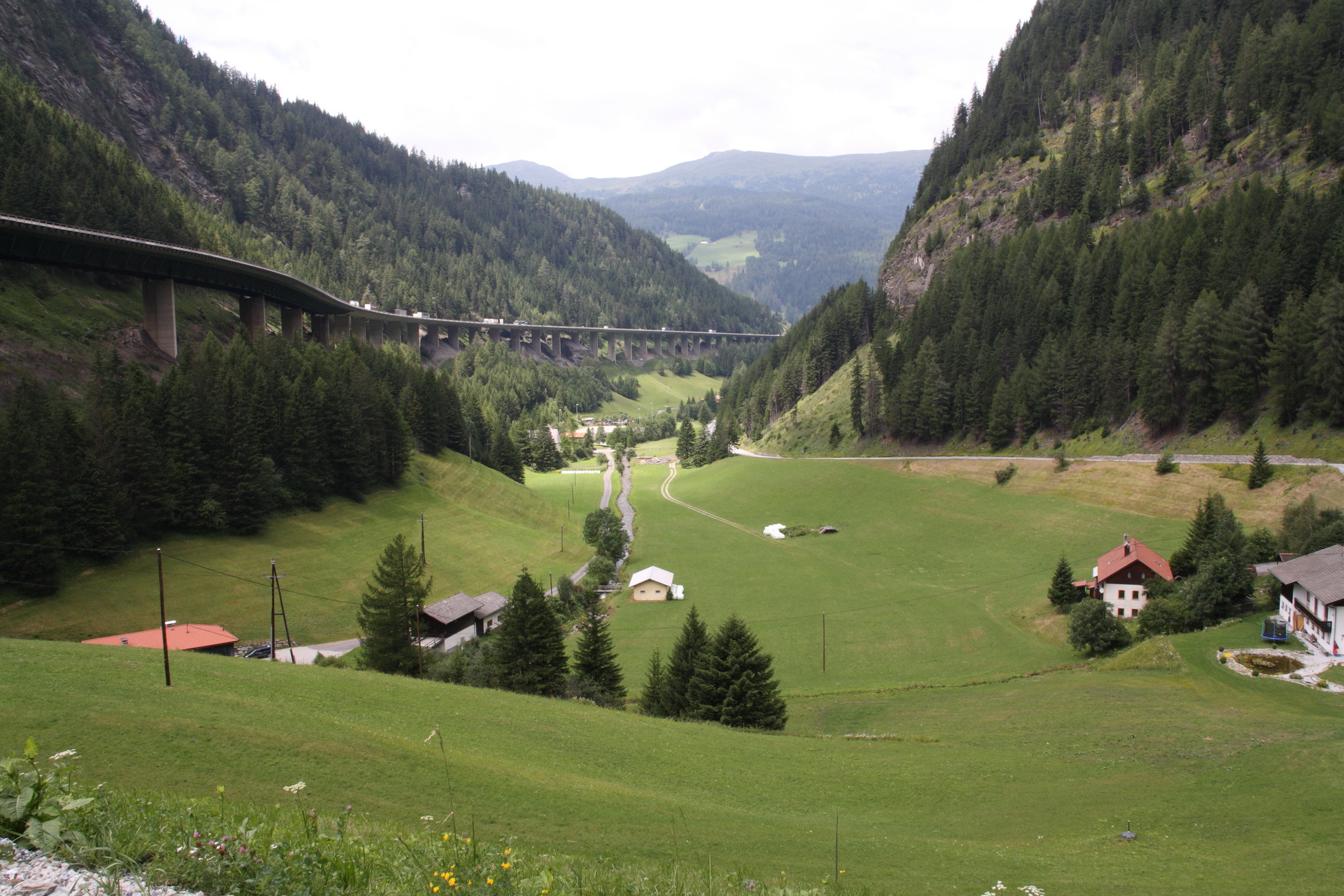
The central section of the Brenner Pass covers a four-lane motorway and railway tracks connecting Bozen/Bolzano in the south and Innsbruck to the north. The village of Brenner consists of an outlet shopping centre (supermarkets and stores), fruit stores, restaurants, cafés, hotels and a gas station. It has a population of 400 to 600 (as of 2011[update]).
Etymology
[edit]Older, obsolete theories suggested a connection of the name Brenner with the ancient tribe of the Breuni or the Gaulish chieftain Brennus, but since the pass name appears for the first time only in the 14th century, a more recent etymology is far more likely.[1]
"Prenner was originally the name of a nearby farm, which was named after its former owner. The farm of a certain Prennerius is mentioned in documents in 1288; a certain Chunradus Prenner de Mittenwalde is mentioned in 1299. The German word Prenner probably refers to somebody who uses slash-and-burn techniques for land clearing. A name for the pass itself appears for the first time in 1328 as ob dem Prenner (German for above the Prenner).[2]
History
[edit]Roman Empire
[edit]
The Romans regularised the mountain pass at Brenner, which had already been under frequent use during the prehistoric eras since the most recent Ice Age.[3] The Brenner Pass, however, was not the first trans-Alpine Roman road to become regularised under the Roman Empire.
The first Roman road to cross the Alpine range, Via Claudia Augusta, connected Verona in northern Italy with Augusta Vindelicorum (modern-day Augsburg) in the Roman province of Raetia. Via Augusta was completed in 46–47 AD; the route took its course along the Adige valley to the neighbouring Reschen Pass (west of the Brenner Pass), then descended into the Inn valley before rising to Fern Pass towards Augsburg.
The Roman road that physically crossed over the Brenner Pass did not exist until the 2nd century AD. It took part of the "eastern" route up the Eisack Valley and descended into Veldidena (modern-day Wilten), where it crossed the Inn and into Zirl and arrived at Augsburg via Füssen.
The Alamanni (Germanic tribe) crossed the Brenner Pass southward into modern-day Italy in 268 AD, but they were stopped in November of that year at the Battle of Lake Benacus. The Romans kept control over the mountain pass until the end of their empire in the 5th century.[4]
Holy Roman Empire
[edit]During the High Middle Ages, Brenner Pass was a part of the important Via Imperii, an imperial road linking the Kingdom of Germany north of the Alps with the Italian March of Verona. In the Carolingian Divisio Regnorum of 806, the Brenner region was called per alpes Noricas, the transit through the Noric Alps.[5] From the 12th century, the Brenner Pass was controlled by the Counts of Tyrol within the Holy Roman Empire. Emperor Frederick Barbarossa made frequent use of the Brenner Pass to cross the Alps during his imperial expeditions into Italy.[6] The 12th-century Brenner Pass accommodated mule trains and carts.
Modernisation of the Brenner Pass started in 1777, when a carriage road was laid out at the behest of Empress Maria Theresa.
Austrian Empire
[edit]Modernisation further took place under the Austrian Empire and the Brenner Railway, which was completed in stages from 1853 to 1867. It became the first trans-Alpine railway without a major tunnel and at high altitude (crossing the Brenner Pass at 1,371 m). Completion of the railway enabled the Austrians to move their troops more efficiently; they had hoped to secure their territories of Venetia and Lombardy (south of the Alps), but lost them to Italy following the Second Italian War of Independence in 1859 and Austro-Prussian War in 1866.[citation needed]
Recent history
[edit]At the end of World War I in 1918, the control of the Brenner Pass became shared between Italy and Austria under the Treaty of Saint-Germain-en-Laye (1919). The Treaty of London (1915) secretly awarded Italy the territories south of the Brenner Pass for supporting the Entente Powers. Welschtirol/Trentino, along with the southern part of the County of Tyrol (now South Tyrol), was transferred to Italy, and Italian troops occupied Tyrol and arrived at the Brenner Pass in 1919 to 20.

On 12 March 1938, Austria was annexed by Germany. Two years and six days later during World War II, Adolf Hitler and Benito Mussolini met at the Brenner Pass to celebrate their Pact of Steel on 18 March 1940. Later, in 1943, following the Italian armistice with the Allies, the Brenner Pass was annexed by Nazi Germany, shifting the border with the Italian Social Republic, the Nazi puppet state headed by Mussolini, much further south. In 1945, the area was occupied by the US Army and returned to Italy after the end of the war. The Brenner Pass was part of the ratlines that were used by senior Nazis fleeing the allies after the German surrender in 1945.
Following World War II, the pass once again formed the border between Italy and the newly independent Republic of Austria, and maintained its importance as a key trade route. On 1 January 1995 the Schengen Agreement entered into force in Austria, a treaty Italy ratified on 26 October. As a consequence, border checks were abolished in the Brenner Pass for goods and people between the two countries. On 19 November 1995 the border barrier between Italy and Austria at Brenner was officially abolished, with a commemoration attended by Austrian Minister of the Interior Karl Schlögl, Italian Minister of the Interior Giorgio Napolitano, and the governors of Innsbruck and Bolzano.[7]
| Brenner Pass | ||||||||||||||||||||||||||||||||||||||||||||||||||||||||||||
|---|---|---|---|---|---|---|---|---|---|---|---|---|---|---|---|---|---|---|---|---|---|---|---|---|---|---|---|---|---|---|---|---|---|---|---|---|---|---|---|---|---|---|---|---|---|---|---|---|---|---|---|---|---|---|---|---|---|---|---|---|
| Climate chart (explanation) | ||||||||||||||||||||||||||||||||||||||||||||||||||||||||||||
| ||||||||||||||||||||||||||||||||||||||||||||||||||||||||||||
| ||||||||||||||||||||||||||||||||||||||||||||||||||||||||||||
Motorway
[edit]The motorway E45 (European designation; in Italy A22, in Austria the A13), Brenner Autobahn/Autostrada del Brennero, begins in Innsbruck, runs through the Brenner Pass, Bozen/Bolzano, Verona and finishes outside Modena. It is one of the most important routes of north–south connections in Europe.
After the signing of the Schengen Agreement in 1992 and Austria's subsequent entry into the European Union in 1995, customs and immigration posts at the Brenner Pass were removed in 1997. However, Austria reinstituted border checks in 2015 as a response to the European migrant crisis. In April 2016, Austria announced it would build a 370-meter long fence at the Pass but clarify that "it would be used only to "channel" people and was not a barrier.[8]"
The Europabrücke (Europe Bridge), located roughly halfway between Innsbruck and the Brenner Pass, is a large concrete bridge carrying the six-lane Brenner Autobahn over the valley of Sill River (Wipptal). At a height of 180 metres (590 feet) and span of 820 metres (2,690 feet), the bridge was celebrated as a masterpiece of engineering upon its completion in 1963. It is a site where bungee-jumping from the bridge has become a popular tourist attraction.[citation needed]
The ever-increasing freight and leisure traffic, however, has been causing long traffic jams at busy times even without border enforcements. The Brenner Pass is the only major mountain pass within the area; other nearby alternatives are footpaths across higher mountains at an altitude of above 2,000 metres (6,600 feet). As a result, air and noise pollution have generated heavy debate in regional and European politics. As of 2004[update], about 1.8 million trucks crossed the Europa Bridge per year.[9]
Railway
[edit]In order to ease the road traffic, there are plans to upgrade the Brenner Railway from Verona to Innsbruck with a series of tunnels, including the Brenner Base Tunnel underneath Brenner.[10] The official groundbreaking of the tunnel took place in 2006 (with survey tunnels drilled in the same year), but substantial work did not begin until 2011. Funding issues have delayed the tunnel's scheduled date of completion from 2022 to no earlier than 2032.[11]
See also
[edit]References
[edit]- ^ Alois Trenkwalder: Brenner. Bergdorf und Alpenpaß – Brennero. Storia di un paesino e di un valico internazionale. Brenner 1999, p. 72 (online Archived 23 August 2019 at the Wayback Machine)
- ^ Egon Kühebacher (1991). Die Ortsnamen Südtirols und ihre Geschichte, Bozen: Athesia, p. 59
- ^ Walter Woodburn Hyde (1935). Roman Alpine Routes (Philadelphia: University of Pennsylvania Press), p. 194: "the use of the major pass-routes has been continuous from prehistoric times down to the present".
- ^ "Geschichte Schwabens bis zum Ausgang des 18. Jahrhunderts" by Max Spindler, Christoph Bauer, Andreas Kraus, 3rd edition; publisher: C.H. Beck Verlag 2001, page 80 ISBN 3-406-39452-3, ISBN 978-3-406-39452-2
- ^ Martin Bitschnau; Hannes Obermair (2009). Tiroler Urkundenbuch, II. Abteilung: Die Urkunden zur Geschichte des Inn-, Eisack- und Pustertals. Vol. 1: Bis zum Jahr 1140 (in German). Innsbruck: Universitätsverlag Wagner. pp. 51–52 no. 73. ISBN 978-3-7030-0469-8.
- ^ Santosuosso, Antonio (2004). Barbarians, Marauders, and Infidels: The Ways of Medieval Warfare. New York: MJF Books. p. 190. ISBN 978-1-56731-891-3.
- ^ Michael Gehler, Der Brenner: Vom Ort negativer Erfahrung zum historischen Gedächtnisort oder zur Entstehung und Überwindung einer Grenze in der Mitte Europas (1918-1998), in Idem, Andreas Pudlat (a cura di), Grenzen in Europa, Hildesheim-Zurigo-New York, 2009, pp. 145-182.
- ^ Scherer, Steve; Pullella, Philip; Jones, Gavin; Roche, Andrew (28 April 2016). "Italy, Austria seek to calm tensions over Brenner border controls". Reuters. Reuters. Archived from the original on 26 November 2018. Retrieved 2 May 2016.
On Wednesday, Austria outlined plans to erect a 370 meter-long fence at the Brenner Pass, which is the busiest route through the Alps for heavy goods vehicles, but Sobotka said on Thursday it would be used only to "channel" people and was not a barrier.
- ^ [1] [dead link]
- ^ Galleria di Base del Brennero – Brenner Basistunnel BBT SE – Offline Archived 22 December 2005 at the Wayback Machine
- ^ "Governors protest latest delay to Brenner Base Tunnel construction". railjournal.com. 27 May 2021. Archived from the original on 1 February 2022. Retrieved 12 January 2022.
External links
[edit]- Coolidge, William Augustus Brevoort (1911). . Encyclopædia Britannica. Vol. 4 (11th ed.). pp. 495–496.
- Webcam Brenner Pass
Brenner Pass
View on GrokipediaThe Brenner Pass is a mountain pass through the Eastern Alps forming the Austria–Italy border, situated at an elevation of 1,370 meters (4,495 feet) above sea level between the Austrian municipality of Brenner and the Italian municipality of Brennero.[1][2]
It serves as one of the lowest crossings of the main Alpine chain, linking Innsbruck in Austria's Tyrol with Bolzano in Italy's South Tyrol and enabling a primary north–south trade corridor between Central Europe and the Mediterranean basin.[3]
Utilized since Roman times for military and commercial purposes via an early road network, the pass gained prominence as a medieval trade route and saw infrastructure upgrades including a carriage road in 1772 and a railway in 1867, solidifying its role in trans-Alpine connectivity.[4][5]
Today, it handles substantial volumes of road and rail traffic—exceeding 2.5 million trucks, 14 million cars, and 50 million tonnes of goods annually—prompting the development of the Brenner Base Tunnel to shift freight to rail and mitigate road congestion and emissions.[6][7]
Geography and Physical Features
Location and Topography
The Brenner Pass constitutes the lowest major crossing of the Eastern Alps' main chain, situated at an elevation of 1,370 meters (4,495 feet) above sea level, which enables relatively consistent accessibility compared to higher surrounding passes.[8][9] This altitude marks it as the principal low-elevation route through the Alpine barrier in the region, with the pass's saddle point facilitating drainage and passage without extreme gradients typical of steeper northern Alpine routes.[10] Positioned along the international border between Austria and Italy, the pass lies approximately 40 kilometers southeast of Innsbruck in Austria's Tyrol state and 50 kilometers north of Bolzano in Italy's South Tyrol province, at coordinates roughly 47°00′N 11°30′E.[11] North of the pass, the Wipptal valley follows the Sill River, a tributary of the Inn River, providing northward drainage toward the Danube basin, while southward, the Eisack (Isarco) River valley descends into the Adige basin.[5] The topography features a broad, U-shaped glacial valley flanked by rugged peaks of the surrounding Alpine subgroups, including the Stubai Alps to the west with summits like the Zuckerhütl at 3,507 meters and the Zillertal Alps to the east. This morphology, shaped by Pleistocene glaciation, results in gentler slopes at the pass itself relative to adjacent higher terrain, with average elevations in the immediate vicinity exceeding 1,600 meters.[1] The Sill River's course through the northern approach underscores the pass's hydrological divide between northern and southern European watersheds.[12]Geology and Climate
The Brenner Pass lies within the Eastern Alps, where the underlying geology consists primarily of units from the Austroalpine nappe system, including polymetamorphic basement rocks of the Merano-Mules unit and overlying Permian to Triassic carbonate sequences dominated by limestone and dolomite formations.[13] These carbonates form the thick-bedded massifs typical of the region's morphology, with the pass transect exposing a stack of far-traveled nappes thrust over underlying Penninic units during Alpine orogenesis.[14] Pleistocene glaciations further shaped the pass through erosional carving, depositing Quaternary glacial tills and moraine-like features amid the steep valleys of the Isarco and Sill rivers.[13] [15] Tectonically, the pass is bounded by the Brenner Fault Zone, a Miocene low-angle normal fault that accommodated orogen-parallel extension in the Eastern Alps, contrasting with the ongoing compressional and strike-slip regimes more prevalent in the seismically active western sectors.[16] [17] This extensional history contributes to relative tectonic quiescence today, though the steep, fractured metamorphites and gravitational slope deformations (DSGSDs) render slopes susceptible to instability, as evidenced by a cluster of five catastrophic rock-slope failures near the pass, with deposit volumes ranging from 12 to 110 million cubic meters.[18] These events, often triggered by rockfalls evolving into avalanches, highlight ongoing hazards from structural weaknesses along Neogene fault zones rather than primary seismic activity.[18] The climate at the 1,370-meter elevation pass is continental with alpine influences, featuring mean monthly temperatures of approximately -5°C in January and 15°C in July, based on long-term simulations.[19] Annual precipitation totals around 800 mm, with much falling as snow due to orographic effects, leading to persistent snow cover from November through April that exacerbates seasonal accessibility challenges.[19] Cold winters include frequent subzero minima, while summers remain mild, supporting sparse vegetation but limiting perennial snowfields compared to higher elevations.[19]Etymology
Linguistic Origins and Historical Naming
The name Brenner originates from the Middle High German verb brennen, meaning "to burn," associated with local practices such as slash-and-burn clearing or charcoal burning in the heavily forested alpine borderlands.[20] This etymology ties the designation to medieval economic activities rather than ancient tribal names or folklore, with pre-Roman inhabitants including the Breones and Isarci tribes documented in the region but not directly linked to the pass's modern appellation.[21] The earliest historical attestation appears in a 1288 urbar (feudal estate register) of Count Meinhard II of Tyrol, recording "Prennerius de Mittenwalde," referring to a farmstead owner in the vicinity whose surname derives from the same root.[20] A similar reference to "Chunradus Prenner de Mittenwalde" follows in 1299 documents.[20] By 1338, "Brenner" had evolved into the standard term for the pass's location, replacing earlier toponyms like Mittenwald (middle forest) as the site's strategic farm gained prominence in trade records.[20] This medieval Latin-influenced form, akin to Brennerium in administrative texts, underscores the pass's role as a demarcation between Germanic-speaking northern territories and Romance-language areas to the south, though the name itself remained firmly Germanic.[21] Earlier conjectures tying it to Celtic Brennus (a Gaulish chieftain) or the Breuni tribe—extant until the 9th–10th centuries CE in the Eisack and Inn valleys—lack documentary support and are considered obsolete. The nomenclature stabilized distinctly from adjacent routes like the Timmelsjoch, avoiding conflation in 14th-century commerce ledgers.[20]History
Prehistoric and Roman Era
The Brenner Pass exhibits evidence of human traversal dating to the Mesolithic period, with bioarchaeological isotopic mapping of faunal and human remains from sites in the Inn-Eisack-Adige corridor confirming mobility across the Alps via this route as early as the post-glacial recolonization phase.[22] This prehistoric utilization persisted through the Neolithic and into the Bronze Age, facilitating migrations and resource exchanges amid a landscape of hunter-gatherer adaptations and early metallurgical activities in adjacent valleys.[23] Roman engineering transformed the pass into a structured thoroughfare beginning in 15 BCE, when Nero Claudius Drusus, during campaigns against the Raeti, oversaw the initial paving and fortification of Alpine routes, including the Brenner corridor, to secure military supply lines from northern Italy to emerging provinces.[24] Subsequent improvements under Emperor Claudius circa 46–47 CE extended this infrastructure, with the development of graded paths, bridges, and drainage systems—collectively termed the Via Claudia Augusta in its broader network—enabling legionary movements and mercantile traffic that bypassed hazardous seasonal floods and reduced crossing durations from protracted seasonal treks to organized marches of approximately five days.[4] Surviving artifacts, such as inscribed milestones and paved segments near the pass summit, underscore the emphasis on logistical efficiency for troop deployments toward the Danube frontiers.[25] These enhancements prioritized conquest and control, as evidenced by auxiliary fortifications like the settlement at Veldidena (modern Innsbruck), which served as a staging post for operations integrating the pass into Rome's northern defenses.[26]Medieval Period and Holy Roman Empire
The Brenner Pass functioned as a critical artery for medieval trade and communication within the Holy Roman Empire, channeling merchants, pilgrims, armies, and goods between northern Europe and Italy via the Alpine crossing. Feudal oversight of the southern approaches rested with the Prince-Bishopric of Trent, an ecclesiastical principality whose authority extended to securing the route and deriving revenue from transit tolls on commodities like salt and other staples. These tolls, levied by bishops and local lords, underpinned economic consolidation, funding administrative and defensive needs amid the empire's decentralized structure.[27] By the 12th century, effective control shifted northward to the Counts of Tyrol, who integrated the pass into the Holy Roman Empire's territorial framework while maintaining toll privileges and erecting fortifications to regulate traffic and deter threats.[28] Castles such as Reifenstein, positioned strategically along the route, enforced toll collection through checkpoints and dungeons for defaulters, exemplifying the blend of economic exploitation and military vigilance characteristic of imperial alpine governance.[28] Ecclesiastical influence persisted via the Trent bishopric's exemptions and alliances, which facilitated smoother passage for church-related convoys while reinforcing the pass's role in broader imperial logistics.[27] This period marked heightened traffic volumes, driven by expanding commerce and imperial campaigns, though vulnerabilities to banditry and local disputes necessitated ongoing fortifications until firmer Habsburg administration in the late 15th century stabilized oversight.[28] Charter records from the era underscore how toll systems evolved into formalized privileges, binding feudal lords to imperial suzerainty and sustaining the pass's centrality to transalpine exchange.Habsburg and Austrian Empire
The Habsburg dynasty assumed control of the County of Tyrol, encompassing the Brenner Pass, through inheritance and consolidation in the late 15th century under Maximilian I, integrating it into imperial trade routes linking northern Europe with Italy.[29] Administrative reforms in the 18th century, including the abolition of internal customs duties and tolls by Maria Theresa and Joseph II, created a de facto free trade zone across Habsburg territories, which stimulated commerce in goods such as salt and metals via the Brenner route.[30] To enhance connectivity, Maria Theresa ordered the development of a carriage road across the pass starting in 1777, featuring reduced gradients and engineered paths that replaced mule tracks with surfaces suitable for wheeled vehicles, thereby facilitating faster and safer transport for merchants while supporting military logistics.[31][32] After the Napoleonic disruptions, the Congress of Vienna in 1815 restored and confirmed Austrian dominion over Tyrol, preserving the pass as a vital imperial artery under the newly proclaimed Austrian Empire.[33] In response to Italian unification efforts in the mid-19th century, Austrian authorities erected the expansive Franzensfeste fortress complex near the pass's southern entrance between 1833 and 1838, designed to deter incursions and safeguard the route against potential threats from the Kingdom of Sardinia-Piedmont.[34][35]World Wars and 20th Century Conflicts
During World War I, after Italy declared war on Austria-Hungary on May 23, 1915, the Brenner Pass functioned as a vital supply artery for Central Powers forces on the Italian front, with the Brenner Railway enabling the movement of munitions, troops, and provisions from the Austrian interior to alpine positions despite the challenging terrain.[36] Austrian and German defenders repelled repeated Italian assaults in the high Alps, leveraging the pass's logistical advantages to sustain prolonged static warfare characterized by trench networks, artillery duels, and mountaineering assaults.[37] This stalemate persisted until the Battle of Caporetto from October 24 to November 19, 1917, when Austro-German forces achieved a decisive breakthrough, collapsing Italian lines and forcing a retreat that exposed the front's reliance on overland routes like the Brenner for resupply.[38] The alpine sector's battles inflicted severe attrition, with Italian forces alone suffering approximately 600,000 casualties by late 1917 amid avalanches, frostbite, and combat in elevations exceeding 3,000 meters, while Austro-Hungarian losses reached around 400,000 across the front, highlighting the pass's role as a chokepoint amplifying the costs of high-altitude campaigning.[39] In World War II, the Brenner Pass emerged as a primary conduit for Axis logistics following Italy's alliance with Nazi Germany, underscored by Adolf Hitler and Benito Mussolini's conferences there on March 18, 1940—where Mussolini pledged future belligerency—and October 4, 1940, to coordinate strategy amid the expanding European conflict.[40] [41] After Italy's capitulation on September 8, 1943, German occupation authorities depended on the pass for rail and road transport of reinforcements to defend northern Italy against Allied invasions, funneling divisions, fuel, and equipment southward in volumes critical to staving off collapse.[42] Allied air campaigns targeted this vulnerability relentlessly; the U.S. 12th Air Force, operating from Mediterranean bases, executed precision strikes on Brenner rail yards, viaducts, and tunnels from late 1944 through April 1945, demolishing key infrastructure like bridges over the Eisack River and causing landslides that severed German retreat paths during the spring 1945 Gothic Line offensive, thereby accelerating the Axis withdrawal.[42] [43] Following Germany's surrender on May 2, 1945, U.S. Fifth Army units advanced to the pass, briefly securing the border amid the demarcation of Allied occupation zones in Austria—which placed the northern approach in the American sector—before French and other forces assumed control, illustrating how modern aerial interdiction had rendered ground fortifications obsolete compared to World War I-era defenses.[44]Post-World War II Developments
The Paris Peace Treaty of 1947, signed on 10 February, confirmed Italian sovereignty over South Tyrol and the Brenner Pass while requiring Italy to safeguard the rights of the German-speaking population and to arrange with Austria for unimpeded transit of passengers and freight between North Tyrol and East Tyrol.[45] This addressed Austrian concerns over territorial contiguity severed by the post-World War I cession of South Tyrol, ensuring the pass's continued functionality as a vital link despite Italy's retention of the region.[46] The Austrian State Treaty of 15 May 1955 restored full sovereignty to Austria after a decade of Allied occupation and declared its perpetual neutrality, which preserved the Brenner Pass as a demilitarized transit route amid Cold War divisions in Europe.[47] This neutrality, coupled with bilateral accords, facilitated economic cooperation and prevented the pass from becoming a flashpoint, even as Austria advocated for South Tyrolean autonomy implementation by Italy.[48] Europe's post-war economic recovery spurred rapid growth in transalpine trade, with the Brenner Pass handling increasing freight volumes that highlighted its centrality to north-south commerce by the 1960s.[49] The Schengen Agreement's entry into force on 1 January 1995 abolished systematic border inspections at the pass, boosting seamless movement until Austria reimposed temporary controls in 2015–2016 in response to the European migrant crisis, when Italian routes raised fears of onward flows northward.[50][51] Under the European Union's Trans-European Transport Network framework, the Brenner axis received priority status in 2004 as part of efforts to upgrade rail and road capacities amid mounting congestion from heavy reliance on truck traffic.[52] This designation underscored bilateral Italo-Austrian commitments to sustainable infrastructure, balancing the pass's economic imperative with environmental pressures from its dominant role in EU freight corridors.[53]Strategic and Military Importance
Role in Ancient and Medieval Conflicts
In antiquity, the Brenner Pass facilitated barbarian incursions into Roman territories, with tribes such as the Cimbri traversing it during their migrations southward in the 2nd century BCE to challenge Roman forces.[9] Its relatively low elevation of 1,370 meters above sea level offered tactical advantages over higher Alpine routes, enabling surprise movements and reducing the risks associated with steep gradients and severe weather, which plagued crossings via passes exceeding 2,000 meters.[54] Roman engineers responded by constructing and maintaining a paved road through the pass, part of broader infrastructure linking northern provinces to Italy, which supported legionary deployments and deterred further unauthorized crossings through fortified castra along the route.[55] During the Roman era, the pass's strategic value lay in its role as a conduit for military logistics, allowing emperors like Drusus to lead campaigns into the Alps around 15 BCE, securing control over trans-Alpine traffic and suppressing local resistance.[56] Archaeological evidence, including segments of the ancient via romana still visible, underscores how the terrain's gentler slopes minimized logistical failures compared to alternatives, with historical accounts noting fewer supply disruptions during operations.[57] In medieval times, the Brenner Pass emerged as a critical artery for Holy Roman Emperors conducting expeditions into Italy, exemplified by Frederick Barbarossa's crossings in the mid-12th century to assert imperial authority amid conflicts with Italian city-states and the papacy. Defensive fortifications, such as castles overlooking the route, exemplified a dual-purpose strategy: toll collection funded military readiness while narrow defiles enabled ambushes against invading forces. Chronicles of these campaigns highlight the pass's preference over higher elevations due to lower winter attrition rates for armies, with records indicating sustained viability for armored troops and pack animals where snow-blocked alternatives halted advances.[28] Local sieges, including those contesting Trent's episcopal holdings in the 12th century, further illustrated the pass's integration into regional power struggles, where control of side valleys allowed bypasses or reinforcements during prolonged engagements.[58]19th and 20th Century Military Campaigns
During the Napoleonic Wars, the Brenner Pass served as a critical chokepoint for military maneuvers between Italy and the Austrian Tyrol. In 1797, French General Barthélemy Catherine Joubert advanced his divisions into the Tyrol, capturing Brixen and pressing towards the pass to threaten Innsbruck, forcing Austrian forces under Dagobert Sigmund von Wurmser to retreat northward along its single axis.[59] This exposed the pass's logistical vulnerability, as Austrian retreats funneled through the narrow route, enabling French forces to disrupt reinforcements and supplies despite the alpine terrain's defensive potential. Similarly, in the 1805 Ulm Campaign, French troops crossed the Brenner Pass in early November to pursue retreating Austrians towards Innsbruck, contributing to the encirclement and surrender of General Karl Mack von Leiberich's army at Ulm on October 20 by threatening escape routes into the Tyrol.[60] These operations highlighted how industrialized-era precursors like organized infantry columns and artillery transport could exploit the pass's role as a sole viable axis, prioritizing mobility over sheer elevation. In World War II, the Brenner Pass railway became the primary artery for German supplies to Italian theater forces, transporting an estimated 24,000 tons daily—far exceeding minimum sustainment needs and comprising the bulk of materiel from the Reich, including coal and reinforcements after Italy's 1943 armistice.[61] Allied air campaigns, particularly U.S. Army Air Forces missions in 1944 under the 57th Bomb Wing, targeted the Verona-Innsbruck line through the pass, causing substantial throughput reductions documented in U.S. Strategic Bombing Survey analyses of rail operations.[62] These disruptions, while severe, proved temporary due to rapid German repairs using conscripted labor, underscoring air power's dominance in interdicting logistics over terrain's natural fortifications; alpine heights offered limited protection against precision strikes and bypassed ground stalemates, as evidenced by sustained Axis rebuilds that restored partial capacity within days despite repeated bombings.[63] By war's end in May 1945, advancing U.S. forces reached the pass, capturing remnants of German Tenth and Fourteenth Armies amid collapsed supply lines.[64]Border Dynamics and Sovereignty Issues
The Treaty of Saint-Germain-en-Laye, signed on 10 September 1919, ceded the southern portion of the Tyrol crownland, extending to the Brenner Pass, from the defunct Austro-Hungarian Empire to the Kingdom of Italy, thereby establishing the Alps as Italy's strategic northern frontier.[65] This transfer encompassed predominantly German-speaking territories south of the pass, where ethnographic data indicated a stable Germanic population for centuries, prioritizing geographic defensibility over ethnic self-determination in the treaty's delineation.[66] [67] Ethnic frictions intensified under Italian administration, culminating in the 1939 South Tyrol Option Agreement between Nazi Germany and Fascist Italy, which required approximately 230,000 German-speaking residents to select between loyalty to Italy—with implied cultural assimilation—or relocation to the Reich.[68] Around 86% opted for emigration, though wartime disruptions limited actual displacements to roughly 75,000 individuals by 1943, when Allied advances halted the transfers; the policy nonetheless uprooted communities and foreshadowed post-war autonomy demands.[69] [70] The 1955 Austrian State Treaty restored Austria's independence and sovereignty within its 1937 borders, implicitly affirming the Brenner line as the permanent divide by waiving reparative claims against Allied powers and forgoing territorial revisions, though it reserved Austria's right to advocate for South Tyrolean minority protections via international bodies.[47] Sporadic irredentist sentiments in Austrian politics have since invoked cultural ties across the border, yet formal renunciation held amid EU integration, which imposed Schengen open-border norms from 1997 onward, mandating free transit at Brenner absent exceptional justifications.[48] Tensions resurfaced in 2016 when Austria announced temporary controls and a proposed 370-meter fence at the pass to manage anticipated migrant inflows, prompting Italian diplomatic protests over perceived breaches of Schengen reciprocity and sovereignty erosion through unilateral barriers; the measures were scaled back to spot checks following bilateral assurances, underscoring how external pressures can prompt national reassertions against supranational frameworks.[71] [72] [73]Transportation Infrastructure
Road Networks and Motorways
The development of road infrastructure at the Brenner Pass began with ancient mule paths, which were gradually improved for wheeled traffic. In 1772, under Habsburg administration, a carriage road was constructed, featuring engineered reductions in gradient steepness that permitted reliable coach travel across the 1,370-meter pass elevation, marking a shift from pack-animal dependency to vehicular accessibility.[74][75] This road followed the historic route through the Wipp Valley, incorporating viaducts and cuts to manage the Alpine terrain's challenges, though it remained narrow and prone to seasonal closures due to snow. During World War II, Allied bombings targeted the pass's roads and bridges to sever Axis supply lines from Germany to Italy, causing extensive damage including craters and destroyed spans that halted most transit by 1945.[43] Postwar reconstruction prioritized rapid restoration, with damaged sections repaved and bridges rebuilt using local labor and Allied aid materials, achieving operational continuity by the early 1950s amid broader European recovery efforts.[76]Modernization accelerated in the late 1950s with the construction of the A13 Brenner motorway in Austria, linking to Italy's A22 Autostrada del Brennero, forming a segment of the E45 European route designed for speeds up to 130 km/h on multi-lane alignments with avalanche galleries and retaining walls to counter geological hazards.[77] These autobahns feature engineering feats like the Lueg Bridge, a 1950s-era structure spanning a narrow gorge, which underwent full replacement starting in 2024 to address structural fatigue after decades of heavy use. Annual traffic exceeds 2.5 million heavy goods vehicles and 12 million total vehicles, overwhelming two-lane bottlenecks and generating chronic queues, particularly for southbound freight, with overloads straining the 6-7% gradients in underpasses.[78] To mitigate risks, a new inspection checkpoint was introduced in 2024 on the South Tyrol (Italian) side, employing automated scales and emission scanners to enforce weight limits and Euro-class standards for trucks.[79]
Railway Systems
The Brenner Railway, connecting Innsbruck, Austria, to Fortezza, Italy, via the Brenner Pass, was completed and opened for traffic on August 24, 1867, enabling direct rail linkage between northern Europe and Italy through the Eastern Alps. This 44-kilometer section features challenging terrain with steep gradients, originally single-track and later doubled by 1908 to accommodate growing demand. The route's engineering addressed alpine obstacles through spirals and viaducts, forming part of the broader Vienna-Verona corridor that revolutionized transalpine freight and passenger movement by reducing reliance on slower wagon roads. Electrification of the Austrian section began in the early 20th century and was fully implemented by 1928, transitioning from steam to electric traction and thereby decreasing coal consumption while boosting efficiency and capacity. The Italian side underwent electrification upgrades, including a conversion to 3,000 V DC in 1965, aligning with national standards but creating a voltage interface at the border managed through multi-system locomotives.[80] These advancements allowed for higher train frequencies and heavier loads, though persistent steep inclines—up to 26 per mille—limit maximum speeds to around 80 km/h in bottleneck areas, constraining overall throughput despite periodic modernizations.[81] Freight traffic dominates the line, handling approximately 15 million metric tons annually in recent years, primarily north-south goods between Germany, Austria, and Italy.[82] This volume underscores the railway's economic centrality, yet alpine transit times remain longer than road alternatives due to gradient-induced speed restrictions and single-track remnants in spurs, fostering competition from truck transport despite rail's lower emissions profile.[83] Engineering reports highlight that post-electrification capacity gains enabled a shift from steam-era limitations, with axle loads increasing and energy efficiency improving, though current bottlenecks persist without flat alignments.[84]Brenner Base Tunnel Project
The Brenner Base Tunnel comprises a 55-kilometre-long core tunnel linking Tulfes near Innsbruck, Austria, to Fortezza in South Tyrol, Italy, forming part of a larger 230-kilometre network of tunnels and shafts designed to upgrade the Brenner railway axis. The project aims to create a high-capacity, low-gradient rail connection capable of accommodating up to 200 freight trains and 40 passenger trains daily at speeds of 250 km/h for passengers and 120 km/h for freight, bypassing the existing 1,370-metre elevation of the Brenner Pass summit. The main tunnels feature two parallel single-bore tubes, each with an excavated diameter of 8.1 to 8.8 metres, positioned under overburden depths reaching 1,150 to 2,000 metres of Alpine rock, supplemented by safety galleries and ventilation shafts. Exploratory and access tunnels, totaling over 100 kilometres, precede main boring to map geology and enable interventions. Construction contracts were awarded starting in 2008, with the first exploratory tunnel drive commencing in December 2007 near the Italian border. Total estimated construction costs stand at €8.54 billion, excluding €1.092 billion in risk provisions, financed jointly by Austria, Italy, and the European Union through mechanisms like the Connecting Europe Facility. By August 2025, excavation across all project lots reached 88% completion, encompassing approximately 200 kilometres of tunneling. A milestone breakthrough occurred on September 18, 2025, in the 10-kilometre exploratory tunnel at the Tulfes-Pfons lot, achieving the first subsurface cross-border connection between Austria and Italy after 17 years of intermittent progress. Full operational service is targeted for 2032, following outfitting with electrification, signaling, and safety systems. Geological challenges, including highly fractured fault zones such as the Ampferer and Wolf fault systems, have caused targeted delays; for instance, tunnel boring machines encountered unstable ground requiring reinforcement and standstill periods of up to seven months in Italian lots. These issues contributed to an overall project timeline extension of approximately five to ten years from initial 2022-2025 targets, mitigated through hybrid excavation methods combining tunnel boring machines and conventional blasting. Cost-benefit analyses from project overseers project positive net returns via modal shift, with models estimating up to 90% of trans-Alpine freight volume—currently dominated by road haulage—transferring to rail, thereby alleviating congestion on the A13/A22 motorways and reducing annual energy consumption equivalent to several million tonnes of CO2 equivalents through life-cycle assessments of rail versus truck transport. Independent evaluations confirm the tunnel's potential for substantial emissions cuts post-completion, contingent on electrification and capacity utilization, though construction-phase emissions from concrete and steel usage offset short-term gains.Economic and Trade Role
Historical Trade Routes
The Brenner Pass emerged as a vital transalpine trade corridor during the Roman era, integrated into road networks like the Via Augusta, completed between 46 and 47 AD, which linked the Adige Valley to northern routes including extensions toward the Reschen Pass. Roman engineering improved trails across the pass around 50 AD, enabling commerce in goods such as amber transported southward via the Amber Road's Alpine segments into Italy.[85] This infrastructure supported exchanges between northern European resources and Mediterranean markets, with the pass's low elevation of 1,370 meters facilitating relatively efficient overland movement compared to higher Alpine crossings.[86] In the medieval period, the pass gained prominence as part of the Via Imperii and related networks, serving Venetian merchants who conveyed spices, silks, and other Eastern luxuries northward to German trading centers like Augsburg. Pack animals, typically mules or horses carrying loads of 127 to 170 kilograms, dominated transport, with the Brenner experiencing peak frequencies driven by this Venetian-oriented commerce, which bypassed riskier eastern sea legs for overland reliability.[87] Toll stations along the route, controlled by local nobility such as the Counts of Tyrol, extracted revenues that underpinned regional economic vitality, as evidenced by the prosperity of hubs like Innsbruck, where traders converged without always traversing the full pass.[88] These tolls linked pass dominion directly to territorial wealth, fostering fortified settlements and market privileges that sustained Alpine principalities amid feudal fragmentation. By the 18th century, under Habsburg oversight, the pass's commercial role intensified with the 1772 construction of a carriage road, allowing wheeled vehicles to supplant pack trains for heavier loads and reducing transit times to approximately two weeks across the Alps—advantageous for high-value perishables over protracted sea alternatives exceeding two months.[28] Habsburg tariffs on pass traffic contributed substantially to imperial finances, though exact proportions varied with broader fiscal policies emphasizing indirect levies.[89] The route's centrality in Mitteleuropean networks persisted, channeling salt, metals, and textiles bidirectionally. The advent of the railway in 1867 marked a pivot, diminishing reliance on animal-powered caravans while redirecting trade toward bulk commodities like timber and ore, yet preserving the pass's nodal status in Central European logistics.[54] This shift correlated with broader industrialization, where rail efficiencies eroded the pass's monopoly on luxury overland flows but entrenched its role in sustained regional interconnectivity.[90]Modern Logistics and Freight Challenges
Freight traffic through the Brenner Pass reached approximately 54.9 million tons in 2023, reflecting a slight increase from 54.6 million tons the prior year, with road transport comprising the majority despite ongoing subsidies aimed at promoting rail alternatives.[91] Road haulage accounts for around 73% of trans-Alpine freight at the pass, exacerbating bottlenecks on the A13 and A22 motorways where peak-hour volumes frequently lead to queues exceeding 20 kilometers.[92] These delays impose substantial economic costs, with studies estimating annual losses for hauliers from congestion and rerouting at up to €600 million.[93] Austria has introduced restrictive measures to manage truck flows, including overnight bans and proposals for a digital slot-booking system limiting vehicles to coordinated entry times, initially discussed around 2022 and revived in subsequent years amid escalating border tensions.[94] Such caps, intended to curb emissions and overload, have provoked Italian objections, framing them as non-tariff barriers that hinder EU single-market trade and inflate logistics expenses for southern European exporters.[95] Efficiency claims for these interventions remain contested, as empirical data shows persistent dominance of road modes—over 2.4 million trucks annually—indicating limited success in inducing modal shifts without complementary infrastructure.[96] The Brenner Base Tunnel project anticipates facilitating a substantial transfer of freight to rail, with projections for up to 50 million tons annually post-completion, potentially reducing road dependency by half for heavy goods.[7] However, realization hinges on overcoming historical patterns of delay and escalation; total costs have risen to €10.5 billion from earlier forecasts around €7-8 billion, underscoring risks to the 2032 operational timeline and the causal linkages between promised throughput gains and actual bottleneck relief.[97] [98] Independent assessments question whether such shifts will materialize without enforced quotas, given rail's current 27% share persisting amid subsidies.[92]Modern Controversies and Developments
Environmental Impacts and Mitigation
Heavy goods vehicle (HGV) traffic through the Brenner Pass, averaging around 2 million trucks annually, generates significant air pollution, including nitrogen oxides (NOx) and particulate matter. In 2018, 2.42 million lorries crossed the pass, contributing to elevated NOx emissions that frequently surpass local air quality thresholds in surrounding valleys.[96] Congestion exacerbates these impacts, with idling vehicles increasing per-kilometer emissions; projections for business-as-usual scenarios indicate persistent high NOx outputs without modal shifts.[99] Traffic-induced erosion and vibration have heightened geohazards, including avalanche susceptibility in the steep Alpine terrain. Historical rock avalanche clusters near the pass correlate with long-term slope deformations, and modern HGV volumes amplify surface instability through repeated loading and sediment displacement.[18] Fresh snow events combined with heavy traffic have led to repeated closures, as seen in 2024 incidents where up to 80 cm of accumulation triggered major risks despite mitigation efforts.[100] Mitigation strategies include EU-supported infrastructure adaptations such as noise barriers along the A13 and A22 motorways, which reduce acoustic pollution by up to 10-15 dB in populated areas, and wildlife corridors integrated into access routes to preserve habitat connectivity for species like chamois and deer.[101] The Brenner Base Tunnel (BBT), advancing toward completion with a 2025 exploratory breakthrough, aims to shift approximately 50% of transalpine freight from road to rail, yielding substantial emission reductions; lifecycle analyses confirm that operational CO2 savings from this modal transfer exceed construction-phase emissions within a decade.[102] [103] Construction activities for the BBT have involved blasting in fractured rock masses, temporarily affecting aquifers through observed inflows during exploratory tunneling, with heterogeneous hydrogeological conditions requiring forward monitoring and grouting interventions.[104] Seismic data from the seismically active Brenner-Inntal zone indicate no induced long-term instability, as stabilization measures like jet grouting maintain structural integrity without altering regional groundwater dynamics.[105] [106]Migration Flows and Border Controls
During the 2015 European migrant crisis, Austria anticipated substantial northward flows through the Brenner Pass after the Balkan route's closure, prompting defensive measures to assert border sovereignty. Austrian officials planned a fence at the pass in April 2016 to deter irregular crossings, amid concerns over Italy's Mediterranean arrivals potentially redirecting migrants.[107] These plans followed Austria's receipt of 90,000 asylum applications in 2015, the second-highest per capita in the EU, with fears of overflow straining Tyrol's resources.[108] In response, Austria enacted legislation in April 2016 permitting the rejection of most asylum seekers at borders and imposing a daily cap of 80 applications during emergencies, emphasizing national capacity limits over unrestricted entry.[109] [110] Protests against the fence proposal escalated into clashes near the pass in May 2016, involving Italian demonstrators and police using tear gas, highlighting tensions over unilateral enforcement.[71] Italy's subsequent tightening of internal controls led Austria to suspend the fence in May 2016, though spot checks persisted to verify effectiveness.[108] Post-2016, irregular entries via Brenner continued at lower volumes but underscored ongoing burdens from Italy's policies, which facilitated northward transit without equivalent returns. Austrian border data reflect persistent attempts, with national irregular migration management yielding targeted reductions; for instance, operations like "Operation Fox" in 2025 apprehended far fewer traffickers (12 versus 166 in 2023), correlating with tightened controls and deportations.[111] EU-wide irregular crossings fell 38% in 2024, the lowest since 2021, partly attributable to member states' reimposed internal checks despite Schengen ideals.[112] In Tyrol, police reports link migration inflows to localized security challenges, including spikes in youth-related offenses involving Syrian nationals, as documented in 2024 national statistics showing disproportionate foreign suspect rates in certain crimes.[113] Proponents of Austria's national controls, including government assessments, contend these measures curbed flows by up to targeted efficiencies—limiting Balkan-route influxes through precise interventions—outperforming supranational EU approaches that prioritized mobility over verifiable security gains.[114] This perspective prioritizes empirical reductions in uncontrolled entries and associated risks to citizens, such as elevated crime correlations in border provinces, over ideological commitments to open frontiers, with data from Austrian operations validating sovereignty-based enforcement as causally effective in restoring order.[111]Infrastructure Disputes and EU Integration
Austria has enforced multiple restrictions on heavy goods vehicles transiting the Brenner Pass since the early 2010s, intensifying them from 2023 onward with measures such as night driving bans, weekend prohibitions, emission-class limits, and a dosage system capping daily truck entries to curb air pollution and noise in the Tyrol region.[115][116] These unilateral actions prioritize national environmental safeguards, reducing local transit volumes through direct control rather than deferred reliance on supranational alternatives.[117] Italy has repeatedly challenged these policies, citing annual economic losses exceeding €370 million for its logistics sector due to rerouting, delays, and diminished competitiveness, while asserting violations of EU single market rules on free goods movement.[118][119] In May 2024, the European Commission issued a reasoned opinion backing Italy, deeming Austria's restrictions inconsistent with EU law and authorizing potential infringement proceedings at the European Court of Justice.[120][121] Bilateral diplomatic efforts, including July 2025 proposals for a trilateral digital slot system involving Austria, Italy, and Bavaria, have failed to resolve quota disagreements, underscoring persistent tensions amid stalled EU-wide harmonization under the TEN-T framework.[122] The Brenner Base Tunnel project, intended to shift substantial freight to rail and alleviate road disputes, exemplifies funding disputes within EU integration: the EU has committed €2.3 billion through 2025 toward the €8.8 billion total cost, supplemented by Austrian and Italian national subsidies, yet repeated delays pushing operational readiness to 2032 highlight execution challenges in multinational ventures.[6][123][124] These postponements, attributed to construction complexities and upstream rail link bottlenecks in Germany and Austria, question the efficacy of EU-driven infrastructure for timely resolution of bilateral frictions, as national measures provide immediate pollution mitigation without equivalent supranational delays.[125][126] Austria's persistence with road controls despite EU rebukes illustrates how sovereign enforcement yields tangible local benefits—such as enforced emission compliance and traffic throttling—over protracted integration promises.[120][127]References
- https://en.wikivoyage.org/wiki/Brenner_Pass
