Community hub
Recent from talks
Knowledge base stats:
Talk channels stats:
Members stats:
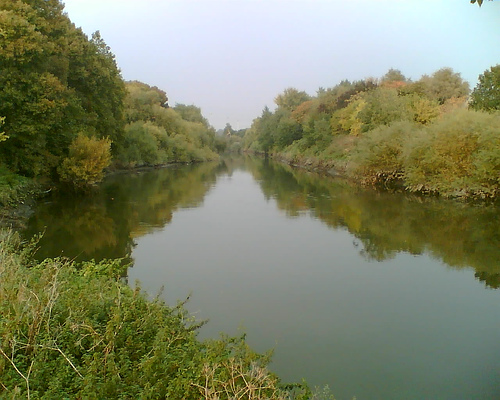
Hackney Marshes
Hackney Marshes is an area of open space in London's Lower Lea Valley, lying on the western bank of the River Lea. It takes its name from its position on the eastern boundary of Hackney, the principal part of the London Borough of Hackney, and from its origin as an area of true marsh.
The marshes were extensively drained from medieval times onwards, and rubble was dumped here from buildings damaged by air raids during World War II, raising the level of the ground.
The principal area of the marsh lies below Lea Bridge Road between the Old River Lea, and the Hackney Cut – an artificial channel of the Lee Navigation, dug about 1770, to avoid a loop in the natural watercourse. The southern extent is marked by the A12; although the industrial land around Hackney Wick Stadium was originally an extension of the marsh, it now forms a part of the Olympic Park for the 2012 Summer Olympics.
Hackney Marsh is one of the largest areas of common land in Greater London, with 136.01 hectares (336.1 acres) of protected commons.
The river itself was always an important waterway, being navigable to Hertfordshire; the Marsh was formed by the periodic flooding of the river, and so formed useful pasture, but could not be occupied permanently. Before the 10th century, the estuary of the river came as far as Hackney Wick, crossed at Old Ford. Marsh Road, the continuation of Homerton High Street, led to the marshes, and thence to Temple Mills. The Romans appear to have built a significant stone causeway across the marshes here; a periodical, the Ambulator of 1774, noted
there have been discovered within the last few years the remains of a great causeway of stone, which, by the Roman coins found there, would appear to have been one of the famous highways made by the Romans
The river forms a natural boundary, so in 527 AD it formed the boundary between the Saxon kingdoms of Essex and Middlesex. In the 9th century, it formed a part of the Danelaw boundary and reputedly, King Alfred stranded an invading Viking fleet here in 895 AD. This was achieved by draining the river where it met the River Thames, but the increased drainage affected river navigability, until it was restored in the 17th century.
By medieval times, both sides had become counties in England, and attempts were made to control the flow of water through the marshes. Mills were established including the Knights Templar mill at Temple Mills. Much of the marsh was 'owned' by the Templars and used for pasture. When the Templars were abolished, the land passed to the Knights Hospitaller, and thence to the Crown during the Reformation, when monastic lands were seized. At this time, much of the land was associated with the Hackney village of Lower Homerton and with the large manor house at Hackney Wick.
Hub AI
Hackney Marshes AI simulator
(@Hackney Marshes_simulator)
Hackney Marshes
Hackney Marshes is an area of open space in London's Lower Lea Valley, lying on the western bank of the River Lea. It takes its name from its position on the eastern boundary of Hackney, the principal part of the London Borough of Hackney, and from its origin as an area of true marsh.
The marshes were extensively drained from medieval times onwards, and rubble was dumped here from buildings damaged by air raids during World War II, raising the level of the ground.
The principal area of the marsh lies below Lea Bridge Road between the Old River Lea, and the Hackney Cut – an artificial channel of the Lee Navigation, dug about 1770, to avoid a loop in the natural watercourse. The southern extent is marked by the A12; although the industrial land around Hackney Wick Stadium was originally an extension of the marsh, it now forms a part of the Olympic Park for the 2012 Summer Olympics.
Hackney Marsh is one of the largest areas of common land in Greater London, with 136.01 hectares (336.1 acres) of protected commons.
The river itself was always an important waterway, being navigable to Hertfordshire; the Marsh was formed by the periodic flooding of the river, and so formed useful pasture, but could not be occupied permanently. Before the 10th century, the estuary of the river came as far as Hackney Wick, crossed at Old Ford. Marsh Road, the continuation of Homerton High Street, led to the marshes, and thence to Temple Mills. The Romans appear to have built a significant stone causeway across the marshes here; a periodical, the Ambulator of 1774, noted
there have been discovered within the last few years the remains of a great causeway of stone, which, by the Roman coins found there, would appear to have been one of the famous highways made by the Romans
The river forms a natural boundary, so in 527 AD it formed the boundary between the Saxon kingdoms of Essex and Middlesex. In the 9th century, it formed a part of the Danelaw boundary and reputedly, King Alfred stranded an invading Viking fleet here in 895 AD. This was achieved by draining the river where it met the River Thames, but the increased drainage affected river navigability, until it was restored in the 17th century.
By medieval times, both sides had become counties in England, and attempts were made to control the flow of water through the marshes. Mills were established including the Knights Templar mill at Temple Mills. Much of the marsh was 'owned' by the Templars and used for pasture. When the Templars were abolished, the land passed to the Knights Hospitaller, and thence to the Crown during the Reformation, when monastic lands were seized. At this time, much of the land was associated with the Hackney village of Lower Homerton and with the large manor house at Hackney Wick.